Loading document...
INFORMATION
07 OCT 2013 DEPARTMENT OF INFRASTRUCTURE
Mallards, Santon Proposed Botanic Gardens Transport Planning Statement
DEPARTMENT OF INFRASTRUCTURE PLANNING and BUILDING CONTROL
Act 1999 Officer Initials
Issue date: 02 Oct 13
Documentation? 13/00832
1709 - Private Dwelling, Santon – Estate Masterplan
| Decision | |
| Appeal |
Document title Mallards, Santon Proposed Botanic Gardens Transport Planning Statement
| Report Ref | 1709 | Created | 16/09/13 |
| Author | Alan Bailes | Checked | Alistair Burroughs |
| Signed | Alan Bailes | Signed | A Burroughs |
Document revision: A Issue date: 02 Oct 13
| Document tracking | Revision | Description | Issued by: | Date | Checked |
| A | Update | AB | 02-10-13 | ACB |
1709 - Private Dwelling, Santon – Estate Masterplan
^{}[]
1.0 Introduction 2.0 The Existing Highway Network 3.0 The Development Proposals 4.0 Relevant Policies in Respect of Transport 5.0 Traffic During Construction 5.1 Introduction 5.2 Construction Traffic Levels 5.3 Construction Traffic Proposals 5.4 Summary 6.0 Access and Parking Arrangements upon Completion 6.1 Introduction 6.2 Means of Access and Parking for Staff 6.3 Means of Access and Parking for Visitors 6.4 Means of Access for Service Vehicles 6.5 Internal Circulation Proposals 6.6 Summary 7.0 Summary and Conclusion
Appendix A Site Location in respect of the Local Highway Network Appendix B Planning Applications in relation to Development Appendix C Location of Construction Traffic Access
^{}[]
PA 13/00830/B: Creation of Production House and Walled Garden: Area E PA 13/00831/B: Creation of Water Cascade and Amphitheatre: Area D PA 13/00832/B: Creation of Meadow, Orchard, Lake, Wetlands, Boglands and Glen: Area B PA 13/00833/B: Creation of Gardener's Compound and Sensory Garden: Area C
This "Transport Supporting Statement" (Report) is in support of the above Planning Applications for the creation of a "Botanical Gardens" in an area surrounding "Mallards", at Santon in the south of the Island.
Appendix A shows the strategic location of the proposed Botanical Gardens in respect of the local highway network. Appendix B shows the relationship of the Planning Applications within the proposed development.
This Report has been prepared as part of the planning application discussion process in advance of the Transport Assessment and addresses the initial concerns expressed by the Department of Infrastructure's Highways Division, namely:
The Report therefore describes the existing highway network adjacent to the proposed development, the pertinent aspects of the development proposals, relevant transport policies as they relate to the proposals, resultant construction traffic plan and the proposed means of access; together with the parking arrangements and the internal traffic circulation proposals.
The proposed Botanical Gardens site is located between the A5 and A25 to the south west of Douglas. The site is bisected by the B26 Ballavale Road which connects the A5 at Santon and the A25 at Glen Grenaugh.
The A5 to the north of the site is a main route between Douglas and the south of the Island. It is a single carriageway road, typically between some 6.5m and 7.3m wide. It is constructed to a good standard and is generally well-aligned. The A5 has a speed limit of 50mph along its length in the vicinity of the proposed development site.
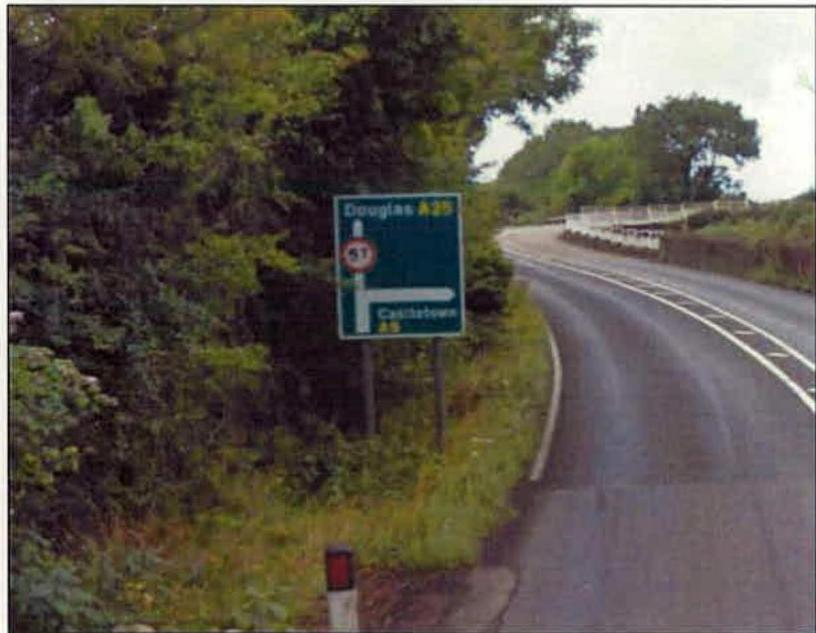
The A25 Old Castletown Road to the south of the site is also a single carriageway road, but is narrower than the A5 at typically 5.5m to 6.0m. It is also the subject of a 50mph speed limit along its length in the vicinity of the proposed development site. The A25, while signed for Douglas at its junction with the A5, is not as well aligned particularly in the vicinity of the A5 junction and immediately to the south of the site. Furthermore, the A25 is subject to a weight restriction between the A5 and the bridge over Santon Burn, which is single lane only.
The weight restriction extends between the A5 junction and the first side road junction off the A25 to Arragon Moar immediately to the east of the river bridge. The weight restriction limits access to vehicles of five tonnes or less over this section. The weight restriction is signed at the A5, as is illustrated in Figure 2.1.
Figure 2.1 - A5 / A25 Junction – Weight Restriction Signing
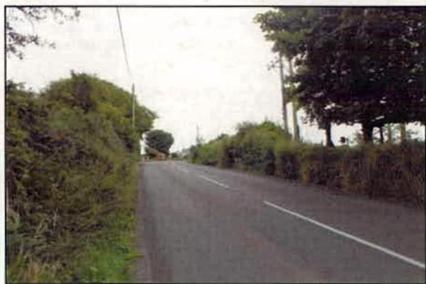
The proposed development is bisected by the B26 Ballavale Road. Ballavale Road is narrow at some 5.0m to 5.5m and is poorly aligned in parts, with poor visibility at its junction with the A25. Ballavale Road is derestricted in terms of its speed limit. Due to the nature of the road, speeds along the B26 as observed, very rarely exceeded 30mph. Visibility at the Ballavale Road junctions with the A25 is illustrated in Figure 2.2.
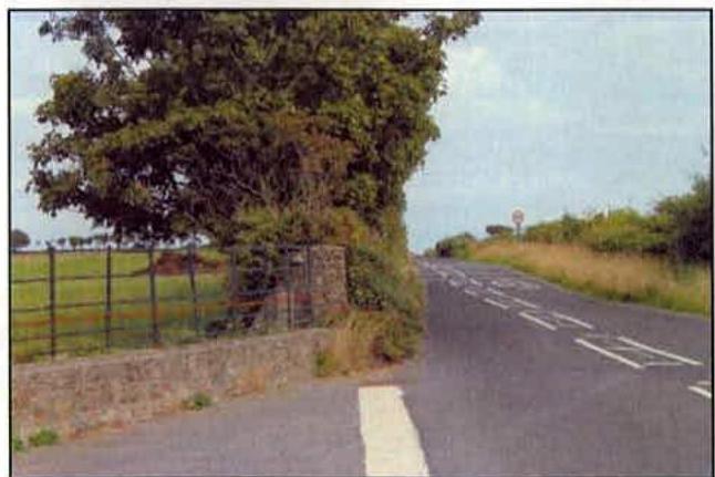
Figure 2.2 - Ballavale Road / A25 – Junction Visibility
To the north east of the proposed development site is the B24 Oatlands Road which provides a further connection between the A5 and A25 in the vicinity of the site. Again, this is a single carriageway road with a speed limit of 50mph. Oatlands Road is of straight alignment between the A5 and A25 and is wider than the B26 Ballavale Road at some 6.0m.
Oatlands Road currently provides access to an existing quarry and is therefore already in regular use by HGVs. Oatlands Road benefits from good visibility at its junctions with the A5 and A25 and is illustrated in Figure 2.3 and 2.4.
Figure 2.3 - Oatlands Road / A5 – Junction Visibility
Figure 2.4 - Oatlands Road / A25 – Junction Visibility
The site proposed for the Botanical Gardens is located in the south of the Isle of Man in the parish of Santon, off Ballavale Road and also just off the Old Castletown Road. The site has access to the A5 and A25 for existing properties on-site as well as extensive frontage to Ballavale Road and to the A25 to the east of the B26 Ballavale Road junction.
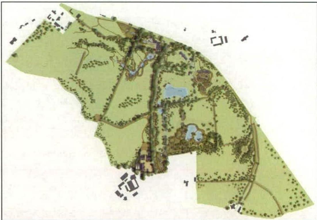
The site extends to some 300,000sqm (73 acres) and includes the existing properties of Ashdowne House and Mallards. There is planning consent for a further dwelling at Ashdowne House which is currently under construction.
The proposals will create an extensive area of Botanical Gardens containing various species and different ecological areas, many of which will be graded and landscaped. The proposals will include a network of informal paths connecting these areas within the site. There will be an amphitheatre, pools and lakes.
The four Planning Applications under consideration include only limited construction of buildings, mainly centred around a proposed Gardener's Compound, located on the southern edge of the Gardens.
The proposals will create an Estate and associated buildings that will contribute significantly to the Island's heritage by creating a Botanical Garden of global standing.
Figure 3.1 The Development Masterplan Proposals
It is intended that the Gardens will have restricted access which will be controlled and limited to invited groups whom will be advised to arrive by minibus and / or steam train to Santon Station, from where they may be collected. Scheduled events at the amphitheatre will correspond with the train times or especially organised trains.
The development proposals are explained in more detail in the Design Statement: Masterplan.
The Isle of Man Strategic Plan – Towards a Sustainable Island (2007) sets out the Department’s general policies in respect of the development and other use of land in the Island. The Strategic Plan states that the core purpose of Government is:
“To maintain and build on the high quality of life enjoyed by the Island’s community”.
In respect of Transport and Infrastructure, the Strategic Plan states that:
“In order to help meet the environmental objectives contained within this Plan, new development should where possible be located and planned so as to reduce the need for travel and encourage means of travel other than by private car, in particular walking, cycling and public transport use”.
The proposed Botanical Gardens are clearly in accordance with the above policy aims. The Gardens will add considerably to the high quality of life enjoyed by the Island and access to the Gardens will be by sustainable means of transport.
Traffic during construction will need a safe means of access and egress while the building and landscaping works are on-going. The purpose of this section of the Report is to address the issue of construction vehicle access and egress that might arise during the currency of the works and to give an indicator of the traffic levels anticipated.
It is anticipated that the proposed build-out of the Gardens will take place over a number of years and will be undertaken in a phased development approach.
The construction of the Gardens will require access by low loaders for plant and equipment, rigid HGVs and small builders trucks. It is expected that the Gardener's Compound will have limited building construction materials to be delivered, with a requirement for the larger vehicles in the region of ten over the build-out period.
Whereas it may be expected that rigid HGVs will import materials required for landscaping of the Gardens, "The Design Statement: Masterplan" indicates how the engineering works will be undertaken. It is anticipated that delivery vehicles will be accessing the site with soil, gravel, earth and stone as required.
Bulk movement of materials off-site is not expected, as it is planned to have a balanced "cut and fill" with, for example, spoil extracted to form the lake retained elsewhere on the site, perhaps in the formation of the glen. This will serve to significantly reduce the numbers of trips required to import or remove earth and spoil. Once on-site, all earth-moving equipment will remain in-situ throughout the build period. As a consequence, it is expected that during the build period, there will be very few construction traffic trips associated with the proposed development.
A number of physical constraints have been identified on the local road network in the vicinity of the site within Section 2. These include:
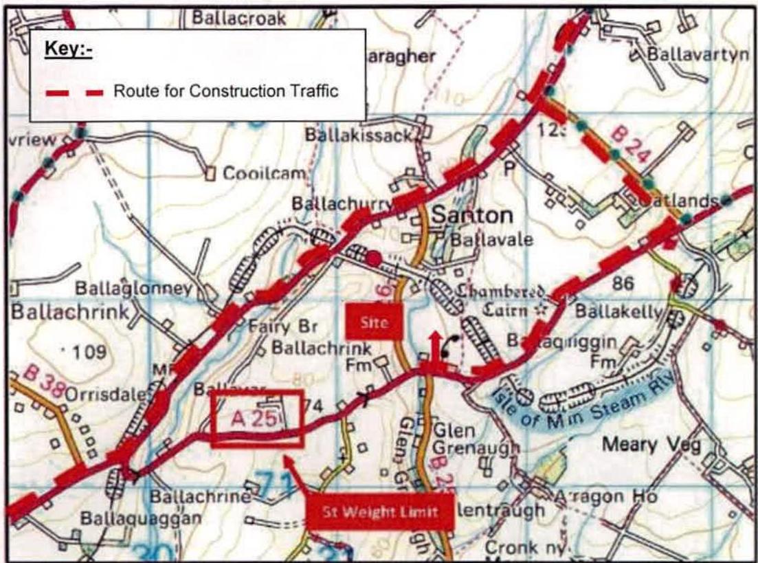
In view of the above constraints, it is considered that the optimum route by which to access the site for construction traffic will be via the A5, either from Douglas and the port to the north, or from the south of the Island, thence via the B24 Oatlands Road and a short section of the A25 that is not subject to the weight restriction. This route is illustrated in Figure 5.1.
Figure 5.1 - Proposed Route for Construction Traffic
It is expected that the proposed route can be secured by an appropriate planning condition to ensure that all construction traffic will use this route. The route can be further enforced on the ground through the provision of appropriate, temporary signing during the build-out period, to the satisfaction of the Developer, Contractors and the Highway Authority.
While the site does have existing points of access, they are currently in use for residential purposes only. Consequently, it is not considered that these accesses should form appropriate points of site access for prolonged construction traffic.
The site does, however, have extensive frontage to both B26 Ballavale Road and to the A25 Old Castletown Road to the east of its junction with Ballavale Road. As noted previously within this Report, Ballavale Road is somewhat narrow and poorly aligned by comparison to other roads around the site. In view of this, consideration has been given to providing a temporary site access, solely for the purposes of construction traffic, from the A25 east of Ballavale Road.
It is presently proposed as part of the Botanical Gardens to place underground the existing overhead cables that currently cross the site. The cables cross the A25 just to the east of the location of a telephone box on the A25, some 150m to the east of the Ballavale Road junction.
In view of the excavation works that will necessarily take place to bury the cables, it is proposed to utilise the opportunity created to form a temporary construction access. Visibility at the proposed access has been given consideration accordingly. Visibility is extensive to the west and to the east, whereby it is expected to be in the region of 2.4m x 60m, or more. The Developer controls land around this location and the available visibility could be improved, if required. The construction traffic site entrance is shown in Appendix C, whilst the visibility at this location is illustrated in Figure 5.2.
Figure 5.2 - Location of Proposed Site Access for Construction Traffic – Visibilities
The site is bisected by the B26 Ballavale Road and there will be occasions when construction vehicles will be needed to cross the road. A location has been identified for the purpose which will maximise visibility available to beyond 54 metres for crossing traffic. All construction traffic crossing Ballavale Road will be escorted by members of the Construction Team on foot to warn any approaching vehicles on Ballavale Road.
In addition to providing escorts for construction traffic crossing Ballavale Road, it is proposed to place appropriate warning signs on all approaches to the crossing provision. Subject to approval from the Highways Division, the section of Ballavale Road where the crossing point is located will be delineated by the use of a contrasting surface material.
In order to facilitate construction workers a small amount of temporary parking for about six vehicles will be provided in the vicinity of the construction traffic crossing point described above. Vegetation will be cut back in the vicinity of the crossing point to increase the visibility to beyond 54m for vehicles approaching from the temporary car parking arrangements onto the Ballavale Road.
This Report has considered the implications of construction traffic accessing and egressing the land proposed for Botanical Gardens at "Mallards", Santon, Isle of Man. The proposed Gardens would cover an area of some 300,000sqm.
The Report has reviewed the local road network in terms of width, alignment and visibility at junctions. This has revealed that there are a number of locations where the local road network is inappropriate for construction traffic.
Copyright in submitted documents remains with their authors. Request removal