‘Supporting Planning Statement’, Sarah Corlett Town Planning Consultancy.
For the Proposed
Equestrian Facilities
At Ballamona Estate, Quines Hill, Port Soderick.
PLANNING STATEMENT TO SUPPORT THE ERECTION OF EQUESTRIAN FACILITIES, BALLAMONA FARM, QUINE’S HILL, BRADDAN
Executive summary The site lies within an area designated as not for a particular purpose and where development is generally discouraged. Planning approval was granted for a building of a similar function, in the same place and of a similar size but different form and development commenced but the current owner wishes to amend the scheme to better suit their needs and their future plans for the estate. Following this approval the land was then used for equestrian purposes in addition to agriculture. We believe that it can be demonstrated the proposed works comply with the Strategic Plan policies which protect the countryside in compliance with the objectives of the Strategic Plan policies and the development will have an acceptable impact on the landscape and environment.
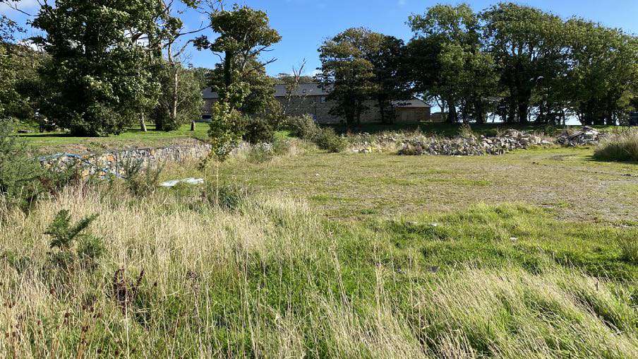
A photograph showing a grassy field with tall vegetation in the foreground and a line of trees with a stone building in the background.
1.0 INTRODUCTION
1.1 Ballamona Farm estate comprises a significant area of farmland which stretches from the Isle of Man Steam Railway line to the Old Castletown Road (A25). There are two accesses into the farm yard area, both from the A25.
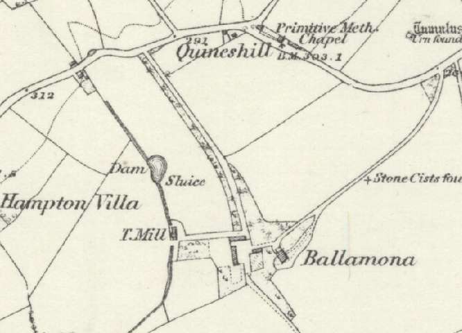
1.2 The farm accommodates a number of buildings most of which appear on the 1860s County Series maps - the farmhouse, manor house, outbuildings and mill:
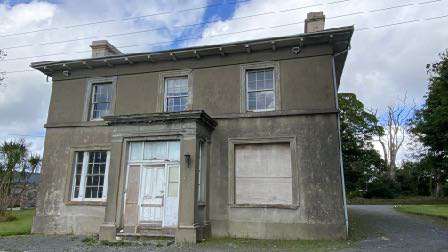
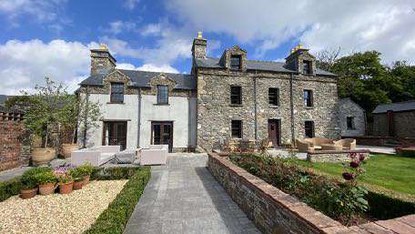
1.3 There is a manor house which sits at the eastern edge of the group and is a hipped roofed dwelling which is presently unoccupied. This has previously had approval for replacement (see Planning History).
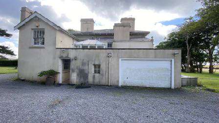
1.4 To the west of this, only 20m at the closest point and separated by two small outbuildings, is what is believed to be the original farmhouse which has been extended over time (see Planning History).
A historical black and white map showing the Quineshill and Ballamona area with field boundaries, roads, and building labels like Hampton Villa.A photograph showing a two-story, weathered building with a white door and boarded window, situated in a rural setting.A photograph of an existing single-story building featuring a large white garage door and a two-story section, set on a gravel driveway in a rural environment.
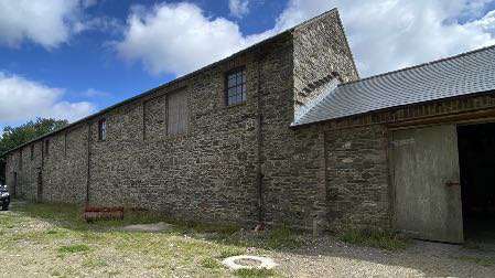
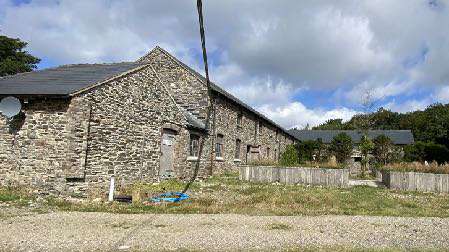
1.5 To the west there is a now L shaped stone outbuilding, formerly barns but with permission for use as offices (see Planning History). On the 1860s maps this building is split into two. Permission has
been recently sought for the conversion of these outbuildings to residential accommodation with extensions and alterations (22/01167/B - currently pending consideration).
1.6 In front of the farmhouse are formal gardens with raised beds and a pizza oven with stone and brick walling.
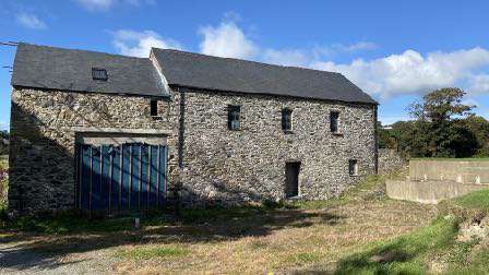
1.7 To the west is a mill which also has planning approval for conversion which has commenced.
1.8 To the south of the mill is an area that has been excavated in preparation for the approved equestrian development (see Planning History) and gabion baskets installed to form a retaining wall.
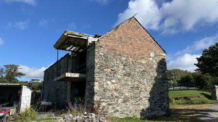
A large stone and rendered building with a paved driveway and extensive landscaping featuring low brick walls and potted plants.A photograph showing a long stone barn or agricultural building with a corrugated roof extension on the right side.A photograph showing a large, traditional stone barn or agricultural building situated on a rural site with gravel and grass in the foreground.A photograph of a large, traditional stone agricultural building with a slate roof and a modern blue gate, situated in a rural grassy field.A photograph showing a dilapidated stone barn or outbuilding with a damaged roof structure, situated in a rural setting with grass and trees in the background.
1.9 An access has been created to this excavated area in accordance with the approval granted in this part of the site, demonstrating that that approval was implemented.
1.9 Finally, to the east of the mill is a manège.
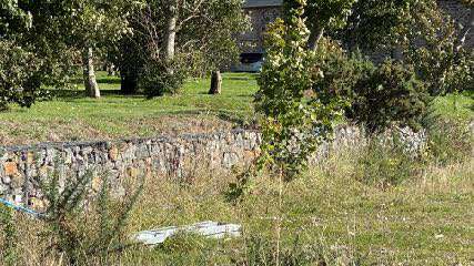
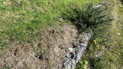
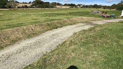
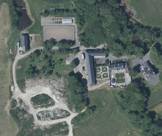
A photograph showing a grassy field with a low stone wall and trees, likely depicting the existing site conditions for the proposed equestrian facilities.A ground-level photograph showing a grassy field area with a low stone wall and some shrubbery.A photograph showing a grassy field with a gravel track running through it, depicting the existing site conditions.Aerial satellite view of Ballamona Estate showing the indoor riding arena, stabling blocks, and surrounding rural landscape.
2.0 Planning history
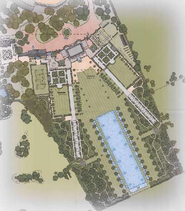
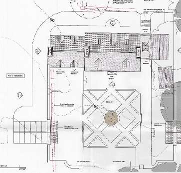
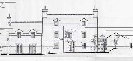
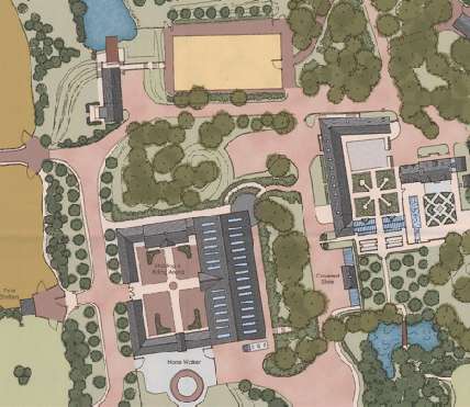
An illustrated site plan showing the layout of proposed equestrian facilities, including riding arenas, stabling, and landscaping.This image shows a detailed architectural floor plan or site layout for proposed equestrian facilities, including an indoor arena and stabling blocks.This image displays an architectural elevation drawing of a large manor-style house and an adjacent smaller outbuilding structure.
2.1 The site has been the subject of a number of applications which are set out as follows, separated into each section of the site:
2.2 Manor House
2.2.1 04/01191/B - roofing over internal yard area - permitted
2.2.2 12/01245/B - erection of replacement dwelling with garage block and landscaping - permitted
2.3 Farm House
2.3.1 10/00493/B - alterations, extensions and renovation of existing dwelling - permitted
2.3.2 18/00228/B - extension to farmhouse and barn, development of private equestrian facilities with horse walker, relocation of poly tunnel and associated landscaping - withdrawn
2.4 Barns
2.4.1 10/00339/B - conversion of barns into estate office with facilities - permitted and commenced: the upper floor was converted and has been used for office use: the lower floor is in the process of being converted. Recent application submitted for conversion to residential use with alterations and extensions (22/01167/B).
2.5 Mill
2.5.1 90/04196/A - approval in principle for conversion of derelict mill into a dwelling - permitted
2.5.2 10/00340/B - conversion of mill into a private dwelling - permitted.
2.5.3 10/01468/B - conversion of redundant mill into private residential accommodation - permitted
2.6 Additional development
2.6.1 11/00489/B and 11/00898/B - erection of a stable block to the north of the farm yard approved
2.6.2 12/01285/B - erection of equestrian facilities including stables, staff facilities and indoor riding arena - approved
2.6.2 17/00294/B - erection of poly tunnel approved
2.6.3 17/00738/B - erection of poly tunnel - approved
2.6.4 17/01001/B - extension of existing manège -approved
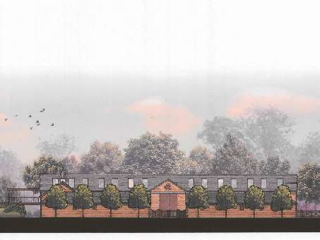
An illustrated site plan showing the layout of buildings, driveways, and extensive landscaping features on a property.An architectural elevation rendering depicting a long, single-story agricultural building with a pitched roof, surrounded by trees and landscaping.
3.0 Planning policy
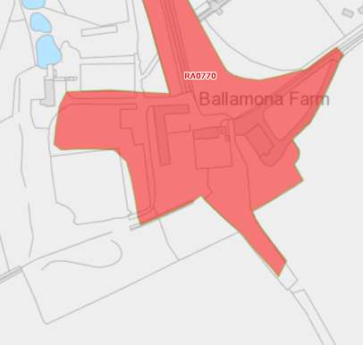
A site plan map highlighting the Ballamona Farm area in red, showing the proposed development boundary near road RA0770.
3.1 The site of the proposed development, including the existing manège, lies within an area not designated for a particular purpose and just outside the Active Travel Investment Plan area on the Area Plan for the East adopted by Tynwald in 2020. The entire farmyard, just excluding the mill building, the existing manège and proposed development and possibly the tree to be removed, is identified as an area containing Registered Trees. This is confirmed on the Government mapping which identifies Registered Tree Area 0770 in this location.
3.2 The site lies within an area designated on the Braddan Local Plan of 1991 as within an area of an area of High Landscape or Coastal Value and Scenic Significance. However, the Area Plan for the East clarifies that this system of landscape classification has now been superseded by the Landscape Character Assessment, which designates this site as part of a much larger area of Incised Inland Slopes (Douglas Head) and where the following landscape strategy is:
Conserve and enhance:
a) the character, quality and distinctiveness of the area, with its open and panoramic views over large rectilinear fields;
b) its steep winding small lanes enclosed by grassed Manx hedges;
c) its scattered hill farms fringed by trees.
Key Views Open and expansive views from most of the area out to sea, along the coast, over Douglas Bay and inland over the incised inland plateau up to the northern Uplands.
Telecommunications tower on hill top forms highly visible landmark in surrounding areas
3.3 This landscape area is distinct from the Rugged Coast which sits to the south around the Marine Drive where the key views are “open expansive and panoramic views out to sea from Marine Drive and from coastal footpaths including Road ny Foillan, views along the rocky coastline over various prominent headlands and view out to sea form Port Soderick framed by rocky cliffs.
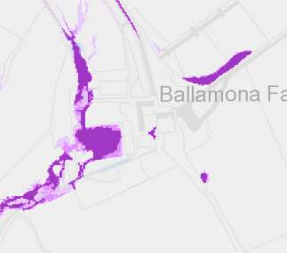
3.4 Parts of the site are identified on the Government flood risk mapping as at risk of surface water flooding.
3.5 The site is not within a Conservation Area nor are any of the buildings within the site Registered or identified in the Braddan Local Plan as being worthy of consideration for such status. The Area Plan for the East contains no such list.
3.6 The countryside is protected for its own sake under Environment Policy 1 (Environment Policy 2 identifies the protection of the landscape character as the most important consideration although this designation no longer applies to the site following the adoption of the Area Plan for the East) and there is a general presumption against development as set out in General Policy 3. There are exceptions to this, including buildings essential for the conduct of agriculture or forestry and whilst no reference is made to development associated with equestrian activities, there are specific policies which allow for this. Environment Policies 19, 20 and 21 are set out in the Appendix and are worded differently to those which provide for agricultural development in that the former are allowed unless there is an adverse impact whereas the latter need to demonstrate need before being considered acceptable.
A map view showing land parcels at Ballamona Estate highlighted in purple, indicating the site boundaries for the proposed equestrian facilities.
3.7 The equestrian policies allow buildings and activities where there is no loss of local amenity, no loss of high quality agricultural land (Classes 1 and 2) and where there is no adverse impact on highway safety.
3.8 There is a presumption against large scale equestrian development in areas of High Landscape or Coastal Value and Scenic Significance unless there are exceptional circumstances which justify this and buildings must be appropriate to their use and sited so as not to be detrimental to the character and appearance of the countryside.
3.9 Specifically elements are provided with particular protection in other policies in the plan: trees are protected under Environment Policy 3.
3.10 Ecology is protected under Environment Policies 4 and 7.
3.11 Development which would be at risk of flooding or would increase flood risk elsewhere is presumed against (Environment Policies 10 and 13).
3.12 Development is presumed against in areas of Classes 1, 2, 2/3 and 3/2 (Environment Policy 14). The site lies in an area of Class 3 and Class 3/4 on the Agricultural Soils Capability map.
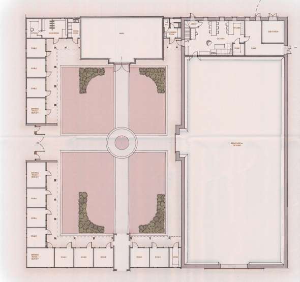
4.0 The proposal
This image displays a detailed architectural floor plan for a proposed equestrian facility, showing the layout of stables, an indoor arena, and associated rooms.
4.1 Proposed is the erection of a building for the stabling and exercise of horses, field shelters to the west of the main building, a new outdoor manège and a hay barn. A horse walker is proposed to the south east of the main building and an extension of the existing access and car park to the east of the main building which results in the removal of one tree to facilitate the horse box turning movements. Finally, the existing manège to the north is to be removed as part of the application, the hardcore used in the creation of the new facilities and the site restored to a level surface and for this area to be used in association with the mill. The exact use and appearance of this area will be the subject of further consideration in association with the development of the mill.
4.2 The main proposed building has a footprint of 35.5m by 62m, is 4.7m to the eaves and 8.7m overall compared with the approved scheme which was 5.7m to the eaves and 8.2m to the ridge. The building will be finished in aged timber cladding A 3m walkway will be created around the building to the north and east and 7m between it and the proposed manège. 40 solar panels will be installed, roof mounted, on the western plane along with a number of roof lights. The eastern plan will contain only roof lights, no solar panels.
4.3 The main building will have a ground floor which provides an internal arena which is 40m by 25m with 8 stables, horse wash and solarium, tacking up area, storage for a horse box and motorhome, rug store, tack room, food and bedding store, estate office, meeting room, boiler and plant roof, machinery store for tractors, mowers, trailer, quad bike, tool room, tea room and toilet and shower facilities including two accessible toilets with cloakroom facilities.
4.4 Above this in an area 10.5m by 35.5m is another floor of accommodation providing further storage facilities, a viewing area, gym and changing facilities although not all of this space is usable due to the pitch of the roof. Separate pedestrian access is available to this floor although it is also accessible from the ground floor of the building.
4.5 The scheme approved under 12/01285/B proposed a courtyard arrangement of buildings which at its longest was 49m by 46.5m with the main arena building having a footprint of 47m by 20m. This scheme had single storey stabling (eleven stables) forming the western extent of the courtyard with a taller barn along part of the northern elevation and a landscaped open area between the rear of the stables and barn and the main arena building.
4.6 The proposed hay barn has a footprint of 12m by 8m, an eaves level of 3.5m and a ridge height of 5.1m. It has one roller
shutter door with the other two thirds of the frontage being open. The building will have concrete blockwork between the stanchions up to a height of 1500mm with vertical timber cladding above that and a sheeted roof.
4.7 The field shelters to the west of the main building will have footprints of 4.8m by 13.2m with an eaves height of 2.25m and an overall ridge height of 2.77m. These structures will be finished in vertical timber cladding and a sheeted roof.
4.8 The solar panels require planning approval as they will be located outside the residential curtilage and do thus not comply with the the Town and Country Planning (Permitted Development) Order 2012 and as the building is equestrian which is not one of the Use Classes listed in the Town and Country Planning (Use Classes) Order 2019.
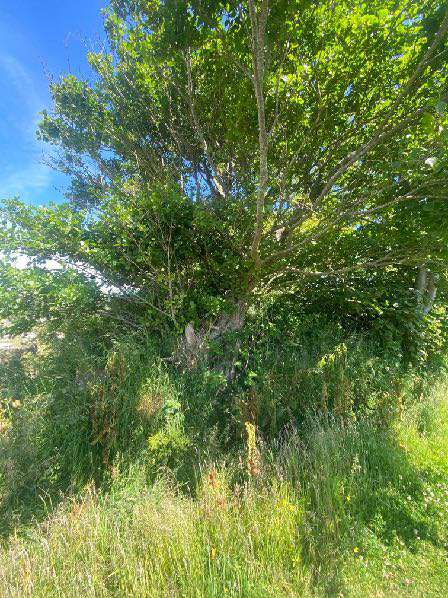
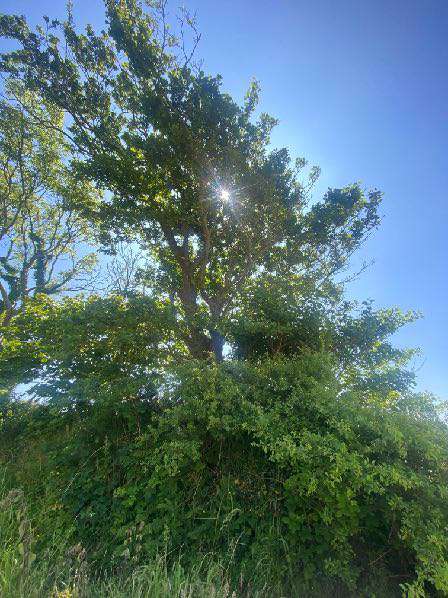
4.9 The tree to be removed is as a result of the need for large vehicles (motorhome and horse box) to gain access to the rear of the building from the existing car park and access. Whilst it would be possible to relocate this facility to the front of the building, this would necessitate further widening of the existing access track at the west of the building to allow for manoeuvring in and out and increase the spread of the development into the field. Access in this position would also be more affected by the prevailing wind. The tree, we believe is a self-seeded alder with griselinia hedging growing within:
A photograph showing a large, leafy tree with dense green foliage standing in a grassy field under a blue sky.A low-angle photograph looking up into the dense green canopy of a large tree with sunlight filtering through the leaves against a blue sky.
4.10 The tree is possibly just outwith the area of Registered Trees or if not, just within it at the edge of the group.
4.11 The applicant currently has two horses which are stabled in the existing stone buildings which are not as suitable for horses as a purpose built stable facility. One of the horses is to retire and will be put in foal and a replacement horse will be brought in. They also have three other retired horses living off site which they wish to bring to the site. There would therefore be a total of 6 or 7 horses on site with capacity for further horses to be kept on site if the need arises, including horses of family and friends. The estate is more than large enough to accommodate this amount of horses and more.
4.12 There is no intention for any of the proposed facilities to be rented out or used commercially.
5.0 Assessment of proposals
5.1 The site is located in the countryside and whilst is no longer within an area of High Landscape or Coastal Value and Scenic Significance as the Area Plan for the East has superseded this with the Landscape Character Assessment, it is considered that the protection of the countryside is still of paramount importance and what is proposed does not adversely affect that, either at all or in comparison with what has approval and is still capable of implementation.
5.2 The site is not easily visible, as was noted in the case of 12/01285/B and the site of the proposed equestrian buildings is surrounded by existing woodland and the mill with the backdrop of the farm house. The proposed building will be visible if one stops on the A25 between Hampton Court Lodge and Hampton Manor and looks over the hedge or through the existing gated entrance to the field, across the fields but where the vista is expansive and the proposed building a small part of it. This view has the mill building closer to the viper and the houses in the background so the view is not open and uninterrupted. Other potential views from the Port Soderick Road or Marine Drive are impeded by the existing topography and woodland. The dark coloured timber finishes and compact nature of the building will help it sit comfortably into this landscape.
5.3 Looking in detail at the equestrian policies in the Strategic Plan, EPs 19 and 21 are positively worded such that if the development would not fall foul of the elements contained in them, it should be considered to be acceptable. The issues are loss in local amenity, loss of high quality agricultural land and where the local highway network can satisfactorily accommodate any increase in traffic and where the design, site and finish do not adversely affect the character or appearance of the countryside and are suitable and appropriate for their purpose.
5.4 The buildings are to be sited on private land which is otherwise used or would be used had the site not been prepared for the development approved under 12/01285/B for grazing or as open space and for the grazing of animals. There is no loss of local amenity as a result of the development which will be on the same footprint as the approved equestrian development.
5.5 The land in question is Class 3 or 3/4, there is as such no loss of high quality agricultural land as a result of the proposal which is in the same area as the previously approved development which remains capable of implementation.
5.6 The proposal will not result in any adverse impact on the local highway network as all the facilities will accommodate horses which are or will be already on the site and there is to be no commercial or other use of any of the facilities. The applicants would be happy to accept a reiteration of the condition which was attached to the previous approval, amending the reference to the appropriate plan:
The equestrian facilities hereby approved may not be operated as a commercial facility separate from the operation and occupation of Ballamona Farm estate as defined in blue on drawing reference 1003 X 1001.
5.7 As stated above, the impact of the development on the landscape is considered to be negligible and certainly no greater than that of the previously approved scheme.
5.8 The materials and size of the proposed development are appropriate to their use and their use proportionate to the amount of land within the estate. The incorporation of solar panels within the
main building will contribute to the efforts to address Climate Change and will be used solely to provide renewable energy for the site which is sizeable and comprises a range of uses.
5.9 The development is what could be considered large scale and it is within an area which previously was designated as an area of High Landscape or Coastal Value and Scenic Significance. Whilst there is a presumption against such developments, it is highly relevant that a similar sized scheme was previously approved in the same area and this is still capable of implementation. In addition, the land is not particularly good agricultural land and the proposal will conserve and enhance the character, quality and distinctiveness of the area and not have a significant impact on the character and appearance of the landscape thus complying with the Landscape Character Assessment and Environment Policies 1 and 2 of the Strategic Plan. Other developments of indoor arenas have been approved in areas of High Landscape or Coastal Value and Scenic Significance including:
15/00166/B at Ballaclucas Farm in Marown 10/00059/B at The Nab Farm Marown 10/01672/B at Ballavartyn, Santon.
5.10 There are also other policies within the Strategic Plan which need to be satisfied: there should be no adverse impact on trees of amenity value, ecology and no increased flood risk. The proposal will result in the removal of one tree which is not believed to be within the Registered Tree Area and its removal has no adverse impact on these important trees.
5.11 The proposed development is on a cleared area and thus there will be no impact on ecology.
5.12 Whilst some areas on the site are shown on the national flood risk maps as at risk of surface water flooding, the proposal will take account of this and include appropriate drainage including the disposal of foul and surface water from the building.
Sarah Corlett 31st October, 2022
Appendix One Strategic Plan policies
General Policy 3: Development will not be permitted outside of those areas which are zoned for development on the appropriate Area Plan with the exception of:
(a) essential housing for agricultural workers who have to live close to their place of work; (Housing Policies 7, 8, 9 and 10);
(b) conversion of redundant rural buildings which are of architectural, historic, or social value and interest; (Housing Policy 11);
(c) previously developed land(1) which contains a significant amount of building; where the continued use is redundant; where redevelopment would reduce the impact of the current situation on the landscape or the wider environment; and where the development proposed would result in improvements to the landscape or wider environment;
(d) the replacement of existing rural dwellings; (Housing Policies 12, 13 and 14);
(e) location-dependent development in connection with the working of minerals or the provision of necessary services;
(f) building and engineering operations which are essential for the conduct of agriculture or forestry;
(g) development recognised to be of overriding national need in land use planning terms and for which there is no reasonable and acceptable alternative; and
(h) buildings or works required for interpretation of the countryside, its wildlife or heritage.
Environment Policy 1: The countryside and its ecology will be protected for its own sake. For the purposes of this policy, the countryside comprises all land which is outside the settlements defined in Appendix 3 at A.3.6 or which is not designated for future development on an Area Plan. Development which would adversely affect the countryside will not be permitted unless there is an over-riding national need in land use planning terms which outweighs the requirement to protect these areas and for which there is no reasonable and acceptable alternative.
Environment Policy 14: Development which would result in the permanent loss of important and versatile agricultural land (Classes 1-2) will not be permitted except where there is an overriding need for the development, and land of a lower quality is not available and other policies in this plan are complied with. This policy will be applied to
(a) land annotated as Classes 1/2 on the Agricultural Land Use Capability Map; and
(b) Class 2 soils falling within areas annotated as Class 2/3 and Class 3/2 on the Agricultural Land Use Capability Map.
Environment Policy 19: Development of equestrian activities and buildings will only be accepted in the countryside where there will be as a result of such development no loss in local amenity, no loss of high quality agricultural land (Classes 1 and 2) and where the local highway network can satisfactorily accommodate any increase in traffic (see Environment Policy 14 for interpretation of Class 1 and 2).
Environment Policy 20: There will be a presumption against large scale equestrian developments, which includes new buildings and external arenas, in areas with High Landscape or Coastal Value and Scenic Significance unless there are exceptional circumstances to override such a policy.
Environment Policy 21: Buildings for the stabling, shelter or care of horses or other animals will not be permitted in the countryside if they would be detrimental to the character and appearance of
the countryside in terms of siting, design, size or finish. Any new buildings must be designed in form and materials to reflect their specific purpose; in particular, cavity-wall construction should not be used.
Appendix Two Landscape Character Assessment D13 - SANTON Key Characteristics
• A predominantly rural landscape, dissected by A5 and A25 roads.
• Densely wooded valley bottoms amongst undulating rolling land with large rectilinear arable and pastoral fields on the gently sloping hill sides and rounded tops.
• Steep sided densely wooded Victorian pleasure Glens of Glen Grenaugh and Port Soderick Glen lead down to the coast.
• Victorian electric railway line and stations runs through the area at the bottom of Crogga Glen.
• Fragmented woodland along field boundaries and along tracks that access the scattered farm houses centred around Quine’s Hill (along the A25) and small settlements of Santon and Ballaveare.
• Sea-facing hill slopes with large open fields running along the cliff tops with gorse, heather and bracken along the cliff top periphery.
• Incinerator chimney forms notable landmark in the immediate area.
• Presence of Manx Milestones.
• Abrupt linear southern built edge to Douglas, comprising residential and industrial development with minor localised extension of industrial character into character area south of Cooil Road.
• Pulrose Golf Course on edge of Douglas
Overall Character Description Numerous gentle to steeply sided river valleys cut down into the landform to form an undulating and rolling character with pronounced incised valleys. Glen Grenaugh and Port Soderick Glen are steepsided densely wooded valleys, the latter appropriated during the Victorian period as pleasure Glens with walkways and features such as bandstands and bridges. Linear fragmented woodland runs along the valley bottoms of these National Glens and along Crogga River. Hedgerow trees and woodland blocks surround the numerous farms in the area, which are predominantly located in the north of the area around Quine’s Hill.
Medium sized rectilinear arable and pastoral fields delineated predominantly by Manx hedges and some post and wire fences form a strong geometric field pattern on the gently sloping hill sides and rounded tops in the south of the area. Smaller rectilinear fields enclosed by Manx hedgerows, containing large hedgerow trees, cover the more settled north-eastern area where farmsteads such as Hampton Court and Cronkbane are concentrated. This field pattern stops abruptly in the north of the area where it meets the A24 and the linear built-up edge of Douglas. The far north-eastern part of the area comprises the Pulrose Golf Course, which extends in towards the centre of Douglas. Patches of gorse and heather grow in areas on the more exposed hill tops and along the eastern edges of the fields of the coastal facing slopes, along which the cliff top coastal path runs and forms the area’s seaward boundary.
The busy A25 runs along the lower valley sides with small, often steep and winding tracks branching off perpendicular from the main road to provide farm access, while smaller predominantly straight B roads, enclosed by tall hedgerow vegetation, which follow the grain of the rectilinear field pattern and link the small and wooded settlements within the area such as Santon and Seafield. The Victorian Electric Railway runs through the area along Crogga Glen with stations at Santon and Port Soderick before skirting around the bottom of Douglas Head which forms the north eastern boundary. Moderate sense of tranquillity away from Douglas and the major roads.
Key Views
• Open and expansive views from the higher areas along the rugged coast in the east and inland towards the upland areas over Braaid.
• Incinerator chimney forms a notable landmark in the immediate area.
• Glimpsed views framed by vegetation in the valley bottoms and along the main roads where they follow the wooded valley bottoms.
• Views in the northern part of the area up to the Transmitting Masts on top of Douglas Head hill top.
• Views from Isle of Man Steam Railway Historic Features
• Victorian Isle of Man Steam Railway and stations, including Port Soderick (Registered Building) and the Old Toll Booth (Registered Building). Ecological Features
• Farmland grassland habitats.
• Mature network of hedgerows containing deciduous trees in field boundaries.
• Aquatic and waterside habitats along river courses.
• Dense riparian woodland in Valley bottom with deciduous woodland along valley sides.
• Exposed heathland on steeper sea facing slopes. Key Issues and landscape sensitivities
• Wooded horizons and skyline seen from valley bottoms.
• Ecological value of the aquatic and waterside habitats.
• Various sized pastoral and arable fields with Manx hedges.
• Wooded valley bottom with fragmented woodland along substantial field boundaries. • Scattered farmsteads fringed by trees.
• Wooded Victorian Pleasure Glen at Port Soderick.
• Victorian Isle of Man Steam Railway and stations.
• Presence of Manx Milestones.
Landscape Strategy The overall strategy should be to conserve and enhance the character, quality and distinctiveness of the area, with its wooded valley bottoms and wooded horizons, its scattered settlement pattern, its Victorian pleasure glen and the railway.
Copyright in submitted documents remains with their authors. Request removal
Source & Provenance
Official reference
22/01386/B
Source authority
Isle of Man Government Planning & Building Control