PLANNING STATEMENT FOR THE REDEVELOPMENT OF BALLASHAMROCK FARMHOUSE, PORT SODERICK, BRADDAN
1.0 Introduction
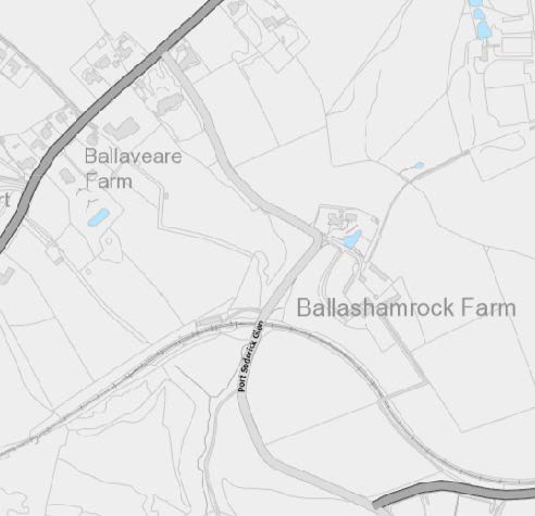
1.1 Ballashamrock Farm sits to the south east of the Port Soderick Glen Road (B23) which links the A25 Old Castletown Road with Marine Drive (A37) and Port Soderick beach and car park.
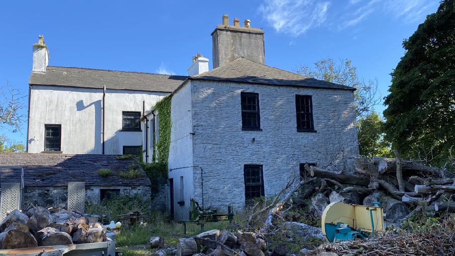
A site location map showing the area around Ballashamrock Farm and Ballaveare Farm with road networks and field boundaries.A photograph of a large, white-washed stone farmhouse with a pile of rubble and debris in the foreground.
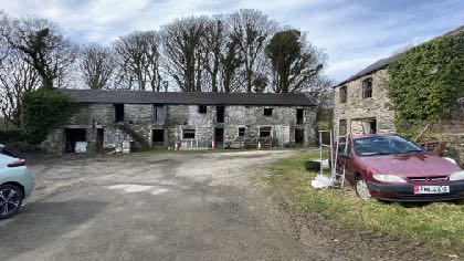
1.2 Ballashamrock Farm holding is currently farmed in association with Southampton Farm through family connections and both holdings have a range of farm buildings. Ballashamrock Farm accommodates a traditional farmyard which has a number of old stone barns, a larger, more modern shed to the north and three dwellings: Ballashamrock House which sits at the southern edge of the farm group; the old Ballashamrock farmhouse - an additional dwelling which is attached to the rear of Ballashamrock House and the newer farmhouse which sits at the eastern edge of the group and which replaced a former outbuilding (see Planning History). Ballashamrock House is in separate ownership from the rest of the farm and has been for some considerable time (see Planning History).
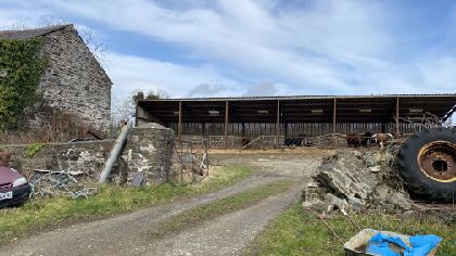
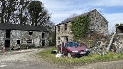
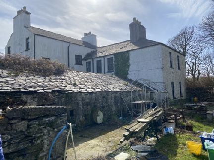
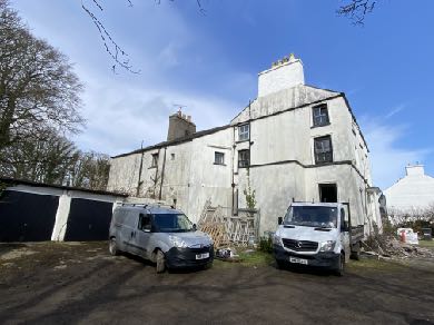
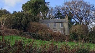
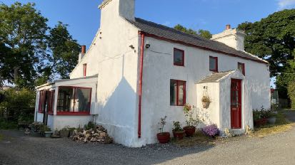
This is a photograph of a large, white-washed farmhouse-style building with a garage and two vans parked in the foreground. The image depicts the existing structure, Ballashamrock farmhouse, which is the subject of the application to replace it with a new dwelling.A photograph of a rural site featuring an old stone building on the left and a large open-sided agricultural outbuilding in the background, with a dirt track in the foreground.A photograph showing existing stone buildings on a rural site, including a single-story structure and a taller two-story building with a red car parked in front.A photograph of a long stone farmhouse or agricultural building situated in a rural area with vehicles parked on a gravel driveway.A photograph of a rural property featuring a white two-story farmhouse and adjacent stone outbuildings.A photograph showing a large white stone farmhouse with slate roofs and chimneys, alongside a lower stone outbuilding in the foreground.
1.3 There are other buildings outside of this group but are not considered relevant to the current proposals.
1.4 Access to the buildings is directly from the A23 up and around a farm lane into the yard which serves all of the buildings cited above. There is a separate route to Ballashamrock House from the access to the south west of the farm buildings and around to the side of Ballashamrock House. There is also a track which leads from alongside Ballashamrock House to Marine Drive, passing over the railway line, involving sharp 90 degree corners and skirting the fields.
1.5 The internal layout of the two properties reveals that Ballashamrock House had three floors of accommodation including a lower floor/cellar whereas the farmhouse has only two floors. The mutual party wall differs in location per floor with the ground floor of the House extending underneath the upper floor bedrooms of the farmhouse with a resulting flying freehold arrangement for the owners of both properties and on the first floor, a wall running vertically through a window.
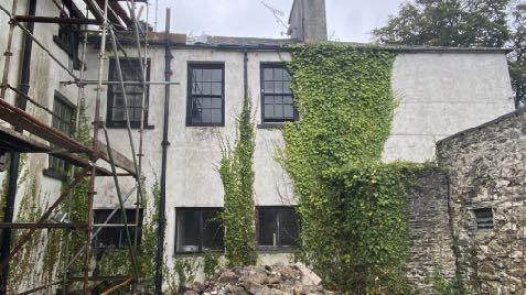
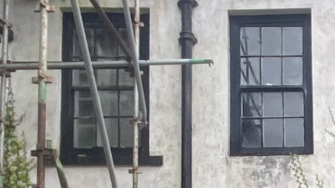
1.6 The owner of Ballashamrock House is currently in the process of renovating the house.
A photograph of a two-story white building with black windows, partially covered in ivy, with scaffolding on the left and a pile of rubble at the base.A close-up photograph of a building's exterior wall featuring two black-framed sash windows and a vertical drainpipe, with metal scaffolding visible on the left side.
2.0 Planning policy
2.1 The site lies within an area not designated for development on the Area Plan for the East which was adopted by Tynwald in 2020 so, a relatively recent development plan. The Area Plan has a number of plans associated with it which highlight various constraints including areas of Registered Trees (more clearly shown below right in red) and a site of archaeological interest/Ancient Monument between the farmyard and Marine Drive:
2.2 This Ancient Monument is not listed as amongst the most notable in the plan area (paragraph 6.12.1) although the Plan has a policy which specifically protects Ancient Monuments as follows:
Urban Environment Proposal 6 Applications on sites or close to sites that contain an Ancient Monument must be designed taking into account the character of the Monument and its environs to ensure it is satisfactorily protected.
2.3 This is similar to Environment Policy 40 of the Strategic Plan:
Environment Policy 40: Development will not be permitted which would damage, disturb or detract from an important archaeological site or an Ancient Monument or the setting thereof.
2.4 Trees are generally protected under Environment Policy 3. There is likely to be a presumption against the loss of any Registered Tree unless this is justified.
2.5 Ecology is protected under Environment Policy 4.
2.6 There is a general presumption against development in undesignated areas, as set out in General Policy 3 of the Strategic Plan (see Appendix One). Environment Policies 1 and 2 presume against development which would be harmful to the character and appearance of the countryside, EP 2 placing even more weight on the protection of the character and quality of the countryside. Environment Policy 2 refers to the areas of high landscape value and scenic significance but these
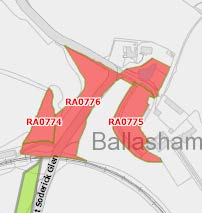
A site location map showing property boundaries, roads, and a specific site marked with a red circle containing the letter 'M'.A site plan showing red-shaded areas labeled RA0774, RA0775, and RA0776 near Soderick Glen and Ballasham.
have been replaced in the Area Plan for the East with the Landscape Character Assessment designations which characterise the countryside by the type of landscape rather than by its perceived quality.
2.7 This site lies within an area on the Landscape Character Assessment as part of the an area of Incised Slopes - D13 - Santon where the railway, field pattern, rural nature, wooded areas and Manx milestones are identified to be protected in the landscape strategy (see Appendix Two).
2.8 The Area Plan has a specific proposal for this area of landscape character:
Landscape Proposal 7 (Santon) In cases where new development is proposed, applications must demonstrate that it can be suitably integrated into the surrounding landscape setting through reasonable mitigation measures and considering siting, colours, materials, finishes and the general scale.
2.9 There is an area of potential risk of surface water flooding running north east to south west between the newer bungalows alongside the A23 and the farmyard on the national flood risk maps. The farmyard and Ballashamrock House and farmhouse are not shown as being at any risk of flooding.
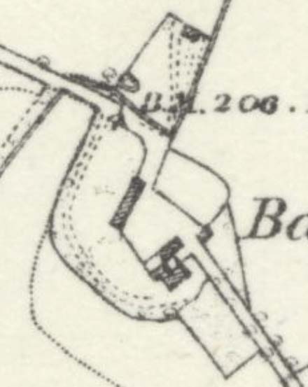
2.10 The buildings on the site are not Registered and the site is not within a Conservation Area. The farm group is on the 1860s County series maps where some of the current buildings appear. On this map, Ballashamrock House is not as large as it appears now as it has no side annex and possibly there was no Ballashamrock farmhouse at this stage and the building at the rear of Ballashamrock House was simply a rear annex - the barn currently running at right angles to the north east of Ballashamrock House is not there and the two storey stone barn to the east of the long two storey barn does not appear.
2.11 At some point between then and the 1930s the farmhouse was created at the rear of
A site plan showing the Ballashamrock property with purple boundary lines and surrounding road infrastructure.A close-up view of a site location plan or map showing building footprints, roads, and a benchmark elevation.
Ballashamrock House and Ballashamrock House was extended to the north east. No planning approvals appear to have been sought or granted for these although it is shown as a separate dwelling on a number of applications submitted after 1953 (see Planning History below).
2.12 Whilst there is a presumption against development in this area according to General Policy 3, there is provision for extensions of existing rural properties (Housing Policies 15 and 16) and also for the replacement of some rural dwellings (Housing Policies 12 and 14).
2.13 Ballashamrock House appears in John Kitto’s book “Historic Homes of the Isle of Man” (1990)
where it is referred to along with Crogga House where it states the following:
“The adjacent estates of Crogga and Ballashamrock House were both owned for something like a hundred years by the well known Quayle family of Castletown. In the eighteenth century when the Manx contraband trade was at its peak and smuggling was no offence under Manx law, both houses were used openly as convenient places to store ‘trade’ goods, for Port Soderick was a favourite landing place. In 1736, the British Customs Protection Act resulted in the increase of revenue cutters patrolling the Manx coast and made landing more difficult and in 1765 the British Government compelled the Duke of Atholl to surrender his Lordship of Mann to the Crown for £70,000 - a compulsory deal which both he and the Manx people resented - and the contraband trade was made illegal in this Island as well as in England. It still continued, as most of the leading Manx families were deeply involved in it and getting considerable profit from it - including the Quayles. These two estates were then still more important, for landings were made by night and it was only a very short distance to convey the goods to them in darkness. They were hidden there until they could be moved on, again by night. The Quayles never occupied either of these houses but they had stewards living there - who were also their agents in ‘The Trade’. In 1822 the steward living at Crogga was one William Hunter, a Scot and it was probably he who added or got his employer to add the Scottish Baronial type of frontage to Crogga House, which was formerly a plain Manx farmhouse very much like Ballashamrock House. Crogga and Ballashamrock are both very appropriately sited above Port Soderick Glen which leads directly to the shore”.
2.4 There is no reference to the farmhouse.
2.5 The Residential Design Guide makes reference to the need for sustainable construction and climate change resilience, recycling demolition materials and sustainable material sourcing. This supports the Climate Change Act 2021.
3.0 Planning history
3.1 The earliest planning application on record for this site is IDO 2022 in 1939 which was for an extension to a cow shed. This shows the farmhouse in existence as it appears today. This application was submitted in the name of The Estate of Miss Quayle deceased.
3.2 The next application in 1949 was for an overhead electricity line (IDO 6355) followed by alterations to the farmhouse in 1953 (IDO 9361). This shows the farmhouse laid out as shown here which shows the complicated internal relationship between the two properties with the wall running through the window on the first floor as it does now:
3.3 Subsequent to this there was permission granted for a feed shed store in 1955 (IDO 11152).
3.4 Permission was sought for the erection of a flat roofed garage in 1970 under IDO 28969 which currently sits to the south west of the farmhouse.
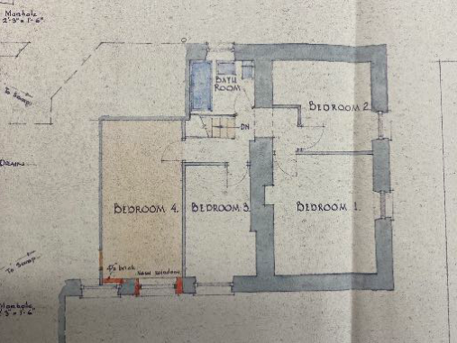
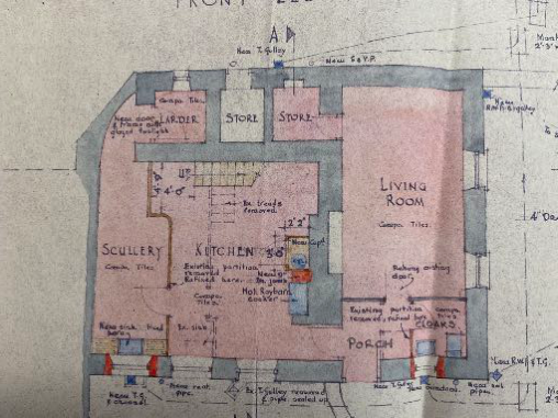
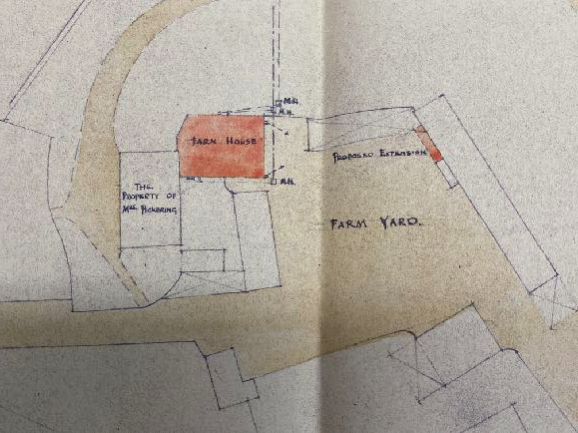
The image displays a hand-drawn architectural floor plan showing the layout of a proposed dwelling with four bedrooms and a bathroom.Architectural floor plan detailing the layout of a house with rooms like a living room, kitchen, and scullery.A hand-drawn site plan sketch showing the existing farm house, a proposed extension, and the surrounding farm yard and neighboring property boundaries.
3.5 A lean-to building was approved in 1973 under IDO 36648, and implement shed under IDO 10057 in 1954, a cow shed and dairy in 1954 (IDO 10187) and a grain silo and wall under IDO 44614 in 1977.
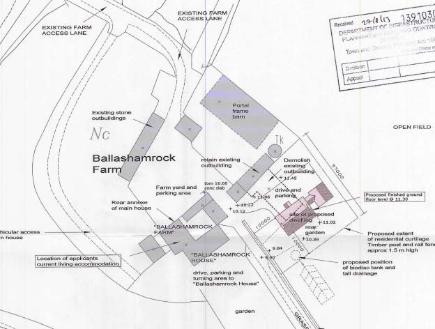
3.6 In more recent times no planning applications have been submitted other than for the erection of a new dwelling in place of an outbuilding which was demolished (13/91030/B). This is now in situ:
A site plan for Ballashamrock Farm showing existing farm buildings and the proposed location for a new dwelling with associated access and parking.
4.0 The proposal
4.1 Proposed is the demolition of Ballashamrock Farmhouse and the principle of its replacement in the form of a separate dwelling to the north west of its present location.
4.2 The farmhouse will be replaced by a new dwelling positioned between the existing farmhouse and the stone outbuilding to the north west. The details of this are not proposed at this stage other than the general siting, but if permission is granted the replacement dwelling would comply with the requirements of Housing Policy 14 in respect of size and design.
4.3 The demolition of Ballashamrock Farmhouse and the small parts of the rear of Ballashamrock House which encroach beyond the original four walls of the house will leave Ballashamrock House a simple rectangular footprint, potentially how it would have been when first built. The owner of Ballashamrock House is in the process of renovating it and is applying contemporaneously for extensions and this is proposed regardless of whether the farmhouse is demolished and/or replaced.
4.4 A bat survey is attached which confirms that “demolition of the building will have no impact on breeding bats. There is a remote possibility that demolition might remove hibernating space from individual bats but this would be impossible to assess, given the condition of the building. It is therefore recommended that demolition takes place outside the hibernation season (late Oct to early March depending on temperature).”
5.0 Assessment
5.1 The current arrangement of the two, separate dwellings is such that there is an unusual and uncomfortable layout which has resulted in an irregular and not overly attractive appearance of the farmhouse particularly but the overall appearance of the house as well. The current arrangement does not reflect the original appearance or arrangement of Ballashamrock House and the owner of that property wishes to reinstate the detached character of the house and at the same time, improve the amenities of the property. The demolition of the farmhouse and its relocation further away will enhance this. What will result from the proposal is the enhancement of Ballashamrock House which will be renovated and modernised, as well as the replacement of the farmhouse in a more modern and thermally efficient format and where the living conditions for the occupants of both properties privacy, outlook and space - are much improved.
5.2 The Strategic Plan provides opportunities for the replacement of existing houses. The appropriate policies to be applied here are whether the proposal complies with Housing Policies 12 and 14. Ballashamrock Farmhouse
5.3 Whilst neither house is in particularly good condition both have been lived in in the past ten years and both could be made habitable. Rates have also been paid on both properties and neither has had any other use since its last occupation as a dwelling. The Department is rightly, generally trying to retain houses which retain their original attributes and where the house is a good example of vernacular architecture. In the case of Ballashamrock Farmhouse, it does not appear that there is much in the way of notable architectural features, proportion or form and its history is unclear other than the fact that the two houses are definitely separate and the buildings in their present form have never been occupied as a single dwelling. Ballashamrock House is considered to be of some historic interest, and disassociating the farmhouse from it, would re-establish its original form. The building has a hipped roof, an asymmetric arrangement of windows in the north eastern elevation, a different arrangement of windows in terms of position and spacing, on the north western elevation and a different finish on the wall (lime washed stonework compared with smooth render on the other elevations) and a large, cement render unpainted chimney stack. The south western elevation is relatively featureless and not helped by the modern flat roofed garage alongside associated with the house.
5.4 The farmhouse is not in good repair although could be made so without the need for planning approval.
A photograph showing a large, white-washed, multi-story farmhouse with a chimney, situated in a rural setting with vehicles parked in the foreground.A photograph of a large white farmhouse with slate roofs and chimneys, featuring a lower stone outbuilding in the foreground.
5.5 The Planning Committee has accepted the replacement of traditional dwellings in the countryside: for example, 19/00952/B at Ballakaighen, Staarvey Road in German where the existing house was in such poor condition that it was financially and structurally not considered viable to retain the house and address the structural, damp issues. In this case the replacement house was almost identical to the existing it was to replace.
5.6 More recently, planning approval was granted for the replacement of a dwelling at Narradale (22/00385/B) where the Planning Committee was advised that the existing house was not habitable as it stood but could be without the need for planning approval and that it was not particularly public visible and that a replacement could achieve greater levels of thermal efficiency and contribute more to tackling Climate Change. The replacement house was over 500% larger than what exists.
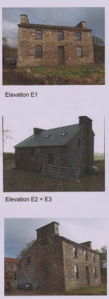
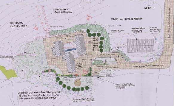
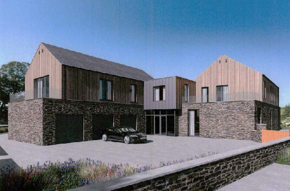
The image displays a series of elevation photographs of existing stone buildings on a rural site, including a two-story house and a single-story outbuilding.A technical site plan showing the proposed layout of a new dwelling, including landscaping features like wildflower meadows, access points, and parking areas.A photorealistic architectural rendering of a proposed modern detached dwelling featuring stone and timber cladding, a driveway with a car, and foreground landscaping.
5.7 Similarly, permission has just been given for the replacement of Ballasaig Cottage in Maughold: the existing was traditional although with an asymmetric arrangement of windows, and permission was granted for a much more modern and larger property (22/000225/B):
5.8 Also very recently planning approval was granted for the demolition and replacement of Ballahig Cottage:
5.9 It is notable that the demolition of either Ballashamrock House or Ballashamrock Farmhouse or both could be undertaken without planning approval*
5.10 It is clear from the above that the thermal and energy efficiency of properties is a material consideration and an important one in the assessment of whether existing properties should be replaced. The Climate Change Act 2021 (see Appendix Three) will, when the appropriate sections are brought into effect, require that applications for development in most cases will have to demonstrate how they address climate change and in particular how they address carbon sequestration, biodiversity, sustainable travel and drainage systems and minimisation of greenhouse gas emissions. The fabric and construction of older properties make it difficult to achieve the same level of thermal and energy efficiency as new properties and in this case, the condition of the property - which is poor but the building is still capable of renovation - would deter anyone from spending the money required to renovate the property when the level of energy efficiency is still likely to be low and the building would still be attached to another dwelling.
planning approval is not required for the complete demolition of a building provided it is not Registered or within a Conservation Area (Town and Country Planning Act 1999 Section 6 2(e). If part of a building is to be demolished, this is considered to be development under the Act but may be undertaken without planning approval if the part to be demolished is visible on an elevation of the building as seen from any highway which bounds the curtilage of the building under the Town and Country Planning (Permitted Development) Order 2012 consolidated.
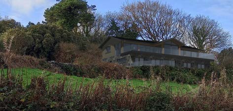
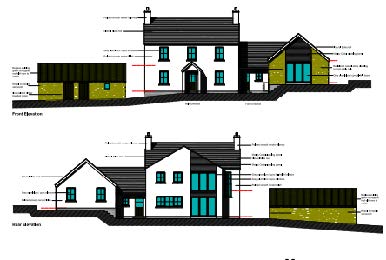
A photograph showing an existing stone farmhouse situated on a grassy hillside surrounded by trees and vegetation.A photograph showing a large detached house situated on a grassy slope surrounded by trees and vegetation.A colour photograph showing the exterior of a white, two-storey detached farmhouse with red window frames and a gravel driveway.The image displays architectural elevations of a proposed dwelling, showing both the front and rear views with dimension lines and annotations.
6.0 Summary
6.1 The existing building retains its habitable status by virtue of the history of its use and the fact that rates have been paid on it to date. The replacement of it may therefore be permitted provided that the building does not represent something of historic or architectural merit sufficient to outweigh this principle and the benefits of redevelopment in terms of thermal and energy efficiency and a more sensible layout which is conducive to both sets of occupants.
6.2 The farmhouse is certainly old although not as old as the main house which is in separate ownership and has been since at least 1939. It lacks any of the features of a traditional Manx house and within itself is inconsistent in terms of finish, window and door arrangements. Its attachment to the main house has lead to a complicated internal layout with a flying freehold and an internal wall built up within an existing window.
6.3 Ballashamrock House has historic interest but not as part of a semi-detached pair and the proposal to separate the two houses will reinstate the original character of the house as a detached dwelling in its own right.
6.4 The proposal will enable the farmhouse to be built to significantly higher standards of thermal and energy efficiency whilst remaining in contact with and part of the farm group. There is no agricultural worker’s occupancy condition attached to the existing farmhouse and none would be expected to be attached to any replacement as the principle of the replacement stands on its own merit in accordance with Housing Policies 12 and 14 although its location within the farmyard would most likely lead to an occupation with some association with the farm. Any replacement would be expected to comply with Housing Policy 14 in respect of size and design and conditions to this effect would be expected and acceptable.
6.5 It has been demonstrated that the demolition of the building would not result in any adverse impact on bats and the applicants would be happy to undertake the work outside of the main season as recommended by the Manx Bat Group. The demolition and new building would not encroach into any tree root protection area as the yard sits generally higher than the land to the south where the trees sit.
6.6 It is submitted that the proposal represents significant environmental improvement in a number of areas and complies with the relevant policies and the aspirations of the Climate Change Act and the Residential Design Guide as well as improving the living conditions of those in both the farmhouse and Ballashamrock House.
Sarah Corlett 03.11.2022
Appendix One - policies Strategic Plan General Policy 3: Development will not be permitted outside of those areas which are zoned for development on the appropriate Area Plan with the exception of:
(a) essential housing for agricultural workers who have to live close to their place of work; (Housing Policies 7, 8, 9 and 10);
(b) conversion of redundant rural buildings which are of architectural, historic, or social value and interest; (Housing Policy 11);
(c) previously developed land(1) which contains a significant amount of building; where the continued use is redundant; where redevelopment would reduce the impact of the current situation on the landscape or the wider environment; and where the development proposed would result in improvements to the landscape or wider environment;
(d) the replacement of existing rural dwellings; (Housing Policies 12, 13 and 14);
(e) location-dependent development in connection with the working of minerals or the provision of necessary services;
(f) building and engineering operations which are essential for the conduct of agriculture or forestry;
(g) development recognised to be of overriding national need in land use planning terms and for which there is no reasonable and acceptable alternative; and
(h) buildings or works required for interpretation of the countryside, its wildlife or heritage.
Environment Policy 1: The countryside and its ecology will be protected for its own sake. For the purposes of this policy, the countryside comprises all land which is outside the settlements defined in Appendix 3 at A.3.6 or which is not designated for future development on an Area Plan. Development which would adversely affect the countryside will not be permitted unless there is an over-riding national need in land use planning terms which outweighs the requirement to protect these areas and for which there is no reasonable and acceptable alternative.
Environment Policy 2: The present system of landscape classification of Areas of High Landscape or Coastal Value and Scenic Significance (AHLV’s) as shown on the 1982 Development Plan and subsequent Local and Area Plans will be used as a basis for development control until such time as it is superseded by a landscape classification which will introduce different categories of landscape and policies and guidance for control therein. Within these areas the protection of the character of the landscape will be the most important consideration unless it can be shown that:
(a) the development would not harm the character and quality of the landscape; or
(b) the location for the development is essential.
Environment Policy 3: Development will not be permitted where it would result in the unacceptable loss of or damage to woodland areas, especially ancient, natural and semi-natural woodlands, which have public amenity or conservation value.
Environment Policy 16: The use of existing rural buildings for new purposes such as tourist, or small-scale industrial/commercial use may be permitted where:
a) it is demonstrated that the building is no longer required for its original purpose and where the building is substantially intact and structurally capable of renovation;
b) the reuse of the building will result in the preservation of fabric which is of historic, architectural, or social interest or is otherwise of visual attraction;
c) it is demonstrated that the building could accommodate the new use without requiring extension or adverse change to appearance or character;
d) there would not be unacceptable implications in terms of traffic generation;
e) conversion does not lead to dispersal of activity on such a scale as to prejudice the vitality and viability of existing town and village services; and
f) the use of existing buildings involves significant levels of redevelopment to accommodate the new use, the benefits secured by the proposal in terms of impact on the environment and the rural economy shall outweigh the continued impact of retaining the existing buildings on site.
Proposals to convert rural buildings to residential accommodation will be considered along with the advice given at Section 8.10 of this document.
Housing Policy 11: Conversion of existing rural buildings into dwellings may be permitted, but only where:
(a) redundancy for the original use can be established;
(b) the building is substantially intact and structurally capable of renovation;
(c) the building is of architectural, historic, or social interest;
(d) the building is large enough to form a satisfactory dwelling, either as it stands or with modest, subordinate extension which does not affect adversely the character or interest of the building;
(e) residential use would not be incompatible with adjoining established uses or, where appropriate, land-use zonings on the area plan; and
(f) the building is or can be provided with satisfactory services without unreasonable public expenditure. Such conversion must:
(a) where practicable and desirable, re-establish the original appearance of the building; and
(b) use the same materials as those in the existing building. Permission will not be given for the rebuilding of ruins or the erection of replacement buildings of similar, or even identical, form.
Further extension of converted rural buildings will not usually be permitted, since this would lead to loss or reduction of the original interest and character.
Housing Policy 12: The replacement of an existing dwelling in the countryside will generally be permitted unless:
(a) the existing building has lost its residential use by abandonment; or
(b) the existing dwelling is of architectural or historic interest and is capable of renovation.
In assessing whether a property has lost its habitable status(1) by abandonment, regard will be had to the following criteria: (i) the structural condition of the building;
(ii) the period of non-residential use(2) or non-use in excess of ten years;
(iii) evidence of intervening use; and
(iv) evidence of intention, or otherwise, to abandon.
Housing Policy 13: In the case of those rural dwellings which have lost their former residential use by abandonment, consideration will be given in the following circumstances to the formation of a dwelling by use of the remaining fabric and the addition of new fabric to replace that which has been lost. Where:
a) the building is substantially intact; this will involve there being at least three of the walls, standing up to eaves level and structurally capable of being retained; and
b) there is an existing, usable track from the highway; and where
c) a supply of fresh potable water and of electricity can be made available from existing services within the highway.
(1) Habitable Status is defined in Appendix 1
(2) Non residential use is defined in Appendix 1 74 This policy will not apply in National Heritage Areas (see Environment Policy 6). Permission will not be given for the use of buildings more ruinous than those in (a) above, or for the erection of replacement buildings. Extensions of dwellings formed in accordance with the above may be permitted if the extension is clearly subordinate to the original building (i.e. in terms of floor space(3) measured externally, the extension measures less than 50% of that of the original).
8.11.2 It is important that replacement dwellings should relate closely to the buildings they replace in terms of siting and size, that the resulting visual impact is appropriate for the countryside, and that existing stone and slate are re-used.
Housing Policy 14: Where a replacement dwelling is permitted, it must not be substantially different to the existing in terms of siting and size, unless changes of siting or size would result in an overall environmental improvement; the new building should therefore generally be sited on the “footprint” of the existing, and should have a floor area(1), which is not more than 50% greater than that of the original building (floor areas should be measured externally and should not include attic space or outbuildings). Generally, the design of the new building should be in accordance with Policies 2- 7 of the present Planning Circular 3/91, (which will be revised and issued as a Planning Policy Statement). Exceptionally, permission may be granted for buildings of innovative, modern design where this is of high quality and would not result in adverse visual impact; designs should incorporate the re-use of such stone and slate as are still in place on the site, and in general, new fabric should be finished to match the materials of the original building.
Consideration may be given to proposals which result in a larger dwelling where this involves the replacement of an existing dwelling of poor form with one of more traditional character, or where, by its design or siting, there would be less visual impact.
Housing Policy 15: The extension or alteration of existing traditionally styled properties in the countryside will normally only be approved where these respect the proportion, form and appearance of the existing property. Only exceptionally will permission be granted for extensions which measure more than 50% of the existing building in terms of floor space (measured externally).
Appendix Two Landscape Character Assessment D13 - SANTON Key Characteristics
• A predominantly rural landscape, dissected by A5 and A25 roads.
• Densely wooded valley bottoms amongst undulating rolling land with large rectilinear arable and pastoral fields on the gently sloping hill sides and rounded tops.
• Steep sided densely wooded Victorian pleasure Glens of Glen Grenaugh and Port Soderick Glen lead down to the coast.
• Victorian electric railway line and stations runs through the area at the bottom of Crogga Glen.
• Fragmented woodland along field boundaries and along tracks that access the scattered farm houses centred around Quine’s Hill (along the A25) and small settlements of Santon and Ballaveare.
• Sea-facing hill slopes with large open fields running along the cliff tops with gorse, heather and bracken along the cliff top periphery.
• Incinerator chimney forms notable landmark in the immediate area.
• Presence of Manx Milestones.
• Abrupt linear southern built edge to Douglas, comprising residential and industrial development with minor localised extension of industrial character into character area south of Cooil Road.
• Pulrose Golf Course on edge of Douglas
Overall Character Description Numerous gentle to steeply sided river valleys cut down into the landform to form an undulating and rolling character with pronounced incised valleys. Glen Grenaugh and Port Soderick Glen are steepsided densely wooded valleys, the latter appropriated during the Victorian period as pleasure Glens with walkways and features such as bandstands and bridges. Linear fragmented woodland runs along the valley bottoms of these National Glens and along Crogga River. Hedgerow trees and woodland blocks surround the numerous farms in the area, which are predominantly located in the north of the area around Quine’s Hill.
Medium sized rectilinear arable and pastoral fields delineated predominantly by Manx hedges and some post and wire fences form a strong geometric field pattern on the gently sloping hill sides and rounded tops in the south of the area. Smaller rectilinear fields enclosed by Manx hedgerows, containing large hedgerow trees, cover the more settled north-eastern area where farmsteads such as Hampton Court and Cronkbane are concentrated. This field pattern stops abruptly in the north of the area where it meets the A24 and the linear built-up edge of Douglas. The far north-eastern part of the area comprises the Pulrose Golf Course, which extends in towards the centre of Douglas. Patches of gorse and heather grow in areas on the more exposed hill tops and along the eastern edges of the fields of the coastal facing slopes, along which the cliff top coastal path runs and forms the area’s seaward boundary.
The busy A25 runs along the lower valley sides with small, often steep and winding tracks branching off perpendicular from the main road to provide farm access, while smaller predominantly straight B roads, enclosed by tall hedgerow vegetation, which follow the grain of the rectilinear field pattern and link the small and wooded settlements within the area such as Santon and Seafield. The Victorian Electric Railway runs through the area along Crogga Glen with stations at Santon and Port Soderick before skirting around the bottom of Douglas Head which forms the north eastern boundary. Moderate sense of tranquillity away from Douglas and the major roads.
Key Views
• Open and expansive views from the higher areas along the rugged coast in the east and inland towards the upland areas over Braaid.
• Incinerator chimney forms a notable landmark in the immediate area.
• Glimpsed views framed by vegetation in the valley bottoms and along the main roads where they follow the wooded valley bottoms.
• Views in the northern part of the area up to the Transmitting Masts on top of Douglas Head hill top.
• Views from Isle of Man Steam Railway Historic Features
• Victorian Isle of Man Steam Railway and stations, including Port Soderick (Registered Building) and the Old Toll Booth (Registered Building). Ecological Features
• Farmland grassland habitats.
• Mature network of hedgerows containing deciduous trees in field boundaries.
• Aquatic and waterside habitats along river courses.
• Dense riparian woodland in Valley bottom with deciduous woodland along valley sides.
• Exposed heathland on steeper sea facing slopes. Key Issues and landscape sensitivities
• Wooded horizons and skyline seen from valley bottoms.
• Ecological value of the aquatic and waterside habitats.
• Various sized pastoral and arable fields with Manx hedges.
• Wooded valley bottom with fragmented woodland along substantial field boundaries.
• Scattered farmsteads fringed by trees.
• Wooded Victorian Pleasure Glen at Port Soderick.
• Victorian Isle of Man Steam Railway and stations.
• Presence of Manx Milestones.
∫ The overall strategy should be to conserve and enhance the character, quality and distinctiveness of the area, with its wooded valley bottoms and wooded horizons, its scattered settlement pattern, its Victorian pleasure glen and the railway.
Appendix Three - Climate Change Act 2021
6 Town and Country Planning Act 1999 amended In the Town and Country Planning Act 1999 —
(a) after section 2(2) (development plan) insert —
(2AA)The development plan must also take into account the following climate change policies established under the Climate Change Act 202- —
(a) the maximisation of carbon sequestration;
(b) the minimising of greenhouse gas emissions;
(c) the maintenance and restoration of ecosystems;
(d) biodiversity net gain;
(e) the need for sustainable drainage systems; and
(f) the provision of active travel infrastructure.
(b) after section 2A(1) (national policy directives) insert —
(1A) A national policy directive or a development plan must be issued before 1 January 2025 that takes into account the following climate change policies established under the Climate Change Act 202- —
(a) the maximisation of carbon sequestration;
(b) the minimising of greenhouse gas emissions;
(c) the maintenance and restoration of ecosystems;
(d) biodiversity net gain;
(e) the need for sustainable drainage systems; and
(f) the provision of active travel infrastructure;
(c) after section 6(3)(d) (meaning of “development”) insert —
(da) the removal or blocking of drainage in peatland (as defined in the Forestry Act 1984 and the restoration of peatland by the Department
7 Town and Country Planning (Development Procedure) Order 2019 amended After paragraph 2 of Schedule 1 to the Town and Country Planning (Development Procedure) Order 2019, insert —
2A All applications except those for approval for change of use, reserved matters, replacement windows and doors in conservation areas and minor changes
(1) This paragraph applies to applications for planning approval except those referred to in subparagraph (2).
(2) This paragraph does not apply to —
(a) an application for change of use only;
(b) an application for approval of reserved matters;
(c) an application to replace a window or a door of a building in a conservation area; and
(d) a minor changes application.
(3) Every application to which this paragraph applies must —
(a) demonstrate that the application has been made having regard to the following climate change policies established under the Climate Change Act 202- —
(i) the maximisation of carbon sequestration;
(ii) the minimising of greenhouse gas emissions;
(iii) the maintenance and restoration of ecosystems;
(iv) biodiversity net gain;
(v) the need for sustainable drainage systems; and
(vi) the provision of active travel infrastructure; or
(b) explain why consideration of one or more of those polices is not practicable in relation to the proposed development.
Copyright in submitted documents remains with their authors. Request removal
Source & Provenance
Official reference
22/01373/A
Source authority
Isle of Man Government Planning & Building Control