PLANNING STATEMENT TO SUPPORT AN APPLICATION FOR THE PRINCIPLE OF THE ERECTION OF FOUR DWELLINGS WITH DETAILS OF ACCESS, RESERVING MATTERS OF DESIGN, APPEARANCE, LAYOUT, DRAINAGE, LANDSCAPING AT THE AUBURNS, LEZAYRE ROAD, RAMSEY
1.0 Introduction
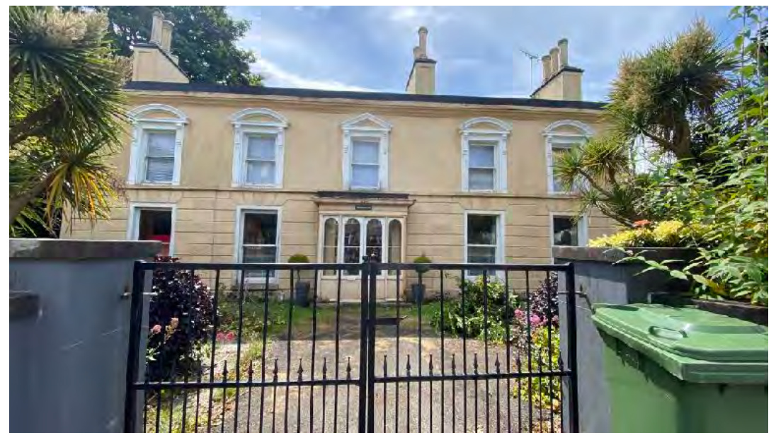
1.1 The Auburns is a detached building which sits on the southern side of Lezayre Road (TT Course) between Parliament Square and Bircham Avenue.
Sarah Corlett Town Planning Consultancy Ltd Registered address: Ballachrink Croft, Ballacorey Road, Bride, Isle of Man IM7 4AW t: 07624 485517 e: [email protected] w: www.sarahcorlett.com Directors: Sarah Elizabeth Corlett Nicola Jane Corlett
Company Registration 134325C
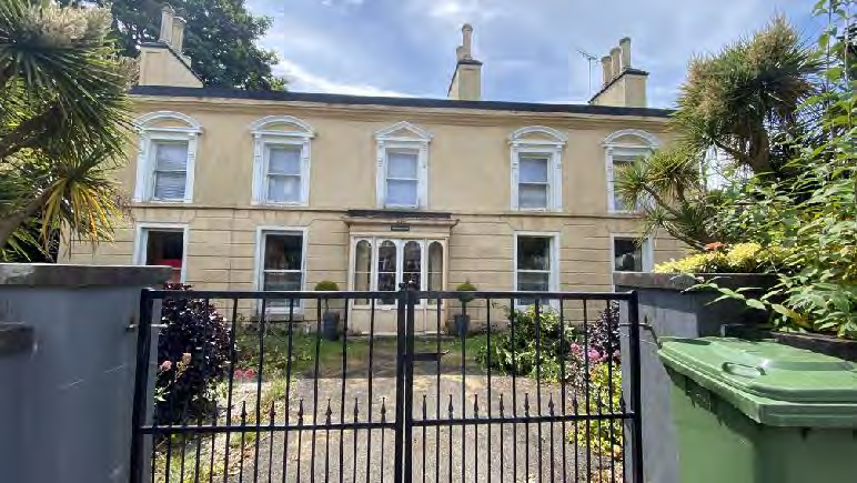
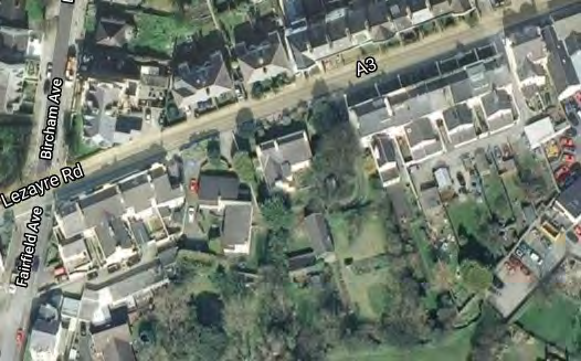
A street-level photograph of a large, two-story cream-colored terraced house with white window frames and a black metal gate in the foreground.A photograph showing the front exterior of a large, two-story cream-colored house with a black metal gate and gravel driveway.An aerial view showing a residential area with visible road names like Lezayre Rd and Bircham Ave, serving as a location map for the proposed development.
1.2 The building, The Auburns, sits slightly off centre within the plot, to the south west, and towards the front of the plot, observing the building line of the terraces to the north east and south west. The Auburns sits slightly further back than these, with 7.5m between the frontage of the building and the back of the footpath, with the terrace to the north east being between 6-6.5 from the highway and Altdale Terrace to the south west being closer, at around 4m from the highway. Between The Auburns and Altdale Terrace, sits The Oaks, a much newer dwelling which sits at an angle to the highway and slightly further back than is The Auburns.
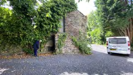
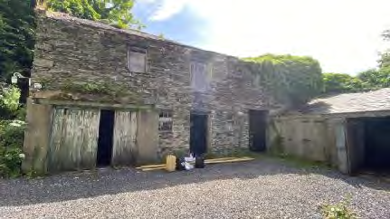
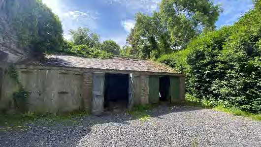
1.3 Also within the site is a stone outbuilding which sits to the rear of the house. This is Lshaped and two storeys in height.
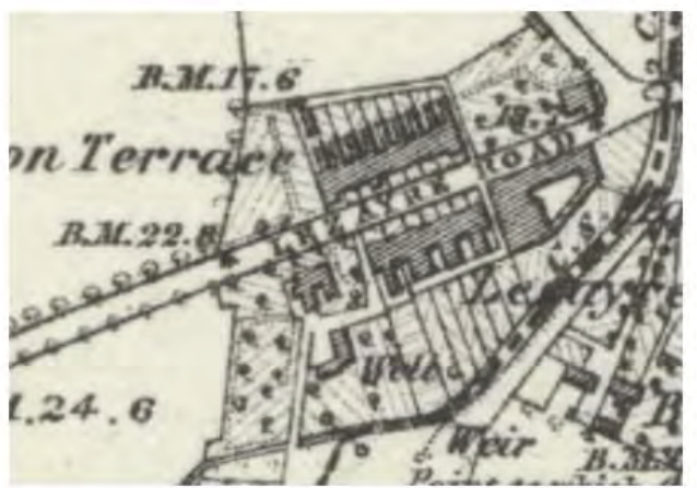
1.4 Both The Auburns (albeit in a different format - with different rear annexes) and the outbuilding appear on the 1860s County Series mapping and appear to mark the western extent of Ramsey at this time:
Sarah Corlett Town Planning Consultancy Ltd Registered address: Ballachrink Croft, Ballacorey Road, Bride, Isle of Man IM7 4AW t: 07624 485517 e: [email protected] w: www.sarahcorlett.com Directors: Sarah Elizabeth Corlett Nicola Jane Corlett
Company Registration 134325C
A photograph showing a stone building partially covered in ivy next to a gravel driveway with a white van parked nearby and a person standing by the wall.A photograph showing a large, weathered stone building with multiple wooden doors, resembling a barn or agricultural outbuilding on a gravel site.A photograph showing a small, detached outbuilding or garage with a tiled roof and green doors, located on a gravel driveway surrounded by dense vegetation.
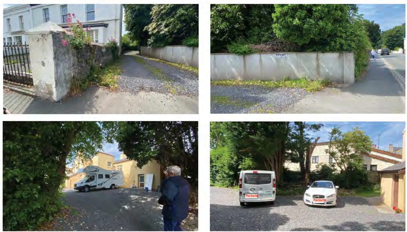
1.5 Vehicular access into the property exists via a driveway which sits to the north east of the house although there is pedestrian access directly in front of the house. The driveway runs along the north western side of the house, past some mature, tall trees and there is car parking space between the rear of the house and the outbuilding.
1.6 The house has long been used as two dwellings with one front entrance door which divides into two in the foyer, leading to two separate units of accommodation. Each has separate services.
A cropped section of a historical topographical map showing buildings, roads, and a weir in the Lezayre area.A collage of four photographs illustrating the site's existing access points, boundary walls, and current driveway parking arrangements.
1.7 The watercourse, Strooan ny Crawe runs to the rear of the property from Ramsey Golf Course to discharge into the harbour. This watercourse becomes culverted at the north eastern corner of the Lheighany Playing Fields.
2.0 Planning status
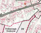
2.1 The site lies within an area designated on the Ramsey Local Plan of 1998 as Predominantly Residential.
2.2 One of the trees on the site was recently (22.2.22) Registered (RT1173). There are no Registered Buildings on the site and it does not lie within a proposed or adopted Conservation Area.
2.3 The land to the rear of the house lies within an area at high risk of tidal and river flooding on the national flood risk mapping:
2.4 Area Plan for the north and west 2.4.1 The Cabinet Office is in the process of preparing an Area Plan for the north and west of the Island which includes Ramsey and will ultimately replace the Ramsey Local Plan and all of the other local plans and the Isle of Man Planning Scheme (Development Plan) Order 1982 for the study area. This Area Plan is in its early stages of preparation but the general approach to land use allocation and the need for development land has been set out and includes the following statement by Cabinet Office:
Sarah Corlett Town Planning Consultancy Ltd Registered address: Ballachrink Croft, Ballacorey Road, Bride, Isle of Man IM7 4AW t: 07624 485517 e: [email protected] w: www.sarahcorlett.com Directors: Sarah Elizabeth Corlett Nicola Jane Corlett
Company Registration 134325C
A close-up view of a site plan or location map showing property boundaries marked in red and text indicating 'Predominantly Residential' land use.This image displays a close-up section of a location map or site plan. It features street names such as 'Auburn Place' and surrounding green areas, indicating the site's location within the parish.
Table 5: Outside of Douglas, development will be concentrated on Service Centres (Peel and Ramsey) to provide regeneration and choice of location for housing, employment and services.
3.5 General approach to the location of new development in the North and West So, at this point, the approach that will be followed for the Draft Plan for North and West is that any land that is required for housing and employment which are the most land hungry uses will be generally focused in and on the edge of Ramsey and Peel as sustainable urban extensions. They are recognised in the Settlement Hierarchy as being Service Centres. The impact of this approach on lower order centres will of course be examined as the plan develops.
3.6.3 On Settlement Pattern
3.6.4 A development model based upon urban expansion provides a good opportunity to maximise the amount of development that takes place on brownfield land that is located within existing settlement boundaries.
3.6.5 Urban sites can have more constraints such as an increased risk of flooding.
3.6.6 Grey Infrastructure
3.6.7 Examining grey infrastructure includes looking at the road network and general patterns of coverage for bus services. Ramsey has good links to settlements in the east and west. Likewise, Peel to Ramsey and Douglas. Public transport serving lower order settlements in the north is provided on a less frequent basis. Consideration will need to be given at an individual site stage to the impact of development on roads and services and other utilities. In the east, the Active Travel Strategy played a key role in identifying sites and will be sure to play an important role for the North and west as will other ‘smarter movement’ strategies emerging from the Department for Infrastructure.
3.6.8 Recent growth in the North has resulted in a new sewage treatments works at Balladoole, to the north of Ramsey and its capacity going forward will be an important factor in site assessment. Recent growth patterns in Peel and the surrounding settlements have led to a decision to invest in a new sewage treatment works within the West. This is evidenced in the recently submitted planning application for a new sewage treatment works at Glenfaba House in Peel and the planning process and outcome (refused) is evidence that wherever possible, such infrastructure should be planned into an area plan when possible.
3.6.9 Regard will be had to the National Infrastructure Strategy in the preparation of the Draft Plan.
3.6.17 In terms of facilities, both Ramsey and Peel have Swimming Pools which offer excellent local facilities and go some way in providing an alternative to the NSC but the Douglas facility does draw users from across the Island as a whole.
Sarah Corlett Town Planning Consultancy Ltd Registered address: Ballachrink Croft, Ballacorey Road, Bride, Isle of Man IM7 4AW t: 07624 485517 e: [email protected] w: www.sarahcorlett.com Directors: Sarah Elizabeth Corlett Nicola Jane Corlett
Company Registration 134325C
Summary - Chapter 3
1. New development will be directed toward settlements in the settlement hierarchy with a focus on the Service Centres of Ramsey and Peel.
2. Development is not ruled out in the Service Villages and Villages but is likely to be low key especially given the low level of housing opportunities that need to be found up to 2026.
3. Previous scenario testing exercises and recent Plan outcomes demonstrate the need to look carefully at the capacity of our existing settlements - to make the best use of our urban spaces - which can help ensure new development has access to services and facilities. (Main Consultation Document Paper No. PP1)
2.4.2 The draft Area Plan for the North and West was published in June, 2022 and the land use map for this area continues the residential land use designation of the local plan. The Environmental Constraints map accompanying the draft Area Plan does not identify any constraints appertaining to this site: the infrastructural constraints map identifies part of the site and the land to the east and south as of high risk of tidal flooding but not tidal and river flooding as was noted in the earlier flood risk information (see above).
2.5 Strategic Plan
2.5.1 The Strategic Plan is based upon the principles of sustainable development where new building is directed towards existing settlements and where optimisation of the use of land is encouraged:
Strategic Aim: To plan for the efficient and effective provision of services and infrastructure and to direct and control development and the use of land to meet the community’s needs, having particular regard to the principles of sustainability whilst at the same time preserving, protecting, and improving the quality of the environment, having particular regard to our uniquely Manx natural, wildlife, cultural and built heritage.
Strategic Policy 1: Development should make the best use of resources by:
(a) optimising the use of previously developed land, redundant buildings, unused and under-used land and buildings, and reusing scarce indigenous building materials;
(b) ensuring efficient use of sites, taking into account the needs for access, landscaping, open space(1) and amenity standards; and
(c) being located so as to utilise existing and planned infrastructure, facilities and services.
Sarah Corlett Town Planning Consultancy Ltd Registered address: Ballachrink Croft, Ballacorey Road, Bride, Isle of Man IM7 4AW t: 07624 485517 e: [email protected] w: www.sarahcorlett.com Directors: Sarah Elizabeth Corlett Nicola Jane Corlett
Company Registration 134325C
A low-resolution digital map showing a green rural landscape with roads and a highlighted pink plot area.
Strategic Policy 2: New development will be located primarily within our existing towns and villages, or, where appropriate, in sustainable urban extensions(2) of these towns and villages. Development will be permitted in the countryside only in the exceptional circumstances identified in paragraph 6.3.
Spatial Policy 2: Outside Douglas development will be concentrated on the following Service Centres to provide regeneration and choice of location for housing, employment and services…Ramsey… Area Plans will define the development boundaries of such centres so as to provide a range of housing and employment opportunities at a scale appropriate to the settlement.
Spatial Policy 5: New development will be located within the defined settlements. Development will only be permitted in the countryside in accordance with General Policy 3.
Housing Policy 4: New housing will be located primarily within our existing towns and villages, or, where appropriate, in sustainable urban extensions(1) of these towns and villages where identified in adopted Area Plans: otherwise new housing will be permitted in the countryside only in the following exceptional circumstances:
(a) essential housing for agricultural workers in accordance with Housing Policies 7, 8, 9 and 10;
(b) conversion of redundant rural buildings in accordance with Housing Policy 11; and
(c) the replacement of existing rural dwellings and abandoned dwellings in accordance with Housing Policies 12, 13 and 14. 2.5.2 There are also policies which provide guidance on new development:
Strategic Policy 3: Proposals for development must ensure that the individual character of our towns and villages is protected or enhanced by…(b) having regard in the design of new development to the use of local materials and character.
Strategic Policy 4: Proposals for development must … (b) protect or enhance the landscape quality and nature conservation value of urban as well as rural areas but especially in respect to development adjacent to Areas of Special Scientific Interest and other designations; and (c) not cause or lead to unacceptable environmental pollution or disturbance.
Strategic Policy 5: New development, including individual buildings, should be designed so as to make a positive contribution to the environment of the Island. In appropriate cases the Department will require planning applications to be supported by a Design Statement which will be required to take account of the Strategic Aim and Policies.
Sarah Corlett Town Planning Consultancy Ltd Registered address: Ballachrink Croft, Ballacorey Road, Bride, Isle of Man IM7 4AW t: 07624 485517 e: [email protected] w: www.sarahcorlett.com Directors: Sarah Elizabeth Corlett Nicola Jane Corlett
Company Registration 134325C
Strategic Policy 10: New development should be located and designed such as to promote a more integrated transport network with the aim to:
(a) minimise journeys, especially by private car;
(b) make best use of public transport;
(c) not adversely affect highway safety for all users, and
(d) encourage pedestrian movement.
General Policy 2: Development which is in accordance with the land-use zoning and proposals in the appropriate Area Plan and with other policies of this Strategic Plan will normally be permitted, provided that the development:
(a) is in accordance with the design brief in the Area Plan where there is such a brief;
(b) respects the site and surroundings in terms of the siting, layout, scale, form, design and landscaping of buildings and the spaces around them;
(c) does not affect adversely the character of the surrounding landscape or townscape;
(d) does not adversely affect the protected wildlife or locally important habitats on the site or adjacent land, including water courses;
(e) does not affect adversely public views of the sea;
(f) incorporates where possible existing topography and landscape features, particularly trees and sod banks;
(g) does not affect adversely the amenity of local residents or the character of the locality;
(h) provides satisfactory amenity standards in itself, including where appropriate safe and convenient access for all highway users, together with adequate parking, servicing and manoeuvring space;
(i) does not have an unacceptable effect on road safety or traffic flows on the local highways;
(j) can be provided with all necessary services;
(k) does not prejudice the use or development of adjoining land in accordance with the appropriate Area Plan;
(l) is not on contaminated land or subject to unreasonable risk of erosion or flooding;
(m) takes account of community and personal safety and security in the design of buildings and the spaces around them; and
(n) is designed having due regard to best practice in reducing energy consumption.
Housing Policy 5: In granting planning permission on land zoned for residential development or in predominantly residential areas the Department will normally require that 25% of provision should be made up of affordable housing. This policy will apply to developments of 8 dwellings or more.
Housing Policy 6: Development of land which is zoned for residential development must be undertaken in accordance with the brief in the relevant
Sarah Corlett Town Planning Consultancy Ltd Registered address: Ballachrink Croft, Ballacorey Road, Bride, Isle of Man IM7 4AW t: 07624 485517 e: [email protected] w: www.sarahcorlett.com Directors: Sarah Elizabeth Corlett Nicola Jane Corlett
Company Registration 134325C
area plan, or, in the absence of a brief, in accordance with the criteria in paragraph 6.2 of this Plan. Briefs will encourage good and innovative design, and will not be needlessly prescriptive.
Recreation Policy 3: Where appropriate, new development should include the provision of landscaped amenity areas as an integral part of the design. New residential development of ten or more dwellings must make provision for recreational and amenity space in accordance with the standards specified in Appendix 6 to the Plan.
Transport Policy 1: New development should, where possible, be located close to existing public transport facilities and routes, including pedestrian, cycle and rail routes.
Transport Policy 4: The new and existing highways which serve any new development must be designed so as to be capable of accommodating the vehicle and pedestrian journeys generated by that development in a safe and appropriate manner, and in accordance with the environmental objectives of this plan.
Transport Policy 7: The Department will require that in all new development, parking provision must be in accordance with the Department’s current standards. Typical residential standard is 2 spaces per unit, at least one of which is retained within the curtilage and behind the front of the dwelling.
2.5.3 Policies which provide caution over certain sensitive elements of the townscape are as follows:
Environment Policy 4: Development will not be permitted which would adversely affect:
(a) species and habitats of international importance:
(i) protected species of international importance or their habitats; or
(ii) proposed or designated Ramsar and Emerald Sites or other internationally important sites.
(b) species and habitats of national importance:
(i) protected species of national importance or their habitats;
(ii) proposed or designated National Nature Reserves, or Areas of Special Scientific Interest; or
(iii) Marine Nature Reserves; or
(iv) National Trust Land.
(c) species and habitats of local importance such as Wildlife Sites, local nature reserves, priority habitats or species identified in any Manx Biodiversity Action Plan which do not already benefit from statutory protection, Areas of Special
Sarah Corlett Town Planning Consultancy Ltd Registered address: Ballachrink Croft, Ballacorey Road, Bride, Isle of Man IM7 4AW t: 07624 485517 e: [email protected] w: www.sarahcorlett.com Directors: Sarah Elizabeth Corlett Nicola Jane Corlett
Company Registration 134325C
Protection and Bird Sanctuaries and landscape features of importance to wild flora and fauna by reason of their continuous nature or function as a corridor between habitats.
Some areas to which this policy applies are identified as Areas of Ecological Importance or Interest on extant Local or Area Plans, but others, whose importance was not evident at the time of the adoption of the relevant Local or Area Plan, are not, particularly where that plan has been in place for many years. In these circumstances, the Department will seek site specific advice from the Department of Agriculture, Fisheries and Forestry if development proposals are brought forward.
Environment Policy 10: Where development is proposed on any site where in the opinion of the Department of Local Government and the Environment there is a potential risk of flooding, a flood risk assessment and details of proposed mitigation measures must accompany any application for planning permission. The requirements for a flood risk assessment are set out in Appendix 4.
Environment Policy 13: Development which would result in an unacceptable risk from flooding, either on or off-site, will not be permitted.
Environment Policy 42: New development in existing settlements must be designed to take account of the particular character and identity, in terms of buildings and landscape features of the immediate locality. Inappropriate backland development, and the removal of open or green spaces which contribute to the visual amenity and sense of place of a particular area will not be permitted. Those open or green spaces which are to be preserved will be identified in Area Plans.
2.6 Ramsey Local Plan Written Statement 2.6.1 As well as providing a land use designation map, there is also a Written Statement which accompanies the maps of the adopted Ramsey local Plan and which provides supplementary information to guide new development. The following is considered relevant although in principle there is an inherent challenge to reconcile this with Strategic Policy 1 and perhaps Environment Policy 42 is a more appropriate policy to consider in the matter of backland development:
Policy R/R/P3: Infill/Backland sites Within areas zoned for Predominantly Residential use there will be a general presumption against the development of those sites which provide attractive, natural “breathing”spaces between established residential buildings. These sites will often include trees, mature landscaping or simple green space. Any possible development of such sites should form the subject of consultation with the Office of Planning prior to the submission of any application.
Sarah Corlett Town Planning Consultancy Ltd Registered address: Ballachrink Croft, Ballacorey Road, Bride, Isle of Man IM7 4AW t: 07624 485517 e: [email protected] w: www.sarahcorlett.com Directors: Sarah Elizabeth Corlett Nicola Jane Corlett
Company Registration 134325C
Policy R/E/P3: Backland Development and Development in the Grounds of Houses There shall be a general presumption against backland development and development within the grounds of large houses on those sites which are well landscaped within [sic] ample tree coverage.
2.7 Manual for Manx Roads
2.7.1 This document sets out standards and guidance on new development in respect of new roads, accesses, visibility splays and car parking. It is intended to supplement, not replace the standards within the Strategic Plan and its contents should be taken into account in the design of new residential development.
2.8 Residential Design Guidance (RDG)
2.8.1 This provides guidance on the design of new housing as well as clarification on how the impact of new development will affect the living conditions of those in adjacent dwellings. It also refers to Design Statements, suggesting that:
a design statement provides an opportunity for the applicant to explain how they have considered a Sustainable Construction approach (see Chapter 2.0) responded to the need to: maximize carbon sequestration; minimize greenhouse gas emissions; maintain and enhance ecosystems; achieve biodiversity net gain; provide sustainable drainage systems; and provide active travel and public transport infrastructure
2.8.2 There is a whole section on sustainable construction and any application needs to demonstrate what has been taken into account in this respect in the design and layout.
2.8.3 It also refers to environmental enhancement encouraging development to result in a net gain in biodiversity and the creation of “pleasant, healthy, safe and inclusive spaces”. It encourages “local distinctiveness” and good quality design which respects the nature of the development site and the character of the neighbouring buildings and surrounding area. The Design Statement should explain how the development complies with this.
2.8.4 It helpfully reinforces the desire for optimising the use of unused and under-used land, stating that the change of use of Greenfield land to developed can significantly contribute to greenhouse gas emissions, preferring the development of brownfield land but warning that developments should be fit for purpose. It refers to town centre development having a density of 40-100 houses per hectare (high) and where this is typically terraced or apartment housing. Sites close to the settlement centre including apartments and terraced housing being 15-30 houses per hectare and “large sites towards the edge of settlements” being 5-10 dwellings per hectare. It specifically says that “it is important to facilitate development which allows the reuse of previously developed land and/or the reuse of these buildings (paragraph 3.7.2) adding, “it is acknowledged that sometimes a pragmatic approach may need to be taken in applying policies and standards to enable this reuse to occur” (paragraph 3.7.2).
Sarah Corlett Town Planning Consultancy Ltd Registered address: Ballachrink Croft, Ballacorey Road, Bride, Isle of Man IM7 4AW t: 07624 485517 e: [email protected] w: www.sarahcorlett.com Directors: Sarah Elizabeth Corlett Nicola Jane Corlett
Company Registration 134325C
2.8.5 Sections 4 and 7 discuss the 45 degree and 25 degree approach to assessing the impact of new buildings on the outlook and privacy of those in neighbouring properties. The application should demonstrate how these standards are met. These standards will need to be met within the development as well as in terms of those houses alongside the site.
2.9 General planning guidance
2.9.1 Newly issued planning guidance focuses on the need for sustainable construction and clarification of how this will be achieved in any new development.
3.0 Planning History
3.1 The site has been the subject of the following applications:
88/01273/A - approval in principle for dwelling and garage, to the rear of The Auburns approved
89/01975/A approval in principle for the erection of dwelling with garage, to the rear of The Auburns - refused 03/00669/A - approval in principle for the erection of dwelling and garage - approved
06/01369/REM - reserved matters application for the erection of dwelling and garage approved: this included a flood bund at the rear which has been constructed and is in situ
07/01058/B - alterations and conversion of barn to a dwelling - approved 19/00778/B - conversion and extension of barn to create a residential dwelling - approved and will expire on 07.10.23.
4.0 The proposal
4.1 Proposed is the principle of the development of the land to the rear of The Auburns, including the demolition of the existing outbuilding (works for which planning approval is not required) for four dwellings and the associated drainage, access and overall landscaping, tree protection and flood risk prevention works.
4.2 The application includes existing and proposed site plans which demonstrate how the site could be set out to accommodate four dwellings although other layouts are possible. The suggested layout demonstrates that four dwellings may be accommodated on the site along with the required car parking and private amenity space and so that there is no adverse impact on those in adjacent properties using the distances and measurements in the RDG. Drainage
4.3 Drainage will be provided, discharging foul sewerage to the combined sewer in Lezayre Road (shown on the drawings) and surface water to either the nearest watercourse subject to the appropriate discharge licence or soakaways, dependent upon the nature of the ground. Flood risk
4.4 A Flood Risk Assessment (FRA) is provided which confirms the status of the site as being at risk of flooding, noting the national flood risk maps which shows the site at risk of tidal
Sarah Corlett Town Planning Consultancy Ltd Registered address: Ballachrink Croft, Ballacorey Road, Bride, Isle of Man IM7 4AW t: 07624 485517 e: [email protected] w: www.sarahcorlett.com Directors: Sarah Elizabeth Corlett Nicola Jane Corlett
Company Registration 134325C
and fluvial flooding (see paragraph 2.4.2 above). It states that the latest predicted level has been requested from the Flood Hub but no response has been received to date. The report anticipates a ground floor level of any house to be 600mm above whatever the predicted flood level may be. It also confirms that the development will be designed to acknowledge the flood risk, incorporating measures to ensure that the users of the site will be safe in the event of any flood. Drainage will be installed with valves to prevent the back flow of waste water into the properties should a flood occur as will the surface water stream discharge pipe and it may be that soakaways may be utilised should the ground be found to be suitable. There is a paved route out of the site should occupants wish or need to leave in the event of a flood. Full details and a more comprehensive coverage of these issues is contained in the FRA.
Access
4.5 Access to the new properties will utilise the existing access which has available to it, visibility splays onto Lezayre Road of 2.4m by over 60m to the south west and 2.4m by over 37m to the north east.
4.6 The works propose to widen the entrance to enhance visibility and manoeuvring space for vehicles entering and leaving the site and also to accommodate space for refuse bins to be kept on collection day: they will not be stored there permanently. None of these works will involve the Root Protection Area (RPA) of any adjacent tree. Biodiversity enhancement
4.7 The applicants will contact the Manx Bat Group prior to the demolition of the barn to ensure that there is no harm to this protected species and will ensure that there are no nesting birds, in compliance with the Wildlife Act 1990 although it should be noted that planning approval is not required for the demolition of the building.
4.8 There is also the opportunity for the introduction of local flora which support biodiversity as replacements for those trees which need to be removed due to their presently health. Tree protection
4.9 A tree report is provided in the acknowledgment of the registered status of one of the existing trees on the site and the importance, generally, of trying to retain existing trees of amenity value. RPAs are shown for all of the existing trees on site and the majority will be retained although it should be noted, as stated in the Tree Report, that many of these are ash and are suffering from ash dieback and their longer term future is not secure and indeed they need to be removed (17 ash trees and a further sycamore and holly which are also in poor condition) and would benefit from being removed, irrespective of any development proposals. The development can be undertaken without the need for the removal of any trees of amenity value and which are healthy and trees, particularly those on the boundary with other residential property may be retained as long as is practical and replaced if not.
Sarah Corlett Town Planning Consultancy Ltd Registered address: Ballachrink Croft, Ballacorey Road, Bride, Isle of Man IM7 4AW t: 07624 485517 e: [email protected] w: www.sarahcorlett.com Directors: Sarah Elizabeth Corlett Nicola Jane Corlett
Company Registration 134325C
5.0 Conclusion
5.1 The site is designated for residential development and is highly sustainable - close to the town centre and sustainable modes of transport so the principle of the development of more dwellings on this site should be considered to be in accordance with the sustainability policies identified above and the newly emerging Area Plan for the North and West.
5.2 The potential constraints on development include concern about the loss of the existing outbuildings, flood risk, highway safety, impact on trees and ecology and impact on the living conditions of those in neighbouring properties. It is highly relevant in the consideration of all of these issues, that planning approval has been granted previously (and one remains capable of implementation) for additional development on this site. What is proposed increases the density of this additional development which is more supportive of the policies which support optimising the use of sustainable and under-used sites.
5.3 The flood risk to the site at present has already been mitigated by new bund at the rear which will prevent floodwater from the watercourse coming into the site. From the front, mitigating the ingress of flood water from Lezayre Road, as shown as being a risk on the national flood risk maps can be undertaken locally by the use of sand bags or other temporary measures as do other properties along Lezayre Road although as stated above, the proposed properties will raised in level appropriate to the predicted flood level.
5.4 Highway safety is not considered to be an issue given the planning history of the site and is demonstrated in the submitted plans that that a safe means of access is available and sufficient width of internal roads for the turning and access of the vehicles which will use the site including passing places. Bins may be stored temporarily (on collection days) at the entrance so that refuse vehicles need not enter the site.
5.5 The development will not adversely affect any trees of amenity value and new landscaping will be introduced as part of the development and could demonstrate no negative biodiversity net effect.
5.6 Unacceptable backland development is presumed against but in this case, we would suggest that whilst the new housing is to be built to the rear of the existing dwellings in The Auburns, the access is to the side and there is ample separation between the rear of The Auburns and the closest part of any of the new houses to protect the amenities of all and sensitivity and the guidance in the RDG will be observed in terms of the placement of any windows which may look towards existing adjacent property. In addition, it is relevant that planning approval has been granted (and remains capable of implementation) for the creation of new housing to the rear through the conversion of the existing barn and also the erection of a completely new dwelling albeit that this approval has expired. This current proposal optimises the use of the site through an increase in density and reduction in the size of each unit compared with the previous and current approvals on the site.
Sarah Corlett Town Planning Consultancy Ltd Registered address: Ballachrink Croft, Ballacorey Road, Bride, Isle of Man IM7 4AW t: 07624 485517 e: [email protected] w: www.sarahcorlett.com Directors: Sarah Elizabeth Corlett Nicola Jane Corlett
Company Registration 134325C
5.7 It is considered that the proposed development optimises the use of this highly sustainable site whilst providing a development which provides satisfactory amenities for the occupants of the proposed dwellings and whilst not adversely affecting the amenities of those in adjacent property and without adversely affecting the character and contribution The Auburns makes to the streetscene, in full accordance with all of the relevant policies listed above.
Sarah Corlett 23.09.22
Sarah Corlett Town Planning Consultancy Ltd Registered address: Ballachrink Croft, Ballacorey Road, Bride, Isle of Man IM7 4AW t: 07624 485517 e: [email protected] w: www.sarahcorlett.com Directors: Sarah Elizabeth Corlett Nicola Jane Corlett
Company Registration 134325C
Copyright in submitted documents remains with their authors. Request removal
Source & Provenance
Official reference
22/01212/A
Source authority
Isle of Man Government Planning & Building Control