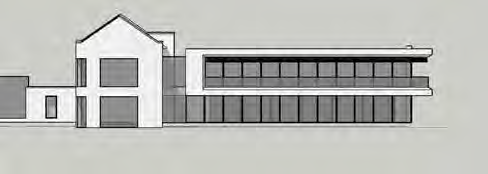
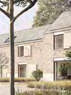
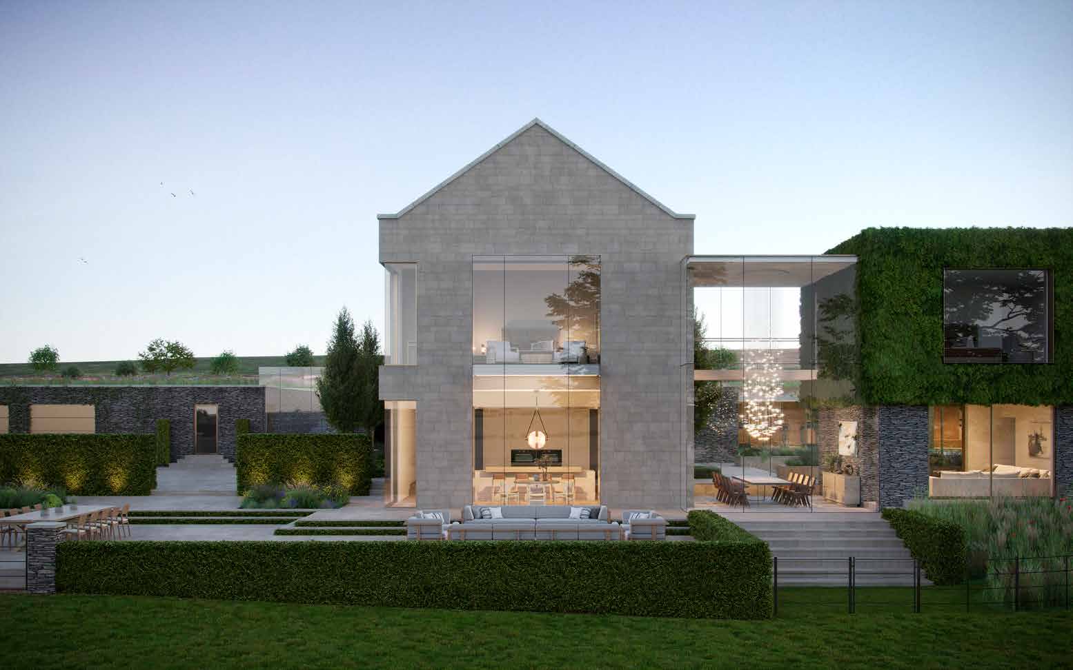
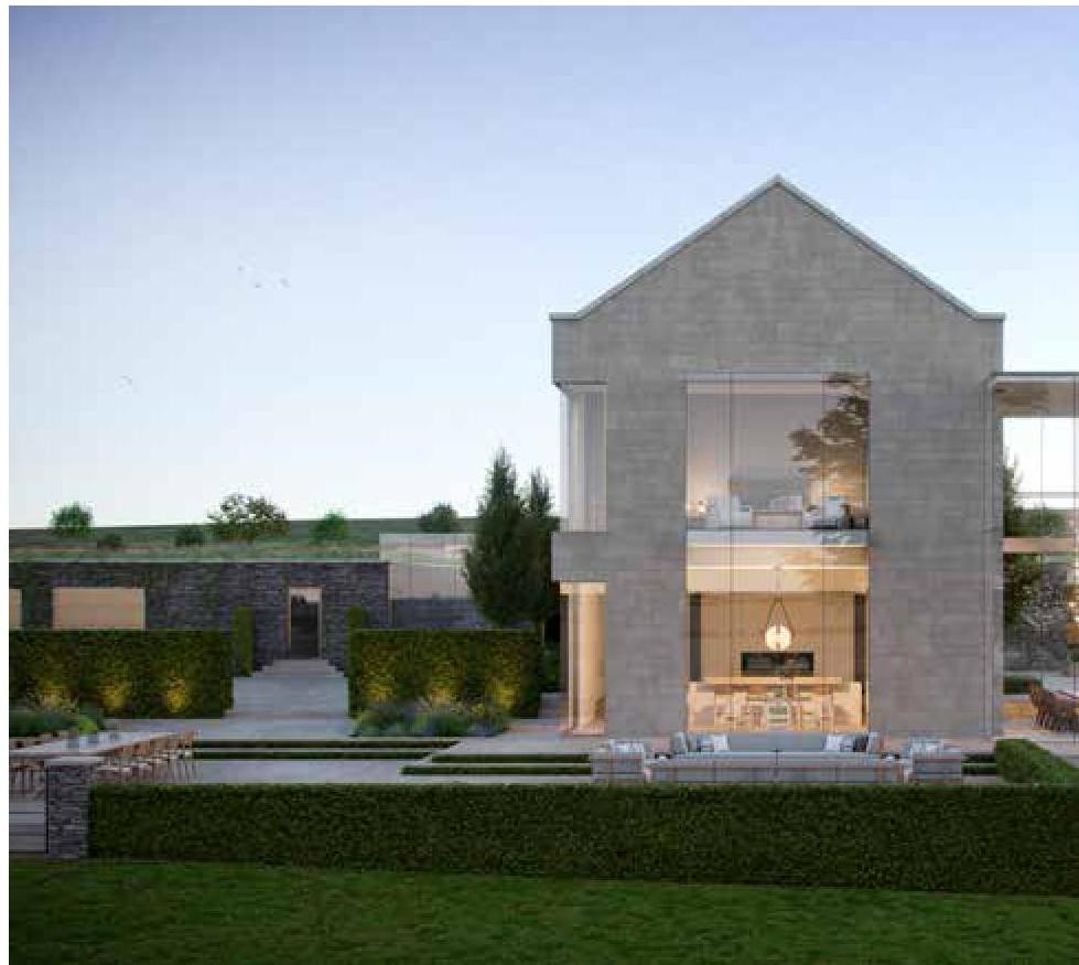
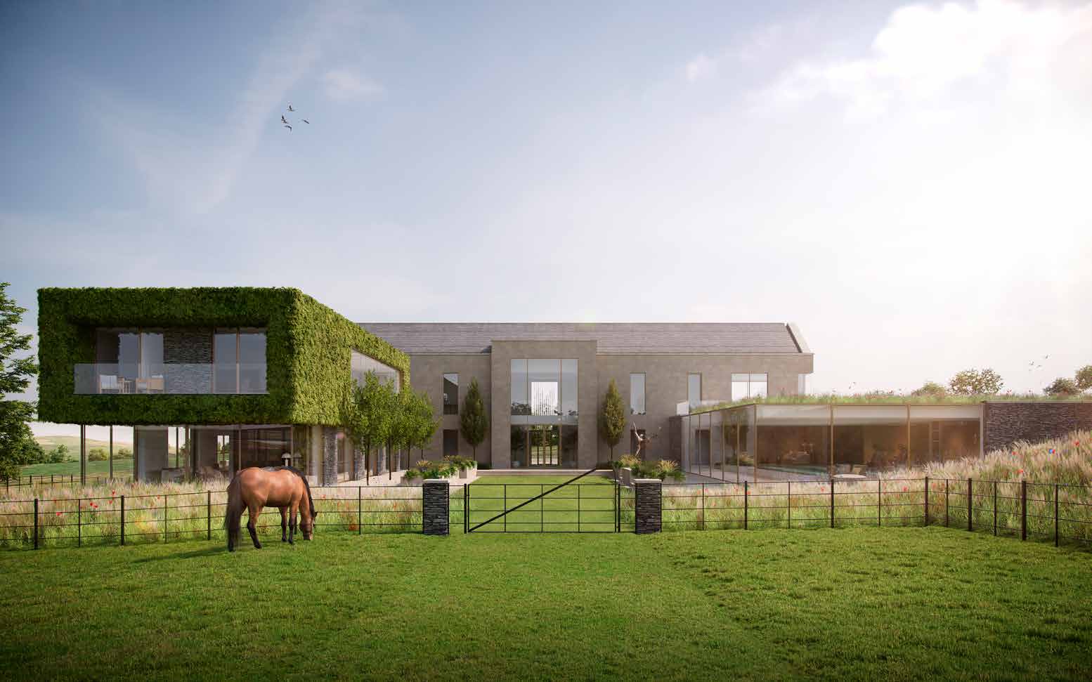
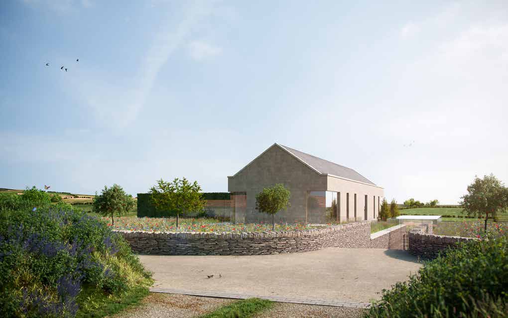
Architectural elevation rendering of a proposed two-story stone replacement dwelling with an attached wing.Architectural elevation rendering of a proposed two-story stone house and an adjacent converted barn structure with landscaping.
5.4.1 The historic planning applications on the site primarily relate to additional buildings/ changes for the extension and maintenance of the farm and buildings. The following applications were all approved:
• PA 84/00193/B, Cubicle house, milk storage tank, conversion of cow house to milking parlour and formation of silage pit (note: the new cubicle building was to have a cement roof and wall cladding)
• PA 95/1715/B, Erection of agricultural building with lean to extension
• PA 06/01362/B, Installation of uPVC windows to replace existing.
5.4.2 Of relevance, are the more recent applications, noting both of which were withdrawn at the behest of the applicant.
• PA 20/00386/B Erection of a detached dwelling with alterations to the associated residential curtilage, 07.03.20
• PA 21/00163/B Erection of a detached dwelling with alterations to the associated residential curtilage,
5.4.3 Advise and commentary received and submitted in regard to both withdrawn applications have been considered in the development of the proposed scheme.
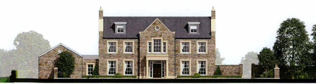
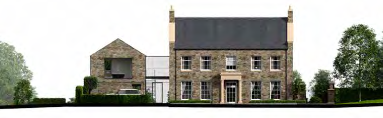
PA 20/00386/B Proposed North Elevation NTS
PA 21/00163/B Proposed North Elevation NTS
6.0 PLANNING STATEMENT
6.1 Relevant Documentation
6.1.1 In consideration of Planning Policy adherence the following has been reviewed:
• Isle of Man Strategic Plan 2016 (the ‘SP’)
• Area Plan for the South 2013 (‘the Area Plan’)
• 1982 Development Plan (‘the Development Plan’)
• Town and Country Planning (Amendment) Act 2019 (the TCPPA 2019’)
• Draft Planning Policy Statement PPS 2/09, The Role of Landscape Character in Development
6.1.2 Reference has also been made to Planning Circular 3/91 Guide to the Design of Residential Development in the Countryside.
6.2 Key Criteria
6.2.1 Ahead of discussing specific policies, it is noteworthy that the site:
• lies within an area which is not designated for a particular purpose on the Area Plan;
• is not set within a Conservation Area - the conservation area of St Marks is nearby
• has no registered trees on site - there are few trees on site which are to be retained
• does not contain any Registered Buildings, nor are any being considered for registration
Ballacroak Farm was recently considered for Registration in 2020 but Registration did not ensue (ref 21/01373/RBINV).
• does not sit within an Area of High Landscape or Coastal Value and Scenic Significance (‘AHLV’) - there is an AHLV to the east of the site
6.3 Planning Consultations
6.3.1 Ahead of formal submission discussions took place with Senior Planing Officer Jason Singleton. These were followed by formal pre-application and subsequent presentation where the scheme was discussed in full.
6.4 Policy Evaluation
6.4.1 The following outlines the considerations for the principle relevant policies of the Strategic Plan.
6.4.2 Strategic Policy 1 stipulates that any "development should make best use of resources". The proposed scheme achieves this by utilising "previously developed land…unused and underutilised land". The site is to be used efficiently, utilising existing access responds to the landscaping and utilising the existing service infrastructure
6.4.3 Strategic Policy 4 refers to AHLV and protection of Conservation Areas. Whilst not within an area of AHLV it is adjacent to one and as such the design shall endeavour to "enhance the landscape quality and nature conservation". The same level of respect for locality and consideration of the design as been applied to the scheme as though it were in a Conservation Area.
6.4.4 In accordance with Strategic Policy 5 the intention is that the development of the site shall make a "positive contribution to the Island", being of exceptional and innovative design; the proposal has been designed to take into account its context, is using innovative materials and technologies to support the high energy efficiency objectives and is of high architectural merit as demonstrated herein.
6.4.5 General Policy 3 sets out that one of the exceptions to the presumption against development in the countryside is "the replacement of existing rural dwellings; (Housing Policy 12, 13 and 14)". This leads to a requirement to assess whether the demolition and replacement of the dwelling -which is the subject of this application - is acceptable.
6.4.6 Housing Policy 12 : "The replacement of an existing dwelling in the countryside will generally be permitted unless: (a) the existing building has lost its residential use by abandonment; (b) the existing dwelling is of architectural or historic interest and is capable of renovation [emphasis added]
6.4.7 HP12a is considered to be met as, in accordance with the defined criteria, the property has not lost its residential status:
• The structural condition of the building whilst neglected, the farmhouse is in a structurally acceptable condition.
• The period of non-residential use or non-use in excess of ten years - whilst the property has not been used for over 10 years, efforts have and are being made to establish the farmstead as are residential property over the last few years as evidenced by the withdrawn applications
• Evidence of intervening use - there has been not been any intervening use since the farm became redundant
• Evidence of intention, or otherwise, to abandon - the recent withdrawn applications support the intention to develop the site rather than abandon
6.4.8 In regard to HP12b, as previously mentioned, Ballacroak Farm was recently considered for Registration however this did not ensue, the assumption being that it was not deemed of significant architectural or historic importance.
6.4.9 It is acknowledged that the status of being Registered is not the only test of whether a building is of architectural or historic interest, although it is one of the three main ones identified in Planning Policy Statement 1/01 - Policy and Guidance Notes for the Conservation of the Historic Environment of the Isle of Man. The other two identified in this document are National Heritage Areas and Conservation Areas. Ballacroak is not within any of these.
6.4.10 There is arguably nominal default historic and/or architectural interest due to the fact that it is a historic Quarterland farm, however as identified in the reports and ultimately the conclusion by the department when assessing potential registration, the architectural and historic interest is limited and arguably heavily diminished by modern alterations.
6.4.11 The historic associated land holding has long gone. The remaining farmhouse is undoubtedly old and on first inspection may have been considered not to have been significantly altered. It has certainly not been extended however, it has been re-rendered in pebbledash and new plastic framed windows have been installed along with a new roof.
6.4.12 The remaining associated farm buildings are large scale, modern portal frame building in poor repair, offering little historic or architectural interest. It is these buildings that dominate the visual amenity of the site, not the historic farm house. Whilst typical of their rural location they detract rather than enhance the landscape.
6.4.13 HP12b stipulates that a replacement dwelling would not be considered if it is of architectural or historic interest AND be capable of renovation.
6.4.14 As mentioned in 4.3.9, it is unlikely the existing house would meet the criteria of being capable of renovation under Housing Policy 12b. The works required to the house go beyond the definition of renovation in building regulations and instead involve replacement and rebuild of a number of structural elements (as detailed in the various reports).
6.4.15 These part replacement/rebuild works go beyond the criteria in Housing Policy 12b. They also would not be considered an economical proposition as they would require significant financial outlay.
6.4.16 The farmhouse is in a poor state of repair as already detailed with damp ingress evident and structural deficiencies. The remaining portal frame buildings would only be worthy of renovation if maintained as agricultural buildings which is not the intent.
6.4.17 As previously mentioned, due to the structural condition of the farmhouse the property is not deemed capable of renovation and any further part replacement/rebuild works would require disproportionate expenditure. The building is traditionally built on shale foundations. Any alterations and/or extensions should require the property to be underpinned to ensure structural stability to support such works.
6.4.18 The part replacement/rebuild works would also leave a resultant building that falls short of desired performance under Building Regulations, the Climate Change Act, or modern space standards. In order to improve the thermal efficiency of the building insulation would be required, either internally or externally, the result being reduced floor area of an already small footprint by modern standards or a dramatic change in the external appearance of the building which in turn may impact on any perceived historic visual amenity.
6.4.19 It could be argued that the part replacement/rebuild works could possibly be partially offset or made more financially attractive by extending the dwelling however, a 50% increase in footprint as permissible under HP15, would result in a property of 416.22 sqm. This would create a substantial family home, but one that is restricted in style, that would be a compromise of environmental performance.
6.4.20 The financial implications of a partial replacement/rebuild and/or extension are largely subjective as the quality of design and finish may be impeded by available financial resources. So whilst a historic farmhouse may be maintained its value may be severely compromised.
6.4.21 It is felt that the cost of the works to partially replace/rebuild this property and its resultant value, whilst going beyond renovation in Housing Policy 12b would also deter anyone from undertaking this work and that as such the retention and works to this property are not a viable proposition which will come to pass if applications for its redevelopment are not considered positively.
6.4.22 Whilst it is often desirable to retain fabric of some interest, this desirability must be weighed against the financial cost of the works, whether they are likely to be undertaken and whether the historic and/or architectural value and interest warrant such a position, in the knowledge that the works may never actually be undertaken if they are considered to be financially unattractive or if finance cannot be made available.
6.4.23 Housing Policy 14 Permits replacement dwellings if: not substantially different to the existing in terms of siting and size, unless changes would result in an overall environmental improvement [emphasis added]
6.4.24 As outlined further herein, the proposed building largely sits over the footprint of the existing dwelling as well as other buildings of the farmstead. Indeed, the positioning of the existing farmhouse as well as the existing and former agricultural building and most importantly the historic axis of the site have directly influenced the proposed positioning of the house.
6.4.25 The size of the proposed dwelling is larger than the existing farmhouse, and is in excess of the permissible 50% under this policy when comparing the existing size of the farmhouse only. However, as discussed further within the Design Statement, given this application seeks approval for the demolition of all of the remaining buildings on the site the scale of these may also be taken into consideration.
6.4.26 The architectural styles being considered for the proposal do not conform with Planning Circular 3/19 as advised by HP14 rather the proposed styles is "of innovative, modern design where this is of high quality and would not result in adverse visual impact’ [emphasis added]
6.4.27 As described in detail further herein, an understated rural aesthetic utilising innovative technologies is proposed that has been considered as part of a holistic landscape scheme ensuring the scheme sits comfortably in its setting with arguably a betterment of the site visual impact.
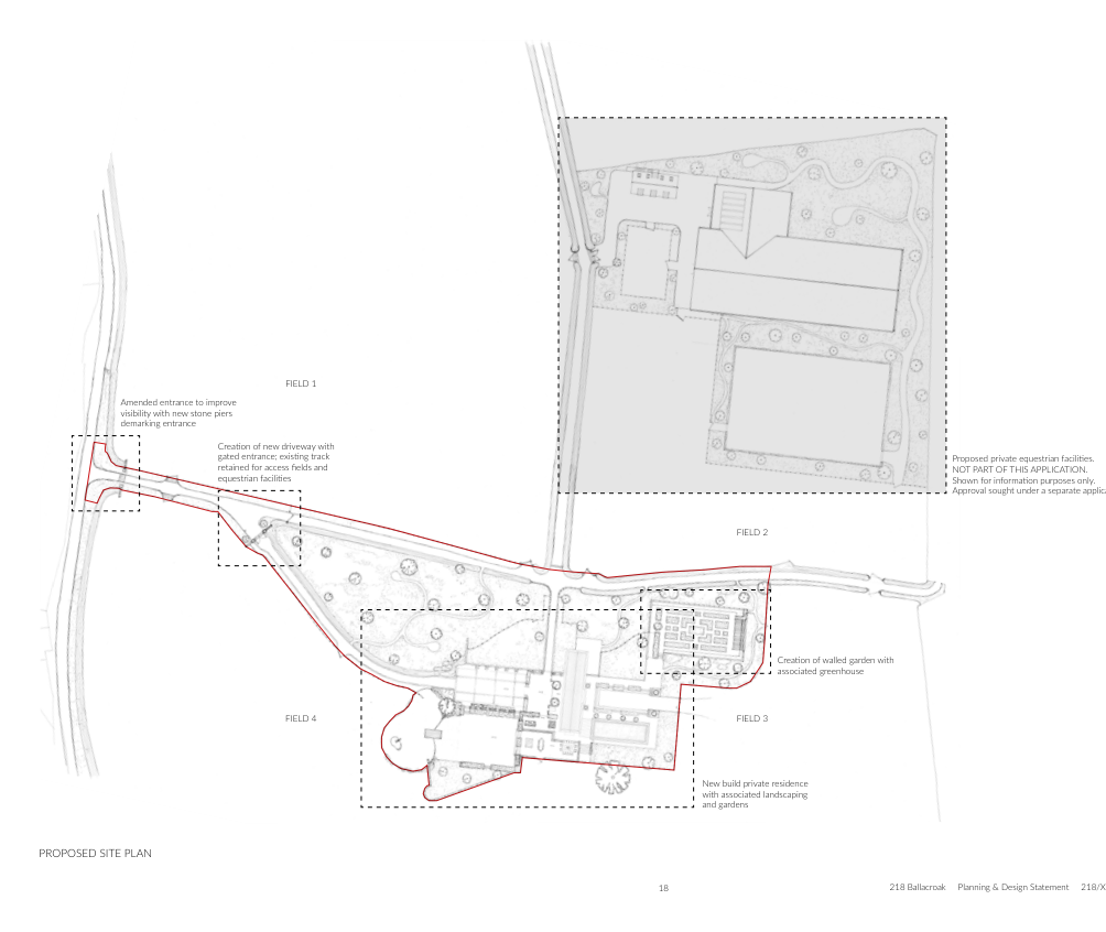
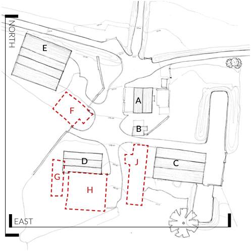
N
FIELD 1 FIELD 2
1869 Os Map Extract
(low resolution image)
Accessoff
Mullinaragher
Road
Historic access
E
A
J C
B
F
D
G
FIELD 4 FIELD 3
H
Towards Valley
Towards Valley
Towards Snaefell Historic N/S Axis Historic E/W Axis Historic access Original Buildings
Sunpath
Views
Prevailing Wind Direction Mature Tree to be retained Existing access gate Area at risk of surface flooding (low - medium) Footprint of demolished buildings
X/X
Existing / Demolished Building Reference
7.0 INITIAL DESIGN CONSIDERATIONS
7.1 Design Brief
7.1.1 The initial appeal of the site for the applicant was it countryside setting and far reaching views. In designing a key design criteria in creating their forever home they wanted to take advantage of, and maximise the enjoyment of both of these aspects.
7.1.2 In doing so the design for both the house and the landscape was to:
• Be site responsive and specific
• Have a restrained contemporary aesthetic whilst being respectful of the location
• Be configured to continually appreciate the setting throughout the day and through the seasons
• Provide a generous home in terms of space and accommodation
• Address the potential risk of surface water flooding in and around the site
• Create an exceptional home for their family with considered landscape design that did not detract from the countryside setting.
• Utilise green energies (viability of options currently being investigated)
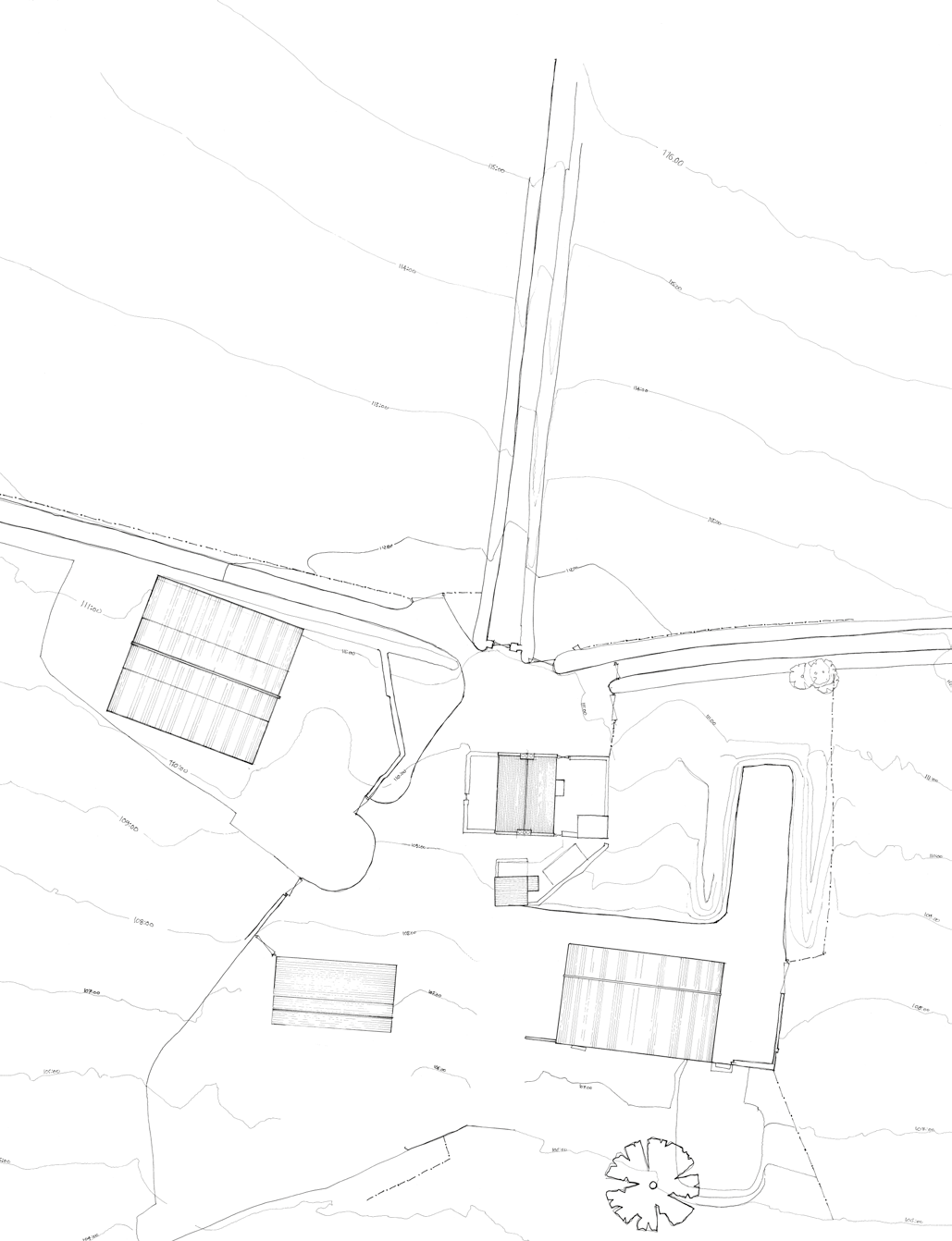
7.2 Site Analysis
7.2.1 The detailed site analysis comprised field and desk based investigations determining any potential constraints and desirable characteristic as well as matters that needed to be addressed as part of the scheme such as the drainage across the site.
7.2.2 The diagram opposite summarises the site specific criteria that has directly influenced the proposal for the site.
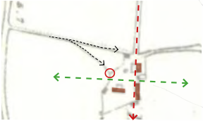
7.2.3 The historic maps illustrate a dominant East-West axis on the site on which the original buildings are orientated along ,and perpendicular to, which extends between Fields 1 and Filed 2.
7.2.4 The existing driveway runs South-North creating a distinct cross road with the lane and a natural central focal point which is where the existing farmhouse is sited.
7.2.5 A forked access off the existing driveway to the farmyard is also evident which terminates to the East of the current entrance. There is an existing access gate which is believed to related to this historic access.
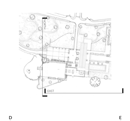
7.2.6 The analysis also established key external viewpoints and therefore key elevations discussed further herein as part of the Visual Impact Assessment.
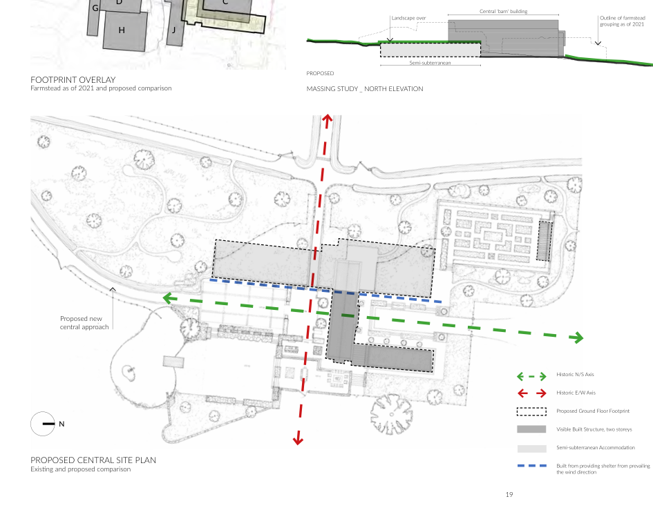
E A B C D
SITE ANALYSIS
Key external elevations
A technical site plan showing topography with contour lines, existing buildings, and road access in a rural setting.A schematic site plan showing proposed building footprints, directional arrows indicating access, and boundary lines.
8.0 Design Statement
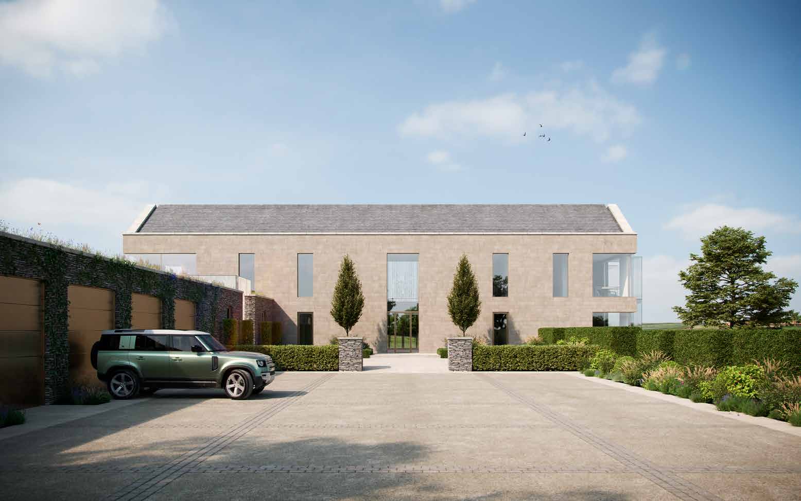
A photorealistic architectural rendering of a proposed modern detached dwelling featuring a stone facade, large windows, and a paved driveway with landscaping.A photorealistic architectural rendering showing a proposed modern detached house with a pitched roof, gravel driveway, and stone boundary walls in a rural setting.
FIELD 1
Amended entrance to improve visibility with new stone piers demarking entrance
Creation of new driveway with gated entrance; existing track retained for access fields and equestrian facilities
Proposed private equestrian facilities. NOT PART OF THIS APPLICATION. Shown for information purposes only. Approval sought under a separate application.
FIELD 2
Creation of walled garden with associated greenhouse FIELD 4 FIELD 3 New build private residence with associated landscaping and gardens PROPOSED SITE PLAN
A technical site plan labeled 'PROPOSED SITE PLAN' showing the layout of a new private residence, driveway, and landscaping across multiple fields.
8.1 Siting and Orientation
8.1.1 This historic axis and approaches, along with the positioning of the existing buildings, have directly influenced the siting and orientation of the proposed scheme.
8.1.2 The proposed reinstatement of the lower access for the creation of a more centrally located driveway follows the perpendicular South-North axis creating a natural position for a proposed courtyard
8.1.3 The resultant cross point creates forms centre for the scheme being the entrance courtyard.
8.1.4 The proposed buildings respect the established historic dominant East-West axis. The main body of the building runs along the North side of this as existing/former buildings A, B and J. The entrance to the central building being on the North - South axis with a visible connection to the fields beyond via the East-West axis.
8.1.5 Furthermore, the proposed buildings are orientated to take full advantage of the view afforded to the site as well as benefit from solar gain throughout the course of the day.
8.1.6 Being positioned in the locality of the existing farmyard and responding to the site axis as the original layout did inevitably means that the proposed building is positioned in the vicinity of the existing buildings siting partially over a number of buildings.
8.2.2 The natural levels of the site have enabled the opportunity for semi-subterranean accommodation to be introduced which assists in providing the accommodation desired by the applicant whilst reducing the associated visual mass, namely the wellness facilities and garaging.
8.2.3 The subterranean element of the scheme and principal living accommodation is sited along the existing contours of the site with the central building set across the fall of the site as it slopes from West to East, verging towards South West to North East.
8.2.4 Those areas intended to be subterranean are to the West of the site with the building 'opening up' towards the East as the existing topography falls away.
8.2.5 The natural fall of the site has influenced the internal levels of the dwelling with changes in level being introduced through the property stepping down towards the East.
8.2.6 The existing levels are also utilised within the landscape design providing natural protection from the prevailing wind direction.
Proposed new central approach Historic N/S Axis Historic E/W Axis Proposed Ground Floor Footprint
N
Visible Built Structure, two storeys
Semi-subterranean Accommodation
Proposed Central Site Plan
Built from providing shelter from prevailing the wind direction
Existing and proposed comparison
Technical architectural drawing sheet showing a proposed central site plan, footprint overlay, and north elevation massing study.A site plan showing the layout of existing and proposed buildings labeled with letters A through J.
EXTERNAL AREA MEASURES
sqm
8.3 Scale
8.3.1 The scale of the proposed property is informed by the accommodation requirements for modern family life as well as the lifestyle expectations and aspirations of the applicant and those of the market for a property of this standing. As such, provision has been made for the inclusion of wellness facilities, including a swimming pool and gymnasium. The swimming pool in particular dictates a larger footprint.
8.3.2 In terms of scale, reference is made to HP14 and potential acceptance of a 50% for a replacement dwelling however, it should be noted that the design has been approached from an architectural and aesthetically stand point rather than a mathematical one.
8.3.3 Furthermore, Noting that Planning Policy requires buildings to be measured externally it is worth noting that the floor area of the proposed is also affected by intended build methodologies to allow for high levels of insulation levels in order to satisfy Building Control requirements and in response to the recent Climate Change Act, the resultant external walls being in excess of 500mm thick.
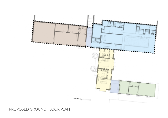
8.3.4 The proposed floor area which is set over two floors is 2,210.71 sqm, inclusive of garaging and plant as they are not insignificant. However, over 50% of this total floor area is intended to be semi-subterranean with only half of the associated elevation being discernible from outside of the site; the elevation of the wellness facilities opens onto the private concealed courtyard.
8.3.5 Therefore the semi-subterranean floor area measure has been excluded from the floor area calculations. This provides a floor area of 1,065.62 sqm.
8.3.6 In relation to the existing floor area of the farmhouse - 253.58 sqm over two floors plus the small adjacent out building - undeniably the scale of the proposed scheme is far in excess of the guideline of a permitted 50% increase in floor area from that of the original property, as outlined in HP14 in reference to a proposed replacement dwelling in the countryside.
8.3.7 However, as this application seeks approval for the replacement of the farmstead in its entirety, with all buildings being replaced with a residential dwelling, it is suggested that there is justification for their floor area to be included in the calculations.
8.3.8 Accordingly, based on the existing building floor area of 1,478.13 sqm, the proposed residential development floor area as established above, would be a 27% decrease being below the 50% increase permissible under HP14.
8.3.9 Furthermore, should the floor area measure of those buildings now demolished also be taken into consideration the total floor area measure would be 2,180.04 sqm. Therefore the proposed floor area would result in 51% less floor area from what was the total external floor area of the farmstead.
8.3.10 It is acknowledged that the semi-subterranean spaces are not insignificant but we are unaware of any policy guidance as to how this would be accounted for. Comments put forward by the planning inspector for PA 08/01338/B (the replacement of Clybane Farm in Braddan), suggested that 50% of the semi-subterranean accommodation be included in any mathematical comparison.
8.3.11 However, in this instance, given that the semi-subterranean accommodation is largely obscured from view being within the concealed courtyard, and that which may be visible from outside of the site (albeit fleetingly as discussed with the Visual Impact Assessment) comprises garaging and plant not living accommodation. Therefore it is felt reasonable that this area be discounted from the floor area calculation.
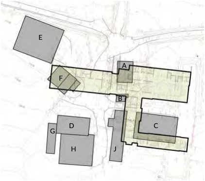
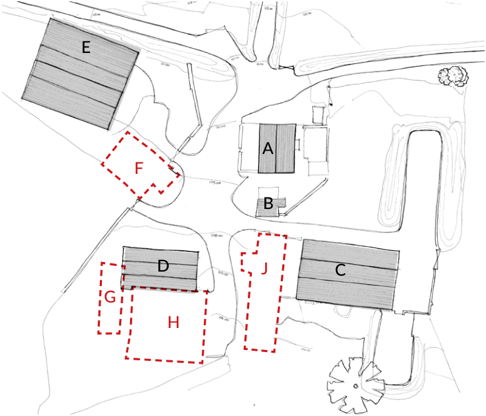
E
Existing Buildings
A Two storey
B Stone outbuilding
C Partial double height
D Partial double height
E Double height
Demolished Buildings
F Double storey
G Single storey
H Partial double height
227.48
(attic space excluded)
26.10 347.80 367.20 509.55
A
B
F
1478.13
Total Existing
D
J
C
G
H
237.60
80.00 317.73 388.72 FARMSTEAD BUILDINGS J Single storey, part two storey 1024.05 2502.18 Total Demolished Total Recent Farmstead
External Area Measures
sqm
Semi-subterranean accommodation Garaging and plant Glazed Link Wellness / Entertainment facilities
431.60
36.00 677.49
Total Semi-subterranean
1145.09
Living accommodation Glazed Link
239.64
39.50 182.04 461.18 PROPOSED GROUND FLOOR PLAN Living accommodation Total Ground level Total Ground Floor
1606.27
Living accommodation Glazed Link Living accommodation
355.32
Void, double height space Including external balcony (15.40 sqm) Total First Floor
37.92 211.20 604.44
2210.71
Total External Floor Area
1065.62 Excluding semi-subterranean floor area
PROPOSED FIRST FLOOR PLAN
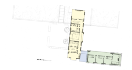
The image shows a technical architectural drawing labeled 'PROPOSED GROUND FLOOR PLAN', displaying the layout of rooms and spaces for a new development with color-coded sections.This image displays an architectural ground floor plan for a proposed replacement dwelling, showing room layouts and the building footprint.
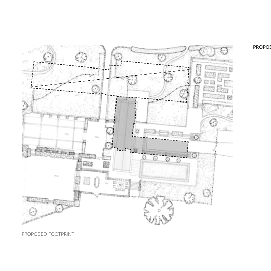
Existing Footprint
A site plan showing existing buildings labeled A, C, D, and E alongside proposed areas marked with dashed red lines F, G, H, and J, set against a topographical background.The image shows an architectural site plan illustrating the proposed footprint of a new dwelling (shaded grey) in relation to existing structures and landscaping.
8.3.12 Given the nature of some of the existing and former buildings - which includes a variety of double storey portal frame buildings which do not provide floor area at first floor level, however do contribute greatly to the scale of the perceived existing farmstead - a more reasonable comparison may be the footprint of the existing and proposed and that of their massing.
8.3.13 This application seeks to create a substantial property in terms of accommodation but the visible ground floor footprint of the proposed property totals 461.18 sqm.
8.3.14 This is 60% less than the existing total footprint of the existing buildings being 1,182.29sqm.
8.3.15 For completeness, including the demolished buildings, the footprint area of the existing would provide an existing floor area of 2,067.11 sqm meaning the proposed would be a 77% reduction in visible floor area.
8.3.16 As mentioned, given the variable scale of the existing and former buildings on the site, a more relevant comparison may be the visible massing of the buildings on the site.
8.3.17 The perceived visual impact of the proposal has been carefully developed in consideration of the existing massing.
Existing Buildings
sqm 115.24
E
A
B
C
D
E
Demolished Buildings
F
G
H J
26.10 347.80 183.60 509.55
A
B
F
1182.29
Total Existing
177.12
D G
J
C
80.00 317.73 309.97 884.82
H
Total Demolished Total Recent Farmstead
2067.11
EXISTING FARMSTEAD FOOTPRINT PROPOSED FOOTPRINT sqm 461.18 TOTAL PROPOSED FOOTPRINT
8.3.18 The diagrammatic comparison drawings of the North and East elevations illustrate that whilst the visible mass of the proposed building is marginally moved to the East and North of the site from the existing, the volumes are less than those of the former farmstead, including the demolished buildings, particularly on the East elevation.
8.3.19 The proposed North elevation provides more accommodation at first floor level, taking advantage of the far reaching sea views, which results in a marginal increase of visual mass from the existing at that level but this level is not dissimilar to the ridge line of the existing farmhouse.
8.3.20 The proposed East elevation whilst long in totality is set on different planes. In fact the sprawling massing of the existing farmstead will be replaced by a more compact grouping whose visual mass being 'broken' by the fully glazed links recreating the appearance of a group of buildings.
8.3.21 The effect of the change in massing is discussed further within the Visual Impact Assessment.
E
A
B
F
D G
J
C
H
EAST EAST
8.4 Form
E A B C D E D A C
Overlay
EXISTING EXISTING
F J G H G F H J
Existing
PREVIOUS (2021) PREVIOUS (2021)
Central 'barn' building Garage elevation (subterranean accommodation)
Glass
link Living wall elevation Glass link Central 'barn' building Subterranean garage accommodation Glass projection Outline of farmstead grouping as of 2021 Outline of farmstead grouping as of 2021 Line of living wall beyond Subterranean accommodation
Set back
Proposed
Level change for entrance forecourt
PROPOSED PROPOSED
MASSING STUDY _ NORTH ELEVATION MASSING STUDY _ EAST ELEVATION
A black and white architectural site plan showing building footprints, tree locations, and orientation markers for North and East.A site plan showing existing buildings labeled A-E and proposed areas outlined in red dashed lines, with North and East orientation markers.
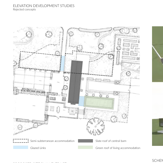
Elevation Development Studies
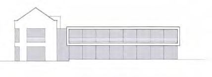
Architectural elevation drawing showing a proposed replacement dwelling with a two-story section and a long flat-roofed wing.Architectural elevation drawing showing a proposed replacement dwelling with a traditional gable section and a modern single-story extension.The image displays an architectural drawing titled 'Elevation Development Studies' showing rejected concepts for a building project, including a site plan with a legend for materials like slate and green roofs.
Rejected concepts Semi-subterranean accommodation Slate roof of central barn Glazed Links Green roof of living accommodation SCHEME SKETCH MODELS PROPOSED SITE PLAN EXTRACT Shown for reference only to illustrate semi-subterranean concept and broken form
8.4.1 Guide to the Design of Residential Development in the Countryside provides guidance for traditional buildings. From the outset a contemporary aesthetic has been preferred with the emphasis on exceptional design in accordance with HP 14. That said, consideration has been given to its guidance due to the proposed location.
8.4.2 The proposed appearance of the property is not of traditional Manx vernacular rather a contemporary rural aesthetic is proposed in response to its rural setting and the desire to create a building of its time rather than a pastiche of historic styles.
8.4.3 A similarity with the local vernacular can be found in the simplicity of the building forms which are elevated beyond a traditional farming vernacular by their refinement of proportion, detailing and choice of materials.
8.4.4 In response to its rural setting and the sites farming history the scheme has been designed to comprise different elements reflecting the variation of form found within a traditional farmstead grouping.
8.4.5 The resultant scheme comprises of three main elements:
• Semi-subterranean buildings that open out to the east of the site. These shall have planted living roofs so as to read as part of the landscape albeit for one visible elevation. These shall house the garaging to the South being connected to the principle building by a glass link with the spa facilities being housed in the north whose east elevation opens onto an internal courtyard. The concept for the garaging elevation is that it should read as a continuation of the Manx stone garden wall.
• A central double storey stone building being a contemporary take on an agricultural building being simple in design but elevated by its detailing and materiality. The principal elevation of this building is the only discernible elevation when approaching the dwelling
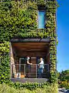
• The contemporary double storey living accommodation block is orientated to take advantage of the views having large expanses of glazing at ground floor with the upper floor being softened by its living wall facade with the intention that it shall blend into the landscape when viewed from outside of the boundary. The planting of the living wall shall continue over the parapet edge providing a soft edge to the building.
8.4.6 These elements are connected by the introduction of minimal glazed links reinforcing the concept of a grouping of building and assisting in 'breaking up' the visual mass of the overall scheme.
Manx Stone recycled from site Dressed Manx Stone coping on parapets Light tooled dry jointed stone wall cladding with Copper roof, over glass link, allowed to age naturally Coursed split & cut Manx Stone piers First floor living wall with overlap onto parapet to create soft roof edge
Estate fencing
dressed stone coping
EAST ELEVATION This illustrates how the garage elevation shall b obscured by considered landscaping scheme and how the walled garden nestles into the contours of the site
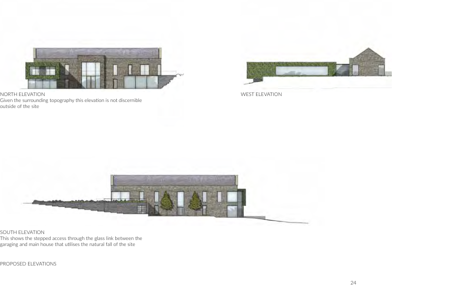
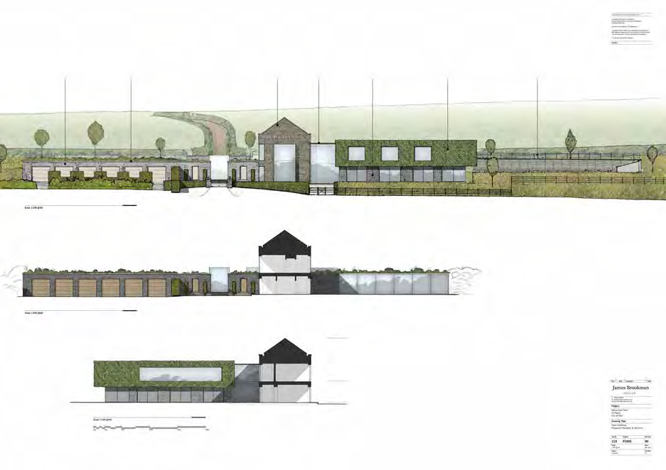
East Elevation (with proposed landscaping) Long Section (Through Main Barn & Rear Courtyard showing West Elevation of Contemporary Wing) NORTH ELEVATION Given the surrounding topography this elevation is not discernible outside of the site
WEST ELEVATION
North Elevation West Elevation
SOUTH ELEVATION This shows the stepped access through the glass link between the garaging and main house that utilises the natural fall of the site
PROPOSED ELEVATIONS
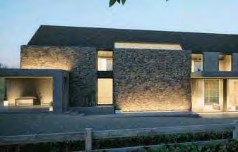
Architectural elevation drawings showing the proposed North, West, and South facades of a new dwelling with stone cladding and glass features.Architectural elevation drawings illustrating the proposed North, West, and South facades of a modern stone dwelling with glass features.Architectural elevation drawings showing the proposed North, West, and South views of a modern stone dwelling with a glass link and garage.Architectural elevation drawings showing the proposed North, West, and South views of a modern stone dwelling with a glass link and garage.Architectural elevation drawings showing the proposed North, West, and South views of a modern stone dwelling with a glass link and garage.Architectural elevations and perspective rendering showing the proposed replacement dwelling and surrounding landscape.
ARTIST IMPRESSION OF GARAGE AND ENTRANCE FORECOURT Illustrating how the restrained symmetrical aesthetic of the central building, with minimal window frames
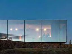
PRECEDENT IMAGERY Planted living roof / minimal glazed elevation / contemporary barn aesthetic / living wall
8.5 Materiality
8.5.1 The varying, yet complementary, selection of architectural styles and materiality has been influenced by the existing tapestry of materials and forms on the site.
8.5.2 A "whitefinishisverycharacteristicoftheruralpastsoftheIslandandshouldremain astandardrequirementfornewbuildinginthecountryside.Modernconstructionand materials may be used to achieve a similar external appearance" (GRDC p.5).
8.5.3 Not being of traditional form, a white rendered finish as traditionally seen through out the island is not considered appropriate for the scheme. A more subdued finish is desired and more befitting of its open location to blend more seamlessly with its surroundings. In addition a long lasting, high quality finish is desired.
8.5.4 A natural stone is proposed for the central barn, the final specification of which is still to be determined. The intention that this shall have a light tone but shall be lighter in colour than traditional Manx stone. The earthy, natural tone of such a stone shall enable the building to sit more comfortably in its landscape. This shall be detailed and coursed to reflect the contemporary aesthetic of the building.
8.5.5 Manx stone is proposed to be used for the ground floor stone piers below the living wall elements. The change in stone further emphasises the concept of a broken elevation with differing elements as per a traditional farmstead grouping.
8.5.6 Roofing comprises a combination of traditional slated pitched roof with planted living roof. Rainwater goods shall be concealed as much as viably possible retaining the clean contemporary aesthetic.
8.5.7 Living wall (green wall/vertical garden) choice drives an environmentally aware approach along with the desire to reduce any potential impact of the project.; this architectural component will allow the building to blend effortlessly with the rural setting. Living walls as are often used in urban contexts where the planting is varied providing dramatic visual interest. We are intending to utilise a living wall system as a rain-screen cladding solution, which shall be planted with only a few evergreen species as to create a more natural and organic appearance.
8.5.8 The planting shall be evergreen to ensure that the substructure is always concealed, but this may be scattered with a small number of perennial plants to add seasonal interest along with the possibility of incorporating wildlife habitats.
8.5.9 The green roofs over the semi-subterranean accommodation are intended to be fully planted with local species of grass and wild flowers to read as an extension of the rural landscape. The build up of these roofs shall also allow for trees to be planted.
8.5.10 Glazing shall be as minimal possible with slimline bronze frames proposed for all windows. The glazed links and the elevation of the wellness facilities being designed to read as fully glazed façades as much as viable.
8.5.11 The attention to detail and design consideration demonstrated in the main building continues throughout the landscape design which is discussed further herein.
8.5.12 The local stone from the demolished buildings is intended to be utilised for the retaining walls in and around the property with those further away from the property being more rustic in their laying becoming more consistent and refined as the wall approach the
218 Ballacroak Planning & Design Statement 218/X/PN/220328 Rev A
A photorealistic architectural rendering of a modern, single-story detached house featuring a stone base and extensive glass glazing, set against a twilight sky.An architectural perspective rendering or sketch of a proposed stone dwelling with a pitched roof and surrounding landscaping.A photorealistic rendering or photograph of a modern single-story stone house with large windows and a covered patio area at dusk.A modern building facade almost entirely covered in dense vertical greenery with a wooden balcony where two people are standing.
ARTIST IMPRESSION OF EASTERN TERRACE Illustrating how the building mass is reduced through differing forms, height, materiality and glazed links
ARTIST IMPRESSION OF WESTERN APPROACH Illustrating how the natural topography of the site has been utilised and the planting of the living roofs
A photorealistic architectural rendering of a proposed modern detached house with stone cladding and landscaping in a rural setting.
building.
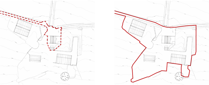
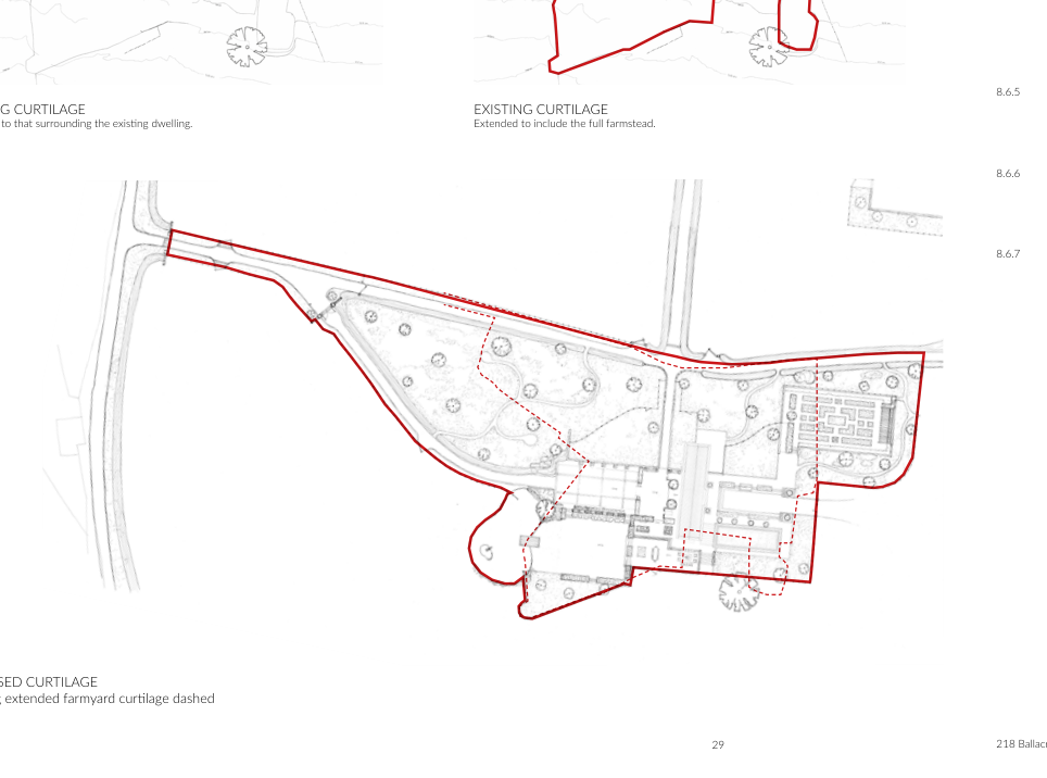
8.6 Curtilage
8.6.1 The residential curtilage of the property is inevitably proposed to change to reflect the proposed residential use and scale of the proposed dwelling.
8.6.2 Within the IOM Town & Country Planning Permitted Development Order 2012 and the Isle of Man Strategic Plan, “curtilage” means the area of land attached to and around a building, used with the building and within which the building is set (for example the garden and driveway of the house, the storage yard of a factory), but does not include land used with a building but severed from it (for example a highway or service lane).
8.6.3 As there is no severance of the farmyard by a highway or service land, the assessment as to what should be treated as the existing curtilage is a matter of fact and degree.
8.6.4 The existing residential curtilage (that area where Permitted Development Rights would be applicable and which could legitimately be used for solely residential purposes) could be deemed as being limited to the immediate area around the farmhouse however, there is evidence of residential use across the wider site such as domestic cars being parked around the site and within outbuildings and historic use of the grassed area to the north of the farmhouse being utilised as garden space with associated polytunnel.
8.6.5 Accordingly, the farmhouse has a clear functional relationship with the buildings within the wider farmyard and therefore it would be expected that the outbuildings be included in the curtilage. This marries with the visual curtilage of the site, established by the clear boundary between the building group and surround field.
8.6.6 As illustrated by the Landscape Design herein, the visual curtilage of the farm and that of the proposed house is arguable established by the area of hardscaping which is notably less in the proposed scheme with large areas of existing farmyard to the West becoming planted meadow grass gardens.
8.6.7 Whilst the residential curtilage is proposed to physically increase, visually its boundary is intended to blend with the surrounding rural landscape with open 'estate' fencing being proposed as described further herein within the Landscape Design so not to deter from
EXISTING CURTILAGE
Existing Curtilage
Restricted to that surrounding the existing dwelling. Extended to include the full farmstead. PROPOSED CURTILAGE Showing extended farmyard curtilage dashed
Two side-by-side site plans illustrating proposed and existing site boundaries with building footprints and topographical contours.This image displays a site plan illustrating the existing and proposed curtilage boundaries, along with building footprints and landscaping features.
the concept of the property being part of its rural surroundings.
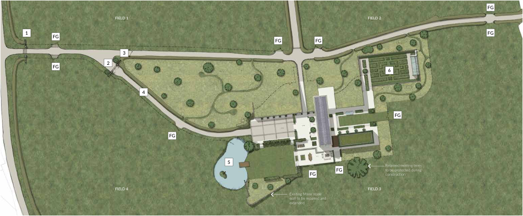
8.7 Landscape Design
8.7.1 The landscape design for the property forms an important part of the scheme and has been developed as part of the overall holistic plan which includes equestrian facilities
FG
FIELD 1 FIELD 2
FG
1
FG
FG
FG
3
2
FG
6
4
FG
FG
5
Retained existing trees to be protected during construction
FG
FG
FIELD 4 FIELD 3 Existing Manx stone wall to be repaired and extended
Meadow grasses with small tree and mown pathways
FG
Field Gate Lawn Bonded pea gravel forecourt with stone sett details
1
3
5
Retained access with new gate Water attenuation pond & reed bed New stone piered entrance with cattle grid
Pasture
New stone piered gated entrance with cattle grid fencing to East
New bonded pea gravel drive way
2
4
6
Walled Garden
PROPOSED LANDSCAPE DESIGN
A site plan showing the layout of a proposed replacement dwelling with surrounding fields, a pond, and landscaping features.
(approval for which is sought under a separate application).
8.7.2 The primary objective for the landscaping within the proposed residential boundary has been to enhance the natural setting of the property whilst being respectful of its surroundings. Whilst the proposal is for a substantial family home, the gardens are to be relatively informal. This is in response to the proposed architecture and being respectful of its rural setting. The small areas of 'formal' lawn and more structured landscaping are intended to be balanced by the notable increase in more organic planting such as the meadow grass gardens.
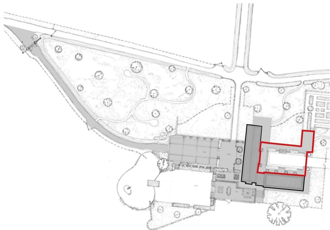
8.7.3 Areas of proposed hardscape, namely the new driveway, garage and entrance forecourt, entertainment areas and pathways around the house, have been considered so as to be retained to a minimum. The garage forecourt shall be light coloured bonded pea gravel with stone sett detailing whilst the other areas shall be flagged.
8.7.4 A large portion of this hardscaping is concealed from the identified key external viewpoints as it sits within the internal courtyard (outlined in red).
8.7.5 The natural levels of the site have been used to create stepped terraces around the property which sit lower than the ground floor of the house. The resultant terraces are proposed to be bordered by a small amount of box hedging which shall serve to conceal the hardscape reducing potential visual impact as discussed further herein.
8.7.6 The boundary between the residential gardens and the surrounding fields is intended to be minimal with the intention to visually blur the demarkation between the two. Accordingly,
EXISTING HARDSCAPE Illustrating extent of exiting farmyard and footprint of former buildings
This is a site plan showing the layout of a property with building footprints and landscaping features. The plan highlights a specific building footprint in red outline.
PROPOSED HARDSCAPE Illustrating the proposed forecourts, terracing and pathways. Extended to show proposed driveway.
A photorealistic 3D architectural rendering of a proposed modern two-story detached house with large glass windows and a landscaped garden.
PARTIAL SOUTH ELEVATION Illustrating lower terracing behind box hedging.
Existing New Manx banking (290m) Existing Manx banking to be repaired (200m) - 'gapped' banking infilled Lifted Manx banking 190m - raised to standard 1.8m
PROPOSED ENTRANCE MANX BANKING PROPOSED GREENHOUSE lightweight 'estate' fencing is proposed retaining the existing open nature of the site.
8.7.7 Existing Manx sod hedges in and around the site shall be retained and 'gapped up' where necessary being planted with local specifies in accordance with Manx Wildlife Trust recommendation e.g. Hawthorn, Blackthorn and some marginal Western Gorse. This mix shall also be applied to the proposed new sod hedges. Reference is also made to the Manx Headgerow Government Guidance, Best Practice Guide.
8.7.8 As identified in the existing site analysis the site is prone to surface water flooding. This is due to the natural topography of the site and inadequate systems in place across the existing hardscaping. Drainage management shall be intrinsic to the success of the proposed landscaping scheme. Accordingly a field attenuation pond proposed to assist with the slowing the flow of upland water as well as part of the management of surface water from the hardscaping. In addition, this shall also house the reed bed required by the intended bio-disc sewerage system.
8.7.9 Subject to scheme approval, the proposed landscape drainage system and the specifics of the planting scheme shall be developed by specialist contractors and local bodies such as the Manx Wildlife Trust. The final planting schemes shall reference Planning Circular 1/93
Landscape Guidance Notes which provides a list of native shrubs that shall be adhered to along with guidance from the Manx Wildlife Trust.
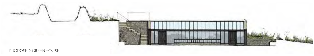
8.7.10 A walled garden is proposed to the North-West corner of the garden providing raised vegetable bed and associated traditional lean-to greenhouse structure. This garden shall be nestled into the exiting topography with a Manx stone clad retaining structure being planted with espalier trees.
8.7.11 The landscape design has been developed so as to retain rural landscape as viewed from Mullinaragher Road.
8.7.12 The open nature of the site is proposed to be retained however some new tree planting
Architectural elevation drawing of a proposed greenhouse structure integrated into a sloping site with stone and glass features.A site plan showing a large black footprint of existing structures next to a detailed proposed building layout with landscaping and access roads.
ARTIST IMPRESSION OF REAR COURTYARD Illustrating how the surrounding pasture is intended to blend into the meadow grass gardens
will be required to blend the building into the landscape.
8.8 Drainage
8.8.1 The sites topography along with the impregnable surface of the existing farmyard and associated landscape contributes to the risk of surface water flooding attributed to the site.
8.8.2 The proposal shall look to utilise singular or multiple SUDs features to aid in the harvesting infiltration, storing and treatment of surface water. This may include swales permeable paving, filter strips/drains rainwater harvesting and ponds.
8.8.3 The proposed living roofs serve to reduces the potential rainwater attenuation on the site forming a key part of the drainage management system. This shall be destined with specialist advisors subject to planning gain
8.9 Ecology
8.9.1 As mentioned, the landscape design forms an important part of the schemes success and this includes the desire to improve the biodiversity of the site.
8.9.2 As part of the previous application a bat survey and a ornithological inspection has already been undertaken and included in the Appendices for reference. There are no bats present on the site and of those birds that are afforded special protection under the Isle of Man Wildlife Act only house sparrows were recorded.
8.9.3 The proposal acknowledges the importance of ecology and biodiversity and will ensure the retention of as much of the existing ecology afforded to the site as viable. Also look to enhance the ecological value of the site and increase biodiversity by including large amounts of additional hedgerows, improvement of the existing and some tree planting throughout - the natural environment shall be in a better state than before construction.
8.9.4 New and re-established hedgerows along with newly created meadow gardens and natural water environments shall be developed, detailed and specified with specialists so as to protect and enhance the existing benefits on the site as well as improve.
8.9.5 It is anticipated that the design development and finalisation of this aspect be conditioned to any planning approval.
8.10 Sustainability
8.10.1 The applicant is keen to incorporate energy efficient measures throughout the scheme. With the requirements of recent Climate Change Policies in mind the applicant is also invested to implement sustainable technologies and energy systems into the property.
8.10.2 As mentioned, allowance have been made for increase levels of insulation as well as the provision of increased plant space that technologies such as ground source heat pumps require.
8.10.3 In the first instance, stone and slate from the site will be reused where ever possible, The Manx stone still on site from the former buildings, and that gained from the demolition of the existing shall be used throughout the site in the creation and maintenance of Manx stone walls.
8.10.4 The proposed replacement dwelling has a heavy focus on sustainability and energy efficiency. The approach is one of minimising energy usage and be as self-sufficient as possible.
8.10.5 In terms of SAP calculations the building shall be targeting an energy efficient rating of A+ through the use of high energy efficiency technologies, design and detailing.
8.10.6 It is the intention that the proposed property be powered by renewable energies and allowance has been made for the inclusion of ground and/or air source heat pumps, the detailed proposals for which shall be developed subject to the success of this application.
8.10.7 Passive environmental control and energy usage have also been implemented, not limited to:
• orientation to maximise solar gain with large windows serving to minimise the use of artificial light.
• LED and low energy lighting used throughout
• Motion sensors and timers utilised internally and externally
• High levels of thermal insulation to building fabric and double glazing and emissivity glass will reduce heat loss
8.10.8 EVC ports shall be included within the garaging.
8.10.9 It is anticipated that the design development and finalisation of this aspect be conditioned to any planning approval.
8.11 Access
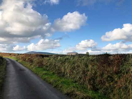
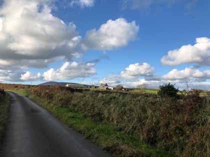
8.11.1 Vehicular access off Mullinaragher Road is to remain albeit visibility splays shall be improved and its appearance elevated to reflect its residential status.
8.11.2 The approach to the main house is to be altered by the reintroduction of the historical forked road to create a central approach to the property. The entrance forecourt shall provide both stepped and ramped access.
8.11.3 The existing driveway is to be retained to service the grounds and the proposed equestrian facilities.
VIEW 1 _ 2021
VIEW 2 _ 2021
VIEW 5 _ 2021
VIEW 1 _ PROPOSED Including proposed increase of Manx bank to reinstate that which has been lost by poor management VIEW 2 _ PROPOSED Including proposed increase of Manx bank to reinstate that which has been lost by poor management VIEW 5 _ PROPOSED
9.0 VISUAL ANALYSIS
9.1 Existing Condition
9.1.1 A definition of 'visual impact' is provided in the consultation paper for DRAFT PPS on Replacement or Extension of Dwelling in the Countryside: "visualimpact"meansnotonly the appearance of the building and site works as viewed from the highway and any other vantage points but also the impacton the appearance and character of the landscape.
9.1.2 Further more, in the same draft PPS it state that the underlying objective of "HP14is toensurethatthechangeinvisualimpactresultingfromtheerectionofareplacement dwellingis,inallcases,noworsethatneutral,andthat,incaseswheretheincreaseinfloor areaisgreaterthan50%,thechangeinvisualimpactisbeneficial".
9.1.3 The existing group of buildings are "prominently placed in the landscape" (GRDC, p3). The farmhouse is clearly visible and the large modern portal frame structures dominate.
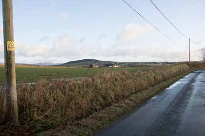
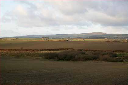
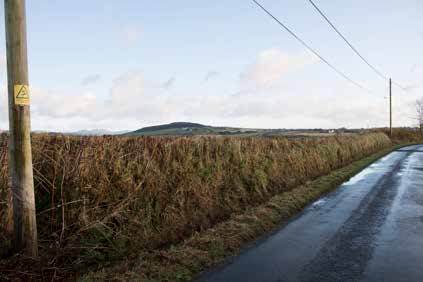
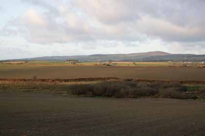
9.1.4 Due to the existing topography, namely the natural West-East fall across the site, the existing buildings are screened meaning that only fleeting view from Mullinaragher road and Ballacorris Road are visible.
9.1.5 The closer vantage points to the site are predominantly obscured by traditional Manx Hedgebank although, as the report by Manx Wildlife Trust alludes to (ref Appendices), these have been not been well maintained and in some small sections, particularly on the Southern boundary of Field 3, (ref View 1) they have collapsed below their expected typical height leaving fleeting views into the site.
9.2 Proposed Impact
9.2.1 Whilst the proposed dwelling comprises a number of buildings, which is reminiscent of a farmstead grouping, due to their arrangement around an effectively internal courtyard coupled with the partial subterranean nature, only a limited number of elevations discernible from outside of the site.
9.2.2 The existing Manx banks across all four fields are intended to be reinstated as part of the landscape design with collapsed areas being 'gapped up' to the same height as those that surround them (and as per PC 1/92) with native hedgerow planting and shrubs being reintroduced. This shall immediately reduce the available fleeting views into the site.
9.2.3 Given the open landscape nature of the site, and the desire to respect and retain this character, as described in the Design Statement the design was developed with consideration of the key views from outside of the site.
9.2.4 Furthermore, the choice of materials further serve to blend the property comfortably in its landscape offering a subdued colour palette.
9.2.5 The resultant effect is similar to the existing, if not arguably a betterment in terms of quality of design and materiality; the positive character of the existing is respected and retained.
218 Ballacroak Planning & Design Statement 218/X/PN/220328 Rev A
10.0 Summary
A photorealistic architectural rendering of a proposed modern single-story replacement dwelling in a rural setting with stone walls and landscaping.
10.2.1 As outlined, and supported by independent commentary, the likelihood of the site returning to a working farm, or indeed being re-purposed for an alternative, is highly unlikely; a working farm of this scale is economically unviable and the condition of the buildings would require substantial, and disproportionate investment to make them habitable and/ or usable for any purpose.
10.2.2 In order to warrant the level of investment required to make the existing farmhouse spatially efficient to modern standards, would require a substantial extension to the floor area of the house to make it financially viable which in turn would destroy any potential architectural or historic interest in the building.
10.2.3 The financial outlay for works required on the existing buildings, drainage management and associated landscaping would also be substantial. It can only be surmised that the scale of funds required to redevelop the site would be prohibitive to many. Without significant investment, the appearance and condition of the site shall deteriorate further.
10.2.4 The historical interest in the site is noted however as referenced in the Strategic Plan "a fine balance… needs to be struck between conservation and enhancement on the one hand, and promoting development and growth on the other” (SP, 7.25.3).
10.2.5 Whilst the applicant wishes to make a significant financial investment in the redevelopment of the site, their objective is to create an uncompromising new build property which satisfies their desire for exceptional and innovative design in the creation if a private residence that is specific and responsive to its site and location rather than a pastiche of local vernacular.
10.2.6 It is deemed reasonable that the property be redeveloped as a private home, as per the previous redundant farmsteads that surround it.
10.2.7 This document has demonstrated how the proposal has been designed and developed to be respectful of the sites history and locality creating a site specific and sensitive response to the client brief.
10.2.8 It is felt that the resultant scheme is exceptional; its high level design and detailing shall result in a property that contributes positively to its rural setting being sensitive and responsive to the defining characteristics of the area.
Copyright in submitted documents remains with their authors. Request removal
Source & Provenance
Official reference
22/00399/B
Source authority
Isle of Man Government Planning & Building Control