Planning Statement In Support Of The Erection Of A Pair Of Dwellings To Replace The Existing, East View, Sulby Bridge, Sulby, Lezayre Im7 2Eu (Resubmission Following Refusal Of 24/00106/B And 25/90189/B)
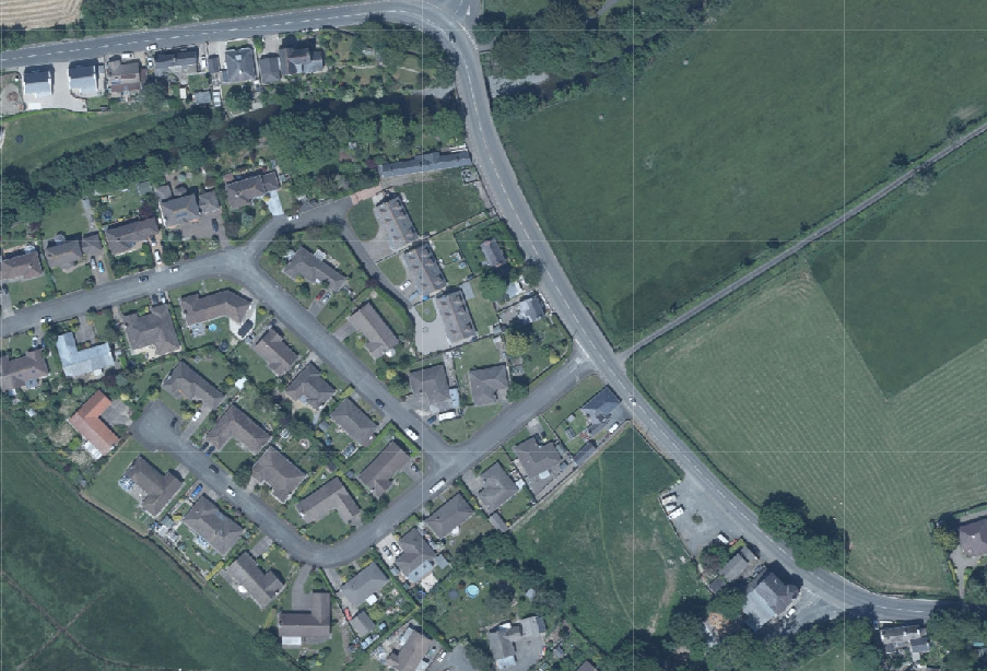
Aerial site location map showing a residential area with houses, roads, and adjacent agricultural fields.
1.0 Introduction
1.1 The site is the curtilage of an existing dwelling, East View, which sits on the western side of the A3 TT course between Sulby Bridge and the Ginger Hall public house, restaurant and hotel. The house is presently unoccupied and is currently largely hidden behind the existing perimeter hedging around the site.
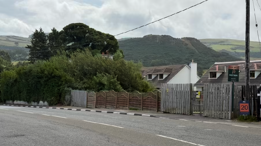
A street-level photograph showing existing residential properties behind a wooden fence, with green hills in the background.
1.2 Planning approval has previously been sought for the replacement of the existing dwelling with a single property which was refused. Subsequent to this, planning approval was sought on two occasions and refused both times for the replacement of the existing dwelling with a pair of two storey dwellings. These are referred to in more detail in the Planning History and assessment section later in this report. This current application seeks to address the reasons for refusal given previously.
1.3 Pre-application advice was sought following the most recent refusal in respect of both the flood risk issue and the design and appearance of the proposed building. The advice provided on both counts has been taken into account in this current application.
1.4 Whilst it is currently not easily seen, East View, the existing dwelling on the site, is a traditional Manx cottage which sits facing the road. To the immediate south is another traditional cottage - Mill View. To the north is an open area which forms the rear garden of 6, Carrick Park. There is a timber fence at the rear of this, bounding the footway alongside the main road: another fence at a higher height sits alongside this in front of the substation.
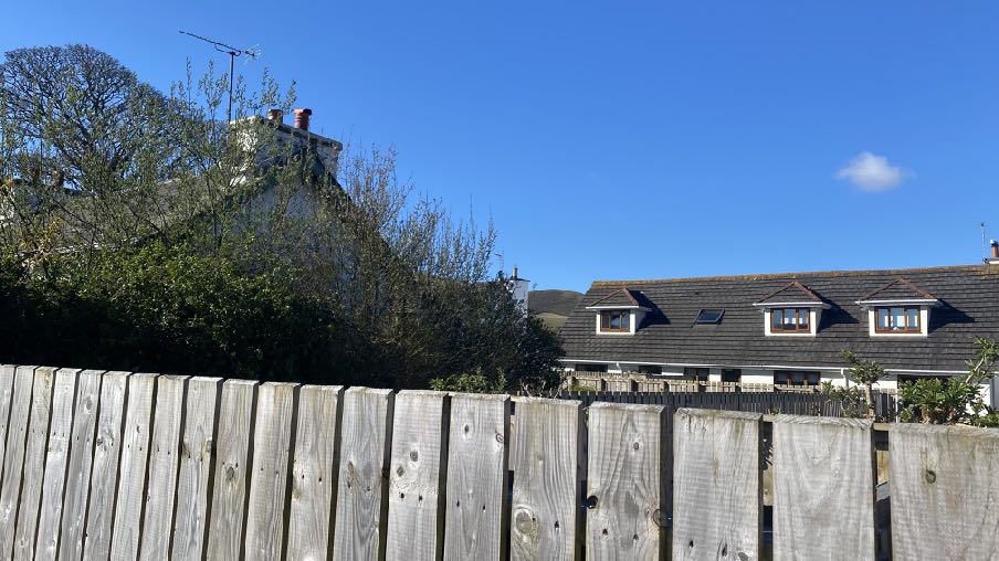
1.5 Riverside, an elongated single storey traditional building albeit significantly longer than the traditional footprint and having the appearance of a row of cottages, sits to the north of
the substation, the corner of the roadside gable of which can be seen in the photograph above.
1.6 To the rear of the property is Carrick Park, a relatively modern estate of properties. Those directly behind East View are dormer bungalows with numbers 6, 7 and 8 being visible from the main road. These have rendered walls, dark concrete tiled roofs with pitched roofed dormers within the rear pitches facing Mill View, East View and in the case of number 6 also faces the A3.
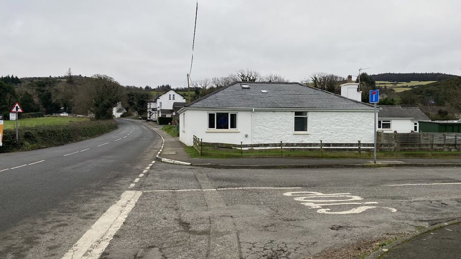
1.7 Elsewhere in the streetscene there is a hipped, slated roofed bungalow on the southern corner of the entrance into Carrick Park - The Shop (see below).
A photograph showing a wooden fence in the foreground with residential houses visible in the background, including a house with dormer windows.A white single-story bungalow situated at a road junction in a rural setting, featuring a grey slate roof and wooden fencing.
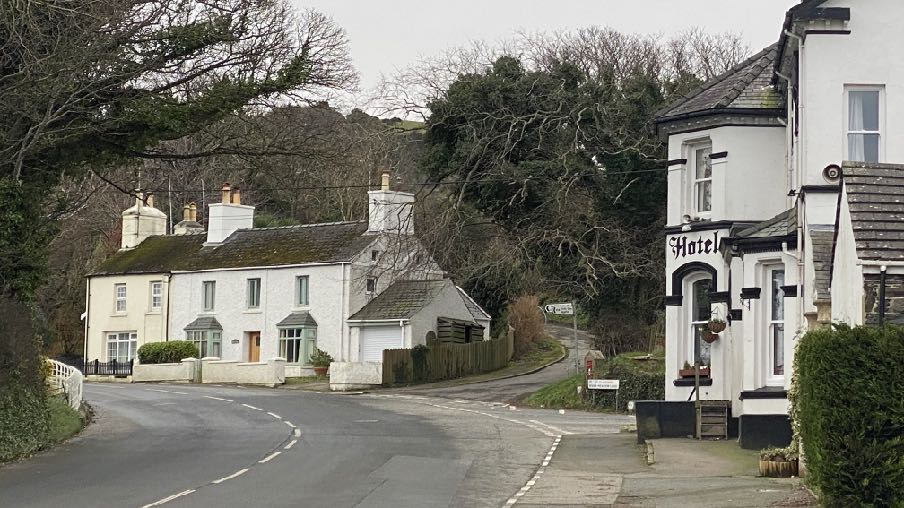
1.8 To the south of this is an open, hard surfaced car park beyond which is the Ginger Hall which has a detached single and two storey outbuilding with the main hotel building being a mix of single and two storey accommodation with windows serving the roof space, angled bay windows, curved headed window openings on the ground floor and vertical sliding sash windows throughout.
1.9 From the Ginger Hall, across the narrow road leading to the Claddaghs, known as River Meadow Land, is a pair of traditional Manx cottages - Lhen View and Holly Bank with the former having single storey angled bays not unlike those in the hotel.
1.10 The frontage of East View is currently a low stone wall with a now tall established hedge above.
1.11 The house has two floors of windows in the front elevation and no first floor windows in the rear elevation and no windows in either side elevation.
1.12 There is presently space for the parking of one vehicle as the existing garage has insufficient length to accommodate a full sized motor car and a vehicular opening onto the main road in front of the garage to the south of the main part of the dwelling.
A street-level photograph showing a white two-story house with an attached garage on the left and a building with a 'Hotel' sign on the right, situated at a road junction in a rural area.
2.0 The proposal
2.1 Proposed is the erection of a pair of semi detached dwellings on the site of the existing dwelling, East View, which is to be demolished. As the building is not protected by Registration or Conservation Area status, there is nothing to currently prevent the applicant demolishing the property, with the appropriate Demolition Notice under the Building Regulations.
2.2 The position and mass of the buildings are as proposed in the two most recent applications. The northern elevation has been modified to step out in part to add more interest to what was previously a blank elevation at first floor level with windows appearing on the ground floor on this side of the building with a further, small window sitting at first floor level serving a bathroom. This window will be fitted with obscured glazing and will be side hung, hinged on the western side such that a view out of it would not be possible other than towards the step out of the proposed dwelling, not any adjacent property.
2.3 This step out of the northern elevation projects 1.35m from the remainder of the northern elevation and glazing is contained within the eastern side of the projection, providing light and outlook to the bedroom at first floor level at this point. This glazing faces towards the road. Below it will be a door serving a porch which will be the entrance to this property.
2.4 The dwellings other than this northern elevation, remain as previously proposed. As before, the dwellings have been designed to reflect the range of architecture and designs of buildings in the vicinity in having predominantly traditional features and finishes other than a small section where the two properties meet which is finished in modern materials. We note the conclusion of the inspector in the case of her consideration of 24/00106/B that:
56. For the most part, the walls would be painted smooth render. However, the gable end to Dwelling B, which would sit adjacent to the main road, would be of a more contemporary design. Half would be in timber/composite cladding and the other half would be recessed to provide for a small balcony area at first floor level, facing east. The recessed part of the gable would be fully glazed. To my mind, the treatment of the roadside gable adds interest to the elevation, creating profile and light and shade. I consider the proposed design to be visually attractive. Whilst this element of the scheme is different, it is sufficiently respectful of the character of the surrounding area so as not to appear jarring or incongruous.
57. All told, I consider that there would be no harm to the character or appearance of the area as a consequence of the size, design or density of the dwellings proposed.
2.5 The more recent application was refused for reasons relating to the then proposed northern elevation which was considered to “undermine the architectural coherence and contextual sensitivity of the development. This alteration disrupts established vernacular character, weakening integration with the surrounding area, contrary to General Policy 2(b, c, g), which requires developments to respect local identity, scale, and form. Additionally, the proposal fails to meet Environment Policy 42, which mandates that new developments reflect existing architectural character, and Strategic Policy 5, which seeks high quality, contextually responsive design.”
2.6 It was also refused for reasons including one relating to the perceived lack of residential amenity of the occupants of those rooms in the first floor where there were to be no windows in the northern elevation. The proposed scheme has rearranged the internal floorspace so that each room now has access to a window: the bedroom has a window facing the road in the projecting annex, the bathroom has the high level window in the northern elevation.
2.7 We are unsure to what the reference in this reason for refusal is alluding where it states that “This design compromises both residential quality and passive security, contrary to General Policy 2(h), which requires developments to ensure appropriate living conditions, and General Policy 2(m), which emphasizes natural surveillance and personal safety.” The proposed design contained windows in the ground floor which would provide surveillance if it were needed, of the application site and there was a deliberate decision to avoid first floor windows so that the rear garden of 6, Carrick Park would not be overlooked.
2.8 The two proposed dwellings will both be three bed units both with bedrooms and bathrooms on the first floor, one half landing window in the rear of the southern unit rear elevation and with only one window in the first floor rear elevation - that in the southern unit serving a bathroom which will be fitted with obscured glazing. No criticism was expressed by either the planning officer or the appeal inspector in respect of this elevation and its impact on the neighbours or the amenities of those within the proposed dwellings.
2.9 As before, the dwellings have been orientated such that one faces the main road, to mirror Mill View, the property immediately to the south and the other with its gable to the road, reflecting the layout of Riverside, the nearest property to the north.
2.10 Again, both properties have provision for parking for two vehicles and for turning where the manoeuvring space in front of each dwelling is provided on a reinforced grass system which has the appearance of grass but allows for vehicles to turn upon it.
2.11 Both dwellings have a grassed rear garden which will be bounded by the existing, repaired fence behind which will be planted a new hedge. Both properties have a timber shed within which bicycles may be securely kept.
2.12 The existing entrance will be moved slightly northward and a new entrance serving the additional dwelling will be introduced to the north of this. Both entrances will have a drainage channel connected to the proposed surface water system to precent water discharging onto the highway.
2.13 No trees are to be removed to facilitate the development and the existing large tree to the south of the development will be protected during development by the introduction of a fenced Construction Exclusion Zone.
3.0 Planning History
3.1 The dwelling on the site was built prior to the introduction of the planning system. There was approval granted for extensions under 06/01940/B (see below) and permission was granted for the installation of replacement windows under 06/00800/B.
Approval granted for extensions under 06/01940/B
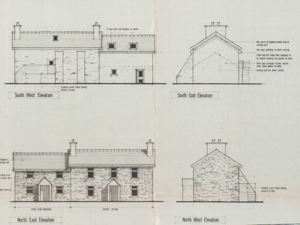
3.2 Following this, an application was submitted for the replacement of the existing dwelling (20/01452/B). This application, shown below, was refused for the following reasons:
The proposal is considered contrary to General Policy 2 b&c,g and Environmental Policy 42 and the recent Residential design guide 2021 as the design would be read at odds with the character of the surrounding streetscene and is considered over development for the site leading to an adverse visual harm with a perceived harmful
The image displays four architectural elevation drawings (South West, South East, North East, North West) of a proposed stone building with two distinct entrances.
impact upon the neighbouring properties. It is therefore concluded that the planning application is recommended for refusal.
Architectural elevations showing the front and rear views of a proposed two-story house with detailed material annotations and scale indicators.
3.3 Objections were received to this application from the owners of Hill View and 7 and 8, Carrick Park. These related to a range of issues including the impact on existing trees, the extent of the site in relation to land ownership, the impact of the proposal on light and privacy for the properties to the rear.
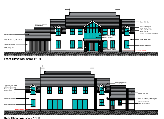
3.4 The most recent application on the site was 24/00106/B which proposed a pair of semi detached houses on the site:
3.5 This application attracted objections from the local authority and residents of two adjacent properties - 6 and 8, Carrick Park. Representations from the Highway Services Division of Department for Infrastructure, Ecosystems Policy Office, Manx Utilities and the Flood Risk Team all raised no objection to the application.
3.6 The planning officer recommended that the application was not acceptable and the proposal was refused under delegated powers on 17th July, 2024. The reasons for refusal were as follows:
R 1. Due to the overall density of development, layout of the individual plots, design and landscaping of buildings and the spaces around them, coupled with the quantum of development on the application site, the proposal is considered to result in a visual overdevelopment of the site. The scheme is also considered to be at variance with the context, character and appearance of this part of Sulby, which is defined by detached buildings laid out within medium sized plots, thus failing to comply with Strategic Policy 3(b), Strategic Policy 5, General Policy 2 (b, c & f), and Environment Policy 42 of the Strategic Plan.
R 2. The siting, height and design of the proposed second floor bedroom windows on the north elevation of the north facing semi-detached dwelling, which is proposed as part of the development would result in unacceptable levels of actual and perceived
The image displays four architectural elevations (Front/East, South, Rear/West, North) of a proposed two-storey residential building with detailed material annotations.
overlooking from the proposal site into the rear garden of 6 Carrick Park, to the detriment of the residential amenity, and contrary to General Policy 2 (g) of the Isle of Man Strategic Plan 2016, and the Residential Design Guide 2021.
3.7 An appeal was requested and the Minister agreed with the inspector’s conclusions that the proposal should be refused but for a single reason for refusal which was:
Whilst there is no objection in principle to residential development of this site, and nor would there be any harm to the established character and appearance of the area, there would be unacceptable harm to the living conditions of the occupiers of No 6 Carrick, Park with particular regard to privacy, prejudicing the use of the rear garden. That brings the development into conflict with General Policy 2(g) and (k) and the Residential Design Guide, which seek to protect such interests.
3.8 The inspector dismissed the concerns about the design and impact of the proposal on the streetscene and also objections on the grounds of over development. No concerns were raised in respect of flooding, parking, highway safety or drainage. Her conclusion is as follows:
I have found no harm in relation to the effect of the development proposed on the character and appearance of the area. Neither have I found any harm in relation to any window to window overlooking or outlook. I have, however, found that overlooking of the entirety of the rear garden to No 6 Carrick Park, and the consequent loss of privacy, would be unacceptable. That is not a matter that could reasonably be overcome by conditions. On balance therefore, for the reasons set out above, and having considered all matters raised, I conclude that the appeal should be dismissed and that the decision of the Authority to refuse planning permission be upheld.
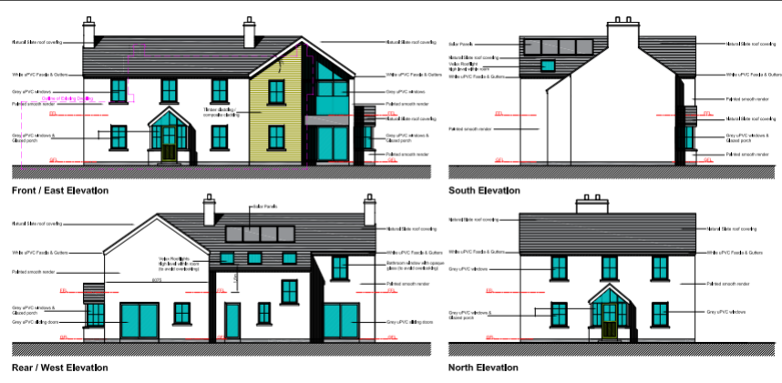
3.9 The most recent application on this site was also for a pair of semi detached two storey dwellings whose design attempted to overcome the reason for refusal at appeal, that concerning the overlooking of the rear garden of 6, Carrick Park - 25/90189/B. The first floor windows were removed completely in the northern elevation:
3.10 This application was not successful. There were three reasons for refusal. One related to the visual impact of the northern elevation and one to the amenities of those within the rooms served by the northern elevation and lack of outlook and natural light, leading also to a lack of natural surveillance and personal safety.
3.11 The third reason given for the refusal of this application was that the submitted Flood Risk Assessment did not sufficiently demonstrate that the development would not result in unacceptable risk of on or off site flooding or contribute unacceptably to increased flood vulnerabilities or intensify flooding in the area. Comment was also made that the FRA lacked any key technical assessments. Whilst flood risk had not previously been given as a reason for refusal, since the last decisions, the Government flood risk maps had been updated and showed different levels of flood risk for this property and that these new levels had not been satisfactorily addressed.
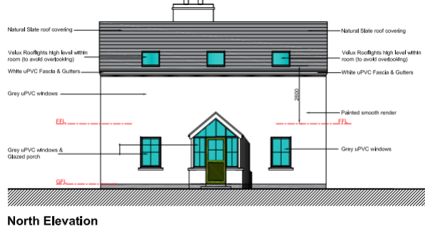
An architectural elevation drawing labeled 'North Elevation' detailing the proposed design of a house with material annotations for roofing, windows, and render.
4.0 Planning context
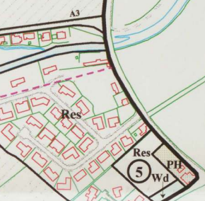
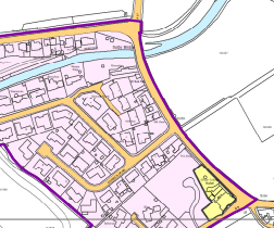
A cropped section of a site location plan showing existing residential properties and the proposed development site boundary marked with a number 5.A site plan showing a specific plot highlighted in yellow within a residential area, surrounded by existing housing outlines and boundary lines.
4.1 The site is designated for residential development in the Sulby Local Plan of 1998:
4.2 The draft Area Plan for the North and West confirms this designation:
4.3 Sulby is recognised as a village in the Strategic Plan settlement hierarchy and where development “should maintain the existing settlement character and should be of an appropriate scale to meet local needs for housing and limited employment opportunities”. Spatial Policy 4 also recommends that Area Pans should ring the development boundaries of such settlements so as to maintain their character.
4.4 Development is directed towards sustainable locations - ie settlements - under Strategic Policies 1, 2 and 10, Spatial Policy 5 and Housing Policy 4 of the Strategic Plan.
4.5 As well as promoting sustainable development, Strategic Policy 1 also encourages development to:
“make the best use of resources by:
(a) optimising the use of previously developed land, redundant buildings, unused and under-used land and buildings, and reusing scarce indigenous building materials and
(b) ensuring efficient use of sites, taking into account the needs for access, landscaping, open space(1) and amenity standards.”
4.6 As the site is within an area designated for residential use on the extant and emerging development plans, General Policy 2 is also considered applicable as follows:
Development which is in accordance with the land-use zoning and proposals in the appropriate Area Plan and with other policies of this Strategic Plan will normally be permitted, provided that the development:
(a) is in accordance with the design brief in the Area Plan where there is such a brief;
(b) respects the site and surroundings in terms of the siting, layout, scale, form, design and landscaping of buildings and the spaces around them;
(c) does not affect adversely the character of the surrounding landscape or townscape; (d) does not adversely affect the protected wildlife or locally important habitats on the site or adjacent land, including water courses;
(e) does not affect adversely public views of the sea;
(f) incorporates where possible existing topography and landscape features, particularly trees and sod banks;
(g) does not affect adversely the amenity of local residents or the character of the locality;
(h) provides satisfactory amenity standards in itself, including where appropriate safe and convenient access for all highway users, together with adequate parking, servicing and manoeuvring space;
(i) does not have an unacceptable effect on road safety or traffic flows on the local highways;
(j) can be provided with all necessary services;
(k) does not prejudice the use or development of adjoining land in accordance with the appropriate Area Plan;
(l) is not on contaminated land or subject to unreasonable risk of erosion or flooding;
(m) takes account of community and personal safety and security in the design of buildings and the spaces around them; and
(n) is designed having due regard to best practice in reducing energy consumption.
4.7 New dwellings should have an acceptable impact on highway safety and adequate parking (two parking spaces per unit) (General Policy 2, Transport Policies 4 and 7 and Appendix Seven).
4.8 Development must not result in any adverse impact on the living conditions of those in adjacent properties and guidance on how this may be assessed is set out in the Residential Design Guide (General Policy 2).
4.9 Developments should also take account of Climate Change and involve sustainable construction and renewable energy where possible and practicable.
4.10 No part of the application site is within a Conservation Area or contains buildings which are Registered.
4.11 Development which would increase the risk of flooding or be at unacceptable risk of flooding in itself is presumed against (Environment Policies 10 and 13 and General Policy 2). The flood risk maps both on the Flood Hub and the draft Area Plan for the North and West are difficult to detail due to their size and are difficult to helpfully replicate, but the site was previously shown to be affected in one part from fluvial flooding associated with the Sulby River which runs to the north of Riverside. The submission on 28.05.25 from the Flood Risk Management Division indicated that a map had been attached to their representation but none was published online.
4.12 The newly published flood maps now show all of East View and the surrounding properties including all of Carrick Park as being high or medium risk of fluvial flooding. The site itself is within an area of medium 1 in 100 year fluvial flood risk.
4.13 There are no Registered Trees on or near the site. Development which results in the loss of trees of amenity value is presumed against and development should take into account existing landscape features (Environment Policy 3 and General Policy 2).
4.14 Development is generally expected to have a positive impact on the character and appearance of an area and be of high quality of design and finish (General Policy 2, Strategic Policies 3 and 5 and Environment Policy 42).
5.0 Assessment
5.1 As was noted in the previous applications, the site lies within the settlement boundary of a defined settlement, in a sustainable location within reasonable walking distance of a shop, primary school, two churches, two public houses and the village hall. The site is also close to the Claddagh Recreation area and numerous public footpaths including the former railway line which links Peel to Ramsey.
5.2 Development of this site as proposed would satisfy Strategic Policies 1, 2, 10, Spatial Policy 5 and Housing Policy 4 in terms of sustainable development as was the case with the earlier application. The principle of residential development here is therefore acceptable.
5.3 The increase in the number of dwellings on the site would optimise the use of this sustainable site so in principle satisfies Strategic Policy 1a. Whilst concern was previously expressed by the planning officer about overdevelopment of the site, the inspector concluded that:
53. I recognise that the proposed dwellings would be semi-detached, whereas the other dwellings here are mainly detached, but I see no harm in that. Indeed, a little further along Lezayre Road to the south, Lhen View and Holly Bank comprise a pair of semi-detached dwellings adjacent to the road. I also saw detached properties sitting quite happily next to semi-detached dwellings around the Sulby Bridge bend.
54. The proposed properties would be much smaller than the Carrick Park dwellings, but then Mill View and East View are already much smaller. Moreover, the building footprints of each of the proposed dwellings are not greatly dissimilar to the existing building footprint for East View. On that basis, albeit that they are semi-detached, the two dwellings proposed would not, in my view, result in any material harm to the established character or appearance of the area. In coming to that view, I am mindful that they would not be visually ‘hemmed in’: Mill View to the south is set some way off the shared boundary, separated by a single-storey detached garage building and vegetation. Moreover, the site is not adjoined by buildings to the north, the rear garden to No 6 Carrick Park separating it from Riverside, roughly 30m away. There are no buildings opposite either, the site facing open fields.
5.4 The principle therefore of the erection of a pair of semi detached houses here is also acceptable.
5.5 It is important to consider the other elements of the proposal including car parking, access, drainage, flood risk, appearance and the impact on those in adjacent dwellings.
5.6 Car parking and highway safety
5.6.1 As previously proposed, the development provides two parking spaces per unit in accordance with the Strategic Plan standards. Each access has visibility of 70m from 2.4m in both directions. This is considered acceptable given that the speed of traffic is limited to 30 mph. The proposal is therefore considered to accord with GP2h and i and TPs 4 and 7 of the Strategic Plan.
5.6.2 The inspector discusses this following concerns raised by the local authority and concludes:
The Commissioners also raise concerns about parking provision and highway safety. However, two on-site parking spaces are proposed for each dwelling, in accordance with the standards set out in the Strategic Plan. The existing site access would be closed off and two new accesses formed, one at each end of the site frontage. As confirmed by Highway Services, who raise no objections on highway safety grounds, the visibility splays proposed are appropriate and there is sufficient space within the site to allow drivers to enter and leave in a forward gear. As for road closures during race periods, I am not persuaded that the net increase of one access to a single modest dwelling is likely to have a material impact in safety terms.
5.6.3 Car parking and access were not raised as reasons for refusal for the most recent application nor was there an objection from the Highway Services Division of Department for Infrastructure. As such, as the arrangements are not changed from that application, we assume that the development is acceptable as now proposed in respect of car parking and access.
5.7 Trees and vegetation
5.7.1 The proposal will result in the loss of the existing hedge which runs across the front of the site. This is not protected in any way and could be removed at any time without the need for any permission. The existing trees adjacent to the boundary with Mill View are not being affected by the development which moves the building on the site further to the north, away from it and a Construction Exclusion Zone is shown on the drawings to protect this tree during construction.
5.7.2 Additional trees - ash, birch, cherry and maple (native trees) and vegetation will be planted as show on the proposed site plan. As such, we believe that the proposal satisfies General Policy 2f and Environment Policy 3.
5.7.3 No issues appear to have been raised in this respect in the previous applications in this respect so we assume that the development continues to be acceptable in this respect.
5.8 Impact on the living conditions of those in adjacent dwellings
5.8.1 As with the previous applications, the properties closest to the site and most affected by the proposed development are considered to be Mill View and 6, 7 and 8, Carrick Park. Whilst Riverside is the next property to the north, it is over 30m away so is not considered to be directly affected by the proposed development. The planning officer’s only concern in the previous applications was for the living conditions of those in 6, Carrick Park in respect of the impact on those in adjacent property.
5.8.2 The inspector considered this and concludes as follows:
62. In terms of window to window distances, the rear, east facing elevation of No 6 Carrick Park contains three large dormers and a rooflight. As I saw during my site visit, the dormer nearest to the appeal site is to a bedroom, and below that, at ground floor level, is another bedroom window. However, they would be more than 20m away at their closest. 4 Moreover, views would be oblique, rather than direct. I find no material harm in this regard.
63. I recognise that the outlook for the occupiers of No 6 would change as a consequence of the development proposed, as it would for the occupiers of Nos 7 and 8 Carrick Park. However, there is already a dwelling on the plot, albeit currently overgrown. The appeal scheme would bring slightly taller built development closer to the site boundaries, but the overall modest scale of the proposed dwellings means that they would not be seen as unduly overbearing in their context. I find no material harm in this regard either.
64. I note concerns in relation the potential for noise from the proposed air source heat pumps. However, as confirmed by the planning officer, that is a matter that could be controlled by condition were the appeal to succeed.
65. To conclude on this issue, whilst I find no harm in relation to any loss of privacy in terms of window to window views, the relationship of the first floor bedroom and lounge windows with the rear garden to No 6 Carrick Park is such that the entire space would be directly overlooked, resulting in a material loss of privacy for the adjoining occupiers.
5.8.3 As the previous application was deemed acceptable in all respects other than the overlooking of the rear garden of 6, Carrick Park from the first floor windows, if any opportunity for unacceptable overlooking is removed, we would submit that the development should be considered acceptable in respect of its impact on adjacent property and occupants thereof.
5.8.4 There was no objection by the planning officer in the case of the most recent application in respect of the impact of the development on the living conditions of those in neighbouring property. What is proposed now introduces only two new windows compared with the most recently refused application. One of these windows faces the road and the other is a first floor window which will have the potential to overlook the rear garden of 6, Carrick Park. However, this window serves a bathroom so is unlikely to give rise to prolonged occupation or any desire for a view from this window. The window will be fitted with obscured glass and hinged so that the window opens outward towards the step out of the proposed dwelling. The impact of this is that anyone looking out of this window will have light and air but a view only of the rear of the proposed side projection and no view of the adjacent rear garden of 6, Carrick Park.
5.9 Living conditions of those in the proposed dwellings
5.9.1 The most recent application was refused for reasons including those relating to the living conditions of those in the proposed dwelling, namely the northern unit.
5.9.2 The application has been amended, following consultation with the planning officer, to rearrange the internal layout and to provide windows to both the bedroom and bathroom in this unit. Whilst we were content that the proposed roof light in the previous scheme was sufficient to provide light and ventilation to the bathroom, the planning officer indicated that this was unlikely to be acceptable, and as such, a window was added to serve the bathroom but designed and restricted so that a view over the adjacent property would not be possible.
We would still be content with a roof light but have amended the scheme in accordance with the advice provided.
5.10 Impact on and from flooding
5.10.1 The site was partly within an area at risk of fluvial flooding associated with the Sulby River. A Flood Risk Assessment was provided as part of the first application for the semi detached houses which demonstrated why the proposed development is not at risk from flooding nor will increase the flood risk to other areas and the proposal was considered to have satisfied General Policy 2l.
5.10.2 The inspector considered this and concluded as follows:
66. Whilst a small part of the site is identified as being at risk of flooding, I note that the adjacent main road, which rises here, is not included within the area of flood risk. In any event, the appellant’s Flood Risk Assessment confirms that the floor level of the proposed dwellings would be 0.21m above the existing ground floor level, some 0.2m above the level of the adjacent road. It also confirms that the property benefits from flood defence works carried out in 2005. I am mindful, in this regard, that the DoI Flood Risk Management Team raises no objection. Whilst I note the comments of the Commissioners in relation to flood risk, there is no substantiated evidence before me to support their concerns.
5.10.3 The situation has now changed, however, as the flood risk maps have been updated and a much wider area is considered to be of higher risk of fluvial flooding. The Flood Risk Management Division acknowledges this in their objection to the most recent application. Their concern was that the application had not demonstrated that the development would not unacceptably increase the risk of flooding to other properties surrounding the site due to the increase in footprint from what exists which could impact the flows and depths surrounding the site. They also expressed concern that the increased in paved surface and discharge of this to soakaways where no percolation tests had been undertaken. They recommended that such tests were done prior to any determination and that water from the proposed hardstanding was not washed to adjacent properties.
5.10.4 We have provided an updated Flood Risk Assessment which confirms that the increase in floor area from the existing is 40 sq m. It also explains that the northern and
western boundaries will continue to be bounded by fencing and the eastern and southern by stone walls.
5.10.5 It explains that, as was the case with the previous applications, that surface water is proposed to be either discharged to a soakaway or if tests prove unsatisfactory, to the main public surface water sewer located at the junction of the main road and Carrick Park. Attenuation prior to discharge to the main system was not previously required but could be provided. It is not thought that the existing dwelling is connected to the main surface water sewer and it is unlikely that any historic soakaways would still be functional and there is no evidence of any drainage channels at the entrance to the site nor any flood prevention measures on site.
5.10.6 It is difficult to undertake percolation tests at the present time due to the condition of the existing buildings and extent of vegetation. A condition could be attached to require, prior to any development commencing, that percolation tests are undertaken and the full design of the means of disposal of surface water from the site approved by the Department to ensure that this aspect of the development is acceptable.
5.10.7 The property as it currently exists benefits from Permitted Development which could result in the following additional floor area: up to 35 sq m of extension, up to 15 sq m of shed or summerhouse. There is also no restriction on paving within a residential curtilage nor any control over the erection of non permeable walling up to 1m or 2m depending on its location, within the property.
5.10.8 As such, the existing property could be extended and curtilage structures built such that the amount of floor area resulting from the proposed development could be achieved without any permission being required. Also, if impermeable walls were erected around the perimeter of all of the site which could exclude water from the site up to 477 sq m of site area.
5.10.9 We would submit that as proposed the development would not materially or unacceptably increase flood risk to neighbouring properties any more than the risk presented by the existing property together with its potential for expansion and additional development under the Permitted Development provisions. The proposed boundary treatment will continue to allow the free movement of flood water should there be any, through the site resulting in no increase. We would be happy to accept conditions restricting
any further extensions, walling or curtilage structures, should this be considered appropriate and necessary.
5.10.10 All vulnerable accommodation (bedrooms) are on the first floor and outwith any flood risk area.
5.11 Impact on the streetscene
5.11.1 The proposal has been designed to acknowledge the mixed styles of buildings in the streetscene but with a predominance of traditionally styled buildings which front onto the A3. What is proposed incorporates mostly traditional features, proportions and character but with a small area of more modern intervention. The orientation of buildings alongside the A3 also varies with some properties facing directly onto the road and others having their gables facing it. Some have both (The Shop and the Ginger Hall). There are also both semi detached and detached properties in the vicinity within the same streetscene.
5.11.2 We believe that, as with the previous schemes, the proposed development incorporates the positive features of the surrounding area and will have a positive impact on the character and appearance of the area. It is important not to replicate existing buildings so that an area has no sense of identity and what is proposed provides something that is both unique but sympathetic to its context. As such we would submit that the property satisfies General Policy 2b, c and g, Environment Policy 42 and Strategic Policies 3 and 5 as well as the design guidance in the RDG.
5.11.3 The impact on the streetscene was considered by the inspector who concluded that:
56. For the most part, the walls would be painted smooth render. However, the gable end to Dwelling B, which would sit adjacent to the main road, would be of a more contemporary design. Half would be in timber/composite cladding and the other half would be recessed to provide for a small balcony area at first floor level, facing east. The recessed part of the gable would be fully glazed. To my mind, the treatment of the roadside gable adds interest to the elevation, creating profile and light and shade. I consider the proposed design to be visually attractive. Whilst this element of the scheme is different, it is sufficiently respectful of the character of the surrounding area so as not to appear jarring or incongruous.
57. All told, I consider that there would be no harm to the character or appearance of the area as a consequence of the size, design or density of the dwellings proposed. There would be no conflict, in this regard, with Strategic Policy 3(b), Strategic Policy
5, General Policy 2 (b), (c), (g) and (f) and Environment Policy 42, which together and among other things seek to protect the character, appearance and identity of an area. There would be no conflict either with the Residential Design Guide, which encourages good quality, contemporary design where it is informed by, and is respectful of, its context.
5.11.4 The current application retains the majority of the previous proposal in all but the northern elevation. The criticised appearance of this elevation has been improved by the introduction of a small projection which adds interest to the facade without adding additional opportunities for overlooking of the adjacent properties through the appropriate design and treatment of the only first floor window proposed in this elevation. We believe that this satisfactorily resolves the concerns of the planning officer in respect of this aspect of the previous application.
6.0 Conclusion
6.1 We believe that the proposal optimises the use of this sustainable site in a recognised settlement in a way that is sympathetic to its surroundings and will provide two, thermally efficient dwellings which satisfy the requirements of the Strategic Plan and the Residential Design Guide whilst enhancing biodiversity through the introduction of new planting.
6.2 The amendments now proposed to the northern elevation will remove any opportunity for overlooking of the rear garden of 6, Carrick Park but will retain satisfactory amenity of the occupants of the northern dwelling, thus addressing the reasons for refusal of the previous application in those respects.
6.3 The Flood Risk Assessment has been updated to address the new flood risk maps and the reasons for refusal and concern expressed with the most recent application.
6.4 We believe that the proposal satisfies all of the relevant planning policies and represents an acceptable form of development which will enhance the streetscene and provide two well designed new dwellings in a sustainable location in an established settlement.
Sarah Corlett 16.10.25
Copyright in submitted documents remains with their authors. Request removal
Source & Provenance
Official reference
25/90974/B
Source authority
Isle of Man Government Planning & Building Control