Loading document...
22000048
January 2022
Between 1990 and 2003 former sand quarries at the Point of Ayre (POA) were utilised by Departments of the Isle of Man Government for the deposit of mixed household, commercial and industrial waste.
In 2017 the Department of Infrastructure commissioned a study on the provisions for groundwater monitoring across the PoA complex of landfill sites. The ensuing report recommended the installation of additional groundwater and gas monitoring boreholes.
16 new boreholes were installed in 2018, and existing BHs refurbished. Installation of BHs on the Isle of Man constitutes development which, under the Town and Country Planning Act 1999, requires planning permission. This planning application therefore seeks retrospective permission for the installation of the POA boreholes.
Contents
1 Introduction and Background 4 2 Need for the Planning Application 6 3 Location and history 7 4 Site Description and Environmental Setting 9 5 Need for the POA Landfill Complex Boreholes 11 6 Environmental Impact 14 7 Policy considerations and assessment 15 8 Summary 18
Appendices
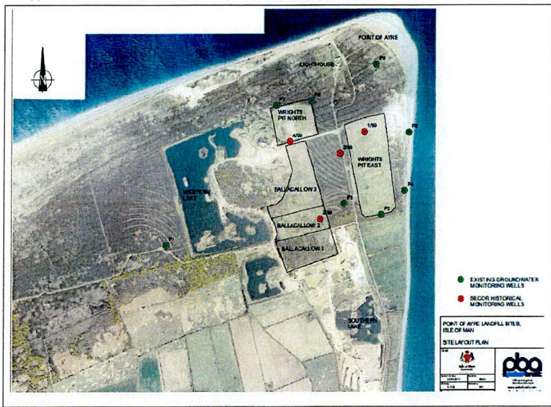
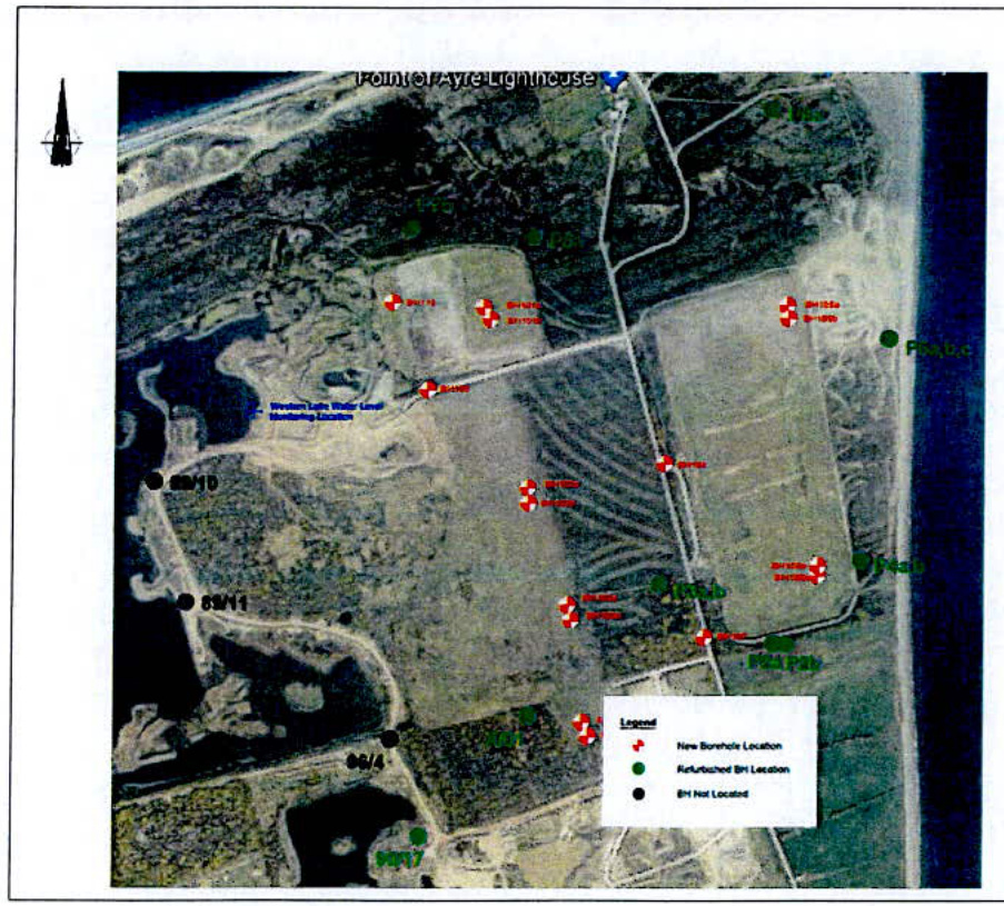
1 Location of the Point of Ayre Landfill Complex 2 Location of New (2018) and Refurbished Boreholes 3 POA All Groundwater Monitoring Borehole – grid references 4 2017 Isle of Man Landfill Monitoring Review Point Of Ayre Landfill Sites – Initial Document Review’ extract 5 Methodology for Borehole Development 6 Sample Borehole Log 7 Boreholes 106a and 106b Following Installation in 2018 8 Boreholes 106a and 106b taken from adjacent to Wright’s Pit East August 2020 9 Pre 2018 groundwater monitoring BH 10 Borehole Development – site management, measures to protect the environment and operatives 11 POA Closed Landfill Sites Complex – Example of Leachate Plume Modelling 12 Two Year POA BH sampling 13 CCG POA BH Development Risk Assessment
1.1 In 2015 Department of Infrastructure (DOI) commissioned an initial scoping study on its closed and operational landfill sites. The purpose of the Study was to assess current landfill monitoring provision against the regulatory and industry best practice in other jurisdictions, and to assist the DOI prioritise further work on landfill site managing and monitoring. 1.2 The Study report, "Isle of Man Landfill Monitoring - Scoping Report for the Isle of Man Government 2016)" recommended a more detailed study be undertaken on the Point of Ayre landfill complex (PoA complex) to
1.3 In May 2017 the 'Point Of Ayre Landfill Sites - Initial Document Review' was issued. This recommended the installation of six new boreholes (BHs) within the landfill sites to permit monitoring of the source zone leachates, with a further three new perimeter boreholes to 'fill in' some gaps in the existing perimeter network. The addition of the new wells (BHs) would then provide a suite of 23 groundwater / leachate monitoring wells. The report also advised the installation of 'one or more additional 'background' boreholes, up hydraulic gradient of the landfill sites may also be required in future, particularly if borehole P1 is no longer viable.' 1.4 An initial BH screening programme was recommended together with a list of determinants (chemicals/chemical compounds and metals) the groundwater should be tested for, the aim being to ' establish a 'chemical fingerprint' of the source zone leachates and permit monitoring of the leachate plume.' 1.5 Following a review of groundwater and leachate levels it was agreed that at each monitoring location 2 BHs should be developed, one in waste and one below waste level. 1.6 In 2018, following a tendering process, the fieldwork for BH installation was carried out in accordance with the 'UK Specification for Ground Investigation': 2nd Edition: 2011, and BS10175: 2011, BS5930, and BS EN 1997-2: 2007 Eurocode 7, insofar as they related to the scope of the work were installed and existing BHs inspected between 20th November 2018 and 13th December 2018.
[^0] [^0]: GROUNDSOLVE LIMITED included in report GROUND INVESTIGATION ON LAND AT WRIGHTS PIT LANDFILL FACILITY CRANSTAL ISLE OF MAN IM7 FEBRUARY 2019
1.7 To summarise the works consisted of:
Since 2018 the BHs have been used to provide groundwater composition and groundwater flow data, and to model leachate flows.
2.1 The need for planning permission for each BH was advised by the DEFA Planning and Building Control after the BHs were installed. Unlike England, the IOM does not have permitted development regulations for installation of groundwater monitoring BHs. The DEFA has advised that, until regulated by way of a planning permission, the data collected via the 2018 BHs cannot be relied upon as evidence in any planning application. Installation of BHs on the Isle of Man constitutes development which, under the Town and Country Planning Act 1999, require planning permission. 2.2 This planning application is for retrospective permission to install 16 groundwater monitoring boreholes on land at the PoA (locations identified on Map 1). The BHs are to remain in situ until the landfill sites are considered by the IoM Government body responsible for environmental protection as non-bioreactive and the groundwater deemed to no longer require monitoring.
3.1 The POA is located in a relatively remote area at the Point of Ayre, the most northerly part of the Isle of Man. There are five separate landfill sites which form the POALS. These are Wrights Pit North and Wrights Pit East and Ballacallow 1, 2 and 3. 3.2 Wrights Pit North is centred at approximate National Grid Reference NX 463045 whilst Wrights Pit East is centred at approximate National Grid Reference NX 466 044. At their closest, the sites are about 200 m apart. 3.3 Ballacallow 1, 2 and 3 landfills are located to the south of Wrights Pit North and to the west of Wrights Pit East and are centred at approximate National Grid Reference NX 463 044 . 3.4 The small village of Cranstal lies approximately 1.5 km south of Wrights Pit East landfill and the Point of Ayre Lighthouse, the closest building to the site, is located approximately 350 m to the north east of Wrights Pit North. At its closest point, the coastline lies approximately 100 m to the east of Wrights Pit East and about 350 m north of Wrights Pit North. 3.5 The topography of the Point of Ayre is low lying and flat, the ground level immediately adjacent to the site lies at an elevation of approximately 7.0 to 11.0 m above Ordnance Datum (m AOD).
3.6 The PoA landfill complex comprises one active and four closed landfill sites. The active landfill site, Wrights Pit North, is the subject of a current planning application. The four closed landfill sites are, in order of time operated, Ballacallow 1, Ballacallow 2, Ballacallow 3, and Wrights Pit East. These closed landfill sites were used for the disposal of mixed industrial, commercial and household waste from across the Island. There are no formal records of the tonnages and types of waste deposited at these landfill sites. It is estimated that up to 2 m tonnes of waste was deposited.
3.7 The history of the sites and their development history are complex. All of the five landfill sites were formerly mineral workings developed to enable extraction of sand and gravel. Two further mineral extraction sites abut the POA; one disused to the west / south west of Wrights Pit North and another still operational to the south of Wrights Pit East. Part of the gravel workings to the west has been restored to a large lake (the Western Lake). 3.8 Following extraction of the minerals, the sites were utilised for landfilling of wastes. None of the landfill sites were developed using engineered containment. All sites rely on the principle of attenuation and dispersion to minimise environmental contamination, also known as 'dilute and disperse'. 3.9 Each landfill has been formed in a number of individual landfill cells. All of the landfill cells are unlined and in the absence of any form of engineered containment, it is assumed
that the cells are not hydraulically isolated from each other and that they are in hydraulic continuity with the surrounding groundwater. Table 1 PoA complex - chronology.
| Landfill Site | Waste Types Received | No. of Cells | Date Opened | Date Closed | Restoration |
|---|---|---|---|---|---|
| Wrights Pit North | Inert construction, demolition and civic amenity waste, ‘problematic waste’ – asbestos. | 2 | 2002 | Still open (western cell only) | Eastern cell – to Gallic Heath |
| Wrights Pit East | Domestic refuse, commercial and industrial waste, civic amenity waste | 4 | 1997 | 2004 | 2005 to Gallic Heath |
| Ballacallow 1 | Domestic refuse | 3 | 1976 | 1991 | Complete – to Gallic Heath |
| Ballacallow 2 | Domestic refuse | 3 | 1991 | 1993 | Complete – to Gallic Heath |
| Ballacallow 3 | Domestic refuse | 2 | 1995 | 1997 | Complete – to Gallic Heath |
4.1 Wrights Pit North is the only operational POA landfill site and is the subject of a planning application, PA21/01000/B. It is approximately rectangular in shape with average dimensions of . The mineral extraction extended to a depth of about 2 m AOD and two east-west oriented landfill cells were created within the resultant void. The eastern cell has been completely filled and restored to Gallic Heathland. The western cell is currently being filled and represents the only active waste facility within the PoA complex. 4.2 The western cell of Wrights Pit North is currently being filled with inert construction and demolition wastes, civic amenity wastes (green waste, wood, paper, glass metal etc.) and 'problematic wastes' including asbestos. Domestic refuse, incinerator bottom ash (IBA) and industrial waste is not permitted to be deposited at Wrights Pit North. We understand that household or garden chemicals which could contain hazardous substances are removed prior to disposal, although the means by which this is accomplished is unclear - see s.5.45 of the Wrights Pit North Planning Application and Environmental Statement (SLR 2012).
4.3 Wrights Pit East lies about 200 m to the east of Wrights Pit North and is a closed municipal waste landfill that has been restored back to Gallic Heathland. The site measures some and is primarily a land-raise, with some limited excavation and below ground tipping having taken place to a shallow depth. The site was the main municipal landfill on the island during its operation. Wrights Pit East is formed of four landfill cells which are oriented north-south. Being a land-raise site, Wrights Pit East forms a distinct topographic feature in an area of otherwise flat, low-lying ground. It is understood that the maximum final (pre settlement) restoration level, including beach ridges, of Wrights Pit East was around 12.5 m AOD (Wilson 2003). This compares to natural levels of around AOD in the surrounding ground (Wilson 2003).
4.4 The Ballacallow landfills are located immediately to the south of Wrights Pit North and about 200 m to the west of Wrights Pit East. 4.5 Ballacallow 1 is the southern-most landfill and was the earliest to be filled. The site is approximately rectangular and measures some . It comprises three east-west oriented landfill cells. 4.6 Ballacallow 2 is located centrally and comprises three east-west oriented landfill cells. The site is approximately rectangular and measures some . 4.7 Ballacallow 3 is the northern-most of the Ballacallow landfills. It was the last of the three Ballacallow sites to be filled and abuts Wrights Pit North which is just to the north. The site is irregular in shape but measures approximately at its widest point. There are two landfill cells oriented north-south.
Geology 4.8 The PoA complex and its environs are immediately underlain by glacial sands and gravels of the Point of Ayre Formation (formerly known as the Ayre Beach Deposits). These deposits comprise sand and gravel beach ridge deposits formed during periods of higher sea levels and are typically 7 to 15 m thick. The deposits are of Quaternary (Holocene) age. The Point of Ayre Formation deposits have historically been and are currently being worked by the mineral extraction operations in the area. 4.9 Beneath the Point of Ayre sands and gravels, Quaternary (Devonian) age glacial deposits of the Orrisdale Formation are encountered. These deposits are typically characterised by silts, sands and fine to medium gravel overlying stiff brown silty clay (probable Boulder Clay). These materials were formed as ice margin deposits - gravel, sand, mud and diamicton and are likely to have been deposited on out-wash plains beyond endmoraines during the last glacial period. The Boulder Clay is present at depths of about 20m below ground level and has been proven to be at least 5 m thick. 4.10 Beneath the Orrisdale formation, the geology comprises Permo-Triassic Strata of the Mercia Mudstone Group. These formations are present at about -125 m OD.
'All sites except Wrights Pit North received largely domestic refuse during their operational lifetime. Wrights Pit North is not licenced to receive domestic refuse and takes largely construction and demolition waste, inert waste, civic amenity waste and some 'problematic waste' - asbestos. None of the landfill sites were designed with engineered containment and therefore function on a 'dilute and disperse' basis.
There is currently a network of 14 perimeter groundwater monitoring wells at 8 locations around the POALS. These are sampled on an annual basis (since 2003) and tested for a range of basic water quality parameters and some heavy metals. Having reviewed the historical groundwater data and particularly the ammonium data (which is a good indicator of the presence of landfill leachate), it is evident that the groundwater in the vicinity of the POALS has been impacted by a substantial landfill leachate plume. There is evidence that the plume has been growing both in extent and concentration over the years and it seems likely that it has reached the sea on the east coast. Extension of the plume to the north seems to be more limited.
Concentrations of ammonium in the groundwater are, in places, very high - of the order of 60-90 in boreholes P3, P4 \& P6. Whilst the development of a leachate plume is not perhaps surprising, given that all of the landfills were constructed without engineered containment and operate on a 'dilute and disperse' basis, there is relatively little information on what contaminant loading the plume might contain.
Very little contamination analysis has been carried out and virtually no analysis is available to describe the source zone leachates within each of the landfills themselves. What contamination analysis is available dates largely from 1997-1999. Analysis of these data indicate the presence, sporadically, in the groundwater of generally low concentrations of hydrocarbons, poly aromatic hydrocarbons (PAHs), volatile hydrocarbons, chlorinated solvents, disinfectants, some herbicides and pesticides and, of course, in the recent analysis, low concentrations of PCBs.
A single analysis of a source zone leachate is available from 1999 from Ballacallow 2 (2/99) and this reveals the presence of ammonium at a concentration of and, in addition to many of the compounds described in the previous paragraph, very heavy diesel range hydrocarbon contamination at concentrations sufficient to suggest the presence of free phase product (oil floating on the water table) at the time of sampling.
It is essential in our view to construct additional monitoring boreholes within each of the landfill sites (we have recommended initially six additional boreholes) to allow the character of the source zone leachates to be properly investigated and the key contaminants of concern determined.
The existing perimeter monitoring wells would be suitable for continued monitoring though we have recommended the construction of a further three additional boreholes to 'fill in' some gaps in the monitoring network. One or more additional 'background' boreholes may also be required, particularly if borehole P1 is no longer viable.
Similarly we have recommended additional analysis of the perimeter monitoring wells to allow the extent and levels of contamination in the leachate plume to be properly investigated and key contaminants of concern determined
The processes of initial leachate characterisation and plume monitoring would ultimately enable IOMG to establish a long term monitoring regime for the site which would inform future risk assessments and assessments of potential remedial measures which might be required to treat or manage the leachates or the leachate plume emanating from the POALS.
In respect of specific site waste management licencing conditions, it would appear that Wrights Pit North and East have not been managed fully in accordance with their licence conditions and the requirements of the sites' working plan in that the provisions set out in those documents for groundwater monitoring have not been fulfilled. This might have implications for the continued management of Wrights Pit North which is currently still operational and accepting wastes.'
'Six new boreholes are constructed within the landfill sites themselves to permit monitoring of the source zone leachates, with a further three new perimeter boreholes to 'fill in' some gaps in the existing perimeter network. With these new wells there would be 23 groundwater / leachate monitoring wells in total available for sampling. One or more additional 'background' boreholes, up hydraulic gradient of the landfill sites may also be required in future, particularly if borehole P1 is no longer viable.
A physical inspection of the existing network of groundwater monitoring wells should be undertaken to determine what remedial action is needed to ensure that they are suitable for sampling. It should be recognised however, that such inspections may reveal that additional boreholes will need to be installed as replacements if the existing wells functionality cannot be satisfactorily determined. During this process it would be useful to attempt to locate the SECOR (1/99 - 4/99), loMG Laboratory (BH1 - BH18) and RMC boreholes, if they still exist. The existing network of landfill gas monitoring wells may also be of use in future groundwater monitoring programmes, again, subject to inspection.
The scope of the initial screening exercise will depend upon the budget available and this must be agreed with loMG before the monitoring plan is finalised. However the plan's aims must be to establish a 'chemical fingerprint' of the source zone leachates and permit monitoring of the leachate plume.
For initial leachate characterisation, we propose full characterisation analysis of six new landfill leachate boreholes with two additional samples from two of the perimeter boreholes - such as P3 and P6.
In respect of plume monitoring, inexpensive indicator compound testing (ammonia, for example) could be used to map the plume and, if the budget allowed, some additional analysis for key contaminants could be carried out at the same time. Multi-residue screening might have an application here as a relatively inexpensive way to screen a large number of potential contaminants.
Plume monitoring from the outset across all of the available boreholes is very important in our view as this will allow us to obtain a better understanding of the extent of the leachate plume and the way in which it continues to develop over time. In turn this should inform any future fate and transport studies that may be required once the key contaminants of concern in the source zone leachates have been established.
We recommend, in line with current UK best practise, that the initial leachate characterisation and screening exercise is undertaken on a quarterly (3-monthly) basis over a period of 36 months such that a total of 12 sample sets from each monitoring well are obtained. '
5.3 On the basis of this recommendation the DOI commissioned the installation of groundwater monitoring BHs across the POA to supplement the existing BHs. It is intended that these BHs will be utilised for monitoring groundwater composition and model flow direction until such time as it is advise that the landfill sites no longer pose a potential risk to the environment.
6.1 Detail of works undertaken by Groundserve are included in its report CC Geotechncial Report CCG-C-18-10640: Ground Investigation on land at Wrights Pit Landfill Facility, Cranstal, Isle of Man. IM7 4BS: February 2019, extracts of which are included in Appendices 3-6,10 and 13. 6.2 The potential for detrimental impacts on the environment are during and following BH installation a. during BH installation
The DOI contractor reviewed industry best practice and carried out a risk assessment for potential harm to the environment and health during installation of the BHs. This is included in Appendix 13. The measures taken to address identified risks are summarised in Appendix 10
Prior to the works being undertaken the DEFA Environmental Protection Unit was consulted and officers carried a site inspection of the BH drilling works. DEFA raised no objections to the works. b following installation Visual impact The BHs were installed taking account of the most contemporary advice regarding BH installation for groundwater monitoring. Unlike pre 2018 BHs (Appendix 9) these BHs are not flush to the ground but raised, with a lockable well cap. The need for raised BHs is to avoid BHs caps being overgrown by vegetation, buried by sand or soil, or impacted by animal activity. 6.3 Appendix 6 shows BHs 106 a and 106b just after installation in 2018. Appendix 7 shows the same BHs in August 2020. The BHs are barely visible from adjacent paths used by the public, and not visible from distant views. The closed landfill sites are not intended for public access and as such the BHs should not be noticeable. The only exceptions being BHs 107, 108 and 109 which are adjacent to the landfill sites, in the road verge. 6.4 As an area of former landfill sites it would generally be expected that the area was subject to monitoring of the groundwater. As such these features should not be incongruous. 6.5 Since 2018 the new and existing BHs have been used to obtain information on the chemical composition of groundwater at the POA. An example of data obtained from groundwater sampling is included in Appendix 12. Appendix 11 shows how the data is used for Leachate Plume Modelling.
7.1 The policy context for installation of groundwater monitoring boreholes is the Isle of Man Strategic Plan 2016 (the Strategic Plan), the 1982 Development Plan and the 2018 Waste Strategy. The Public Health Act 1990 sets to regulatory context for monitoring closed and active landfill sites.
2016 Strategic Plan 7.2 The strategic aim of the 2016 Strategic Plan (SP) is to 'To plan for the efficient and effective provision of services and infrastructure and to direct and control development and the use of land to meet the community's needs, having particular regard to the principles of sustainability whilst at the same time preserving, protecting, and improving the quality of the environment, having particular regard to our uniquely Manx natural, wildlife, cultural and built heritage.' 7.3 The SP para 12.1.7 The Government Plan 2006/09 Quality Environment Aim, states the objective is to "To dispose of the Island's wastes in a safe, effective and efficient manner. 7.4 The installation of BHs supports this aim by facilitating the monitoring of historic and current waste disposal. This is to ensure that emissions from waste decomposition pose no unacceptable risk of harm to the environment or adjacent land users. 7.5 Local and site specific proposals will, generally, remain the subject of Area Plans, which for the POA is the 1982 IOM Development plan. The POA is identified as an area of high landscape or coastal value and is not zoned for development. For development outside of areas zoned for development, 2016 SP states: 'General Policy 3: Development will not be permitted outside of those areas which are zoned for development on the appropriate Area Plan with the exception (e) location-dependent development in connection with the working of minerals or the provision of necessary services; g) development recognised to be of overriding national need in land use planning terms and for which there is no reasonable and acceptable alternative; 7.6 SP, Environment Policy 1, also states that 'The countryside and its ecology will be protected for its own sake.' ' Development which would adversely affect the countryside will not be permitted unless there is an over-riding national need in land use planning terms
which outweighs the requirement to protect these areas and for which there is no reasonable and acceptable alternative.' 7.7 The BHs are necessary and are site specific development directly associated with the former use of land for the disposal of mixed household, industrial and commercial wastes. There is no alternative method for monitoring groundwater. The development does not therefore conflict with SP policies GP3 or EP1. 7.8 The BH development supports SP Strategic Policy 4, This states that 'Proposals for development must: (b) protect or enhance the landscape quality and nature conservation value of urban as well as rural areas but especially in respect to development adjacent to Areas of Special Scientific Interest and other designations; and (c) not cause or lead to unacceptable environmental pollution or disturbance.' 7.9 The BHs facilitate the monitoring of closed and active landfill sites. This acts to protects the nature conservation value of the area including the Area of Special Protection for Birds, and aims to ensure the landfill sites do not cause, or lead to, unacceptable environmental pollution. 7.10 SP Environment Policy 2 states that 'The present system of landscape classification of Areas of High Landscape or Coastal Value and Scenic Significance (AHLV's) as shown on the 1982 Development Plan and subsequent Local and Area Plans will be used as a basis for development control until such time as it is superseded by a landscape classification which will introduce different categories of landscape and policies and guidance for control therein. Within these areas the protection of the character of the landscape will be the most important consideration unless it can be shown that: (a) the development would not harm the character and quality of the landscape; or (b) the location for the development is essential. ' 7.11 The BHs are an essential mechanism for monitoring the groundwater across an area of contaminated land and are location dependent. Due to their size the BHs cannot be considered to harm the character and quality of the landscape. 7.12 The activity of BH development is an engineering operation, albeit undertaken over a very short period of time. Steps were taken during drilling and installation to ensure there was no damage to the restored landfill surface and restoration ecology. To this extend the development accorded with SP Environment Policy 5 as an exceptional circumstance under which development is allowed which 'could adversely affect a site recognised under Environmental Policy 4' however conditions imposed on the contractor undertaking the works, and monitored by an independent site supervisor, ensured that disturbance was minimised and ecological interests were conserved. 7.13 Paragraph 7.20 of the SP, Contaminated Land, states that 'Contaminated land on the Island is typically as a result of the legacy of past industrial and chemical land uses. Perhaps the most notable sites are land areas associated with former mining practices and it is not uncommon for such sites to be close to residential areas or watercourses which can be detrimentally affected by such contamination. The practice of reclaiming contaminated land and bringing it back into beneficial use is supported, whether it be suitable in the end
for open space or residential development or as deemed appropriate in the Area Plans. It is important that however former contaminated land is utilised, both health and property are safeguarded. Detailed surveys may be required to identify the extent of contamination and how contamination problems can be overcome. 7.14 The installation of groundwater monitoring BHs across the area of contaminated land at the POA are essential to support the beneficial use of the area as a nature conservation area, and specifically its future incorporation within the Manx Birdlife nature reserve.
7.15 The WS Core Policy relevant to this application is Policies 1 which states
The management of waste (its collection, transportation, storage, processing, and disposal) has the potential to cause harm to the environment and people, now and in the future. It is imperative that a 21 st century waste strategy reflects the need to protect the Islands habitats and people from harm, and to identify and address issues relating to historic waste disposal.
The Departments of Isle of Man Government will identify, monitor, and where necessary manage areas of historic waste disposal.
The installation of BHs at the Point of Ayre Complex is therefore in accordance with the Policy 1 of the 2018 Waste Strategy
7.16 Section 59 of the 1990 Act 'Licences to dispose of waste' states that ' (1) An application for a disposal licence in respect of any land shall be made in writing to the Department and include such information as is prescribed. Section 60 states that 'A disposal licence may include such conditions as the Department sees fit to specify in the licence; and such conditions may (among other things) relate to ' (h) the works to be carried out or other action to be taken, in connection with the land, plant or equipment to which the licence relates, before the activities authorised by the licence are begun, while they are continuing or after they have ceased;' 7.17 Post closure monitoring of landfill sites for the duration of time they remain a potential source of harm to the environment is best practice. For biodegradable waste this is the period the landfill remains bio-reactive and can be hundreds of years. There are no records of the types and tonnages of wastes deposited in the 4 closed landfill sites forming the POA closed landfill complex. The need for systematic monitoring of the groundwater across the area is therefore even greater, to identify any future potential for harm.
8.1 In 2017 the Department of Infrastructure commissioned a study on the provisions for groundwater monitoring across the PoA complex of landfill sites. These landfill sites, developed in former sand quarries, had been utilised between 1990 and 2003 for the deposit of mixed household, commercial and industrial waste. 8.2 The study report recommended the installation of additional groundwater and gas monitoring boreholes. These BHs would allow the Department to monitor the environmental impact of the landfill sites, and assess any risk posed to neighbouring land users. The monitoring of closed landfill sites is in accordance with policies contained within the IOM 2016 Strategic Plan, the 2018 Waste Strategy and the 1990 Public Health Act. 8.3 In 2018 a specialist company was engaged by the Department to install 16 new boreholes, and to refurnish existing BHs. The methodology for BH development followed UK best practice. The new and refurbished BHs have been used over the past two years to analyse groundwater composition and flow. This work was part of a systematic programme of groundwater sampling and analysis intended to provide a baseline of groundwater quality. 8.4 The Department will continue the POA baseline groundwater sampling and analysis, taking account of specialist advice on the number of determinants and frequency of sampling required. Best practice advises this will be until the landfill sites are no longer bioreactive. At this point an assessment will be made, following discussion with DEFA and local stakeholders, to determine whether the BHs remain in situ or are removed. 8.5 Installation of BHs on the Isle of Man constitutes development which, under the Town and Country Planning Act 1999, requires planning permission. This planning application therefore seeks retrospective permission for the installation of the POA boreholes. These BHs will allow the Department to meet its obligation to monitor an area of historic contaminated land.
Copyright in submitted documents remains with their authors. Request removal