PLANNING STATEMENT TO SUPPORT APPLICATION FOR RENOVATION AND EXTENSION OF EXISTING BUILDING TO PROVIDE A DWELLING AND ASSOCIATED CURTILAGE, FORMER KATE’S COTTAGE, FIELD 414094, BALNAHOWE ROAD, RUSHEN
Executive summary Sarah Corlett Town Planning Consultancy Ltd was asked for preliminary planning advice during the preparation of this application and the applicant has amended their initial plans, reduced the size of the proposed works, incorporated additional landscaping and renewable energy facility. What is now proposed, we believe complies with the relevant planning policies, addresses the reasons for refusal of the previous application and will enhance the visual and environmental value of the site.
1.0 THE SITE
1.1 The site is part of field 414094 which sits on the western side of Balnahowe Road which links Cregneash in the south with Port Erin to the north. To the north, downhill of the site is the residential property, Ballaman along with the associated outbuildings and helicopter hangar which is also owned by the applicant along with significant areas of land on both sides of the road. Across the road is Shenvalley Farm, also owned by the applicant. To the south is The Coot, a dwelling approved for reconstruction under 92/01422/B another residential property outwith the ownership of the applicant.
1.2 The application site is a small piece of land on which there is what remains of a former dwelling, Kate’s Cottage. The site has a frontage of 15m plus the width of the access lane which will continue to provide access to the field to the rear as well as to the proposed dwelling. The depth of the site and the residential curtilage is approximately 25m.
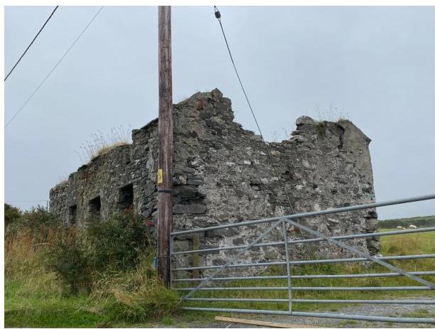
A photograph showing the dilapidated stone ruins of a traditional tholtan cottage with crumbling walls and no roof, viewed from behind a metal gate.
1.3 The structure which occupies part of the site is the remains of a cottage: almost all of the four walls still stand although the top parts of both gables are missing. The building has a footprint of 9m by 5.4 and the height of the walls is between 2.6m and 3.1m. The current structure appears to have the lower part of first floor windows which are partly within the lower part of the front roof plane - ie they would have been serving rooms partly within the roof space.
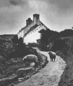
1.4 Historical images of the property provided by Manx National Heritage in the previous application appear to show the building limewashed and with an elevated eaves level at the front as is evidenced by the existing apertures on the first floor on the front of the existing building, only part of which still exist and with shallow dormer heads:
2.0 THE PROPOSAL
2.1 Proposed is the renovation of the building to form a dwelling including the creation of a residential curtilage which is bounded by a new sod hedge formed with material taken from the levelling of the site, a hedge which is 1.5m high with holly, hawthorn, fuchsia, honeysuckle planted within it.
2.2 The amount of rebuilding will be eaves level and above although lower than the existing wall tops, with a new slated roof constructed on the existing walls and the gables built up on both sides. The existing door and window apertures will be retained and doors and windows installed within them.
2.3 An extension is proposed to the rear: this will project 5.3m from the rear wall, just slightly shorter than the existing gable width, and will be 7m long - again, slightly shorter
A black and white photograph depicting a stone building on a hillside with sheep grazing on a path in the foreground.
than the overall length of the existing cottage. All elevations are to be finished in stone to match the existing and the roof finished in slate with the original stacks reinstated.
2.4 Car parking is proposed at the rear in a modest format which will accommodate up to three vehicles (exceeding the requirement of the Strategic Plan for two spaces) whilst still retaining the majority of the rear garden for amenity space and arranged so that vehicles can turn before leaving the site and can access the public highway in a forward gear. A shed is indicated as being provided in the rear garden for the secure storage of bicycles (capable of being erected without permission under the the Town and Country Planning (Permitted Development) Order 2012),
2.5 Visibility splays of 2.4m by 90m to the north and 2.4m by 53.7m to the south, created by relocating the existing electricity pole, clearance of vegetation within the splay and provision of a simple grass verge in front of the cottage and relocation of the gated entrance further back, are shown on drawing 2.
2.6 The application includes an updated Structural Engineer’s Report by Curtins, dated 14th October, 2021 which describes the building having a slight inward lean on the south facing wall, the rear wall exhibiting slight irregularity with loose rendering and a stepped vertical crack. They conclude that the existing wall structure of the cottage can be used for the proposed alteration and extension as now proposed with the rebuilding of the loose and cracked stone work on the front walls, the replacement of the existing slate lintels, the removal of vegetation from the wall structure, the infilling of loose open and voided stonework to the internal face of the external walls with new stonework fully bonded to the existing, the repointing of the external stonework and the setting of the floor and external ground levels to prevent undermining of the existing walls.
2.7 In their opinion the existing structure can accommodate the proposed conversion works and the amount of rebuilding is shown on the proposed elevations.
2.8 The application also includes traffic survey results which indicate that in 2011 of the 463 vehicles travelling southbound, the 85th percentile speed was 21 mph and for the 437 travelling northwards the 85th percentile speed was 24 mph. Whilst of some age, we do not believe that the traffic conditions have changed significantly since then and these figures may still be relied upon.
2.9 Renewable energy facilities are included in the form of an Air Source Heat Pump location (the actual pump could be installed without planning approval once the dwelling is completed and inhabited, under Class 23A of the the Town and Country Planning (Permitted Development and Change of Use) (Amendment) Order 2020). An electric vehicle charging point is also to be available.
3.0 PLANNING HISTORY
3.1 A previous application for the renovation of this property was refused (19/00448/B). This proposal had a larger curtilage and proposed to build up the existing structure to form a full two storey property. This was refused for four reasons:
1. Although an argument could be made that the existing building is of sufficient interest to warrant its retention and conversion, the extent of the structural works required to make the structure sound coupled with the unacceptable upwards extension, the overbearing rear extensions, the inappropriate modifications to the apertures and spread of hard standing and domestic curtilage would have a significant and adverse impact on the original appearance, character, historic interest and materials of the original building contrary to General Policy 3 (b) and Housing Policy 11.
2. There is no information to demonstrate that potable water can be provided for the site contrary to Housing Policy 13 (c).
3. The proposed alterations and extensions and the subsequent introduction of large areas of hard standing would result in an unacceptable visual impact on the wider rural landscape and countryside setting of the site contrary to Environment Policy 1 and paragraphs 8.10.1 and 8.10.2
4. There is insufficient information available to understand the impact of the development on the adjacent watercourse contrary to Environment Policy 7.
3.2 In this new application, the depth of the plot has been reduced to around 25m from 28m and the width from 18m to 15m. In addition, information has been provided relating to available visibility splays and land ownership. The dwelling is now single storey rather than building up to provide a full first floor of accommodation. Whilst the original house did have some upper level accommodation and a set of first floor windows, it was considered that to try and replicate this rather unusual format would result in something that did not look like something one may usually find in the Manx countryside and certainly would not comply with the advice available in Planning Circular 3/91.
3.3 The position of the existing watercourse has been shown on the drawings and is described as a small stream which runs along the side of the Balnahowe Road generally in an open ditch although as it passes the application site, it is culverted which is more than
4.5m from the front of the nearest part of the existing building. Precautions will be taken to ensure that there is no contamination of the watercourse nor its collapse. The introduction of hedging around the new residential curtilage will assist the alleviation of any flood risk from surface water coming down the fields as indicated in the flood risk maps.
3.4 The applicant has contacted Manx Utilities and it has been confirmed that it would be possible to take a water feed off the supply to Ballaman mains water supply.
4.0 PLANNING POLICY
4.1 The site lies within an area designated on the Area Plan for the South adopted in 2013 as not for a particular purpose. As such, there is a presumption against development here as set out in General Policy 3 and where the countryside is protected for its own sake as set out in Environment Policies 1 and 2 (the site lies within an area of an area of High Landscape or Coastal Value and Scenic Significance on the Isle of Man Planning Scheme (Development Plan) Order 1982 where the site also falls within a large area of ecological interest) and where the protection of the landscape character is the most important consideration.
4.2 General Policy 3 includes reference to other policies within the Strategic Plan which allow for the creation of new dwellings in undesignated areas where this reuses existing fabric considered of historical, architectural or social interest and subject to other criteria. Housing Policy 13 is the relevant policy and states the following:
Housing Policy 13: In the case of those rural dwellings which have lost their former residential use by abandonment, consideration will be given in the following circumstances to the formation of a dwelling by use of the remaining fabric and the addition of new fabric to replace that which has been lost. Where:
a) the building is substantially intact; this will involve there being at least three of the walls, standing up to eaves level and structurally capable of being retained; and
b) there is an existing, usable track from the highway; and where
c) a supply of fresh potable water and of electricity can be made available from existing services within the highway.
This policy will not apply in National Heritage Areas (see Environment Policy 6). Permission will not be given for the use of buildings more ruinous than those in (a) above, or for the erection of replacement buildings.
Extensions of dwellings formed in accordance with the above may be permitted if the extension is clearly subordinate to the original building (i.e. in terms of floor space(3) measured externally, the extension measures less than 50% of that of the original).
(1) Habitable Status is defined in Appendix 1 (2) Non residential use is defined in Appendix 1.
4.3 Generally, and specifically expressed in General Policy 2 and Transport Policy 4 new development must not adversely affect highway safety and parking standards as set out in Transport Policy 7 and Appendix 7 for single dwellings is two spaces within the site.
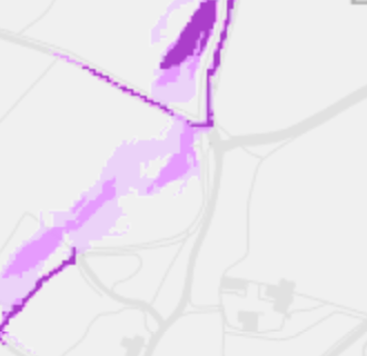
4.4 The footprint of the building does not lie within any area of flood risk although there is an area at risk of surface water flooding to the rear as shown on the national flood risk mapping shown below:
4.5 There are no Registered trees nor Registered Buildings on the site which does not lie within any Conservation Area - proposed or adopted.
4.6 Development which would be at risk of flooding is presumed against in Environment Policies 10 and 13.
National Flood Risk Mapping
4.7 Development is generally now requiring development to address the increasing Climate Change crisis and also aim to result in biodiversity net gain (Residential Design Guidance) as well as not adversely affecting ecology (Environment Policies 4 and 7).
5.0 Assessment
5.1 The previous refusal did not reject the principle of the renovation of the existing building to form a new dwelling and the causes of concern in that case - the scale and appearance of the extensions, the lack of information on the effect of the development on the adjacent water course, potable water and the effect of the proposed hard standing and curtilage - we believe have been addressed in this application which has reduced the size of the curtilage, and the extension and information has been provided to demonstrate how the proposal will try and address climate change and will enhance the biodiversity value of the site.
5.2 The existing building is considered to be “substantially intact” in accordance with HP13, as it has all four walls standing close to eaves level although not all of the two gables are still in existence. What formerly existed was an unusual building and we believe trying to reinstate the upper section of the front elevation with dormers as it had originally, would be unsuccessful and would afford little in the way of usable space internally. Such a project would lack the patina of age of the original and in our view, would not be the right approach here and we would favour of an approach which follows the more common design elements as found and advocated in Planning Circular 3/91.
The image displays a schematic map or site plan featuring faint grey road lines and prominent purple highlighted zones, likely indicating the site boundary or proposed development area.
5.3 The proposed introduction of new Manx hedging and native plants will enhance the value of the site for ecology and the applicant has no issue with a condition which requires surveys for bats and lizards prior to any works commencing.
5.4 The applicant also has no issue with preparing a photographic record of the existing building on the site, as suggested by Manx National Heritage in the previous application.
5.5 Subject to the above, we believe the proposal should be supported.
Sarah Corlett 08.11.21
Copyright in submitted documents remains with their authors. Request removal
Source & Provenance
Official reference
21/01341/B
Source authority
Isle of Man Government Planning & Building Control