Loading document...
The Alignment of two existing farm accesses off the A26 and creation of track way to Ballavarvane Farm, Braaid Road, St. Marks Isle of Man
October 2021 Prepared by: Ellis Brown, Architects 12 Strathallan Crescent, Queen’s Promenade, Douglas IM2 4NR
The Alignment of two existing farm accesses off the A26 and creation of track way to Ballavarvane Farm, Braaid Road, St. Marks Isle of Man
Ballavarvane Farm is on the outskirts of St Mark’s village. The farm is roughly rectangular but is bisected diagonally by the A26. The farm consists of approximately 185 acres, of which around 110 acres together with all the farm buildings and dwellings are on the northwest side of the road and 75 acres on the south-eastern side. The south-eastern part of the farm fronts the A26 continuously for about 850 metres and the north-western part for about a little less, the difference being made up by the road frontage of the property known as the Old Mill which is in third party ownership unconnected with the farm.
The Current Main Entrance Whilst there are several field entrances onto the A26 dating from much ‘slower’ times, the Current Main Entrance to both parts of the farm and the route between them for all purposes, including particularly agricultural plant and livestock, consists of two directly opposing entrances in a cross-road configuration on the A26 approximately 650 metres north-east of St Mark’s cross-roads.
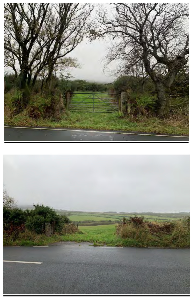
The entrance at this point to the north-western part of the farm, whilst in the same ownership as the farm, also serves the Old Mill which is immediately on the left when entering. This entrance is flanked (along the road frontage) by, on the left, a Manx stone wall (in front of the Old Mill) approximately 1.3m in height and set back less than 1m from the road edge, and, on the right, by a low stone wall formation partly embedded into a low sod bank with a tree line on top and a culvert beneath. It then leads, via a narrow, gravelled farm track lined with a variety of trees and shrubs, to the main farmyard and dwellings. The opposing entrance, to the south-eastern part of the farm, is tree lined on both sides and opens directly into an agricultural yard serving that part of the farm and is subject to covenants allowing the MUA access for workers and plant to service main arterial services running under that part of the farm.
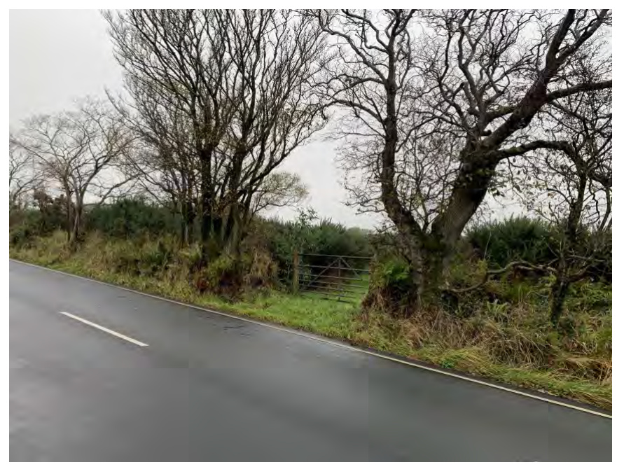
Visibility along the main A26 road is poor from both entrances. From the entrance to the farm track it is currently 18m to the south-west and 43m to the north-east; and, from the agricultural yard opposite, 11m and 19m respectively. The A26 in this location is subject to a 50mph speed limit. Both sets of sightlines are considerably below the Highway Department’s requirement of 120m unobstructed visibility in both directions for a 50mph limit road and they have stated (in relation PA 20/01215/B [the June 2021 Approval] see later) that they “would not be flexible over the visibility splays” as “this is a rural road with relatively high speeds often above the speed limit of 50mph and overtaking” with ”no scope to mitigate where there are slow moving vehicles perhaps towing and it is a cycle route” (email from Sheila Henley 26/2/2021).
Since the acquisition of the farm in 2016 the occupants have had first-hand experience of the hazardous nature of the current access arrangement including involvement in a collision whilst crossing between the two halves of the farm in September 2019 resulting in damage to two vehicles, in one case very severe (understood to have been written off).
Previous occupants of the farm also recall “several accidents one of which resulted in the death of several heifers and a farm dog”. In addition, the current occupiers and others involved with the farm have experienced several ‘near misses’ and raised concerns as to the current arrangement, welcoming the proposal for improvements. Information from the Isle of
The Alignment of two existing farm accesses off the A26 and creation of track way to Ballavarvane Farm, Braaid Road, St. Marks Isle of Man
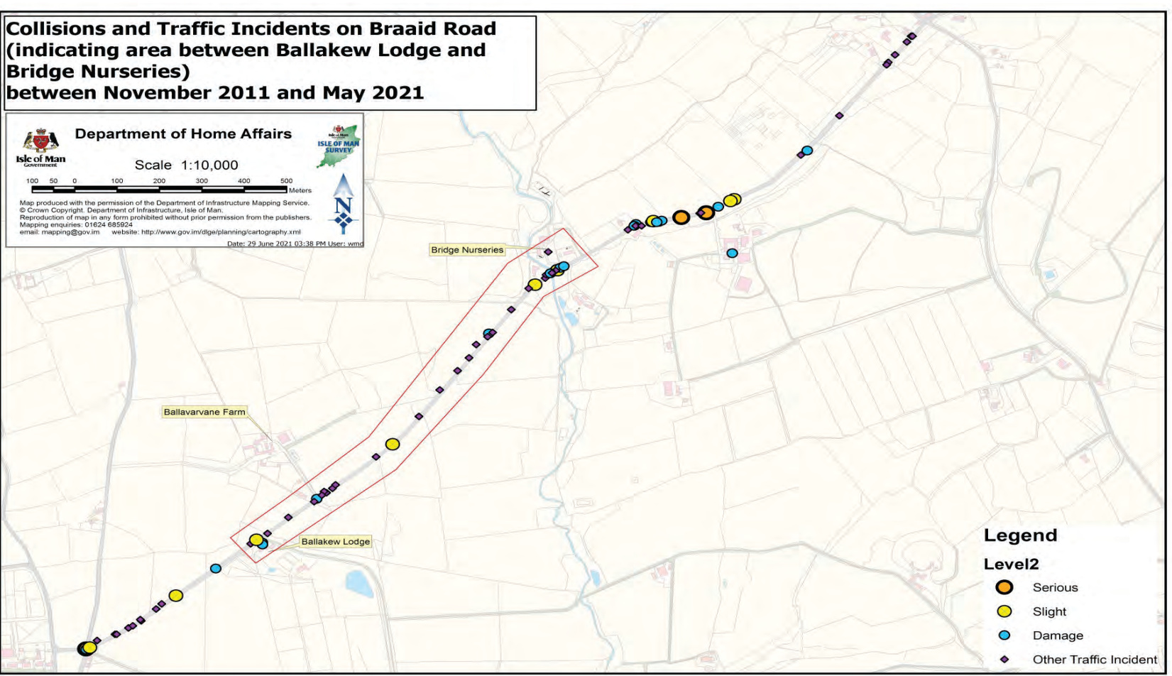
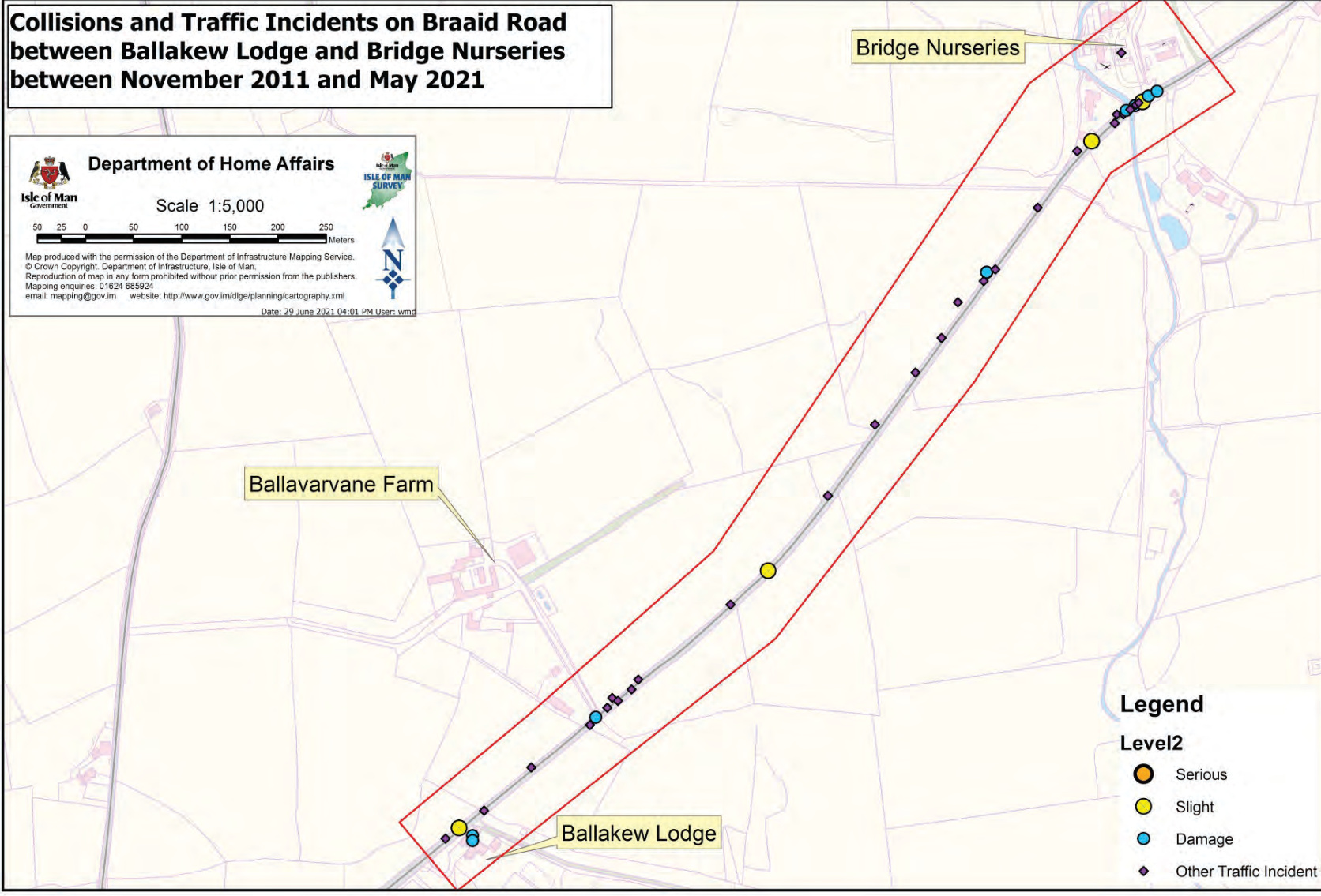
Man Constabulary indicates a group of incidents at the same location between November 2011 and May 2021. (See appendix A)
Further traffic / incident information is contained in the Road Safety Audit undertaken as required by the Department of Infrastructure Highways division.
These concerns are so serious that the creation of a safer access/egress between the two parts of the farm is the applicant’s prime consideration in relation to the farm at the present time, and the issues only seem to be getting worse. Recently there has been a noticeable increase in the traffic using this road, particularly at peak times. This may be attributable to the road works at Ballasalla and Richmond hill, but it should also be noted that the IoM Business Park and the similar commercial expansion on the South side of Cooil Road (Riley’s / Eden Park / Jacksons), has led to an increase in traffic generally. It is understood that there are also proposals for further development in the Cooil area which would be likely to further increase traffic levels along the A26.
The principal purpose of this application is to obtain opposing safe entrances to both sides of the farm offering a safe route between them enabling farming operations to take place safely and for the safety of the occupants. If successful, this new proposal is intended to replace and supersede the previous proposal of October 2020, which was approved by the Planning authority in June 2021 (PA 20/01215/B) (The June 2021 Approval) which achieved all these objectives but attracted significant media attention and concerns due to the potential impact on the ‘Elm Tunnel’ along that part of the A26. This application is in response to those concerns and seeks to obtain the same result without affecting the Elm Tunnel.
The following photographs of the Current Main Entrance show in order the entrances to the north-west and south-east parts of the farm.
The June 2021 Approval offered fully compliant accesses and sightlines in the immediate vicinity of the Current Main Entrance incorporating the current entrance within those sightlines to minimise the felling of trees forming part of the Elm Tunnel. The new proposal is
The Alignment of two existing farm accesses off the A26 and creation of track way to Ballavarvane Farm, Braaid Road, St. Marks Isle of Man
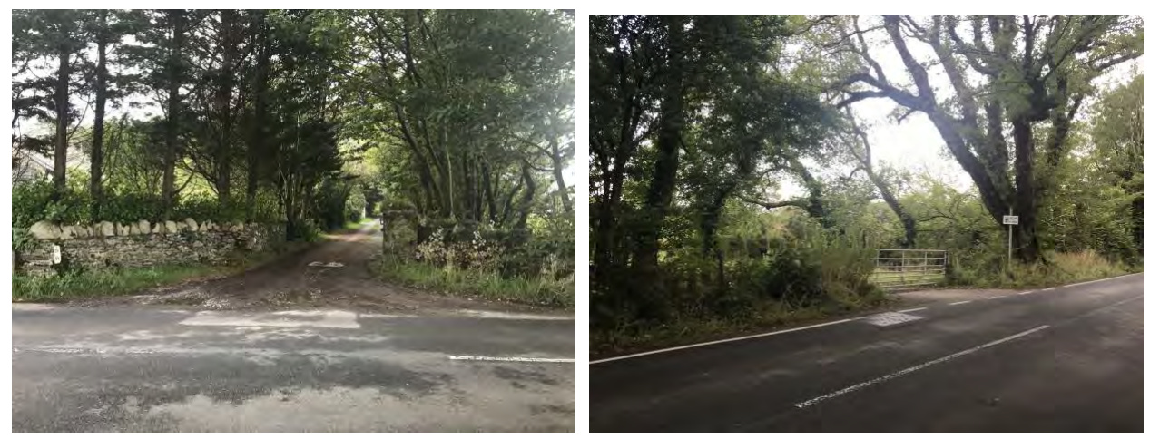
instead to improve a pair of existing entrances approximately 400m to the north-east beyond the end of the Elm-Tunnel. The opening onto the north-western part of the farm at this point is already connected by an existing track to the farmyard and dwellings. However, the corresponding agricultural access to the south-eastern part of the farm will need to be moved a few metres to the south-west to obtain the correct cross-road geometry mirroring the sightlines and geometry provided by the June 2021 Approval, with the resultant gap being infilled to match the adjoining bank/hedge.
Existing access point on the NW side of the A26 to be adjusted
Existing access point on the SE side of the A26 – to be relocated, proposed to be opposite the access on the NW side
The Alignment of two existing farm accesses off the A26 and creation of track way to Ballavarvane Farm, Braaid Road, St. Marks Isle of Man
To avoid vehicles obstructing the highway when entering, the proposed gated accesses on both sides of the road, are intended to be set back 8.5m from the highway. As part of this arrangement it is also proposed to create visibility splays by re-aligning the current low-level banking in both directions, incorporating some low-level planting and grassed areas maintained to a height below 1.05m for visibility (proposed vegetation is to be agreed with the landscaping specialist). This arrangement should create an openly visible access/egress for vehicles of all sizes.
The existing entrance on the north-western side of the road which it is intended to be improved is adjacent to an existing drainage ditch which is to be protected and maintained during the works and retained at completion. As already stated, this entrance leads to an existing track to the farmyard and dwellings which route the new access is intended to follow save for a rearrangement of the geometry immediately within the entrance to allow for the turning of large farm vehicles and trailers. However, the existing track runs between established banks and hedges and, because of its length, would require the creation of passing places. When a site visit was carried out by various parties including the DEFA Ecology Officer, it was felt that it would be better to leave the existing track much as it is enabling it to act as a “wildlife corridor” and run the improved track alongside it but just outside the bank/hedge. This application incorporates this suggestion and includes additional tree and hedge planting along its southern side.
The new access road is to join the existing track at the farm entrance area as indicated on drawing - 19/3003/10 – Proposed Site Plan’.
Details of the trees and shrubs that need to be removed to provide for sightlines adjacent to the improved access points are included on drawing – ‘19/3003/11 – Proposed Site and Entrance Plan’ and further tree survey information drawings, documents/reports and mitigation proposals provided by Manx Roots, tree management specialists, are also provided, and include details of planting of native and suitable species adjacent to the improved track as it travels toward the farm buildings.
Pre-Application consultations have been held both on and off site to encourage stakeholder engagement. These consultations have included: -
The above parties met at the site (Mr John Ward on a separate occasion) and walked the area where the proposal is located. The existing ground / landscape / ecological features were reviewed.
Additional consultations.
The Alignment of two existing farm accesses off the A26 and creation of track way to Ballavarvane Farm, Braaid Road, St. Marks Isle of Man
to make comment at this stage and we take a neutral stance in respect of the proposed alternative entrance.”
The pre application consultations have been encouraging in that advice and guidance where received has informed the proposals, resulting in the proposal as submitted.
Lining proposals whilst not fully designed are to be included of a type and style that would be appropriate to the location. These details are to be agreed with the highways authority and could include for example solid white lining that would indicate a restriction to overtaking in the area, should it be deemed required.
Signage proposals are indicated on the proposal drawings and includes signage advising highway users of the amended access points formed, this will include shorter term signage to advise of new arrangement.
A Stage 1 Road Safety Audit has been commissioned and when received will be submitted as supplementary information. The applicant is agreeable that full details of these to be subject to a condition for final design and installation.
The proposed visibility from both junctions have been designed that a view of 120m can be seen in both directions at a set-back of 2.4m from the roadway with no obstruction over 1.05m in height. The set back of 2.4m has been taken from a position of 0.5m into the roadway as deemed acceptable from the Highways Department with a view that would better reflect a vehicle driving position on a road of this nature.
A vehicle tracking drawing has been provided for this development using the recommended vehicle of a refuse collection vehicle as discussed and advised by the Department of Infrastructures Highways division.
Supporting Statement (this document) EB Drawings:- 19/3003/10 Site and Location Plans
The Alignment of two existing farm accesses off the A26 and creation of track way to Ballavarvane Farm, Braaid Road, St. Marks Isle of Man
Client Developer guidance document CDG 2021 BS Ballavarvane AIA 251021 TS – 230921 – Tree Constraints Plan TR – 251021 – Tree Impact Plan Balavarvane MP 251021 – Planting proposal report MP – 2515121 Tree Planting plan
Proposed Alterations to Pair of Existing Entrances at Ballavarvane Farm, St Marks, Isle of Man
I farmed Ballavarvane Farm between 1965 and 2015. The speed of traffic on the Braaid to St Marks Road was always an issue when trying to get from one side of the farm to the other especially when cars tried to overtake.
I vividly remember several accidents especially one which resulted in the death of several heifers and a farm dog.
I am glad I no longer have the daily worry of trying to get across the road with agricultural machinery or on foot when having to check livestock.
The problem with cars speeding has been an issue for decades but over time it appears that things have become worse.
Yours faithfully
G W Kinvig
Dear Sir or Madam
We are the main agriculture contractors for Ballavarvane Farm and consequently have to travel along and across the A26 road on a regular basis as the farm has fields on both sides of the road.
With traffic travelling at speed and often overtaking, trying to get into or out of one of the fields or the existing farm lane is honestly quite terrifying especially with a tractor and trailer or other slow moving agricultural machinery.
Having to get out of the tractor to open a gate into any of the fields adjacent to the A26 is even more of a concern so consequently we often have to leave the gates open to reduce the risk of getting run over.
Yours faithfully
Ashley Kinvig
11 Victoria Road Castletown Isle of Man IM9 1EN
Web www.manxwildbirdaid.com Email [email protected] Telephone 07624 242777 30/06/2021
Dear John,
I am happy to put on record our involvement with Ballavarvane farm and the problems we and our volunteers have experienced entering and leaving the driveway:
A couple of years ago we found ourselves with an increasing number of young and injured birds which we needed to re-homed. Therefore we were very grateful when you offered to allow us to erect aviaries at the farm. We now have 5 aviaries there, housing around 60 birds. Some of these birds may be able to be released when they are fully healed, and the farm provides a safe environment for their release. However, many are permanently disabled and the aviaries provide them with a safe and secure environment for the rest of their lives.
The birds obviously need care, which entails personal visits once or twice a day. Visits are made by either ourselves or our volunteers, resulting in several entries and exits to Ballavarvane. Although there is a 50 mph speed limit, the long straight road past the farm, with no obvious side roads, seems to entice drivers to vastly exceed this limit, often seeming to be travelling well in excess of 80 mph. Exiting the property is very scary. When leaving the driveway, the field of vision on the right is severely restricted by the neighbours' stone wall/hedge, and by the trees abutting the drive on the left. In order to see oncoming traffic a dangerous manoeuvre has to be made. Sticking the bonnet out into the road, hoping you are seen by other drivers before being able to see what is coming. Due to the speed of the vehicles there is little time to react. Exiting in either direction is dangerous.
We and many of our volunteers have had near misses and I have personally witnessed an accident when several free range chickens were killed at this junction just in front of me. Sadly all the chickens at the farm, including some we had rescued, now have to be enclosed. The driver did not stop and didn't seem to care at all. We also understand that recently the neighbours' dog was killed at the same spot having been dragged some distance.
When new volunteers go to the farm, we make it a point to warn them of the danger. The situation is really dangerous and we do hope that we can all soon benefit from a safer exit.
Best regards
Redacted
Barbara Cole
Registered Office: 11 Victoria Road, Castletown, Isle of Man. IM9 1EN Charity No. 1228 Trustees: David Cole, Fern Fraser, Elaine Wilson, Jane McCann and Laura Bruder
The area reviewed was for events mapped in a rectangle between X grid references 229620 and 231605, Y grid references 474150 and
The focus area of the road, between Ballakew Lodge and Bridge Nurseries (named the Ballavarvane section in this report), was used to select key incidents. Note, in maps provided, some traffic incidents on Braaid Road were mapped to premises they occurred outside, rather than exact location on road.
| Key Area | Level | 20 12 | 20 13 | 20 14 | 20 15 | 20 16 | 20 17 | 20 18 | 20 19 | 20 20 | 20<br>21<br> | Total |
|---|---|---|---|---|---|---|---|---|---|---|---|---|
| Ballavarvane section | Slight | 1 | 1 | 1 | ||||||||
| Ballavarvane section | Damage | 2 | 1 | 2 | 1 | 1 | ||||||
| Ballavarvane section | Other Traffic Incident | 2 | 5 | 4 | 3 | 2 | 5 | 3 | 3 | 2 | 1 | |
| Ballavarvane section Total | Ballavarvane section Total | 2 | 7 | 6 | 6 | 3 | 5 | 4 | 4 | 2 | 1 | |
| Other Braaid Road | Serious | 1 | 2 | |||||||||
| Other Braaid Road | Slight | 1 | 1 | 1 | 2 | |||||||
| Other Braaid Road | Damage | 1 | 2 | 2 | 3 | 2 | 2 | 1 | ||||
| Other Braaid Road | Other Traffic Incident | 4 | 2 | 2 | 4 | 6 | 3 | 2 | 1 | |||
| Other Braaid Road Total | Other Braaid Road Total | 6 | 4 | 2 | 5 | 9 | 8 | 3 | 6 | 2 | ||
| Grand Total | Grand Total | 8 | 11 | 8 | 11 | 12 | 13 | 7 | 10 | 4 | 1 |
For the Ballavarvane Section: Some causes note NFD, which indicates no further details available. In only a couple of incidents was it possible to determine extra detail on causes.
| Key Area | Level | 2012 | 2013 | 2014 | 2015 | 2016 | 2017 | 2018 | 2019 | 2020 | 2021 | Total |
|---|---|---|---|---|---|---|---|---|---|---|---|---|
| Ballavarvane section | Slight | 1 | 1 | 1 | 3 | |||||||
| Damage | 2 | 1 | 2 | 1 | 1 | 7 | ||||||
| Other Traffic Incident | 2 | 5 | 4 | 3 | 2 | 5 | 3 | 3 | 2 | 1 | 31 | |
| Ballavarvane section Total | 2 | 7 | 6 | 6 | 3 | 5 | 4 | 4 | 2 | 1 | 40 | |
| Other Braaid Road | Serious | 1 | 2 | 3 | ||||||||
| Slight | 1 | 1 | 1 | 2 | 5 | |||||||
| Damage | 1 | 2 | 2 | 3 | 2 | 2 | 1 | 13 | ||||
| Other Traffic Incident | 4 | 2 | 2 | 4 | 6 | 3 | 2 | 1 | 24 | |||
| Other Braaid Road Total | 6 | 4 | 2 | 5 | 9 | 8 | 3 | 6 | 2 | 45 | ||
| Grand Total | 8 | 11 | 8 | 11 | 12 | 13 | 7 | 10 | 4 | 1 | 85 |
| Level | Cause | 2012 | 201 3 | 201 4 | 2015 | 2016 | 2017 | 2018 | 2019 | 2020 | 202 1 | |
|---|---|---|---|---|---|---|---|---|---|---|---|---|
| Slight | Misjudging clearance, distance or speed | 1 | ||||||||||
| Slight | Losing control | 1 | ||||||||||
| Slight | Losing control (dazzled by sunshine after shade under trees) | 1 | ||||||||||
| Damage | Excessive speed having regard to conditions | 1 | ||||||||||
| Damage | Inattentive or attention diverted | 1 | ||||||||||
| Damage | Misjudging clearance, distance or speed | 1 | 1 | |||||||||
| Damage | Driving w/o Due Care & Attention | 1 | ||||||||||
| Damage | Driving w/o Due Care & Attention (Entering major road without due care) | 1 | ||||||||||
| Damage | RTC - Damage Only NFD | 1 | ||||||||||
| Other Traffic Incident | Misjudging clearance, distance or speed | 1 | ||||||||||
| Other Traffic Incident | Breakdown | |||||||||||
| Other Traffic Incident | Ice, frost or snow on road surface | 1 | ||||||||||
| Other Traffic Incident | Dangerous Driving | 1 | 1 | |||||||||
| Other Traffic Incident | Driving w/o Due Care & Attention | 2 | 1 | 1 | 1 | |||||||
| Other Traffic Incident | Obstruction | 3 | 1 | 1 | 2 | 1 | ||||||
| Other Traffic Incident | Speeding Complaint | 2 | ||||||||||
| Other Traffic Incident | Stray Animals | 2 | 1 | 1 | 1 | |||||||
| Other Traffic Incident | Inadequate speed complaint | 1 | ||||||||||
| Other Traffic Incident | Other Traffic Incident NFD | 1 | 3 | |||||||||
| Grand Total | 2 | 7 | 6 | 6 | 3 | 5 | 4 | 4 | 2 |
| Level | Cause | 2012 | 2013 | 2014 | 2015 | 2016 | 2017 | 2018 | 2019 | 2020 | 2021 | Total |
|---|---|---|---|---|---|---|---|---|---|---|---|---|
| Slight | Misjudging clearance, distance or speed | 1 | 1 | |||||||||
| Losing control | 1 | 1 | ||||||||||
| Losing control (dazzled by sunshine after shade under trees) | 1 | 1 | ||||||||||
| Damage | Excessive speed having regard to conditions | 1 | 1 | |||||||||
| Inattentive or attention diverted | 1 | 1 | ||||||||||
| Misjudging clearance, distance or speed | 1 | 1 | 2 | |||||||||
| Driving w/o Due Care & Attention | 1 | 1 | ||||||||||
| Driving w/o Due Care & Attention (Entering major road without due care) | 1 | 1 | ||||||||||
| RTC - Damage Only NFD | 1 | 1 | ||||||||||
| Other Traffic Incident | Misjudging clearance, distance or speed | 1 | 1 | |||||||||
| Breakdown | 1 | 1 | ||||||||||
| Ice, frost or snow on road surface | 1 | 1 | ||||||||||
| Dangerous Driving | 1 | 1 | 2 | |||||||||
| Driving w/o Due Care & Attention | 2 | 1 | 1 | 1 | 5 | |||||||
| Obstruction | 3 | 1 | 1 | 2 | 1 | 8 | ||||||
| Speeding Complaint | 2 | 2 | ||||||||||
| Stray Animals | 2 | 1 | 1 | 1 | 5 | |||||||
| Inadequate speed complaint | 1 | 1 | ||||||||||
| Other Traffic Incident NFD | 1 | 3 | 4 | |||||||||
| Grand Total | 2 | 7 | 6 | 6 | 3 | 5 | 4 | 4 | 2 | 1 | 40 |
Copyright in submitted documents remains with their authors. Request removal