Loading document...
The purpose of this planning application is to seek planning permission for the erection of a new detached dwelling with integral garage accommodation on a site to the rear of existing stables and storage buildings on Glen Auldyn Road, Lezayre. The scheme would involve removal of an existing horse lunging ring at the rear of the site to form an open area where the proposed new dwelling would be constructed. As part of the proposal, the end lean-to bay of the existing agricultural building abutting the site would be taken down and removed to leave the original pitched roof, agricultural storage building in place. The current agricultural building has a blockwork wall at lower level on the south side with corrugated sheet cladding on the upper level to the underside of the lean-to roof. The east (rear) and north sides of the lean-to extension are open sided and all cladding, roof sheeting and steelwork would be removed.
As part of the proposal, four trees, two adjacent to the lunging ring and two self-seeded trees growing in the rear wall of the agricultural building, would also be removed and these have been indicated on the accompanying Site Plan.
The site for the proposed dwelling is set beyond an existing agricultural storage building with a pitched, corrugated sheet roof and this agricultural building is situated behind a part two storey, part single storey, traditionally constructed Manx stonework and brick built stable and storage building block which has pitched, natural slate finished roof areas. The area to be utilised for the proposed dwelling is a disused lunging ring, a circular open space bounded by solid timber "walls". The site is set between two properties, "Shandrum" to the north and "Hazelmere" to the south. The boundary to "Shandrum" is well protected with hedging and trees forming a dense foliage boundary above a blockwork wall between the proposed site and existing dwelling at "Shandrum". The boundary between the site and "Hazelmere" is bounded by a traditional sod hedge with a number of existing trees sparsely situated along the hedgerow. The agricultural building is currently used for hay storage only and this is utilised for bedding and feeding for the adjacent stables.
Photographs indicating the existing lunging ring where the proposed new dwelling would be situated are enclosed at APPENDIX 1. These photographs also show the existing agricultural building with the lean-to section proposed for removal as well as the locations of the four trees to be removed. The photographs also show the neighbouring property at "Hazelmere" as well as the substantial boundary hedge set between the proposed site and "Shandrum" to the north.
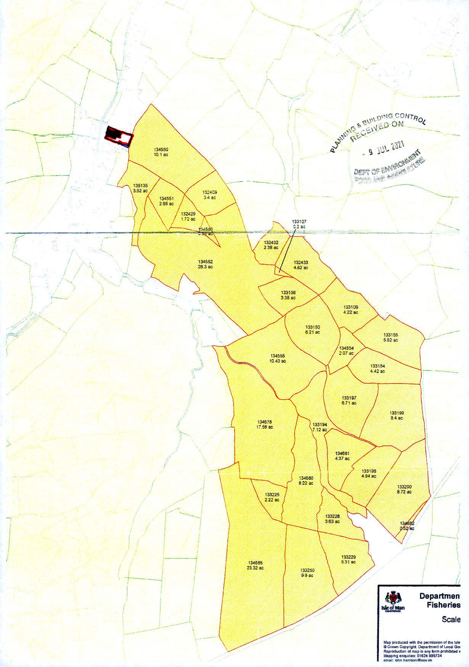
The site is contained within a predominantly residential area although the stables and agricultural building have a current agricultural use in this location. Besides the existing buildings and site for proposed new dwelling, the Applicant also owns a further 203 acres of land in the immediate vicinity extending up through the Glen behind the proposed site to the Mountain Road. This land is mainly agricultural on the upper reaches and wooded on the lower slopes. Access to this land is via the existing vehicular access leading from Glen Auldyn Road into the site. The upper reaches of farmland are managed by the Applicants family. The lower area of land adjacent to the existing buildings where the proposed new dwelling would be situated is zoned as Low Density Housing In Parkland as identified on the 1982 Isle of Man Development Plan.
A photocopy section of the 1982 Development Plan is enclosed at APPENDIX 2.
A photocopy Plan indicating the extent of lands in the ownership of the Applicant is enclosed at APPENDIX 3.
Access to the site is via an existing roadside opening forming a vehicular access to the existing stables and storage buildings, the existing agricultural building to the rear of the stables and storage buildings and the track used by Manx Utilities to gain vehicular access to the Ramsey Service Reservoir at the top of the hill behind the proposed site. The Ramsey Service Reservoir was originally served by a temporary road installation running through fields abutting Glen Auldyn Road but, upon completion of the Service Reservoir, the temporary access road was removed and a new permanent vehicular access reverted to the current vehicular access abutting the existing stables and agricultural building adjacent to the site for our proposed new dwelling. The existing vehicular access and track utilised by Manx Utilities are wholly owned by the Applicant.
A Location Plan indicating the relationship of the Ramsey Service Reservoir to the proposed site is attached at APPENDIX 4 with the site edged in red and the access track leading to the Ramsey Service Reservoir edged in blue.
The existing roadside access is formed by two original stone gate pillars with metal field gates abutting Glen Auldyn Road. To the north of the gate pillars is a continuous Manx stone wall which extends across the whole of the frontage of the site in the ownership of the Applicant. The vehicular access is contained within a 30 miles per hour speed limit area. There were, originally, 30 mile per hour warning signs painted on the carriageway but these have been removed as the road is currently having a new tarmacadam surface laid.
As part of the proposal, the Applicant would wish to retain the original stone gate pillars forming the entrance to the site but would be prepared to lower the original existing Manx stone wall fronting the site to a height of 1.000 metre to improve visibility to the north. The Manx stone wall is also original with white granite stones forming the "coping" along the Manx stone wall and the intention would be to remove the top courses of natural stonework to a flat level base and replace the original white granite stones on top of the lowered wall. By lowering the wall to a height of 1.000 metre, visibility would be improved for a 45.000 metre distance to the north up to a point where there is a large tree adjacent to the Glen Auldyn Road. The tree is on land in the ownership of the Applicant and is situated at the slight corner which then turns away from the site as it runs towards Glen Auldyn Bridge.
The existing stone boundary wall is generally 1.300 metres high and some 1.600 metres high to the top of the white granite stones.
Should the Network Planning Engineer of the Highways Division deem that the original gate pillars should also be reduced in height to afford improved visibility, the Applicant would be prepared to demolish the original feature and replace the gate pillars with much lower pillars to comply with the requirements of the Highways Division.
A number of photographs indicating the existing vehicular access to the site are attached at APPENDIX 5. These indicate the existing vehicular access to the site with stone gate pillars and stone boundary wall abutting Glen Auldyn Road. Also shown are part of the existing stable buildings with a gate leading to the access serving the proposed plot and this is the vehicular access used by Manx Utilities to gain access to the Ramsey Service Reservoir.
FLOOD RISK:
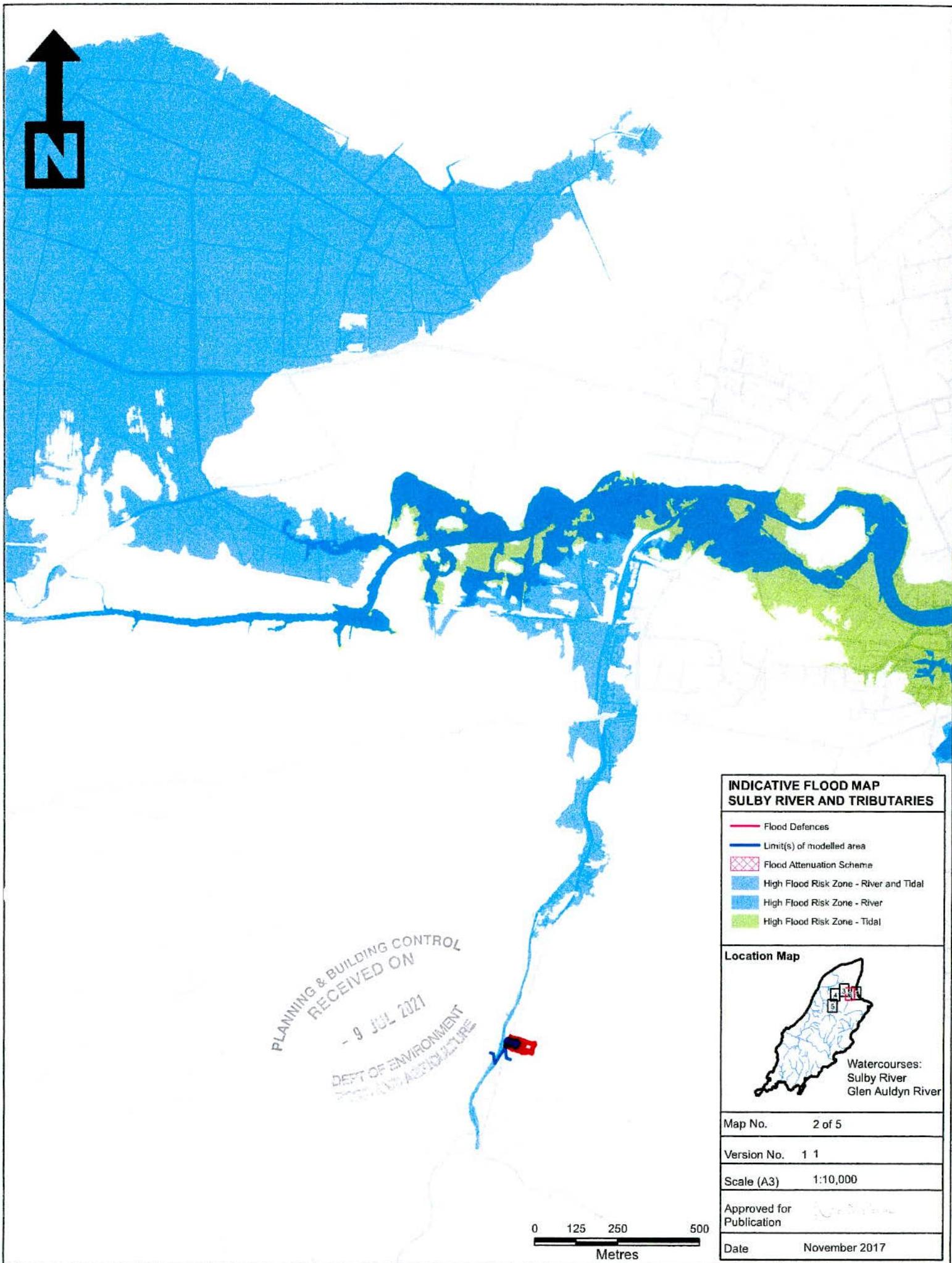
Although the Glen Auldyn River is in fairly close proximity to the site, it runs on the opposite side of the Glen Auldyn Road and the Indicative Flood Map for Sulby River and Tributaries show that the proposed site is not at risk from flooding. A copy of the Flood Map showing the proposed site in relation to Glen Auldyn River is enclosed at APPENDIX 6.
SERVICES:
The site is currently served by mains electricity and mains water. The existing stables and storage buildings to the front of the site have a foul drainage system currently connected into the main foul sewer running along Glen Auldyn Road. The proposed dwelling would be served by a new foul sewer running along a corridor of land in the Applicants ownership adjacent to the existing stables and agricultural building with a connection made into the existing foul sewer in Glen Auldyn Road. Surface water drainage would be by means of new soakaways set on the site.
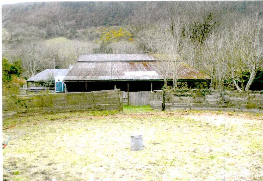
This photograph is taken from within the lunging ring and shows the neighbouring property at "Hazelmere" with approximate orientation of the proposed dwelling. The slate roof covering of existing stables towards the front of the site is visible on the right hand side of the photograph together with the start of the lean-to agricultural storage building (proposed for removal).
This photograph is taken from within the lunging ring and shows the remainder of the lean-to agricultural building proposed for removal, together with trees, also proposed for removal, and the existing boundary hedge between the proposed site and "Shandrum".
This photograph is taken at the entrance to the lunging ring showing substantial tree belt to the rear of the site.
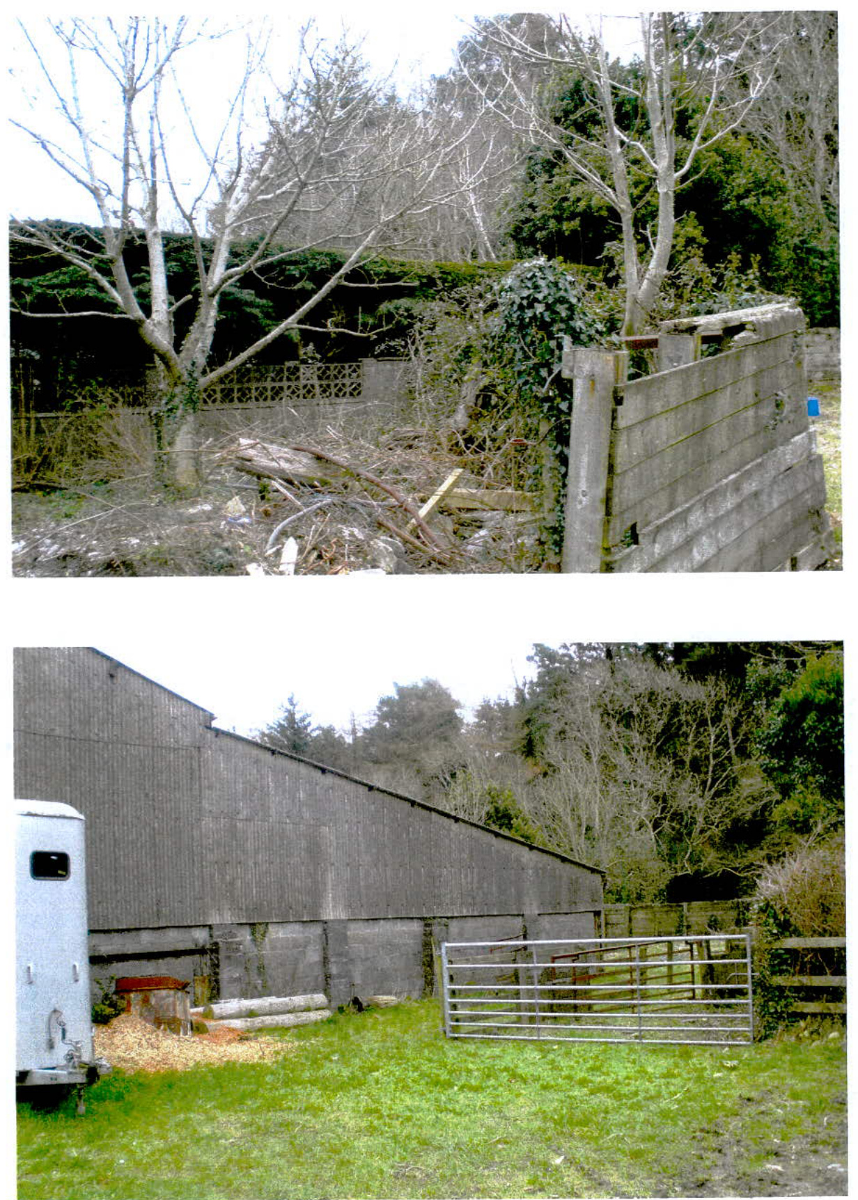
This photograph shows the existing lean-to section of the agricultural building together with existing trees abutting the lunging ring all proposed for removal.
Taken outside of the lunging ring but shows two of the trees proposed for removal together with the existing blockwork and screen block boundary wall and substantial hedging set between the proposed site and "Shandrum".
This photograph is taken on the vehicular access to the site and shows the gable end structure of the existing lean-to agricultural building proposed for removal.
This photograph is taken from between the existing stone gate pillars looking south towards the lower end of Glen Auldyn.
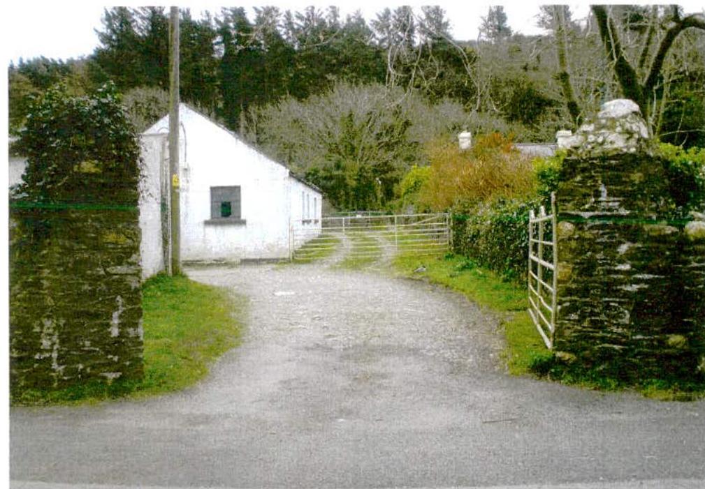
Taken from Glen Auldyn Road looking at the existing vehicular access into the site. This photograph also shows the existing stables and storage buildings behind the boundary wall abutting Glen Auldyn Road and the existing vehicular access into "Hazelmere".
Taken from between the existing entrance gate pillars looking north towards Glen Auldyn Bridge.
Looking from Glen Auldyn Road towards the existing vehicular access into the site with existing stables on the left hand side of the photograph. The vehicular access to the proposed site would continue through the gate to the right hand side of the stable buildings into the proposed site. This access is also used by Manx Utilities to gain vehicular access to the Ramsey Service Reservoir.
The preceding comments are to be taken into consideration along with submitted drawings for this proposed new dwelling with integral garage on land adjacent to the existing stables and agricultural building off Glen Auldyn Road, Lezayre.
{{image:7218325}} {{image:7218326}} {{image:7218327}}
DEPT OF ENVIRONMENT
AND ADDRESS
ASSOCIATE BUILDING CONTRACT RECEIVED ON 19 JUL 2011 DEPT OF PANDENAIRA 2010 AND MANAGEMENT
ISLE OF MAN PLANNING SCHEME (DEVELOPMENT PLAN) PROVISIONAL ORDER 1982 SCALE - 1 (SLED)
Map produced with the permission of the late Artiswan Copyright Department of Local Sta- deproduction of may in any form prohibited a dispiring response. 11/03/2021 24 email: [email protected]
{{image:112474}} {{image:7218472}} {{image:7218473}}
(legislature)
{{image:7218475}} {{image:7218476}} {{image:7218477}}
The Flood Map indicates the extent of river flooding associated with a flood event having a 1% chance of occurring in any year (1 in 100-year event) and the extent of coastal flooding for the extreme sea level having a 0.5% chance of occurring in any year (1 in 200-year event). In both cases the potential effects of climate change on flood magnitudes are accounted for (by assuming a 28% increase in peak river flood, and taking into consideration the predicted degree of sea level this based on a 2155 time horizon). The Flood Map indicates where formal flood distances and flood alleviation schemes are in place, and the mapped extents of flooding reflect the influence of flood distances on flood risk. However, defence structures may not completely remove the risk of flooding in extreme events. It should also be noted that distances can be breached or fall in extreme weather conditions, and coastal defences can be overlapped by large waves. These additional risk factors are not considered in the Flood Map. The information provided is not an at resolution appropriate for localized flood risk assessments and should not be assumed as definitive at the property scale. Individual properties may, therefore, not always be at the same risk of flooding as surrounding areas/proparities. If you believe that a particular property has a different risk of flooding to that shown on the Flood Map and/or if you have information you believe may not have taken into account when preparing the Flood Map please contact Maria Utilities. As and when additional relevant information becomes available to Maria Utilities, the Flood Map will be improved and updated. Maria Utilities reserve all intellectual property rights associated with the Flood Map. Maria Utilities believe that the Flood Map, and information contained therein, assume with the information currently available to it, but no representations or warranties (express or implied) are given with regard to its accuracy. To the fullest extent permitted by law Maria Utilities will not accept liability for any losses resulting in connection with the Flood Map. Unauthorized reproduction infringes copyright and may lead to prosecution or civil proceedings. Mapping is based upon the title of Main survey map with permission of the Department of Infrastructure, © Crown Copyright Department of Infrastructure, title of Man.
Copyright in submitted documents remains with their authors. Request removal