Planning Appeals Secretary, Department of Local Government and the Environment, Murray House, Mount Havelock, Douglas, Isle of Man.
4th September 2006.
Dear Sir,
Re: PA 06/00212: Development of land at “Far End”, King Edward Road, Onchan for Westgin Ltd.
Our company was originally approached by Westgin Ltd to inspect the application site which consisted of a dwelling known as “Far End” with a large rear garden, and a site of approx 2 acres to the north west. We were told that previous applications for developing this entire 3 acre site had consisted of a large number of apartments, and had been refused. Both our clients and ourselves considered that the site would be far better developed as dwellings and garages, to coincide with the Majestic Drive and Lag Birragh Drive developments, and thus would complete this overall development with similar dwelling types and density.
Our first look at the house “Far End” showed that the dwelling had been neglected for some years, with water ingress evident and all external timber work in a poor state. It was agreed that our proposals should include the demolition of “Far End” and a replacement dwelling repositioned to provide the access road to the site. The overall site has a gently slope towards the sea, is bordered by the public footpath on the south and south east, King Edward Road to the north east and three dwellings towards Lag Birragh Drive. There is tree screening to the three dwellings on Lag Birragh Drive.
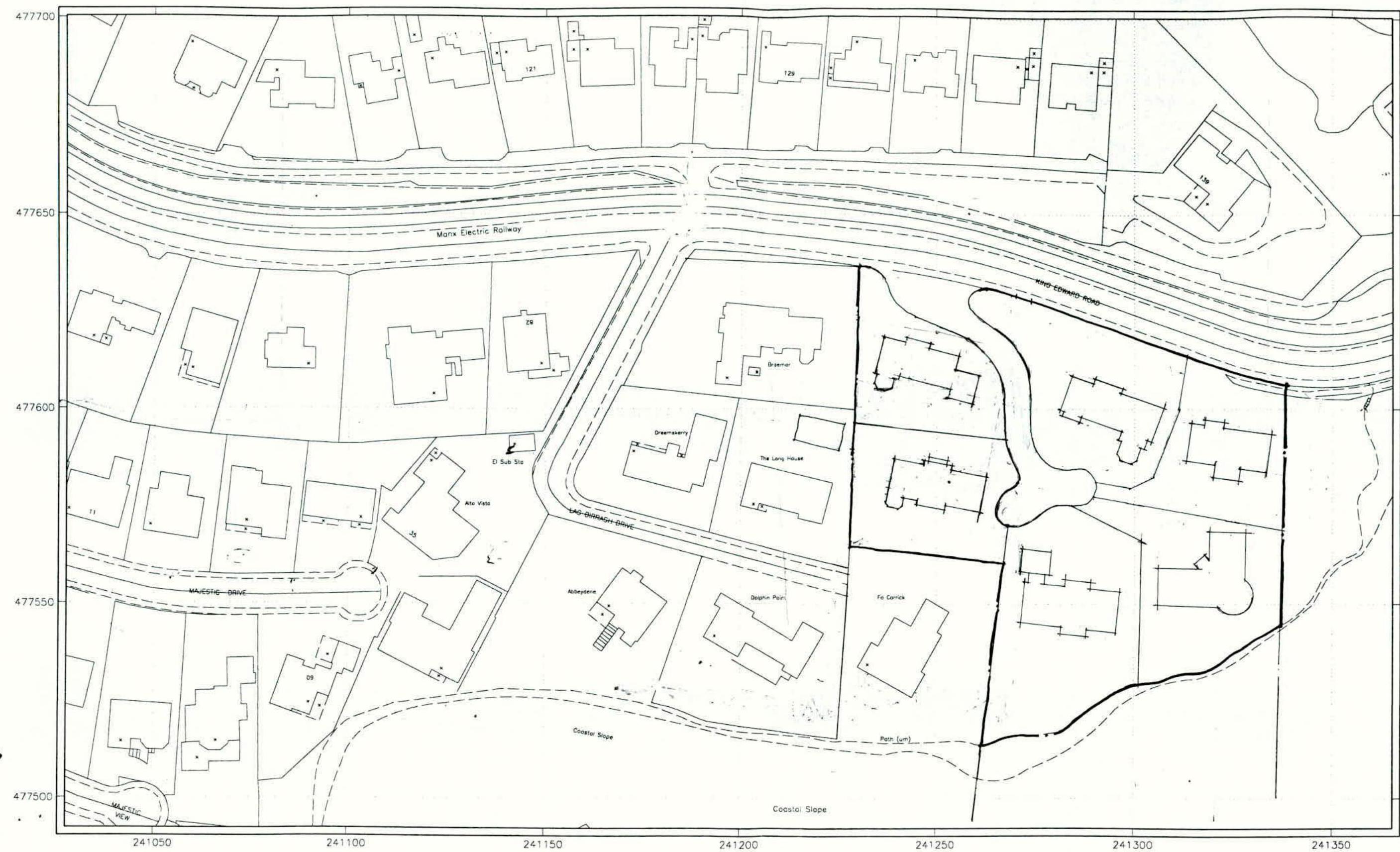
Taking consideration of the surrounding area, we then designed a Type 5A roadway from King Edward Road onto the site and ended the cul-de-sac with a turning head. This allowed for six plots of approx 0.4 of an acre each, which in this area is consistent with surrounding densities. Lag Birragh Drive plots are on average 0.4 of an acre, with Majestic Drive plots on average 0.2 of an acre. This would then provide two dwellings on the “Far End” site, and 4 dwellings on the adjacent site, with at least 20 metres between the main footprint of the dwellings on plots 1 and 2, and 35 metres between plots 3 and 6. We have included a boundary plan showing the proposed
dwellings and the surrounding developments at 1:1000, which clearly show the densities.
The design of the dwellings required to be of a high quality, but also needed to blend into the surrounding area so as not to become to prominent. The use of naturally laid stonework, face brick and rendered surfaces was decided, and this is prevalent in both Majestic Drive and Lag Birragh Drive.
The access to the site is basically in the same position as the original entrance to "Far End" but has been opened out and set back to comply with the requirements of the Department of Transport. In fact, various meetings have been held with the DOT prior to obtaining their approval. The splayed wall to the north east and south west of the entrance will be in stone no higher than 900mm thus providing maximum visibility in a north east direction. To the south west, visibility is again achieved to a max distance of 90 metres.
In conclusion, we feel this development of six dwellings with its 5A access and generous landscaping, will provide an aesthetically pleasing completion to this development area, and once completed should blend into the surrounding area.
Yours faithfully,
Dave Luton.
Encl. 1:1000 plan of surrounding area.
Note Map accuracy is dependant upon the scale at which the land was surveyed. For more information and a guide to the map symbols used please refer to information sheets available from the Land Registry.
Issued on: 25-May-2005 12:17:16 for Application no: 10104
For Registry Use Only App No: Date: Time:
Signatures(s):
Box 1
Signatures(s):
Box 2
Witness(es):
Date:
Witness(es):
Date:
A black and white site plan showing property boundaries, existing buildings, and nearby roads including the Manx Electric Railway.
Copyright in submitted documents remains with their authors. Request removal
Source & Provenance
Official reference
06/00212/B
Source authority
Isle of Man Government Planning & Building Control