Planning Statement For Siting Of A Container, Point Of Ayre
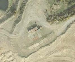
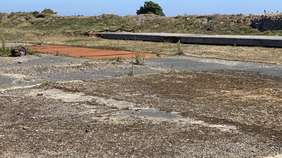
Aerial satellite view of a rural site featuring a small structure and dirt tracks.A photograph of a grassy, undeveloped plot of land featuring concrete slabs and a long concrete wall in the background, likely the site for the proposed nature reserve development.
1.0 THE SITE
1.1 The site is part of an area of a former sand and gravel quarry at the Point of Ayre, approximately 500m to the south west of the lighthouse. The overall site amounts to approximately 40ha (98 acres) and comprises former quarry workings which have naturalised and now include a large lake with uneven ground, some having naturally revegetated and with a path network running around the water body.
1.2 There are no buildings currently on the site. The most up to date aerial photograph shows a shed on the site however, this has since been demolished.
1.3 Access is available for motor vehicles from the public highway via a rough, wide lane which stops at a secured gate. No public access is currently available and the site is privately owned and managed as a bird sanctuary as an Area of Special Protection (ASP) for birds where special protection applies and access is restricted under the ASP Order and is subject to permission from the landowner. Bird Sanctuaries were designated under the Wild Birds Protection Act 1932. All wild birds in these areas are protected under their Orders and this includes protection from wilful disturbance of the nest or eggs. This reinforces the provisions of the Wildlife Act 1990 where:
All wild birds, their nests and eggs are protected by the Isle of Man Wildlife Act 1990. It is an offence, with certain exceptions, to:
1. intentionally or recklessly kill, injure or take any wild bird;
2. intentionally or recklessly take, damage or destroy the nest of any wild bird while it is in use or being built;
3. intentionally or recklessly take or destroy the egg of any wild bird;
4. have in one’s possession or control any wild bird (dead or alive), part of a wild bird or egg or a wild bird which has been taken in contravention of the Act;
5. intentionally or recklessly disturb any wild bird listed on Schedule 1 while it is nest building or is in, on or near a nest with eggs or young; or disturb the dependent young of such a bird.
A penalty of up to £5,000 for Schedule 1 species, or £2,500 for all other species can be imposed per offence.
1.4 A public footpath (17) runs to the southern edge of the site from Cranstal to the Ayres.
2.0 THE DEVELOPMENT
2.1 Proposed is retrospective approval for the siting of a container within the site, close to the entrance but out of public view. The container is dark green in external colour and has dimensions of 6m by 2.45m and is 2.9m high and is a typical rectangular cuboid shape.
2.2 The owners and managers of the site, which is being developed and managed as a nature reserve, have items they wish to store securely, items which are required for the development of the reserve. There are presently no buildings on the site although in the longer term, it is proposed to have a range of facilities here: these will not be available for at least five years and the charity managing the site has limited resources and is not completely sure at this early point in the project where the optimal location is for the storage of their equipment. The container, whilst not the most attractive, is not a permanent item and can and will be moved once a more permanent solution is afforded and available.
3.0 PLANNING POLICY
3.1 The site is designated on the Isle of Man Planning Scheme (Development Plan) Order 1982 as within an area of an area of High Landscape or Coastal Value and Scenic Significance, within a nature conservation zone, nature reserves and sits of ecological importance for conservation and with a small, oval shaped area identified as an area for surface mineral working (gravel).
3.2 The Cabinet Office is currently preparing an Area Plan for the North where there has been a submission for the land immediately to the south to be designated for mineral extraction (which is shown on the draft Proposals Map) with a 100m buffer zone at its boundaries. The most recent publication in respect of the new Area Plan includes references to environmental enhancement, referring to the Strategic Plan where it states:
“Opportunities for environmental enhancement, such as tree planting, the removal of eyesores and the management of habitats will need to be identified in Area Plans with the full involvement and support of local communities”. Such opportunities may include former mining areas which have been or are in the process of being reclaimed. Appropriate reclamation should protect or enhance features of industrial or archaeological significance.”
3.3 The document also states: “3. All statutory and important non-statutory designations in the North and West will be recorded on the Environmental, Community and Infrastructure Constraints Maps.”
3.4 There are no Registered Trees or Buildings on the site although the Point of Ayre lighthouses and foghorn are protected (RBs 147, 298 and 297) and it is not within any Conservation Area. Small patches of ground within the site are identified as being at risk of surface water flooding on the national flood risk maps.
3.5 The Landscape Character Assessment was published by Department of Environment, Food and Agriculture in and designates the application site and surrounding area to the north, west and east as Smooth Coastal Strip - G2 The Ayres and where the following advice is provided in the draft PPS The Role of Landscape Character in Development:
"Type G: Smooth Costal [sic] Strip The overall strategy for the protection and enhancement of the Smooth Coastal Strip Landscape Character Type is to conserve and enhance: the simple and uncluttered inter-tidal landscape; the strong sense of remoteness and tranquillity; the expansive seascape views dominated by extensive beaches and wide, open skies; and the diverse patchwork of highly sensitive coastal habitats.
Key landscape planning considerations in relation to the protection and enhancement of this Landscape Character Type are as follows:-
(a) Generally, housing and business development would be out of place within the predominantly visually open and uncluttered landscape of the Smooth Coastal Strip;
(b) Where built development is permitted, it should be small-scale, and buildings should avoid particularly exposed or visually prominent locations that would intrude into expansive views towards the sea, and should reflect local building materials and styles;
(c) Care should be taken to minimise urban influences within the undeveloped landscape;
(d) Sensitive design of coastal defences should be encouraged, such as to minimise adverse effects on the natural profile of the landscape;
(e) Where tourist and recreational development is required, it should be sensitively designed to respect local building materials and styles, and particular care should be taken to avoid development or infrastructure that would exert a strong urban influence over the surrounding landscape;
(f) Tall telecommunications development would be out of place within this predominantly open and highly visually sensitive landscape;
(g) The boundaries of sand and gravel extraction sites should include appropriate native structure planting to enhance the transition to the wider landscape; restoration schemes should be so designed as to strengthen the character of the Smooth Coastal Strip.”
3.6 As the site is not designated for a particular purpose on the development plan, there is a presumption against development here as set out in General Policy 3 and where Environment Policies 1 and 2 protect the countryside and the landscape quality as the most important considerations.
3.7 General Policy 3 sets out exceptions to this general presumption including “(h)buildings or works required for interpretation of the countryside, its wildlife or heritage”.
3.8 Ecology is protected in Environment Policy 4 including species of international, national or local importance, designated National Nature Reserves, Areas of Special Protection and Bird Sanctuaries. More specifically, watercourses and wetlands and their associated ecology are protected in Environment Policy 7 which also requires applications which could cause
demonstrable harm to a watercourse, wetland, pond or dub to demonstrate how this will not happen including phasing and details of the works involved.
4.0 PLANNING HISTORY
4.1 The site has been the subject of a recent application - 21/00929/B which is currently awaiting determination. This application proposes the creation of three ponds, the repair of a gravel bund and creation of two gravel islands within the site all related to the ecological enhancement of the site. The land round about has been the subject of years of proposals for mineral extraction and waste disposal, some of which involve restoration of these sites post-completion, for nature conservation with a longer term objective of public access and facilities for visitors to understand and observe the wildlife whose habitats are being protected and enhanced.
5.0 CONCLUSION
5.1 The works are a temporary solution to the need for storage facilities and will enable the Manx BirdLife charity to continue to develop the site with a more permanent, more appropriate storage facility in the future when the funds are available and the optimal form and location are identified. The container is not publicly visible and whilst it may be usual to require a landscaping scheme to screen the view of a structure like this, it is important to maintain the natural character and ecology of the site and as such, the introduction of new planting which would quickly and effectively screen the container would be inappropriate, added to which, the container is not a permanent solution to the storage issues presently facing the charity.
5.2 The items to be stored are associated with the maintenance and development of the site in the interests of nature with an ultimate objective of having public access to the site and facilities for the appreciation and interpretation of the wildlife that is being protected and enhanced, and as such the development is considered to go towards satisfying General Policy 3h of the Strategic Plan and protecting the countryside in accordance with Environment Policies 1 and 2.
Copyright in submitted documents remains with their authors. Request removal
Source & Provenance
Official reference
21/01208/B
Source authority
Isle of Man Government Planning & Building Control