Loading document...
MINE SPOIL IS EXISTING WITHIN A DEVELOPMENT AND IT IS UNREALISTIC TO REMOVE/CAP IT, THEN ADEQUATE LANDSCAPING SHOULD BE SPECIFIED.
THIS MAY INCLUDE A LOW-COST SOLUTION OF REVEGETATION WITH INDIGENOUS SPECIES PROVIDED THAT THE DEPARTMENT CAN BE SATISFIED THAT AN ADEQUATELY STABLE SURFACE CAN BE CREATED. THIS IS PARTICULARLY IMPORTANT WHERE SLOPES IN SPOIL ARE ADJACENT TO STREAM COURSES AND IN SUCH CASES THE GOVERNMENT MAY WISH TO ENTER INTO A JOINT SCHEME TO OBTAIN OTHER BENEFITS FOR THE COMMUNITY SUCH AS AN ACCESS, NATURE TRAIL OR RIVER BANK STABILISATION PROGRAMME.
IF POSSIBLE, ANY FUTURE LANDSCAPING SCHEME SHOULD INCLUDE AN AREA OF IMPEDED DRAINAGE IN THE HOPE THAT NATURE CAN BEASSISTED TO RE
CREATE THE VARIED AND VALUABLE PLANT COMMUNITY PREVIOUSLY EXISTING AND INCLUDING NORTHERN MARSH ORCHID DACTYL ORCHIS AND ADDERSTONOUE FERN. OPHIO GLOSSUM VULGATUM.
MADE OR CUT INTOTOXIC FILL/MINE WASTE ADEQUATE ATTENTION MUST BE PAID TO SLOPE STABILITY, LIKELIHOOD OF GULLYING OR OTHER THREATS WHICH MAY MOBILISE TOXIC MATERIALS TO THE ENVIRONMENT.
SHOULD SHOW HOW ANY TOXIC FILL IS TO BE PREVENTED FROM BEING MOBILISED BOTH DURING THE COURSE OF DEVELOPMENT AND AFTERWARDS.
GRANTED SUCH THAT ADEQUATE AFTER CARE/LANDSCAPING IS UNDERTAKEN.
FURTHER TO THE GOVERNMENT OBTAINING OTHER BENEFITS FROM THE DEVELOPMENT, SUCH AS A NATURE TRAIL, THE MANX NATURE CONSERVATION TRUST MAYBE OF ASSISTANCEIN TERMS OF PRACTICAL LAND MANAGEMENT TO CONSERVE AND ENHANCE THE HABITATS AND THEIR CONSTITUENT FLORA AND FAUNA PRODUCTION OF A NATURE TRAIL PROVISION OF INTERPRETATION BOARDS, LEADING GUIDED WALKS AND FIELD STUDY/EDUCATIONAL COURSES, GIVING TALKS AND SLIDESHOWS TO THE LOCAL COMMUNITY AND OTHER GROUPS.
WHERE A SITE IS NOT THOUGHT TO BEHEAVILY CONTAMINATED AND THERE IS CONSIDEREDONLY SLIGHT RISK OF CONTAMINATION OR GEOTECHNICAL HAZARD, THE BENEFITS OF GENERAL RESTORATION ARE VERY MUCH LESS AND ARE NOT LIKELY TO BE PRACTICAL. HOWEVER, ITIS POSSIBLE THAT SOME CONTAMINATION MAY BE UNCOVERED OUTSIDE THE MOST HEAVILY CONTAMINATED AREAS AND AS SUCH,
THE FOLLOWING GUIDELINES SHOULD BE APPLIED TO THOSE AREAS INDICATED ON FIGURE 2 AS BEING SLIGHTLY AT RISK: i. ALL PLANNING APPLICATIONS MUST CONTAIN EVIDENCE IF POSSIBLE OF A SEARCH OF OLD RECORDS CONCERNING MINING ACTIVITIES WHICH MAY HAVE AFFECTED THE AREA OF THE PROPOSED DEVELOPMENT. ii. PLANNING APPLICATIONS MUST CONTAIN REFERENCE TO THE NATURE OF ANY SPOIL MATERIAL, MADE GROUND, OLD/DERELICT STRUCTURES AND DEMONSTRATE THAT THESE HAVE BEEN INVESTIGATED. WHERE DISTURBED OR MADE GROUND OCCURS SOME LIMITED GEOCHEMICAL DATA SHOULD BE PROVIDED. iii. SOIL SAMPLES (AT INTERVALS OF APPROXIMATELY 1 OR 2 PER ACRE) MUST BE TAKEN AND ANALYSED SEMIQUANTITATIVELY TO DETERMINE THE GENERAL LEVEL OF CONTAMINATION. iv. SOAKAWAYS SHOULD BE AVOIDED. WHERE DRAINS OR DITCHES ARE CUT IN SUSPECT TERRAIN (MADE OR DISTURBED GROUND) THEY SHOULD BE ARMOURED, CASED OR PIPED. THE FALL ON DRAINAGE PIPES SHOULD BE SUCH AS TO AVOID
STANDING WATER AND THE OUTFALL OF PIPES SHOULD NOT BE INTO STREAMS WHICH ARE THEMSELVES CUT INTO SPOIL. v. ALTERATIONS TO LAND DRAINAGE SHOULD BE SUCH AS TO ADD VALUE TO THE OVERALL DRAINAGE NETWORK OF THE AREA BY BEING DESIGNED TO EXPORT WATER INTO A NETWORK WHICH IS ISOLATED FROM CONTAMINATED MATERIAL. DRAINAGE OUTFALLS SHOULD NOT EMPTY INTO CONTAMINATED LAND. vi. EXCAVATIONS WHICH OCCUR DURING THE PROCESS OF DEVELOPMENT SHOULD BE PERIODICALLY INSPECTED FOR SIGNS OF MADE GROUND/ DUMPED SOIL AND ANY SUCH MATERIALS REMOVED TO A CONTAMINATED SITE OR ISOLATED BY APPROPRIATE MEANS. vii. WATER FROM ISSUES, SPRINGS, WELLS OR SUBSURFACE PIPES SHOULD NOT BE USED FOR DOMESTIC SUPPLY AND IRRIGATION OF CROPS FOR HUMAN CONSUMPTION WITHOUT THE GOVERNMENT FIRST BEING SATISFIED AS TO ITS QUALITY AND SUITABILITY. viii. ALL COMMERCIALARABLE LAND-USE WHICH WOULD GROW
CROPS FOR DOMESTIC CONSUMPTION SHOULD BE AVOIDED UNLESSAFULLSURVEY OF SOIL QUALITY AND LIKELY HEAVY METALUPTAKEN BY SPECIFIED CROPS IS UNDERTAKEN.
ELSEWHERE IN THE VILLAGE THERE IS A RISK OF ISOLATED POINTS OF CONTAMINATION AND GEOTECHNICAL HAZARD. BY AND LARGE THESE ARE KNOWN FROM HISTORICAL RECORDS (SHAFTS, PITS, ENGINE HOUSE ASH MOUNDS, COLLAPSED BUILDINGS, ETC.) OR RELATE TO SMALL POCKETS OF SPOIL RELOCATED FOR HARDCORE OR FILL. THIS PROBLEM IS BEST ADDRESSED BY EACH PLANNING APPLICATION BEING REFERRED TO ARCHIVED RECORDS FOR THE LIKELY PRESENCE OF MINING ACTIVITY/ BUILDINGS, ETC. WHERE A POTENTIAL HAZARD IS IDENTIFIED GROUND INVESTIGATION IS NEEDED IF IT IS TO BE DISTURBED OR IF THE PROPOSED DEVELOPMENT INCREASES THE LIKELIHOOD OF DANGER TO THE HUMAN POPULATION (SUCH AS LOCATING RESIDENTIAL BUILDINGS NEARBY).
WHERE RECENT DEVELOPMENT OR IMPROVEMENT HAS ALREADY TAKEN PLACE IN AREAS PREVIOUSLY OCCUPIED BY MINE SPOIL,WASTE, E.G., NEW PRIMARY
SCHOOL, GAREY CLOSE, CLOCKTOWER INDUSTRIAL ESTATE, ETC., RECLAMATION WORK HAS ALREADY BEEN CARRIED OUT. HOWEVER CONTINUED MONITORING OF THESE SITES SHOULD BE MAINTAINED AND IN CASES WHERE FURTHER DEVELOPMENT OR REDEVELOPMENT OF THESE SITES IS PROPOSED PLANNING APPLICATIONS WILL BE CONSIDERED AS FALLING INTO SITES DESCRIBED IN PARA. 2.2.i.
2.21 A large part of the village falls within much wider Nature Conservation Zone identified on the 1982 Development Plan as recommended in the Report "Nature Conservation in the Isle of Man" undertaken by the Nature Conservancy Council and the Institute of Terrestrial Ecology in 1974 (see fig. 3). The purpose of this zone is to "maintain existing characteristics as far as possible, entailing the exercise of planning and other constraints on activities liable to bring about substantial changes in their overall character, such as damage to the land form, vegetation, fauna or hydrological balance." (Part 1:4i) 2.22 The boundary of the Nature Conservation Zone includes areas of intensively managed agricultural land of relatively little ecological value. This particular zone is part of a much larger zone centred on the South Barrule upland mass and includes areas which could be classed as "buffer zones", shielding areas of higher or true ecological interest or importance. Since the areas of Ecological Importance for Nature Conservation were identified in 1974, the majority of Stoney Mountain and Windy Common have been planted with coniferous trees. It is important that these trees are checked and prevented from becoming a close canopy as this will significantly damage the ecological value of the land itself. If the trees are held in check then the land may continue to be of ecological value and possibly provide feeding and breeding sites for important birds such as the hen harrier and crossbill, both of which are protected under the Wildlife Act 1990. 2.23 The Department of Agriculture, Fisheries and Forestry has the principal responsibility for nature conservation through the Wildlife Act 1990 and through their facility to designate areas of interest or for special protection. 2.24 As well as specific zones of interest, certain bodies have responsibilities for conservation pertinent to the village. The Manx Museum and National Trust, now known as Manx National Heritage, is the statutory arm of Government charged through the Manx Museum and National Trust Acts 1959-86 with protecting, preserving and promoting all aspects of the Manx natural and cultural heritage. Manx National Heritage is concerned with sites of archaeological, historical, architectural, geological, ecological and environmental potential and scrutinises all planning applications with a view to commenting to the Planning Committee on any application which may affect such a site. 2.25 The above bodies, together with the Wolverhampton Study, have identified areas of ecological interest (see fig. 3) whose intrinsic characteristics themselves justify a best end-use of purely conservation, given other environmental limitations: i. The area below the Kionsliesu Dam valuable for the Fir Clubmoss Lycopodium Selago on the old washing floor. Also of interest is the wet
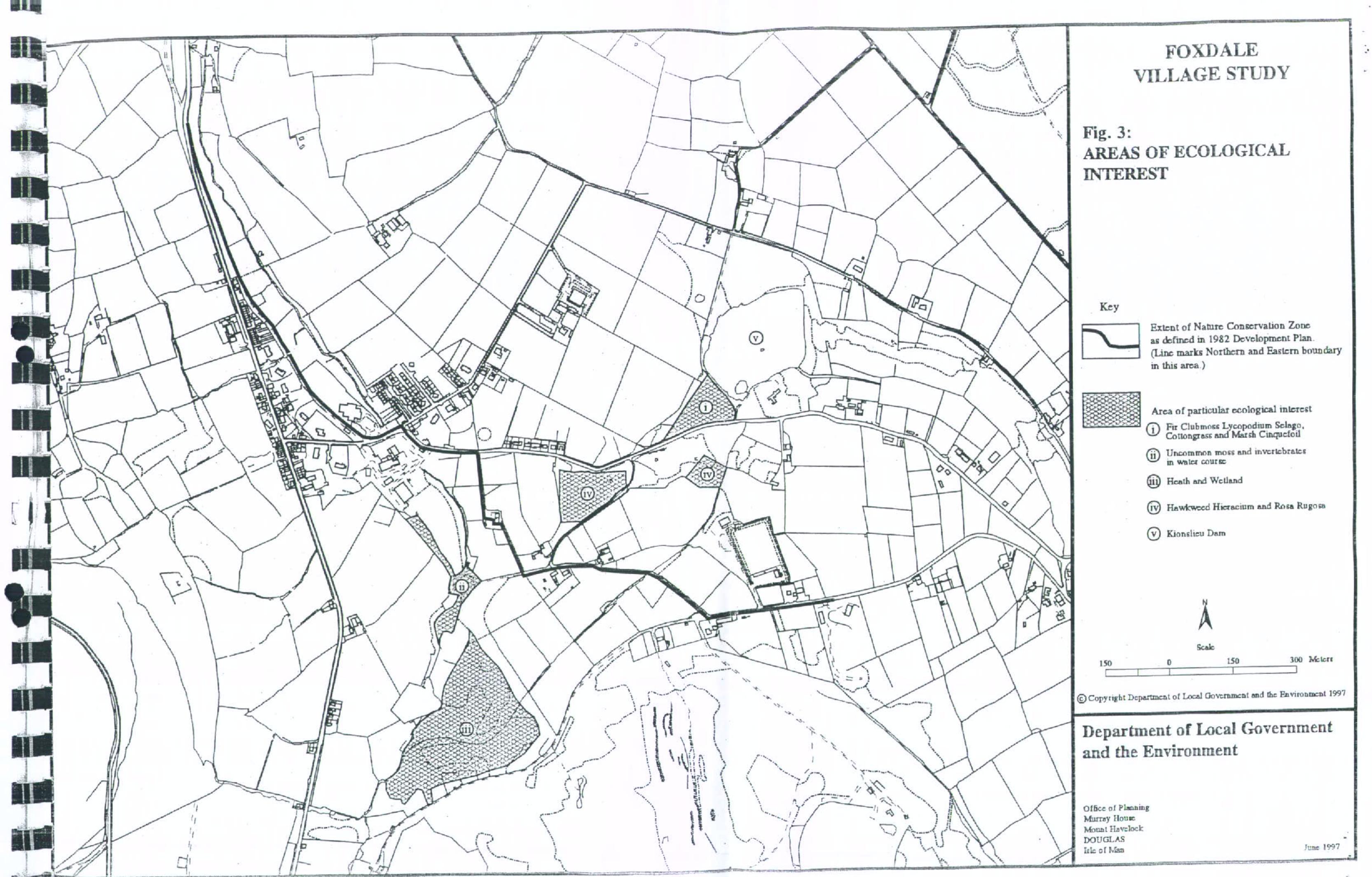
depression inhabited by Cottongrass and Marsh Cinquefoil. ii. The area around Maghie's Quarry where there is uncommon moss present on the bared sides of the water courses between it and Bawden's Shaft and within the water courses is a variety of invertebrates. iii. The coniferous plantation/heath/ wetland below Stoney Mountain. This is important due to the heathland and wetland which were present long before the conifers were planted and yet persists still because the trees are stunted and held in check. Management of the site is required to conserve and enhance the ecology and would involve the lopping and felling of conifers where these would threaten to shade out the native vegetation. iv. The part of the central and south western area of the Louisa mine site, the southern side of which accommodates Hawkweed Hieracium, a rare genus in Man, and the vegetated area downstream of this with naturalised Rosa rugosa should be protected. v. An area of heathland on the eastern slope of the Barrule uplands which represents a significant area of heathland which is considered of sufficient interest to warrant consideration for status as an Area of Special Scientific Interest (ASSI) under the provisions of the Wildlife Act 1990. 2.26 In addition to the above the Kionstieau Dam is a very important feature of ecological interest. The Dam, coupled with the adjacent Eairy Dam and the area joining the two represent a complex of open water, marginal inundation vegetation, reedbed, wet heath, marshy grassland and curragh and is almost certainly the best example on the Island of aquatic succession. Its diversity of habitat, flora and fauna together with its potential for environmental education and interpretation and informal recreation make it another candidate for designation as an Area of Special Scientific Interest. 2.27 With the exception of area iii above which may be an area which the Manx Nature Conservation Trust could manage as Nature Reserve on behalf of the Department of Agriculture, Fisheries and Forestry, it is not felt that any of the sites mentioned in 2.25 above warrant designation as Areas of Special Scientific Interest (ASSI) or National Nature Reserves (NR). Areas of Special Scientific Interest are afforded special protection against certain actions which would threaten the interest or importance of the site and would afford protection of the site irrespective of any planning permissions or land use designations which may prevail. 2.28 It would seem most appropriate therefore to promote the protection of these sites as informal open space on the basis of a subdivided nature park linked by a footpath system/Heritage Trail with appropriate interpretation. Practical and financial assistance and management advice should be obtained from the Department of Agriculture, Fisheries and Forestry and the Manx Nature Conservation Trust.
THE POLICY AND PROGRAMME IDENTIFIED AND RECOMMENDED IN THE REPORT "NATURE CONSERVATION IN THE ISLE OF MAN" SHALL REMAIN VALID AND SHOULD CONTINUE TO BE PURSUED BY THE APPROPRIATE AUTHORITIES. THAT IS: i. incorporation of information about zones and sites into the Town and Country Planning process and especially by designation of Nature Conservation Areas in the Isle of Man Development Plan; ii. establishment of a framework of policy and procedures for the use and management of land and water for nature conservation within designated zones and sites; iii. strengthening of existing institutes with particular responsibilities for nature conservation especially so as to provide executive and advisory support in this field, not only for those concerned with designated zones and sites but more widely for users of land and water throughout the Island; iv. establishment of machinery for encouraging all who influence the use of management of land and water including the public at large and the owners and occupiers of land to safeguard their natural heritage; v. development of environmental education in schools and other
educational institutes and especially the promotion of field studies enabling young people to familiarise themselves with their environment and its natural features and vi. development of an ecological survey and monitoring programme to ensure that relevant knowledge about the Island's natural features is continuously updated and used to further conservation.
IT SHOULD BE NOTED THAT THE ISLAND NOW HAS A MORE UP-TO-DATE SYSTEM OF THE SITE IDENTIFICATION IN THE FORM OF THE DEPARTMENT OF AGRICULTURE, FISHERIES AND FORESTRY PHASE ONE HABITAT SURVEY AND SUBSEQUENT SURVEYS UNDERTAKEN PHASE TWO. IN THIS RESPECT SUBPARAGRAPH VI IS BEING UNDERTAKEN AND WILL BE CONSIDERED BY THE DEPARTMENT AS PART OF ITS DECISION-MAKING PROCESSES.
THE INTERESTS AND STATUTORY RESPONSIBILITIES OF THE DEPARTMENT OF AGRICULTURE, FISHERIES AND FORESTRY SHALL BE RECOGNISED, IN PARTICULAR WITH REFERENCE TO THE CONTENTS AND OBJECTIVES OF THE WILDLIFE ACT 1990 AND NATURE CONSERVATION ZONE INCORPORATED IN THE 1982 DEVELOPMENT PLAN ORDER.
THERE SHALL BE A BASIC PRESUMPTION AGAINST ANY DEVELOPMENT WHICH, IN THE OPINION OF THE PLANNING COMMITTEE HAS AN ADVERSE IMPACT ON AREAS OF ECOLOGICAL INTEREST OR VALUE FOR NATURE CONSERVATION.
Copyright in submitted documents remains with their authors. Request removal