Loading document...
HAVEN HOMES LIMITED THE OLD CHAPEL 32-34 MALEW STREET CASTLETOWN ISLE OF MAN IM9 1AF PHONE 01624 835222 EMAIL [email protected] WEB WWW.HAVEN.IM
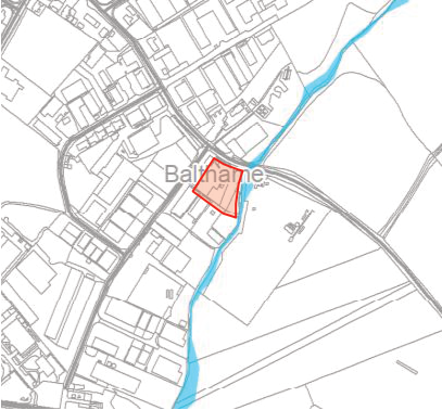
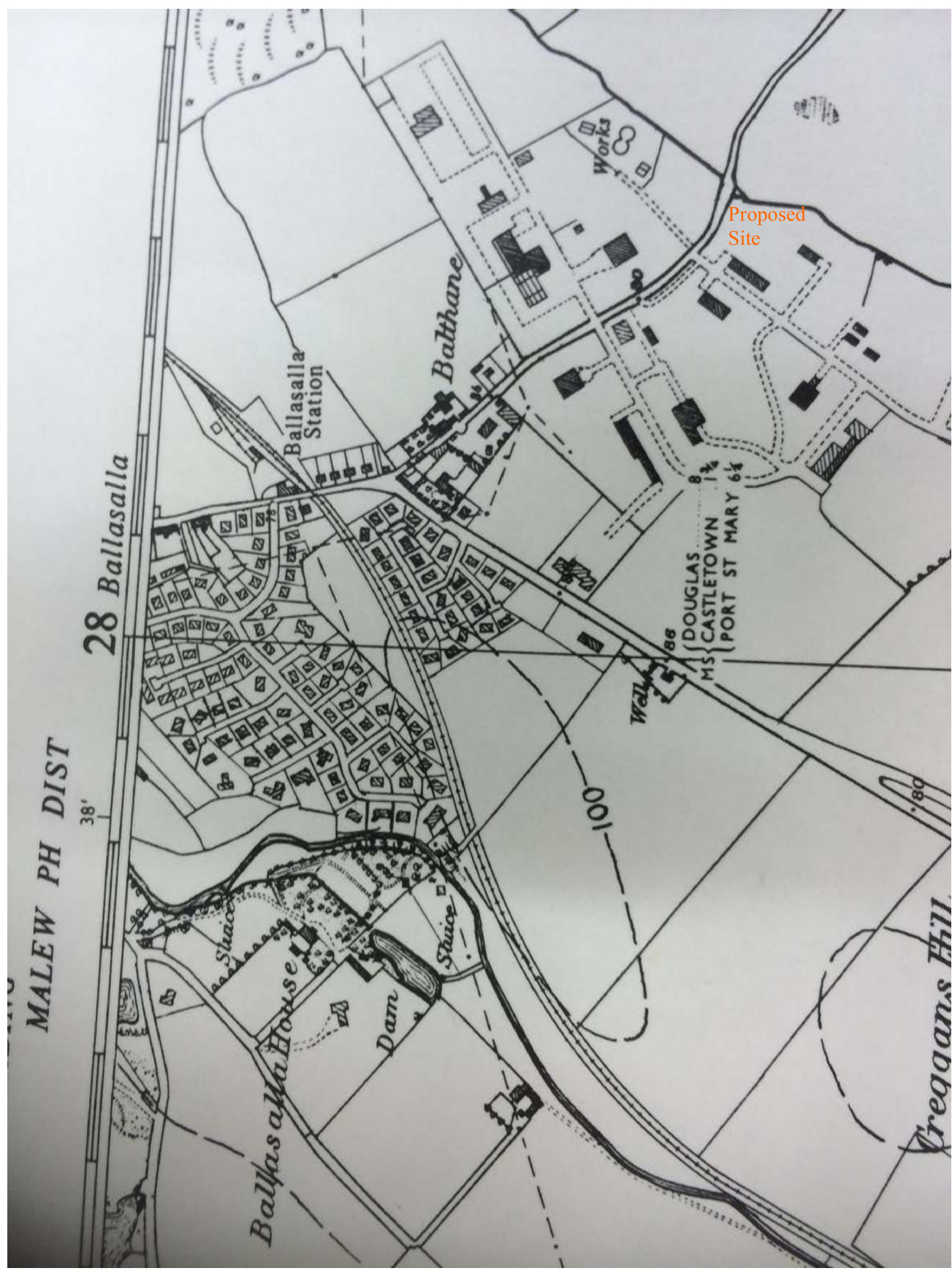
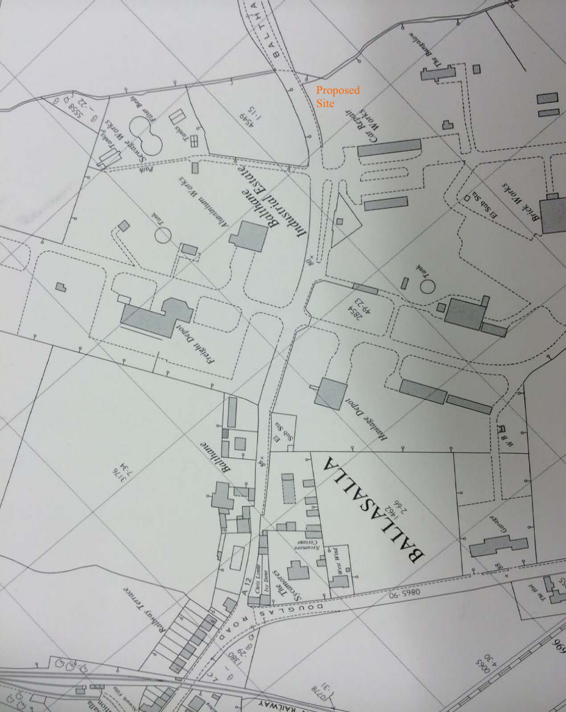
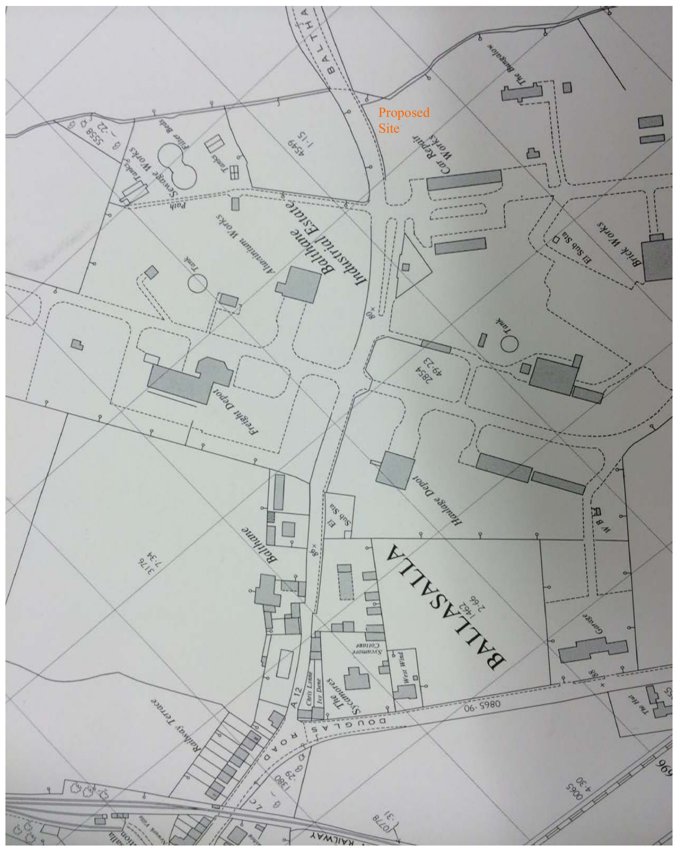
or Storage and Distribution, Together With Associated Parking - at FORMER GAS STORAGE FACILITY Balthane Industrial Estate, Ballasalla, Isle Of Man IM9 2AG
n) to the north-east by Balthane Road; e) to the south-east by a watercourse referred to as the
“Ronaldsburn” with a recycling facility to the far side of the watercourse operated by JCK Limited.
s) to the south-west by industrial units including a yard and offices of JCK Limited and also a residential property referred to as “The Court”; and
w) to the north-west by industrial units;
A number of applications have been submitted concerning the same Site.
This approval was apparently exercised.
“Installation of 2 no. additional 24 tonne LPG storage tanks.”
This approval was apparently exercised.
“Approval in principle for the demolition of existing gas storage facility and erection of 11 light industrial units and associated parking.”
“Approval in principle for the demolition of existing gas storage facility and erection of 11 units for purposes of general industrial or light industrial or storage and distribution along with associated parking.”
This approval remains extant pursuant to its first condition and §14 of the Town and Country Planning (Development Procedure) № 2) Order 2013:-
“The development hereby approved shall be begun either before the expiration of four years from the date of this approval or before the expiration of two
years from the date of approval of the last of the reserved matters.”
Although the approval in principal remains extant, time limitation for submission of a Reserved Matters application was reached two years after the date of the approval, pursuant to the second condition. The associated Decision Notice is appended in full to this Statement (cf. Appx. A).
“Demolition of existing gas store, levelling of site and construction of retaining walls. Use of site for the medium term storage of site vehicles, containers and building materials.”
This approval remains extant pursuant to its first condition:-
“This approval relates to the use of the site for the storage of construction equipment, vehicles and materials until 31st December, 2027.”
The associated Decision Notice is appended in full to this Statement (cf. Appx. B). This application is currently in the process of being exercised, with much of the development (thought to have been approved under P.A. 88/00792/B and P.A. 96/00020/B) having been demolished.
The stone wall to the north-east boundary (cf. §2.6) would be demolished. The existing entrance radii of 5.0m would be enlarged to a proposed 7.5m;
The existing Site entrance width of 3.8m would be widened to 6.1m. The primary access routes through the courtyard would be 6.1m wide. Where this splits into 2 routes, to either side of Block B, both routes would also have 6100mm clear width;
Although no entrance gates are proposed, there would be a minimum 10m of clear space from the edge of the carriageway of Balthane Road;
The vehicular access would have a gradient of 1:24 for a length of approximately 10m from the edge of the carriageway of Balthane Road into the Site.
The vehicular access is situated to the outside of a bend on Balthane Road, giving good visibility in both directions. Visibility splays are shown on the basis of x=2.4m and y=59.0m, derived from a stated Stopping Sign Distance (SSD) at 37 miles per hour, adjusted for bonnet length, as shown in Table 7.1 of MfS [Department for Transport, Manual for Streets, Thomas Telford Publishing, 2007].
Where the two access routes meet at the centre of the courtyard, a 15m diameter clear space is provided with a further 9m × 5m adjacent reversing space given, formed by the access to Unit №s 08 and 09. Swept path analysis has been carried out by BB Consulting Engineers Limited, demonstrating the manoeuvrability of the largest vehicle type anticipated.
11.6m Refuse Vehicle Overall Length 11,600 mm Overall Width 2,530 mm Overall Body Height 3,211 mm Minimum Body Ground Clearance 416 mm Track Width 2,530 mm Lock-to-Lock Time 4.0 seconds Kerb-to-Kerb Radii 9,950 mm
The above vehicle would be capable of manoeuvring within the Proposal by way of a three-point turn as shown in swept-path analysis provided by BB Consulting Engineers Limited.
“this site is not a significant contaminated area, according to the testing indicators [...] and should not be classified as Contaminated Land”
Permission is expressly sought under the Application to fell the remaining 9 № trees, T.06 to T.14 inclusive, in order to facilitate the redevelopment of the Site to its full potential as zoned in the Area Plan.
“In the case of any inconsistency between the provisions of the Strategic Plan and the provisions of an Area Plan, whichever came into force later will prevail.”
The Strategic Plan came into force later than the Area Plan. The Strategic Plan prevails in the event of any inconsistency.
8.3 Strategic Plan, General Policy 2 contains 14 № subsections, which are addressed in turn:
“Development which is in accordance with the land-use zoning and proposals in the appropriate Area Plan and with other policies of this Strategic Plan will normally be permitted, provided that the development:
The Site is part of that land keyed on Map 4 to the Area Plan as having Industrial/Business Park land-use zoning, and is labelled “Ind”. The Site is not shown as being within any Proposal Site defined in the Area Plan Written Statement or explicitly identified on Map 3 to the Area Plan. The Site is not, therefore, the subject of a Development Brief or design brief.
The Proposal has been designed to employ the Site as effectively as possible in its redevelopment, and has balanced the massing and situation of blocks A, B and C (cf. §4.2) with the surrounding built and natural environment. In this respect, appropriate margins are proposed from adjacent properties and the adjacent watercourse.
The character of the BIE is described, in somewhat critical terms, at §6.8.2 of the Area Plan Written Statement:-
“[...] The Estate is used by a mix of businesses but incremental development, poor maintenance of buildings, roads and footways, has over the years, resulted in the Estate appearing neglected and unattractive in many parts giving a poor impression to the public, customers and businesses alike. It is recognised that the Estate is home to some uses which are essential to support the Island and also that there is scope for the general appearance and access to the Estate to be improved. There is considerable land available at Balthane which was first identified on the 1982 Development Order. It has been deemed appropriate to carry forward this designation into the Area Plan but there is a need to secure improvement works on the Estate.”
The character of the Proposal seeks to provide a contemporary appearance where it faces the public highway by providing extensive areas of attractive glazed curtain walling (cf. §4.5). This is considered an improvement not only to the current condition of the Site itself, but also the attractiveness of the particular section of Balthane Road where it runs through the BIE.
Environmental considerations in respect of the Ronaldsburn watercourse are set out at §7.2 of this Statement.
The Site is not in an elevated position relative to the surrounding landscape. The surrounding natural topography precludes views towards the sea at ground level. The Proposal cannot, therefore, be said to affect public views of the sea.
During the design development of the Proposal it became apparent that, given certain criteria (including quantum of parking and surface water attenuation), the position of the existing trees would considerably limited the redevelopment potential of the Site if they were to remain. As discussed previously (cf. §7.3), the trees found on the Site are not considered to add significantly to the visual amenity of the Site, nor the ecological amenity. The planning officer’s report in respect of P.A. 13/91404/A (cf. §3.3), at §6.3, notes:-
“[...] The proposal would result in the loss of some existing landscaping which fronts onto the main highway, although this is not maintained currently and does not add especially to the visual amenities of the industrial estate. The submitted layout would result in the frontage of the site being hard surfaced to be utilised for parking. Whilst this is not beneficial to the street scene, this layout is very common within the industrial estate and similar arrangement has recently been approved nearby (13/00197/B). Overall, it is considered an arrangement of units as shown would be appropriate for the site, and would potentially not unduly affect the visual amenities of the street scene.”
The Applicant concurs with the Planning officer’s findings. Moreover, the natural topography of the brown field Site has already been affected by its previous use as a gas storage facility. The Site has extant planning consent to level the Site to the topography required by the Proposal (cf. §3.5), which is also necessary for the surface water drainage strategy and the interception of pollutants from entering the Ronaldsburn.
The nearest residential property is referred to as The Court. The planning officer’s report in respect of P.A. 13/91404/A (cf. §3.3), at §6.5, notes:-
“[The Court] is a single storey bungalow located 20.8 metres to the southeast of the proposed unit 4. This unit would be the unit which would most affect the amenities of the occupants of this property. [...] There are no detail designs of the proposed units, so a full assessment cannot be made at this stage. However, it is considered the scheme as shown, with unit four siting, distance and directly facing the gable end of the property, it is considered this would not significantly affect the residential amenities (loss of light and/or overbearing impact) to warrant a refusal[...]”
The detailed design of Unit № 04 has considered the effect on residential amenity so as not to cause loss of light or otherwise an over-bearing impact through its massing.
The proposed parking provision is set out at §5.1 and compliance with Parking Standards is set out at §8.5 of this Statement.
As discussed at §5.2(e) of this Statement, the Proposal makes use of an existing access with good visibility. Minor adjustments have been made to a design previously submitted for Approval in principle, in order accord with the relevent criteria of the MfMR, a guidance document published following the Planning applications previously made in respect of the Site. The planning officer’s report in respect of P.A. 13/91404/A (cf. §3.3), at §6.4, notes:-
“[...] Highway Services have considered the scheme in terms of parking standards, manoeuvrability of vehicles within the site and highway safety matters and have no objection to the proposal.”
As set out at §5 of this Statement, the Applicant submits that the minor adjustments made following the issuance of MfMR by the Department of Infrastructure are an improvement in terms of manoeuvrability, visibility and pedestrian safety.
All land parcels surrounding the Site have already been developed. The Proposal would not prejudice the existing uses of the surrounding land. Moreover, those already established uses of the surrounding land would not preclude the proposed use sought for the Site.
It is established that the land of the Site should not be treated as contaminated land (cf. §7.1) and that there is no flooding risk to, or otherwise arising from, the Proposal (cf. §6.1)
The proposal is designed with due regard to security and personal safety. Previous concerns regarding the conflict of vehicular and pedestrian traffic have been addressed through the increased manoeuvrability space and sufficient margin from all vehicular movements to all pedestrian accesses.
The proposal is designed with due regard to the reduction of energy consumption, with a scheme that will comply with the requirements of Building Regulations. The arrangement of the units themselves is made to maximise their versatility, with the anticipation that they be re-purposed as required for various uses during the course of their life cycle.
The proposal accords with all subsection requirements of General Policy 2.
8.4 Strategic Plan, Business Policy 5 states:
“On land zoned for industrial use, permission will be given only for industrial development or for storage and distribution; retailing will not be permitted except where either:
Area Plan, Employment Proposal 1, under §6.8.7 states:-
“All industrial uses, other than small scale light industrial uses considered to be acceptable within the Mixed Use areas, or those uses deemed appropriate by the Isle of Man Strategic Plan Business Policy 7, will be located on the Industrial Estate at Balthane and where appropriate Ronaldsway and the Freeport.”
The planning officer’s report in respect of P.A. 13/91404/A (cf. §3.3), at §7.1, concludes in its recommendation:-
“[...] it is considered that the planning application is in accordance with General Policy 2 and Business Policy 5 of the Isle of Man Strategic Plan 2007 and the Area Plan for the South [...]”
In this respect the Proposal remains unaltered. The Proposal remains compliant with Business Policy 5.
8.5 Strategic Plan, Transport Policy 7 states in full:-
“The Department will require that in all new development, parking provision must be in accordance with the department’s current standards”
The current standards are set out at Appendix 7 of the Strategic Plan. Each Type of Development gives a respective parking requirement by floor area. These include, inter alia:-
“Light industrial, research and development: 1 space per 30 square metres nett floor space.” “General industrial: 1 space per 50 square metres gross floor space.” “Storage and distribution: 1 space per 100 square metres gross floor space.” The Strategic Plan, at §9.2.3 provides the following definitions.
“‘light industrial building’ means an industrial building (not being a special industrial building) in which the processes carried on or the machinery installed are such as could be carried on or installed in any residential area without detriment to the amenity of that area by reason of noise, vibration, smell, fumes, smoke, soot, ash, dust or grit, or undue generation of traffic or parking of vehicles; the use of light industrial buildings for research and development of products or processes is permitted by the Town and Country Planning (Permitted Development) Order 2005.
‘general industrial building’ means an industrial building other than a light industrial building or a special industrial building;
‘special industrial building’ means an industrial building used for the carrying on of processes (including storage) which may be particularly offensive by reason of noise, smell, vibration, smoke, soot, ash, dust, grit, or fumes, or dangerous by reason of the storage or use of dangerous or inflammable material, or inimical to public health by reason of vermin or other causes.”
For the purposes of measuring the maximum required number of parking spaces that would be required by the Proposal, the whole of the Site is measured against the Light industrial, research and development Type of Development, or 1 space per 30m2 nett floor space, notwithstanding that General industrial and Storage and distribution uses are also sought in respect of the Proposal and that these uses have a lower parking requirement. The nett floor areas for each block stated at §4.2 of this Statement are:-
This gives a total nett floor area of 1491m2 and a parking requirement of 49.7 parking spaces at 1 space per 30m2 nett floor space. The parking provision is described at §5.1 and notes that 50 № car and van parking spaces would be provided. The planning officer’s report in respect of P.A. 13/91404/A (cf. §3.3), at §6.4, notes:-
“[...] Highway division have considered the scheme in terms of parking standards, manoeuvrability of vehicles within the site and highway safety matters and have no objection to the proposal.”
The proposal strictly complies with Transport Policy 7, notwithstanding that the uses sought and possible omission of mezzanine floors have the potential to reduce the actual parking provision requirement. Although there has been further amendment to the layout over that previously submitted for Approval in principle, this has been made to further improve manoeuvrability and in accordance with the street type requirements of MfMR (cf. §5), a document which has since been issued by the Department of Infrastructure.
Hugh Logan Architects Bridge Court 10 Bridge Street Castletown
TOWN AND COUNTRY PLANNING ACT 1999 The Town and Country Planning (Development Procedure)(No 2) Order 2013
In pursuance of powers granted under the above Act and Order the Department of Environment, Food and Agriculture determined to APPROVE an application by Haven Homes Ltd, Ref 16/00423/A, for the Approval in principle for the demolition of existing gas storage facility and erection of 11 units for purposes of general industrial or light industrial or storage and distribution along with associated parking, at Former Gas Storage Facility Balthane Road Balthane Industrial Estate Balthane Ballasalla Isle Of Man IM9 2AG subject to compliance with the following condition(s) and notes (if any) :
Reason: To comply with article 14 of the Town and Country Planning (Development Procedure) (No2) Order 2013.
Reason: To comply with the Town and Country Planning (Development Procedure)(No2) Order 2013.
Reason: To ensure that risks from land contamination to the future users of the land and neighbouring land are minimised, together with those to controlled waters, property and
Department of Environment Food and Agriculture, Planning & Building Control Directorate, Murray House, Mount Havelock, Douglas, Isle of Man, IM1 2SF. Email [email protected]. Tel 01624 685950
ecological systems, and to ensure that the development can be carried out safely without unacceptable risks to workers, neighbours and other offsite receptors.
The development hereby approved relates to the Planning and Design Statement and Drawings 1273/001J and 1273/002, all three date-stamped as having been received 14th April 2016.
Date of Issue: 9th August 2016
Guidance Note
This decision was made by the Planning Committee in accordance with the authority delegated to it in the name of the Minister and/or in the name and on behalf of the Department.
This permission refers only to that required under the The Town and Country Planning (Development Procedure)(No 2) Order 2013.
Any appeal against this decision must be in accordance with the criteria set down in that instrument.
Specifically, a valid appeal must be in writing, signed by the appellant, and submitted to the Department within 21 days of the date of this Notice. To further validate the appeal it must contain:
An appeal form and guidance notes are available from either Planning & Building Control, Tel 685950, or to download from the Department’s website https://www.gov.im/categories/planning-and-building-control/planningapplications/planning-appeals/how-to-appeal/
No development may be undertaken until such time as the relevant reserved matters have been approved by the Planning Authority.
If no appeal is lodged within 21 days of the date of issue overleaf, and this decision becomes final, the Department’s public reference copy (counter copy) of the planning application may be collected by the applicant or their agent from Murray House.
A copy of the Officer’s report and any correspondence which led to the assessment and decision is now available to view on the Government’s website (via Online Services) or at the Department’s offices Murray House, Mount Havelock, Douglas.
https://www.gov.im/planningapplication/services/planning/search.iom
Please note that if the counter copy of the application is not collected within THIRTY DAYS following the last date on which a planning appeal can be made it will be destroyed without further notice.
Department of Environment Food and Agriculture, Planning & Building Control Directorate, Murray House, Mount Havelock, Douglas, Isle of Man, IM1 2SF. Email [email protected]. Tel 01624 685950
Hugh Logan Architects Bridge Court 10 Bridge Street Castletown
TOWN AND COUNTRY PLANNING ACT 1999 The Town and Country Planning (Development Procedure)(No 2) Order 2013
In pursuance of powers granted under the above Act and Order the Department of Environment, Food and Agriculture determined to APPROVE an application by Haven Homes Ltd, Ref 17/00378/B, for the Demolition of existing gas store, levelling of site and construction of retaining walls. Use of site for the medium term storage of site vehicles, containers and building materials at Former Gas Storage Installation Balthane Industrial Estate Balthane Ballasalla Isle Of Man IM9 2AG subject to compliance with the following condition(s) and notes (if any):
Reason: to control the height of stored material in the interests of the visual amenities of the area.
Reason: to allow DEFA to provide advice on a suitable approach, in order to reduce the possibility of injury or disturbance of fish downstream of the proposed site in the Ronaldsburn stream and coastal ASSI.
The development hereby approved relates to Drawings 01, 1273-000 and 1273-110A, all date-stamped as having been received 3rd April 2017.
Date of Issue: 15th August 2018
Department of Environment Food and Agriculture, Planning & Building Control Directorate, Murray House, Mount Havelock, Douglas, Isle of Man, IM1 2SF. Email [email protected]. Tel 01624 685950
Guidance Note
This decision was made by a Principal Planner in accordance with the authority delegated to them.
All correspondence which led to the assessment and decision is available to view on the Government’s website (via Online Services) or at the Department’s offices Murray House, Mount Havelock, Douglas.
https://www.gov.im/planningapplication/services/planning/search.iom This decision refers only to that applied for under the The Town and Country Planning (Development Procedure)(No 2) Order 2013.
Any appeal against this decision must be in accordance with the criteria set down in that instrument.
Specifically, a valid appeal must be in writing, signed by the appellant, and submitted to the Department within 21 days of the date of this Notice. To further validate the appeal it must contain:
An appeal form and guidance notes are available from either Planning & Building Control, Tel 685950, or to download from the Department’s website https://www.gov.im/categories/planning-and-building-control/planningapplications/planning-appeals/how-to-appeal/
If no appeal is lodged within 21 days of the date of issue overleaf, and this decision becomes final, the Department’s public reference copy (counter copy) of the planning application may be collected by the applicant or their agent from Murray House.
Department of Environment Food and Agriculture, Planning & Building Control Directorate, Murray House, Mount Havelock, Douglas, Isle of Man, IM1 2SF. Email [email protected]. Tel 01624 685950
Statement Re Drainage and Flood Risk Prepared by BB Consulting Engineers Limited
19-110 – Proposed Light Industrial / Commercial Units, Former Gas Storage Facility, Balthane Industrial Estate, Ballasalla, Isle of Man Proposed Light Industrial / Commercial Units, Former Gas Storage Facility, Balthane Industrial Estate, Ballasalla, Isle of Man Planning Statement Relating to Drainage and Flood Risk
1.1. This statement has been prepared by BB Consulting Engineers in support of a planning application for the proposed redevelopment of the former gas storage facility at Balthane Industrial Estate, Ballasalla, Isle of Man. This statement covers the foul drainage, surface water drainage and flood risk.
19110-191108-nq-PlanningDrainage&FloodRiskStatement
19-110 – Proposed Light Industrial / Commercial Units, Former Gas Storage Facility, Balthane Industrial Estate, Ballasalla, Isle of Man
19110-191108-nq-PlanningDrainage&FloodRiskStatement
19-110 – Proposed Light Industrial / Commercial Units, Former Gas Storage Facility, Balthane Industrial Estate, Ballasalla, Isle of Man
19110-191108-nq-PlanningDrainage&FloodRiskStatement
19-110 – Proposed Light Industrial / Commercial Units, Former Gas Storage Facility, Balthane Industrial Estate, Ballasalla, Isle of Man
Prepared by BB Consulting Engineers Limited 10 Myrtle Street, Douglas IM1 1ED October 2019 Ref 19-110
19110-191108-nq-PlanningDrainage&FloodRiskStatement
19-110 – Proposed Light Industrial / Commercial Units, Former Gas Storage Facility, Balthane Industrial Estate, Ballasalla, Isle of Man Proposed Light Industrial / Commercial Units, Former Gas Storage Facility, Balthane Industrial Estate, Ballasalla, Isle of Man Planning Statement Relating to Drainage and Flood Risk December 2019 Appendix A Drawings
19110-191108-nq-PlanningDrainage&FloodRiskStatement
| Report cTas / 1665 / 15 SITE INVESTIGATION REPORT<br><br>GAS STORE, BALTHANE May 2015 |
|---|
6 Bowring Road Ramsey Isle of Man IM8 2LQ Email: [email protected]
Contents: Title Page Contents 2 Introduction 3 General Introduction 4 Factual Description and Conclusions 5 Existing Site Plan 6 Proposed Site Plan 7 Logs of Trial Pit 1 8 Logs of Trail Pit 2 9 Logs of Trial Pit 3 10 Chemical Analysis sample 5483 11 Chemical Analysis sample 5482 12 Ordnance Survey Maps - 1975 13
Report cTas/ 1665/15 Gas of Gas Store, Balthane Page 2 of 15
Introduction
Name of Contract:
Site Investigation, Gas Store Site, Balthane on the Isle of Man Client:
Haven Homes Limited Douglas Isle of Man
Description of Site:
Mainly level site with mounded earth structure around a horizontal gas storage tank Main Works Proposed and Purpose of this Report:
Site investigation on ground conditions with contamination observations Scope of Investigation:
Trial hole investigation with On-Site and laboratory Testing and analysis and research into previous uses and possible risks to further works Geology and Ground Conditions:
Bed rock SWIL –Skillicore Member, Packstone, siltstone and fine-grained sandstone; C21m, part of the Derbyhaven Formation (DBH), Packstone and grainstone with minor mudstone. Great Scar Limestone Group.
Overlaying soil type– glacially deposited boulder clay layered with sand and gravel Schedule of Drawings and Documents:
Historic maps and proposed development
Particular Restrictions:
Not applicable Particular General:
Not applicable
Report cTas/ 1665/15 Gas of Gas Store, Balthane Page 3 of 15
General Introduction:
The comments given and the opinions expressed in this report are based on the soil conditions encountered, and in published research journals . There may, however, be special conditions obtaining at the site which have not been disclosed by this information and which have not been taken into account in this report.
The comments on ground-water conditions given in the records are based on observations made during the excavation of the Trial pits. It should be noted, however, that ground water levels vary due to seasonal or other effects.
The Geology of the Isle of Man - Trevor Ford, David Burnett & David Quirk Geological Memoirs - GW Lampugh The Isle of Man Celebrating a Sense of Place: Late glacial & Postglacial Environmental History
Solid & Drift Geological Map—British Geological Survey Geology of the Isle of Man and its Offshore Area—British Geological Survey Isle of Man Street Guide—Ocean Publishing Google Earth Ordnance Survey Maps
Report cTas/ 1665/15 Gas of Gas Store, Balthane Page 4 of 15
Factual Description
Information obtained about this site situated on Balthane Industrial Estate, Ballasalla, Isle of Man, shows that up until the 1970’s the land was used for agriculture.
A small stream runs along the east boundary of the site.
In the late 1970’s early 80’s the fields were included in to the Industrial Estate and zoned for light industrial use. This is when the gas company obtained the land for the storage of bulk gas.
During the excavations of the trial holes insitu testing was carried out to determine the California Bearing Ratio, CBR, values at depths which should be able to support the foundations of the proposed structures.
Samples were also taken for chemical analysis to determine any possible contamination or possible sulphate attack of buried concrete. These sample results are shown on pages 11 and 12 of this report. No comments can be made by cTas about weather these results are acceptable to planning or not as the ‘standard of safety factors’ was withdrawn some years ago, so it is now down to the planning department of the Isle of Man as to the suitability of the site for further development.
Conclusions
In the UK the term contaminated land has a legal definition to define circumstances where such land is causing or has the potential to cause significant harm to human health or other relevant receptor or significant pollution of surface waters and/or groundwater. Other terms such as ‘land affected by contamination’ and ‘land contamination’ are often then applied to describe the more general category of land where contaminants are present but usually not at a sufficient level of risk that such land could be classified as ‘contaminated land’ under the legal definition.
In 2002 the ICRLL Trigger Levels (59/83) was withdrawn by Defra, there is no other list currently available.
The results recorded in pages 11 and 12 of this report indicate that the values observed are below those reported in the Trigger Levels List.
Therefore, in my opinion, this site is not a significant contaminated area, according the testing indicators reported in this report to that Standard, and should not be classified as ‘Contaminated land’.
Duncan Robertson
Report cTas/ 1665/15 Gas of Gas Store, Balthane Page 5 of 15
Existing Site Plan with positions of Trial Pits
TP 2
TP 1
TP 3
Report cTas/ 1665/15 Gas of Gas Store, Balthane Page 6 of 15
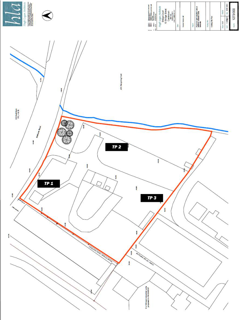
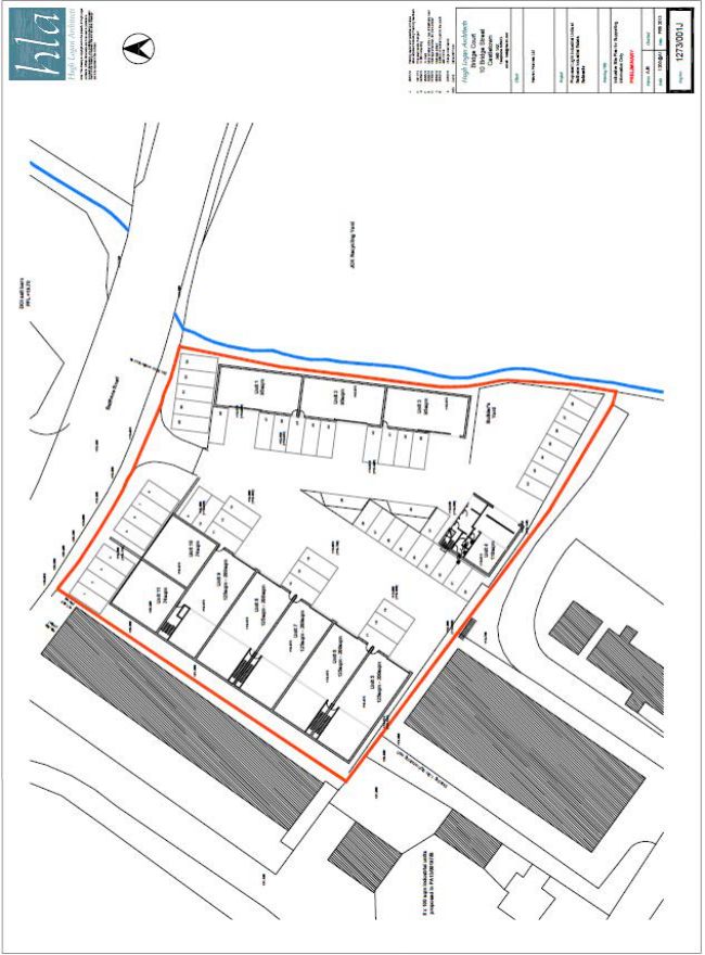
Proposed Site Layout
.
Report cTas/ 1665/15 Gas of Gas Store, Balthane Page 7 of 15
| Depth metres | Level Samples | Thickness metres | Description of Strata | Depth |
|---|---|---|---|---|
| Ground Level 0.65 | 0.65 | Grassed top soil, loamy Sand with a little coarse to fine angular gravel Made Ground | 0.65 | |
| 0.70 | 0.05 | Loose brown medium - fine Sand | 0.70 | |
| 1.70 | 1.00 | Dense dark brown loamy coarse - fine angular Gravel with some cobbles Made Ground | 1.70 | |
| 1.80 | Large boulder or bedrock | 1.80 | ||
| End of Hole |
| Depth metres | Level<br><br>Samples | Thickness metres | Description of Strata | Depth |
|---|---|---|---|---|
| Ground Level 0.65 | 0.65 | Grassed top soil, loamy Sand with a little coarse to fine angular gravel<br><br>Made Ground | 0.65 | |
| 0.70 | 0.05 | Loose brown medium - fine Sand | 0.70 | |
| 1.70 | 1.00 | Dense dark drown loamy coarse - fine angular Gravel with some cobbles<br><br>Made Ground | 1.70 | |
| 1.80 | Large boulder or bedrock | 1.80 | ||
| End of Hole |
Log not to scale Hole remained DRY during excavation.
| Depth metres | Level Samples | Thickness metres | Description of Strata | Depth Metres |
|---|---|---|---|---|
| GL 0.50 | 0.500 | Grassed top soil, loamy Sand with a little coarse to fine angular gravel Made Ground | 0.50 | |
| 0.80 | CBR 7% | 0.600 | Firm brown/gray fine sandy Silt with coarse to fine angular to sub-rounded gravel | 1.10 |
| 1.10 | ||||
| 2.30 | 1.400 | Soft gray fine sandy Silt with a little coarse to fine rounded to sub-rounded gravel With soft gray Clay lenses 20 to 50mm thick Becomes Damp at 2.30 m | 2.50 | |
| 2.50 | ||||
| End of hole |
| Depth metres | Level<br><br>Samples | Thickness metres | Description of Strata | Depth Metres |
|---|---|---|---|---|
| GL<br><br>0.50 | 0.500 | Grassed top soil, loamy Sand with a little coarse to fine angular gravel<br><br>Made Ground | 0.50 | |
| 0.80<br><br>1.10 | CBR 7% | 0.600 | Firm brown/gray fine sandy Silt with coarse to fine angular to sub-rounded gravel | 1.10 |
| 2.30 2.50 | 1.400 | Soft gray fine sandy Silt with a little coarse to fine rounded to sub-rounded gravel With soft gray Clay lenses 20 to 50mm thick<br><br>Becomes Damp at 2.30 m | 2.50 | |
| End of hole |
Log not to scale Hole remained DRY during excavation. Water level observations while hole left open Time Depth ‘0958 Damp ‘1021 2.35 m ‘1030 2.35 m
| Depth metres | Level Samples | Thickness metres | Description of Strata | Depth metres |
|---|---|---|---|---|
| GL | Loose medium to coarse rounded to sub-rounded gravels over lying Firm brown clayey Sand and Gravel with a trace of cobbles Made Ground | |||
| 0.55 | D5482 | |||
| 0.90 | D5483 CBR 10% | 2.100 | ||
| 2.10 | D5484 | 2.10 | ||
| End of hole Large boulder or Bed rock (Red Sandstone) |
| Depth metres | Level<br><br>Samples | Thickness metres | Description of Strata | Depth metres |
|---|---|---|---|---|
| GL 0.55<br><br>0.90<br><br>2.10 | D5482<br>D5483 CBR 10%<br>D5484<br> | 2.100 | Loose medium to coarse rounded to subrounded gravels over lying Firm brown clayey Sand and Gravel with a trace of cobbles<br><br>Made Ground | 2.10 |
| End of hole Large boulder or Bed rock<br><br>(Red Sandstone) |
Log not to scale Hole remained DRY during excavation
Chemical Analysis of Sample D5483
| pH | 7.33 | @25oC | |
|---|---|---|---|
| Conductivity | 58.8 | @25oC | |
| Dissolved oxygen | O | 8.09 | Mg/l |
| Oxygen saturation | O | 95 | % |
| Chemical oxygen demand | O | 13 | Mg/l |
| Alkalinity | HCO3 | 12.8 | Mg/l |
| Hardness | CaCO3 | 17.4 | Mg/l |
| Sodium | Na | 4.57 | Mg/l |
| Potassium | K | < 0.50 | Mg/l |
| Magnesium | Mg | 0.66 | Mg/l |
| Calcium | Ca | 5.87 | Mg/l |
| Ammonium | NH4 | 0.025 | Mg/l |
| Chloride | Cl | 2.94 | Mg/l |
| Nitrite | NO2 | < 0.05 | Mg/l |
| Nitrate | NO3 | 7.76 | Mg/l |
| Phosphate | PO4 | < 0.07 | Mg/l |
| Sulphate | SO4 | 5.16 | Mg/l |
| Lead | Pb | < 5 | µg/l |
| Copper | Cu | < 20 | µg/l |
| Zinc | Zn | 53.5 | µg/l |
| Iron | Fe | < 20 | µg/l |
| Manganese | Mn | < 5 | µg/l |
| Cadmium | Cd | < 0.5 | µg/l |
| Chronium | Cr | < 5 | µg/l |
| Nickel | Ni | < 5 | µg/l |
NB: All results none accredited, done on a water extract 1:10 ratio
| pH | 7.33 | @25°C | |
| Conductivity | 58.8 | @25°C | |
| Dissolved oxygen | O | 8.09 | Mg/l |
| Oxygen saturation | O | 95 | % |
| Chemical oxygen demand | O | 13 | Mg/l |
| Alkalinity | HCO3 | 12.8 | Mg/l |
| Hardness | CaCO3 | 17.4 | Mg/l |
| Sodium | Na | 4.57 | Mg/l |
| Potassium | K | < 0.50 | Mg/l |
| Magnesium | Mg | 0.66 | Mg/l |
| Calcium | Ca | 5.87 | Mg/l |
| Ammonium | NH4 | 0.025 | Mg/l |
| Chloride | Cl | 2.94 | Mg/l |
| Nitrite | NO2 | < 0.05 | Mg/l |
| Nitrate | NO3 | 7.76 | Mg/l |
| Phosphate | PO4 | < 0.07 | Mg/l |
| Sulphate | SO4 | 5.16 | Mg/l |
| Lead | Pb | < 5 | μg/l |
| Copper | Cu | < 20 | μg/l |
| Zinc | Zn | 53.5 | μg/l |
| Iron | Fe | < 20 | μg/l |
| Manganese | Mn | < 5 | μg/l |
| Cadmium | Cd | < 0.5 | μg/l |
| Chronium | Cr | < 5 | μg/l |
| Nickel | Ni | < 5 | μg/l |
Chemical Analysis of Sample D5482
| pH | 7.84 | @25oC | |
|---|---|---|---|
| Conductivity | 99.5 | @25oC | |
| Dissolved oxygen | O | 7.81 | Mg/l |
| Oxygen saturation | O | 91 | % |
| Chemical oxygen demand | O | 28 | Mg/l |
| Alkalinity | HCO3 | 27.1 | Mg/l |
| Hardness | CaCO3 | 34.6 | Mg/l |
| Sodium | Na | 9.95 | Mg/l |
| Potassium | K | 1.43 | Mg/l |
| Magnesium | Mg | 1.59 | Mg/l |
| Calcium | Ca | 11.2 | Mg/l |
| Ammonium | NH4 | 0.102 | Mg/l |
| Chloride | Cl | 3.49 | Mg/l |
| Nitrite | NO2 | 0.12 | Mg/l |
| Nitrate | NO3 | 7.12 | Mg/l |
| Phosphate | PO4 | 0.19 | Mg/l |
| Sulphate | SO4 | 9.35 | Mg/l |
| Lead | Pb | < 5 | µg/l |
| Copper | Cu | < 20 | µg/l |
| Zinc | Zn | 70.2 | µg/l |
| Iron | Fe | 124 | µg/l |
| Manganese | Mn | 8.3 | µg/l |
| Cadmium | Cd | < 0.5 | µg/l |
| Chronium | Cr | < 5 | µg/l |
| Nickel | Ni | 5.3 | µg/l |
NB: All results none accredited, done on a water extract 1:10 ratio
| pH | 7.84 | @25°C | |
| Conductivity | 99.5 | @25°C | |
| Dissolved oxygen | O | 7.81 | Mg/l |
| Oxygen saturation | O | 91 | % |
| Chemical oxygen demand | O | 28 | Mg/l |
| Alkalinity | HCO3 | 27.1 | Mg/l |
| Hardness | CaCO3 | 34.6 | Mg/l |
| Sodium | Na | 9.95 | Mg/l |
| Potassium | K | 1.43 | Mg/l |
| Magnesium | Mg | 1.59 | Mg/l |
| Calcium | Ca | 11.2 | Mg/l |
| Ammonium | NH4 | 0.102 | Mg/l |
| Chloride | Cl | 3.49 | Mg/l |
| Nitrite | NO2 | 0.12 | Mg/l |
| Nitrate | NO3 | 7.12 | Mg/l |
| Phosphate | PO4 | 0.19 | Mg/l |
| Sulphate | SO4 | 9.35 | Mg/l |
| Lead | Pb | < 5 | μg/l |
| Copper | Cu | < 20 | μg/l |
| Zinc | Zn | 70.2 | μg/l |
| Iron | Fe | 124 | μg/l |
| Manganese | Mn | 8.3 | μg/l |
| Cadmium | Cd | < 0.5 | μg/l |
| Chronium | Cr | < 5 | μg/l |
| Nickel | Ni | 5.3 | μg/l |
Ordnance Survey map - Sheet SC26NE
Proposed Site
Date of map: 1975 Scale 1:10560
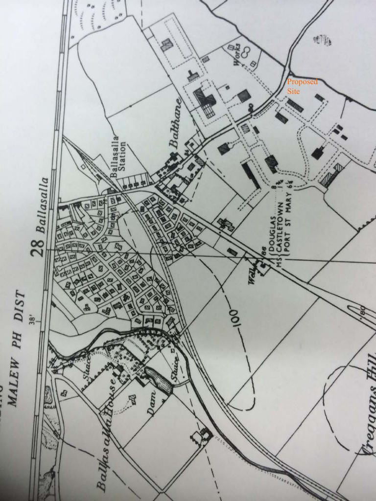
Ordnance Survey map - SC2869
Proposed Site
Date of Map 1968 Scale 1:2500
Report cTas/ 1665/15 Gas of Gas Store, Balthane Page 14 of 15
Ordnance Survey map - Malew XVI.8 Sheet 166 Date of map 1868/9 Scale 1:2500 Report cTas/ 1665/15 Gas of Gas Store, Balthane Page 15 of 15
| TBC |
|---|
Former Gas Storage Facility, Balthane Road, Balthane Industrial Estate, Ballasalla, Isle Of Man IM9 2AG
No alterations to the watercourse are proposed
Previous consultation with DEFA has resulted in a proposal to divert surface water from the site into the watercourse. A petrol interceptor was agreed to be incorporated to prevent pollutants from entering the watercourse.
Not known at present and subject to obtention of statutory approvals.
These materials are required throughout the development. Waste materials will be disposed of in skips, allocated specifically for this purpose, for removal from the site. All mixing works are to be untertaken far away from the watercourse.
All hazardous liquid products will be appropriately contained. These containers will be disposed of in skips, allocated specifically for this purpose, for removal from the site.
Washings of plant and cement mixers will be carried out on concrete wash-down areas allocated specifically for this purpose. Washings will be left to cure and will be disposed of in skips, for removal from the site.
The bank of the watercourse will be protected during works to prevent any such material from entering the watercourse.
All operatives will be educated of the risks when they are inducted onto site, prior to the commencement of construction works.
JAMES QUAYLE 01624 835222
EUAN CRAINE
Haven Homes c/o Mr James Quayle The Old Chapel Malew Street Castletown IM9 1AF
In exercise of the powers conferred by section 5 of the Tree Preservation Act 1993 the Department of Environment, Food and Agriculture hereby grant to you licence to undertake the work specified in the schedule below. The work authorised by this licence shall be carried out as detailed in your application and as qualified by the conditions set out below.
This licence expires at the end of 2 years beginning with the date specified below and the authorised work shall not be carried out more than once within this time, unless authorised by a further grant of licence.
Location of trees: Balthane Industrial Estate, Balthane, Ballasalla, IM9 2AG
Conditions (failure to comply is an offence under the Act):
Date: 18 September 2019 Head of Forestry, Amenity & Lands Page 1 of 2
| Species | Number of Trees | Registered Y/N | Authorised Work |
|---|---|---|---|
| Sycamore | 1 | N | Felling |
| Whitebeam | 4 | N | Felling |
Copyright in submitted documents remains with their authors. Request removal