Planning Statement In Respect Of The Development Of A Cafe, Recreation And Community Facility (Class 1.3 (Cafe), Class 1.4 (Take Away Food) And Class 4.3 (Other Community Facilities), Tennis Courts, Marine Parade, Peel
1.0 Introduction
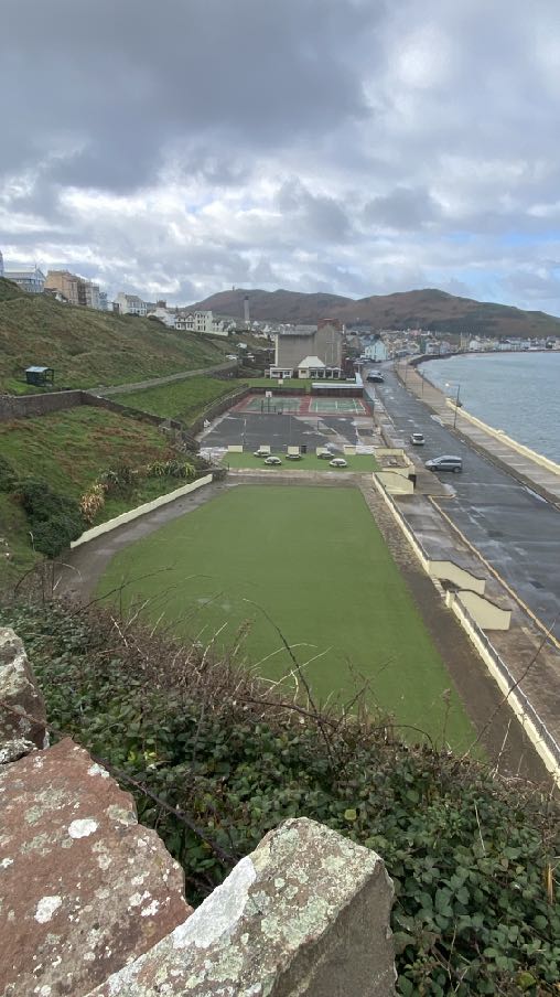
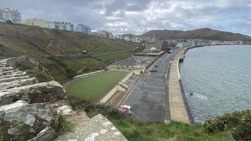
1.1 The site is an area of two public tennis courts situated on the south eastern side of Marine Parade at the north eastern end of Peel’s promenade (Shore Road). The site has a frontage of approximately 35m and a depth - front to back - of 29m - an area of 1,015 sq m. The tennis courts sit within a wider area of land and community facilities owned by Peel Town Commissioners: to the south west is the existing cafe, bowling green, public toilet block and club house and to the north east is a hard surfaced, multi sport area incorporating basketball nets and formerly a skateboard/BMX park: beyond that, the former swimming pool which is now an artificial grassed area with picnic tables and chairs. This overall area amounts to approximately 8,734 sq m all within the ownership and management of the local authority with a further 27,550 sq m of brooghs and play area to the south and east, all accessible by public paths which wind along the brooghs and step down across the site and abut the swimming pool, multi sport area court and bowling green.
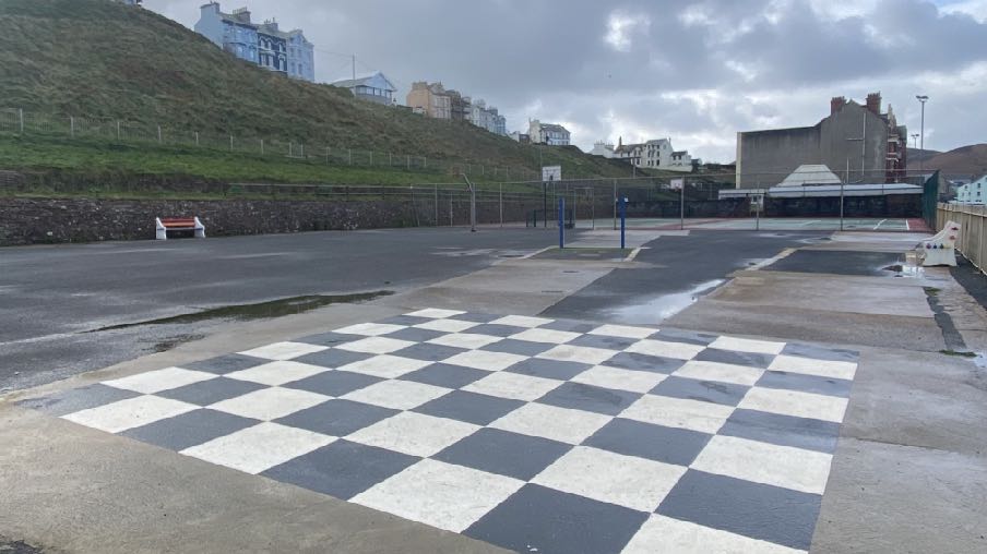
1.2 The site presently accommodates two hard surfaced tennis courts which have higher boundary fencing alongside the highway. Both the tennis courts and the multi sport area back onto a grassed lane on top of a sandstone wall at the rear which provides access to the bowling green which sits alongside the tennis courts. The tennis courts currently have no nets which are erected every year around May and removed at the end of the summer. The skatepark jumps which were introduced in 2010 have been removed due to their poor condition (rusting). To the north east is a flat artificial grassed area where there are benches and tables.
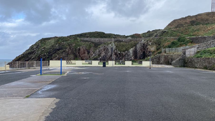
Former skateboard/BMX park and basketball court
Tennis court area
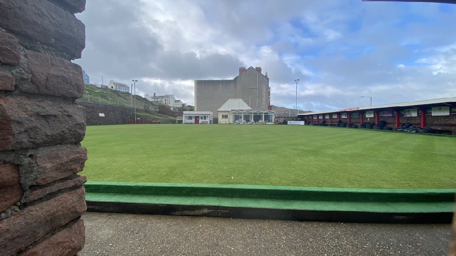
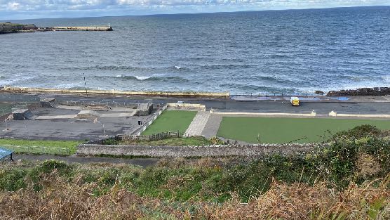
Bowling green with cafe, public toilet block and clubhouse in the background
A photograph showing a large bowling green with a long clubhouse building on the right and a stone wall in the foreground.
Artificial grass and picnic tables and chairs at the north eastern end of the promenade
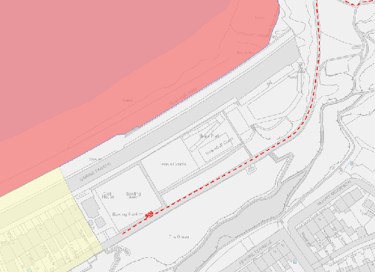
1.3 Public access runs through the wider site (PROW 506 - Walpole Road to the Headland
the red dotted line on the plan right which runs between the multi sport area and the artificial grassed area) and to the broogh area to the south which rises to join Peveril Terrace and Mount Morrison which sit 79m from the nearest point of the site and considerably higher.
A site location map showing property boundaries, roads, and surrounding land use zones with colored areas.
1.4 The pink area in Peel Bay on the above map denotes the West Coast Marine Nature Reserve and the yellow area the north eastern extent of the adopted Peel Conservation Area.
1.5 The site and surrounding area is owned and managed by Peel Town Commissioners who advise that the tennis courts are not well used, mainly in Wimbledon week, and it is their long standing view that the site is underused and should a better use be found for it, they would relocate the existing facilities - the tennis courts and multi sport area - to another, more central and accessible part of the town.
1.6 The Commissioners have invested heavily in the Swimming Pool and Campsite areas on Derby Road and have made representations to the Area Plan for the North and West to have the remaining undeveloped land adjacent to Ballaquane Road re-designated as Public Open Space to replace that which could be lost as a result of the expansion of the Peel Clothworkers’ School which will support the growth of the town. They are also looking to expand the playground facilities at West View and leisure use on the Headlands Field.
1.7 They advise that the skate park required major refurbishment and one of the pieces of equipment was fenced off in 2022 to prevent its use and it and the other jumps have since been removed and the Commissioners are considering relocating this facility to a less exposed location.
2.0 The proposal
2.1 Proposed is the principle of the relocation of the existing cafe, clubhouse and public toilets to the site of the current tennis courts and incorporating an indoor community facility incorporating a club room, function room and potential indoor bowling lanes. The public toilets (male, female and accessible) will incorporate external access to permit use whilst the cafe and the rest of the building are not in use
2.2 The existing cafe to the south west of the bowling green is very popular but not in a good state of repair and it is intended that this current proposal will provide an alternative cafe location whilst works are undertaken on that site with the intention that it would be repurposed for use in association with the bowling green to provide additional facilities as well as the public toilet block which is also past its useful life.
2.3 The application is in principle only and illustrative images have been provided to demonstrate how the development could be delivered. The area is characterised by several linear sandstone walls which run horizontally alongside Marine Parade - low walling alongside the tennis courts and basketball/ skateboard courts but higher walling alongside the bowling green - as well as at the base of the brooghs and in front of Peveril Terrace.
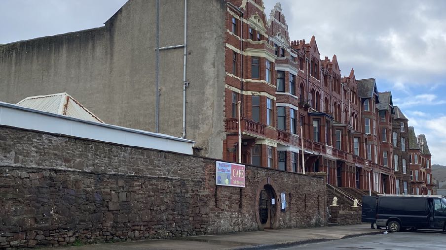
Roadside walling to the bowling green and entrance to the cafe and clubhouse
A street-level photograph showing a row of red brick terraced buildings next to a large concrete structure, separated by a stone wall with a cafe sign.
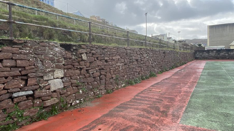
Sandstone wall to the rear of the tennis courts (above) View across the skate/BMX park and basketball court towards the sandstone rocks and wall to the side of the coastal path (below)
2.4 The illustrations which are included for consideration, show a modern building which acknowledges these linear features and incorporates a strong sandstone wall frontage with a potentially glazed cafe building in front with a paved external seating and circulation area. The lean-to roof of the building to the rear of the sandstone wall could be finished in a green roof to visually merge with the brooghs to the rear, as viewed from the higher perspective behind, either from the rear footpath, the brooghs or the residential properties in Victoria Terrace, Peveril Terrace and Mount Morrison.
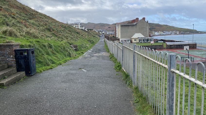
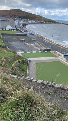
A photograph showing a paved pathway running alongside a grassy slope and a metal fence, with a sports court and large building visible in the background near the coast.A high-angle photograph showing a coastal site in Peel, featuring old stone ruins in the foreground, a bowling green, a parking area, and a sea wall along the promenade.
2.5 Access would be from Marine Parade, with a small set of steps and a ramped alternative directly from the footway. Deliveries would also be from this access although there is also a vehicular access at the rear if required albeit at a higher level which is currently accessed via a set of steps from the basketball court.
2.6 Provision could be made for the relocation of one of the tennis courts onto the multi sport area as shown in the proposed site plan.
2.7 The facilities would be accessible to anyone visiting this end of the promenade and/or using whatever facilities there are in this are of publicly owned land.
A photograph showing a paved pathway running alongside a grassy bank and metal fence, leading towards a coastal bowling facility and the sea.
3.0 Planning status Peel Local Plan
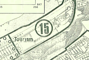
3.1 The site lies within an area designated on the Peel Local Plan of 1989 as Tourism:
3.2 The site lies outside of the town’s Conservation Area which ends just before the bowling green. There are no buildings - Registered or otherwise - on the site, nor trees - Registered or otherwise and the site is not at risk of flooding according to the national flood risk maps.
3.3 The Written Statement accompanying the Peel Local Plan map refers specifically to this site, stating, “Part of the Marine Parade Area has already been approved for hotel use and some of the adjoining open space will be required to complete the development.”
3.4 The Plan identifies the “principal open space areas” as Peel Hill, the Headlands and former bowling green, putting green and miniature golf course, the eastern coastal area bounded by Ramsey Road and the camp site on Derby Road and there is a general statement at paragraph 13.2 that open space areas within the town will generally be safeguarded from development, particularly identifying Peel Hill for such protection as well as the eastern coastal area bounded by the Ramsey Road.
3.5 Under “Tourism and Transport” it simply states: “It should be noted that an approval exists for a hotel development on the site of the swimming pool on the East of Marine Parade”.
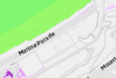
A black and white map extract showing the application site marked with a large number 15 and the label 'Tourism'.A map extract showing the road 'Marine Parade' with building outlines and land boundaries.
3.6 It also notes that it was anticipated at the time that tourism will become increasingly important to the economy of Peel and will exert pressure on the fabric of the town but that it is essential that the integrity of the town is retained and that any such development is sympathetic to and compatible with the overall environment of the town (paragraphs 4.11 and 4.12).
Isle of Man Strategic Plan 2016
3.7 The starting point in the assessment of any planning application is the land use designation in the adopted local or area plan. If the development is in accordance with that designation, which this is, the Strategic Plan, General Policy 2 is applicable, stating:
“Development which is in accordance with the land-use zoning and proposals in the appropriate Area Plan and with other policies of this Strategic Plan will normally be permitted, provided that the development:
(a) is in accordance with the design brief in the Area Plan where there is such a brief;
(b) respects the site and surroundings in terms of the siting, layout, scale, form, design and landscaping of buildings and the spaces around them;
(c) does not affect adversely the character of the surrounding landscape or townscape;
(d) does not adversely affect the protected wildlife or locally important habitats on the site or adjacent land, including water courses;
(e) does not affect adversely public views of the sea;
(f) incorporates where possible existing topography and landscape features, particularly trees and sod banks;
(g) does not affect adversely the amenity of local residents or the character of the locality;
(h) provides satisfactory amenity standards in itself, including where appropriate safe and convenient access for all highway users, together with adequate parking, servicing and manoeuvring space;
(i) does not have an unacceptable effect on road safety or traffic flows on the local highways;
(j) can be provided with all necessary services;
(k) does not prejudice the use or development of adjoining land in accordance with the appropriate Area Plan;
(l) is not on contaminated land or subject to unreasonable risk of erosion or flooding;
(m) takes account of community and personal safety and security in the design of buildings and the spaces around them; and
(n) is designed having due regard to best practice in reducing energy consumption.”
3.8 Other policies encourage the optimal use of undeveloped and under-developed sites and the promotion of sustainable development (see Appendix One).
3.9 Whilst the site is not within a Conservation Area, it is close to it so Environment Policy 36 is applicable:
“Environment Policy 36: Where development is proposed outside of, but close to, the boundary of a Conservation Area, this will only be permitted where it will not detrimentally affect important views into and out of the Conservation Area.”
3.10 Environment Policy 43 explains that the Department will generally support proposals which seek to regenerate run-down urban and rural areas. Such proposals will normally be set in the context of regeneration strategies identified in the associated Area Plans. The Department will encourage the reuse of sound built fabric, rather than its demolition. This echoes Strategic Policy 1 which encourages the optimisation of the use of unused and under-used land.
3.11 The Tourism Chapter explains that the Strategic Plan supports the growth of employment opportunities (Business Policy 1), and explains that some tourism facilities do not require permanent development and explains that a balance needs to be struck between the needs of tourism and the protection of the very assets which attract tourists to the Island in the first place - its unique landscape, culture and heritage. It welcomes “new forms of contemporary tourism development” (paragraph 9.5.5) and that it is more likely than the traditional Victorian hotel, that tourist accommodation demands are met through the designation of specific tourist attractions and large individual hotel sites with “new tourist accommodation incorporated into areas of mixed or residential use”.
3.12 Chapter 10 of the Strategic Plan sets out the acknowledged importance and benefit of open space and leisure and recreation facilities, recommending that area plans assess the needs of the plan area in terms of sport and recreation and identify land uses in accordance with those findings. It also states:
“10.3.5 In certain circumstances it may be beneficial to allow the redevelopment of areas of underused, poorly maintained or inappropriately located open space. Development on such areas will only be permitted where alternative provision can be made. However, the new open space must be easily accessible to the local community and be at least equivalent in terms of type, quantity and quality to that which is being replaced.
Recreation Policy 2: Development which would adversely affect, or result in the loss of Open Space or a recreation facility that is or has the potential to be, of recreational or
amenity value to the community will not be permitted except in the following circumstances:
(a) where alternative provision of equivalent community benefit and of equivalent or better accessibility is made available; and
(b) where there would be an overall community gain from the development,
and the particular loss of the open space or recreation facility would have no significant unacceptable effect on local open space or recreation provision or on the character or amenity of the area.”
3.13 The only definition of Open Space that we have been able to find is that within the Isle of Man Planning Scheme (Development Plan) Order 1982 Written Statement where it states that this is “any land, whether enclosed or not, on which there are no buildings or on which not more than one twentieth part is covered with buildings”.
3.14 The Strategic Plan sets out standards for the provision of car parking, suggesting that in the case of town centre retail use (there are no specific standards for cafes), spaces should be provided for service vehicle use and for assembly and leisure, one space per 15 sq m gross floor area should be provided, although this standard may be relaxed where development
“(a) would secure the re-use of a Registered Building or a building of architectural or historic interest; or
(b) would result in the preservation of a sensitive streetscape; or
(c) is otherwise of benefit to the character of a Conservation Area.
(d) is within a reasonable distance of an existing or proposed bus route and it can be demonstrated a reduced level of parking will not result in unacceptable on street parking in the locality.”
(Transport Policy 7 and Appendix Seven).
Area Plan for the North and West
3.15 This is in preliminary stages only with a Call for Sites having been made by Cabinet Office after which a draft plan was published for comment and responses received. This was published in June 2022 although nothing has been published since despite the draft plan suggesting that it would be the subject of a public inquiry in the using of 2023.
3.16 The plan which defines the settlement boundaries at this stage shows the site being within Peel’s settlement boundary. It designates the area presently shown as Tourism, as Open Space which is part of the wider area of Open Space incorporating the brooghs to the rear and the headlands and play
area to the east. The Written Statement which accompanies this includes the following Proposal specifically applying to this site and surrounding area:
Open Space and Community Proposal 2: Site PO007 on the northern end of Peel Promenade is recognised as important recreation and leisure space. Opportunities to enhance these facilities or introduce new compatible uses that would not detract from the primary use of the site for recreation and leisure space will be considered on their merits, taking into account overall scale, design and layout, traffic generation and other planning considerations.
3.17 Due to the preliminary nature of the draft Area Plan, it should have little or no weight in decision making at the present time albeit that it demonstrates Cabinet Office’s thinking in respect of how Peel and this part of the Island should be evolving.
3.18 This document reiterates Peel’s place in the settlement hierarchy as a Service Centre where development will be concentrated outside Douglas.
4.0 Planning history
4.1 Planning approval was granted in principle for the development of the site for a hotel under 88/01268/A and 87/00096/A which followed an earlier application for the principle of a hotel/ conference/leisure complex which was refused on appeal having been approved on review (87/01100/A).
4.2 The Marine Hall which formerly existed on the north eastern part of the site was approved for use for pilot training under 86/01277/C. Permission was granted for the principle of a multi-use civic hall and recreational community facility to replace the hall under 11/00112/A.
4.3 None of the above applications was implemented nor reserved matters applications submitted.
4.4 The most recent application on the site which was approved on appeal was for the principle of a hotel leisure complex, residential apartments and parking spaces (05/01277/A) granted on 31.10.06. The inspector was not persuaded that there was sufficient information contained within the application to demonstrate that the development would be acceptable but the Minister determining the appeal was and the application was approved. No reserved matters application was submitted following this approval.
4.5 More recently an application was submitted for the development of a temporary tourist village on the site although this application was withdrawn prior to a decision being taken (21/01537/B).
4.6 The most recent application for the area was one of the additional use of the former swimming pool site (Class 1.3 Food and drink) as a pop-up lounge bar for 32 operating days from Fri 4th Aug Sun 3rd Sept with one week before installation from Fri 28th July to the opening on Fri 4th August and one-week de-rig from Monday 4th Sept to Monday 11th Sept. This was permitted. The Planning Officer in his assessment of the application noted, “A concern is the temporary loss of the public open space area and what that might mean for the wider public. Given its temporary nature and in referencing to Recreation policy 2, this makes allowances through (b) where there is a community gain from the development, and the particular loss of the open space would have no significant unacceptable effect on the character or amenity of the area” and also notes that the site would still be available for the public to use whilst the proposed use was undertaken.
5.0 Assessment
5.1 The starting point of any assessment is the land use designation in the adopted development plan. In this case this is the Peel Local Plan which designated the site as for Tourism and noting the previous approvals for the development of a hotel. Indeed there was since a further approval granted for this type of development although the Strategic Plan was not at that time, adopted so Recreation Policy 2 would not have been tested.
5.2 No planning approval was sought or granted for the installation of the ramps and jumps formerly on the skate/BMX park and the established use of the site is through historic use as a miniature golf facility, tennis courts, basketball court and swimming pool. It is relevant that formerly there was a community hall building on the site and its re-introduction was approved in 2011.
5.3 Notwithstanding the current use and historic use of the site for leisure and recreation purposes, the site is designated for Tourism on the only adopted plan for the site, and planning approval has been granted variously since 1987 for tourist accommodation on this site. As such, the principle of the development of this site for built structures should remain acceptable if the use of those buildings is compatible with the land use designation.
5.4 Whilst the Strategic Plan through Recreation Policy 2 presumes against the loss of recreation space, it is clear that this is not universally applied and that this presumption only applies to space which “is or has the potential to be, of recreational or amenity value to the community”. Therefore, if it can be demonstrated that the tennis courts are not of recreational or amenity value to the community then this policy would not effectively justify refusal of the application for the development of the site for other purposes.
5.5 Peel Town Commissioners would submit that the tennis courts are not well used: it is also clear from an inspection of the site that the facilities have not been maintained and in fact the tennis courts do not have nets for most of the year, leading to this area being underused. If it is deemed appropriate to have tennis courts in this location one could be relocated to the current multi sport area alongside as shown in the proposed site plan. The Commissioners have found that the most popular sports facilities are those which offer a range of sports rather than one dedicated facility, particularly those which attract seasonal use, such as tennis.
5.6 It is also considered relevant that the owners, who are responsible for the management of most of the Public Open Space in the town, are willing to have the site used for other purposes and consider that the tennis courts would be better used as a community facility which will offer both new recreation facilities, indoor community space and a modern cafe all of which could be used by locals and visitors alike and maintaining an interest in this end of the promenade.
5.7 The pre-amble to the recreation policy and the policy itself also require that the facilities to be lost should be provided elsewhere. In previous applications it was stated by the Commissioners that they would relocate the recreation facilities on the headlands should those developments have been implemented and their most recent advice talks of a site which is less exposed that Marine Parade. As stated previously, the Commissioners are very keen to establish a more central and less exposed recreation and community area off Derby Road next to the swimming pool and publicly operated camp site. There is opportunity for the tennis courts to be lost as part of this development could be recreated alongside where the former basketball court and former skate/BMX park were sited.
5.8 The development is considered to comply with General Policy 2 - notably the potential design and appearance of the development has been designed to reflect the dominant landscape features whilst remaining unobtrusive in the wider streetscene.
5.9 The proposal will replace the existing cafe facility so that element of the development will not generate greatly different traffic and parking requirements to the existing situation. There is significant parking on Marine Parade, at right angles to the footways and including accessible spaces for disabled users. Similarly, the new recreation facilities are likely to be associated with the existing bowling green and should not generate significantly greater traffic or parking requirements. The introduction of community facilities would be a new use on this site albeit that in the past there was a community hall in this area and indeed a re-introduction of this facility approved in 2011, but the floor space involved is not significant and the resulting traffic and parking not likely to be such as to cause an issue for the surrounding area where there is on street parking available to serve the existing and any future recreation facilities and footpaths in this general area. The site is also within convenient walking distance of public transport and a signifiant part of the town’s population.
5.10 The proposed building will be seen not only from the road in front, from the rear and side where there are public footpaths and also from above so the appearance and particularly the finish of the rear roof will be important. The proximity to the Conservation Area also brings a requirement for the development to sit comfortably in the streetscene and landscape. It is proposed to utilise green roofing so that from the rear, the building will visually merge into the brooghs which sit behind it.
Views from the upper brooghs in 2022
5.11 The site is accessible and sustainable but currently contributes little to the visual character or functionality of the area. It is submitted that the proposal will maintain a well used cafe facility at this end of the promenade whilst also introducing new community and recreational uses which would accord with the emerging Area Plan whilst also providing facilities for tourists which would accord with the existing adopted local plan.
6.0 Conclusion
6.1 It is considered that this proposed development will regenerate this part of the promenade, improving the appearance of the site and resulting in the site being better used by locals and visitors alike, complementing the range of amenities and facilities available further along the promenade.
6.2 The proposal is considered to be consistent with both the adopted local plan and what is envisaged in the emerging area plan. The proposal is considered to satisfy or accord with General Policy 2, Strategic Policy 1, Environment Policies 36, 42 and 43, Transport Policies 4 and 7.
Sarah Corlett 16th November, 2023
APPENDICES
Appendix One - Strategic Plan Policies Strategic Aim: To plan for the efficient and effective provision of services and infrastructure and to direct and control development and the use of land to meet the community’s needs, having particular regard to the principles of sustainability whilst at the same time preserving, protecting, and improving the quality of the environment, having particular regard to our uniquely Manx natural, wildlife, cultural and built heritage.
Strategic Policy 1: Development should make the best use of resources by:
(a) optimising the use of previously developed land, redundant buildings, unused and under-used land and buildings, and reusing scarce indigenous building materials;
(b) ensuring efficient use of sites, taking into account the needs for access, landscaping, open space and amenity standards; and
(c) being located so as to utilise existing and planned infrastructure, facilities and services.
Strategic Policy 2: New development will be located primarily within our existing towns and villages, or, where appropriate, in sustainable urban extensions of these towns and villages. Development will be permitted in the countryside only in the exceptional circumstances identified in paragraph 6.3.
Strategic Policy 3: Proposals for development must ensure that the individual character of our towns and villages is protected or enhanced by:
(a) avoiding coalescence and maintaining adequate physical separation between settlements; and
(b) having regard in the design of new development to the use of local materials and character.
Strategic Policy 4: Proposals for development must:
(a) Protect or enhance the fabric and setting of Ancient Monuments, Registered Buildings, Conservation Areas, buildings and structures within National Heritage Areas and sites of archaeological interest;
(b) protect or enhance the landscape quality and nature conservation value of urban as well as rural areas but especially in respect to development adjacent to Areas of Special Scientific Interest and other designations; and
(c) not cause or lead to unacceptable environmental pollution or disturbance.
Strategic Policy 5: New development, including individual buildings, should be designed so as to make a positive contribution to the environment of the Island. In appropriate cases the Department will require planning applications to be supported by a Design Statement which will be required to take account of the Strategic Aim and Policies.
Strategic Policy 10: New development should be located and designed such as to promote a more integrated transport network with the aim to:
(a) minimise journeys, especially by private car;
(b) make best use of public transport;
(c) not adversely affect highway safety for all users, and
(d) encourage pedestrian movement
Spatial Policy 2: Outside Douglas development will be concentrated on the following Service Centres to provide regeneration and choice of location for housing, employment and services -Ramsey, Peel, Port Erin, Castletown, Onchan. Area Plans will define the development boundaries of such centres so as to provide a range of housing and employment opportunities at a scale appropriate to the settlement.
Spatial Policy 5: New development will be located within the defined settlements. Development will only be permitted in the countryside in accordance with General Policy 3.
Environment Policy 42: New development in existing settlements must be designed to take account of the particular character and identity, in terms of buildings and landscape features of the immediate locality. Inappropriate backland development, and the removal of open or green spaces which contribute to the visual amenity and sense of place of a particular area will not be permitted. Those open or green spaces which are to be preserved will be identified in Area Plans.
Environment Policy 43: The Department will generally support proposals which seek to regenerate run-down urban and rural areas. Such proposals will normally be set in the context of regeneration strategies identified in the associated Area Plans. The Department will encourage the re-use of sound built fabric, rather than its demolition.
Copyright in submitted documents remains with their authors. Request removal
Source & Provenance
Official reference
23/01360/A
Source authority
Isle of Man Government Planning & Building Control