Planning Statement For The Creation Of A Car Park, Claughbane Quarry, Claughbane Plantation, Garff
1.0 Introduction
1.1 As the site is owned and managed by Department of Environment, Food and Agriculture, the application should be referred to the Council of Ministers for determination under Article 16 (1)(b) of the Town and Country Planning (Development Procedure) Order 2019.
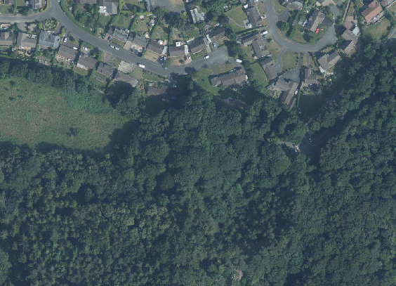
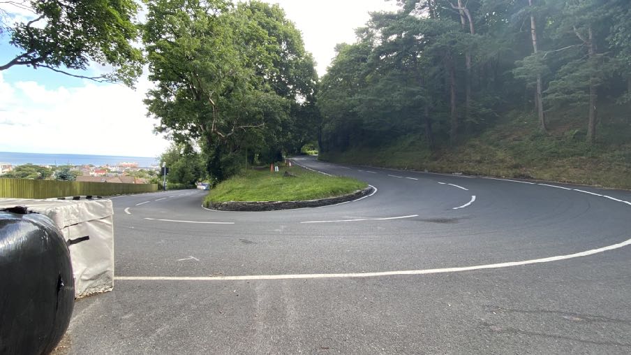
1.2 The site is a former quarry area within Claughbane Plantation which lies to the south of Ramsey and to the west of the A18 Mountain Road which is part of the TT Course. The A18 at this point rises and turns through a tight bend known as The Hairpin. The speed of traffic is restricted to 30 mph but in practice, those negotiating the bend in both directions travel significantly slower than this.
1.3 There is a wide lay-by at this point where there is a bench and frequently accommodates parked vehicles. During periods of road closures for the racing the area is not publicly accessible and over the summer between TT and Manx Grand Prix/Classic TT the area is often occupied by signage relating to the management of the Mountain Road (one way, two way) and road safety advertisements together with racing crash barriers and bales.
1.4 Visitors also park here to explore Elfin Glen, Upper Lhergy Frissell Glen, and to gain access to Public Rights of Way that allow access to Glen Auldyn (PROW 74), Ballure (PROW 502) and the Uplands (PROW 355) all of which are in close proximity to the Hairpin.
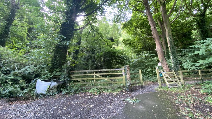
1.5 To the west of the Hairpin there is an access track which leads west along the northern perimeter of the Claughbane Plantation and with the rear of 53 - 69 (odd numbers only) and 75, Claughbane Drive along with Claughbane Lodge.
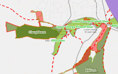
1.6 This lane is a public footpath (PROW 74) and is bounded by Registered Trees (RA1557). The plantation to the south accommodates the Hairpin Woodland Walk, an area managed as a Nature Reserve by the Manx Wildlife Trust and described by them as “Restoration of a conifer plantation into the Island’s first forest; a haven for wildlife and people alike”. The plantation, including the application site, is identified as a Designated Wildlife Site:
A planning map showing designated areas and boundaries in a rural location, specifically highlighting glens and local place names like Claughbane and Ballure.
2.0 Planning policy
2.1 Planning policy takes a number of forms: development plans set out what purpose or function land is designated for - land is designated for a particular purpose or not - and these development plans take the form of a variety of adopted Area or Local Plans (or where there is neither, Isle of Man Planning Scheme (Development Plan) Order 1982). Above this, there is the Isle of Man Strategic Plan 2016 which is not geographic but provides over-arching strategic policies which apply across the Island. Area Plans should be in general conformity with the Strategic Plan but where there is any contradiction or conflict, whichever was adopted later would prevail (paragraph 1.4.4).
2.2 Consideration can also be given in the determination of any planning application, to Planning Policy Statements, Planning Circulars, National Policy Directives (there is none as yet) or other statements of planning policy as well as other Government policies. Planning is a balance of all of these considerations as well as anything else which could be considered a material consideration.
Isle of Man Planning Scheme (Development Plan) Order 1982
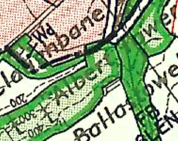
2.3 The site lies outwith the boundary of the Ramsey Local Plan which was adopted in 1998. As such, the adopted development plan for the site is the Isle of Man Planning Scheme (Development Plan) Order 1982 which designates the site as a “plantation owned by the Isle of Man Forestry, Mines and Lands Board”. It is not within an area of an area of High Landscape or Coastal Value and Scenic Significance. This Government Department is now Department of Environment, Food and Agriculture and specifically the Agriculture and Lands Directorate/Forestry, Amenity and Lands Division.
Close-up view of a site map showing field boundaries, green shading for vegetation, and text labels.
2.4 Cabinet Office commenced the preparation of an Area Plan for the North and West of the Island which would have included this site and superseded all of the extant development plans in this area. The plan commenced as far as a draft Area Plan but despite the document setting out the timescale for the adoption of the plan by Tynwald, with a public inquiry to be held in the Spring of 2023, no further developments have emerged and no date fixed for the public inquiry.
2.5 Notwithstanding this lack of progress, the plan contains some interesting background information which is relevant to the consideration of this application. In particular, the draft plan has a series of other maps which highlight constraints such as ecological sensitivity, conservation areas, areas liable to flood and registered trees. The Environmental Constraints map shows the area as partly “Plantation” (green outline with tree images) and of ecological importance (brown hatching).
2.6 On the Infrastructural Constraints there are no constraints identified.
2.7 The site lies within an area which is not designated for development. In such areas there is a general presumption against development, as set out in General Policy 3 of the Strategic Plan (see Appendix One). Environment Policies 1 and 2 presume against development which would be harmful to the character and appearance of the countryside, EP 2 placing even more weight on the protection of the character and quality of the countryside in areas which were identified on the Isle of Man Planning Scheme (Development Plan) Order 1982 as of an area of High Landscape or Coastal Value and Scenic Significance: this site is not so designated, the site being designated as a ‘Plantation owned by the Isle of Man Forestry, Mines and Lands Board’ on that map.
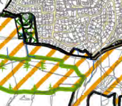
A site plan showing a specific plot outlined in black, surrounded by orange hatched zones and green areas with tree symbols, set against a background of a street grid.
2.8 Environment Policy 2 refers to the areas of high landscape value and scenic significance but these have been replaced in the Area Plan for the South with the Landscape Character Assessment designations which characterise the countryside by the type of landscape rather than by its perceived quality. The site lies within an area in this assessment of Undulating Lowland Plain - Sulby River. The full assessment of 2008 on which the Area Plan policies are based, is set out in Appendix Two. The site lies within a wider area of Sulby River Undulating Lowland Plain. The conclusion of this as it applies to the application site is as follows:
The overall strategy should be to conserve and enhance the character, quality and distinctiveness of this rural area with its scattered settlement pattern, relatively strong field pattern, a network of enclosed minor rural roads and its ecologically valuable aquatic and riparian habitats.
2.9 There is no areas of potential risk of flooding on the national flood risk maps.
2.10 There are no buildings on the site, Registered or otherwise although there is a current application for the erection of a cabin alongside (see Planning History). The site is not within a Conservation Area.
Planning policies
2.11 Whilst there is a presumption against development in this area according to General Policy 3, there is provision for “buildings or works required for interpretation of the countryside, its wildlife or heritage”. Paragraph 7.13.2 expands on this, stating that “There is, however, a general presumption against the introduction of new uses into the countryside (including industrial or office uses): (a) for which there is no local need; (b) which would materially effect the rural character of an area; (c) which would necessitate the creation of new buildings; and (d) which would be more appropriate in industrial zones, business parks or within urban centres.”
2.12 Development should not have a detrimental impact on woodlands particularly ancient, natural and semi-natural woodlands which have public amenity or conservation value (Environment Policy 3). Whilst most of the Island’s plantations were originally established as a commercial conifer timber resource, many are now being managed for amenity, wildlife and recreation purposes (hence the change of name from plantations to Forests and the MWT website refers to Claughbane Plantation as the “first forest”).).
2.13 Development should have an acceptable impact on ecology (Environment Policy 4).
2.14 Woodlands are accepted in the Strategic Plan (Appendix 6 A.6.3) as making a valuable contribution to the total recreational provision of communities, particularly those that are deficient in recreational space. The section of the Plan on Sport, Recreation, Open Space and Community Facilities also states that “10.1.1 The quality of life on the Island and the quality of our environment are improved by attractive open space and by facilities for recreation and other community purposes.”
It goes on:
10.3.2 Open Space forms part of our heritage as well as being an attractive and usable asset, and, in the wider context, provides visual and spiritual relief from the developed urban settlements on the Island. In addition, it provides recreational enjoyment in respect of various active and some less active forms of sporting activity. Open Spaces also provide a means of improving the health and fitness of the Island’s population. Open Space is defined in this context as land used for recreational purposes, both formal and informal, including amenity space whether privately or publicly owned.
10.3.3 The Strategic Plan needs to facilitate sport and recreation opportunities and to ensure that areas of open space are retained, and provided to meet local needs. The Strategic Plan will facilitate this by a three pronged approach:
a) protecting existing assets;
b) making good deficiencies in existing provision; and
c) providing adequate provision within new development.
2.13 Development which would adversely affect the environment is presumed against (Environment Policy 22):
7.17.2 In addition to the above, changes in the activities associated with the current permitted use of land or a building, which in themselves do not constitute development and therefore do not require planning permission, can have an adverse impact on adjacent properties by virtue of noise, light or general disturbance. For example the addition of security lighting on a property may cause light pollution affecting adjacent properties and the wider area. The introduction of new activities into established parks and recreation areas can have an impact on neighbours. In such cases the Department would advocate the person or organisation considering the change to give careful
consideration to the potential impact of such activity in terms of location, siting and design.
2.14 Development for the improvement of existing facilities must have regard to any potential adverse impact on those in neighbouring property (Environment Policy 23).
2.15 Plantations require maintenance and in recognition of this, there is provision within the the Town and Country Planning (Permitted Development) Order 2012 for the undertaking of certain works which outwith the plantations would require planning permission:
40 Class 40 Forestry operations The carrying out on land used for the purpose of forestry of operations reasonably necessary for that purpose and consisting of —
(a) the formation, alteration or maintenance of a private roadway, or
(b) the getting of materials required for the formation, alteration or maintenance of a private roadway.
Exception: Operations within this Class are not permitted if carried out within 25 metres of a highway.
3.0 Planning history and relevant applications
3.1 The only planning application which has been submitted for this site is a current application for the erection of an open sided timber pavilion (23/00510/B) which is currently under consideration. Like this current proposal, that application has to be referred to the Council of Ministers for determination as the land is within the ownership of Department of Environment, Food and Agriculture even though the applicant is a different party (Manx Wildlife Trust).
3.2 23/00510/B proposes the use of part of the application site insofar as it will provide pedestrian access to and from the proposed pavilion. At the current time there are only two representations: that from Garff Commissioners states that the consensus was that the proposals would provide enhancement to the visitor experience in both the glen and woods area. The Commissioners resolved to express support for the application and to recommend approval. The other representation was from the Highway Services Division of Department for Infrastructure who have no objection to the application.
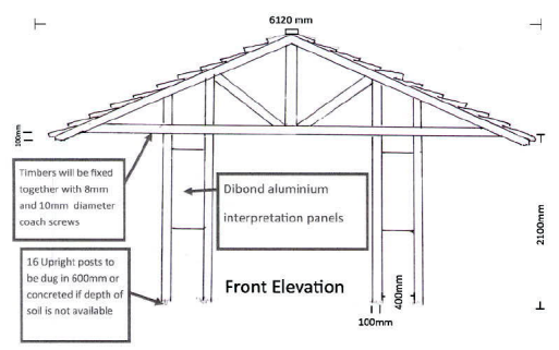
3.3 The application proposes the erection of this structure noting, “We aim to build an open sided timber pavilion (using trees felled from thinning operations on site). The pavilion will contain interpretive panels that will enable more profound public engagement with surrounding woodlands. Note while the pavilion will be built within a woodland no trees in the surrounding area will be felled or lopped.” The proposal is as follows:
A technical front elevation drawing of a timber structure featuring dimensions and construction notes for aluminium interpretation panels.
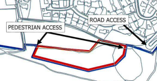
3.4 Planning approval was also sought for the creation of a children’s playground and amendments toexisting paths: this was approved in 2017:
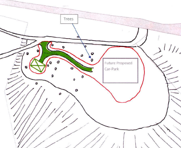
A site plan illustrating a proposed development boundary in red with arrows indicating pedestrian and road access points.A hand-drawn site plan sketch illustrating the layout for a future proposed car park, including tree locations and boundary lines.
3.5 Both of these two public facilities are proposed to use the same access onto PROW 74 as is the current car park proposal and the later application for the pavilion shows the approximate position of the proposed car park.
Other relevant applications
3.6 There have been a number of applications submitted for the installation or improvement of facilities at the Island’s plantations. Two of these are specifically for car parks in public plantations:
3.7 15/00462/B which sought approval for the extension of the existing car park and creation of a picnic area at Chibbanagh Plantation in Marown. This application was approved, the inspector considering that “I have also had regard to the fact that the exceptions in General Policy 3 of the Strategic Plan to the normal restrictions on development outside of areas that are zoned for development include works that are required for interpretation of the countryside, its wildlife or heritage. It is in my view reasonable to regard the proposed car parking and picnic area either as falling with the category of development required for the interpretation of the countryside, or as being akin to development to that type” (paragraph 18).
3.8 A 100 space car park extension was approved at Archallagan Plantation also in Marown: 20/00854/B was approved and the inspector noted:
“29. The use of the Plantation as a recreational facility supports a varied range of activities in line with the Government and IMSP objectives for a healthier population. The proposed car park would have a a flexible layout to facilitate this use and would comply with general Government objectives as well as with the exceptional provisions of GP3 of the IOMSP. The scheme would also promote tourism in line with the IMSP. The application is accordingly acceptable in principle.”
30. “The application site is not readily visible from the adjacent highways due to the screening of the site area by the trees within the Plantation. Whilst the proposed development would result in more cars coming to the area it is not considered that its visual impact, when viewed from these highways, would be significant, given that the parked vehicles would be completely confined with the thick cluster of trees and shrubbery on the boundary of the parking area, even after the clear felling of the rarely area of larch. This would diminish visual impact such that the development would comply with EP1 of the IMSP to protect the countryside.”
31. “The enlarged car park would avoid overspill parking on the narrow surrounding highways. Comments are noted that the car park need be only half the size proposed.
However, the flexible layout would accommodate catering vans and forestry vehicles and occasional storage, refusing the need for further development in the Plantation.”
4.0 The proposal
4.1 Proposed is the creation of a car parking area to accommodate up to 14 vehicles within the former quarry and a smaller area for a proposed bicycle park. The new car park surface will be crushed quarry stone and the area will be surrounded by new 500mm high soil bunds built from materials on site and the car park area edged by timber boards with the entrance edged by concrete kerbs. All material other than the car park surface will be re-used on site.
4.2 A number of individual trees and two tree groups are to be removed to facilitate the proposal and full details are provided of these in the Manx Roots report together with the tree protection drawings and tree survey. There are two Cat C tree groups (elm, sycamore, ash and birch) to be removed along with six trees - five Cat C (three sycamore, one birch and one ash) and one Cat B sycamore which is noted as having fungal fruiting body on and a fissure on the north side although the trunk did not sound hollow on inspection.
4.3 The Arboricultural Report considers the trees to be “of low arboricultural value” and the developable area was identified on the basis of the root protection areas (RPA) of the existing trees which will not result in the need for any specialist root protection to facilitate the works without damaging the remaining trees. It concludes that the impact of the tree removal will be moderate to low due to the low individual value of the trees and the level of remaining tree cover and it also notes that the visual impact is deemed to be low due to views of the site being limited to those using the adjacent paths.
4.4 In recognition of the ecological value of the site, the applicant commissioned an Ecological appraisal of the site which was prepared by the Manx Wildlife Trust. This describes the site has having quarry sides characterised by mixed native woodland with a varied ground flora which would not be affected by the construction or use of the proposed car park. They identity an adjacent area of wetland which is of significant ecological value but suggest that the proposal should not directly impact it if care is taken during construction and provided that appropriate fencing is introduced to lead people away from the sensitive area. Equally, well defined paths reflecting users’ desire lines should also be created to avoid damage through trampling of the dense ransoms groundflora (Allium ursinum (wild garlic).
4.5 They describe the footprint of the quarry being dominated by nettles and other ruderal vegetation (species which grow on and among rubbish) due to the area having been a vegetation dump which will be removed by the proposed car park. Whilst having some ecological value, it is easy to replicate and common nearby.
4.6 The appraisal considers the trees on the site which are considered likely to accommodate bat and bird nesting and roosting opportunities. They refer to the dominant species being Wych elm which is likely to succumb to Dutch elm disease within the decade and will need to be replaced. The proposal will result in the direct loss of two mature trees one of which has major rot at its base and the other which has advanced Ash die back. Whilst increase use of the connecting paths may lead to compaction of the roots of the elms, their life expectancy is likely to be shorter than the period of time when compaction issues will become manifested.
4.7 The note that the ruderal glade is a well used bat feeding area but provided no lighting is introduced, this should not be affected by the proposal and indeed the removal of a few small trees may be beneficial as they will enlarge the area.
4.8 They note the presence of non native invasive species including 3-cornered leek, fuchsia, hybrid bluebell, winter heliotrope, pendulous sedge and Wilson’s honeysuckle but note that most invasive non native species are now well under control in this area, with the exception of hybrid bluebell. Soil disturbance from the construction of the site is likely to lead to the mass germination of pendulous sedge and will need to be actively controlled (by pulling) for 2-3 years after completion. Any materials taken off site should be treated as potentially contaminated with hybrid bluebell and disposed of accordingly. (It is recommended to retain materials on site as bunded edges or graded over the bare ground area).
4.9 The car park is intended to be used day to day by vehicular parking for recreational visitors such as: walkers including those with accessibility needs, vehicular parking associated with sporting and other events including Ramsey Grammar School. The increased space will allow space for DEFA and
MWT operations and maintenance activities, i.e. for temporary storage of vehicles, machinery and timber and brash as part of ongoing woodland management. The car park will also provide occasional storage space for stone material and wood chip for in-house and volunteer work parties tasked with path maintenance and other access improvement works.
5.0 Conclusion
5.1 The site is not designated for development but it is clear from the Strategic Plan and the decisions taken in respect of applications for facilities in the Department’s forests and plantations throughout the Island, that the amenity and recreation value of these areas is a valuable asset and improvement of them, and encouragement of people to use them with a resultant improvement in the mental and physical health of the Island’s population. We would suggest that the application satisfies the requirements of the Strategic Plan and in respect of the presumption against development, is acceptable on the basis that they are “required for interpretation of the countryside, its wildlife or heritage” (General Policy 3h) as was concluded in the case of the applications for the car parks at Archallagan and Chibbanagh as noted above.
5.2 The recent Government Economic Strategy 2022 - 2032 aims to create a “secure, vibrant and sustainable future” for the Island, “improved health and well being” and By actively investing in key services & infrastructure that attract and retain economically active people, supported by a range of incentives and disincentives to sustain targeted growth” with the Island becoming an even more attractive place to live. These investments include culture, light and transport facilities whilst protecting the natural environment and “expanding and improving facilities and activities for children, young people and families”.
5.3 In addition, Department of Environment, Food and Agriculture’s draft Department plan includes aims to sensitively manage and encourage recreational and commercial activity across the estate for the benefit of our community, our economy and our visitors, to build on the high quality of life enjoyed by our community, ensuring the efficient and responsible use of land, environmental and other physical resources, and infrastructure. The plan also aims to support the Manx Wildlife Trust’s Ramsey Forest Project by providing a 99 year lease for the management of Claughbane Plantation and to support and enable our community and visitors to access, and maximise the benefits from the use of our lands and natural amenities to support leisure, health and wellbeing and increase the visitor economy whilst preserving or enhancing bio-diversity.
5.4 The proposed facilities are aimed at improving existing facilities and making outdoor recreation a more attractive proposition for the Island’s population, complimenting what has already been undertaken on this site but the Department. The parking will have little or no impact on the general public environment and whilst the car park will be visible by those using the lane to access the land to the west, these are some of the people who will benefit from the provision of parking facilities in this area where recent and currently proposed facilities aim to encourage more people to visit the area. The parking facilities currently available, together with the space and facilities available to Department of Environment, Food and Agriculture for maintenance of the forest are very limited and shared by those visiting other plantations and amenities and it is considered that the proposed car park will benefit users of the area with little or no visual impact on the area more generally.
5.5 It is submitted that the proposal complies with General Policy 3 and Environment Policy 1 of the Strategic Plan whilst not affecting the strong sense of tranquillity away from main roads identified in the Landscape Character Assessment as the proposal is off the main road. The access to the site is through an existing area which is used for car parking and where there are good visibility splays onto the A18 where traffic is travelling very slowly to navigate around the sharp bend. The lane is lightly trafficked and the additional traffic travelling a short distance along it to access the car park will be accommodated satisfactorily without any significant or adverse impact on highway safety including pedestrian amenity (Transport Policy 6).
5.6 As the site is a designated Wildlife Site, it is important that development does not adversely affect flora or fauna or their habitat. The accompanying Ecological Appraisal identifies the sensitivities of the area and proposes means of avoiding harm thereto resulting in an acceptable environmental impact.
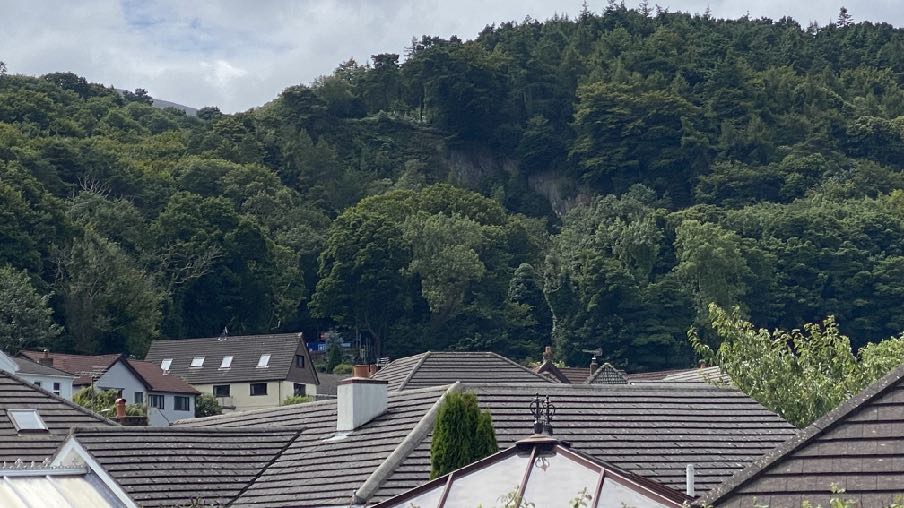
5.7 The overall impact of the development will be acceptable as the loss of trees as a proportion of the overall treed area here is very limited and the public view of this site incorporates the stone sides of the former quarry with trees surrounding it, sitting above the roofs of Barrule Park which will remain.
Sarah Corlett 31.08.2023
A photograph showing a view over the tiled roofs of residential houses towards a steep, densely wooded hillside under a cloudy sky.
Appendix One - policies
Strategic Plan
Strategic Policy 4: Proposals for development must:
(a) Protect or enhance the fabric and setting of Ancient Monuments, Registered Buildings(1), Conservation Areas(2) , buildings and structures within National Heritage Areas and sites of archaeological interest;
(b) protect or enhance the landscape quality and nature conservation value of urban as well as rural areas but especially in respect to development adjacent to Areas of Special Scientific Interest and other designations; and
(c) not cause or lead to unacceptable environmental pollution or disturbance.
General Policy 3: Development will not be permitted outside of those areas which are zoned for development on the appropriate Area Plan with the exception of:
(a) essential housing for agricultural workers who have to live close to their place of work; (Housing Policies 7, 8, 9 and 10);
(b) conversion of redundant rural buildings which are of architectural, historic, or social value and interest; (Housing Policy 11);
(c) previously developed land(1) which contains a significant amount of building; where the continued use is redundant; where redevelopment would reduce the impact of the current situation on the landscape or the wider environment; and where the development proposed would result in improvements to the landscape or wider environment;
(d) the replacement of existing rural dwellings; (Housing Policies 12, 13 and 14);
(e) location-dependent development in connection with the working of minerals or the provision of necessary services;
(f) building and engineering operations which are essential for the conduct of agriculture or forestry;
(g) development recognised to be of overriding national need in land use planning terms and for which there is no reasonable and acceptable alternative; and
(h) buildings or works required for interpretation of the countryside, its wildlife or heritage.
Environment Policy 1: The countryside and its ecology will be protected for its own sake. For the purposes of this policy, the countryside comprises all land which is outside the settlements defined in Appendix 3 at A.3.6 or which is not designated for future development on an Area Plan. Development which would adversely affect the countryside will not be permitted unless there is an over-riding national need in land use planning terms which outweighs the requirement to protect these areas and for which there is no reasonable and acceptable alternative.
Environment Policy 2: The present system of landscape classification of Areas of High Landscape or Coastal Value and Scenic Significance (AHLV’s) as shown on the 1982 Development Plan and subsequent Local and Area Plans will be used as a basis for development control until such time as it is superseded by a landscape classification which will introduce different categories of landscape and policies and guidance for control therein. Within these areas the protection of the character of the landscape will be the most important consideration unless it can be shown that:
(a) the development would not harm the character and quality of the landscape; or
(b) the location for the development is essential.
Environment Policy 3: Development will not be permitted where it would result in the unacceptable loss of or damage to woodland areas, especially ancient, natural and semi-natural woodlands, which have public amenity or conservation value.
Environment Policy 4: Development will not be permitted which would adversely affect:
(a) species and habitats of international importance:
(i) protected species of international importance or their habitats; or (ii) proposed or designated Ramsar and Emerald Sites or other internationally important sites.
(b) species and habitats of national importance:
(i) protected species of national importance or their habitats;
(ii) proposed or designated National Nature Reserves, or Areas of Special Scientific Interest; or
(iii) Marine Nature Reserves; or
(iv) National Trust Land.
(c) species and habitats of local importance such as Wildlife Sites, local nature reserves, priority habitats or species identified in any Manx Biodiversity Action Plan which do not already benefit from statutory protection, Areas of Special Protection and Bird Sanctuaries and landscape features of importance to wild flora and fauna by reason of their continuous nature or function as a corridor between habitats.
Some areas to which this policy applies are identified as Areas of Ecological Importance or Interest on extant Local or Area Plans, but others, whose importance was not evident at the time of the adoption of the relevant Local or Area Plan, are not, particularly where that plan has been in place for many years. In these circumstances, the Department will seek site specific advice from the Department of Agriculture, Fisheries and Forestry if development proposals are brought forward.
Environment Policy 22: Development will not be permitted where it would unacceptably harm the environment and/or the amenity of nearby properties in terms of:
i) pollution of sea, surface water or groundwater;
ii) emissions of airborne pollutants; and
iii) vibration, odour, noise or light pollution.
Environment Policy 23: When considering alterations and improvements to existing facilities the Department will require that consideration be given to the potential adverse impact of the proposed changes to existing neighbours.
Transport Policy 6: In the design of new development and transport facilities the needs of pedestrians will be given similar weight to the needs of other road users.
Appendix Two
Landscape Character Assessment
F5 SULBY RIVER
Key Characteristics
• Lower reaches of the Sulby River corridor (as it flows across the northern plain towards the sea at Ramsey).
• River corridor lined with mature deciduous vegetation, creating a sense of enclosure.
• Small and medium-scale irregular fields set along both sides of the river channels.
• Fields delineated by a combination of mature, low Manx hedgerows and traditional grey stone walls (which also line the main road corridors).
• Scattered settlement pattern, along the river course (relatively isolated farmsteads and houses).
• Sulby forms main settlement at western edge (marking point at which river emerged from Sulby Glen), and Ramsey to the east (where the river flows out into the sea).
• Dramatic views to the typically wooded slopes of the Northern Uplands to the south.
• Relatively strong sense of tranquillity throughout most of the character area.
Overall Character Description
This landscape character area contains the lower reaches of the Sulby River as it flows across the northern plain, eastwards towards the sea at Ramsey Bay. The course of the river begins within the Uplands, further to the south and flows rapidly, down Sulby Glen. At the foot of the Uplands, the course of the river becomes flatter and wider, with slower moving water. Within the character area, the river is lined along almost its entire length by mature deciduous vegetation, which often channels views along the river corridor and provides a strong sense of enclosure. Several small and medium scale irregular fields are set along both sides of the river channel (comprising a mixture of rough grassland, pasture and arable). These fields are delineated by a combination of mature, low Manx hedgerows and traditional grey stone walls. The main A3 (also forming part of the TT course) runs through the southern half of the area, hugging the base of the uplands to the south and a dismantled railway line also runs to the north of the river (now providing a mature landscape and recreation corridor). Several minor rural roads provide access to the area, and the river is crossed at fairly regular intervals along the west-east corridor. Sulby Bridge provides one of the main crossing points, and is a distinctive landmark feature within the surrounding landscape, alongside the colourful Ginger Hall hotel. Several farmsteads and relatively isolated houses also line the course of the river, set slightly back from the river channel. Traditional white walls and grey roofs dominate built character. The relatively intimate Sulby village nestles at the western end of the character area, marking the point at which the river corridor meets the low northern plain after its journey through Sulby Glen.
Settlement character within the village is dominated by traditional Manx architecture, with several rows of colourful terraced houses and cottages. At the eastern end, the river flows into Ramsey (a mediumsized seaside town), where the corridor becomes more open and is influenced by surrounding urban built development. As it meanders amongst the urban fabric, the river eventually forms the basis for Ramsey’s working harbour and then flows out to sea. Although views are generally channelled along the river corridor, a strong recognisable sense of place is apparent at Sulby, Sulby Bridge, Ramsey and set slightly back from the river corridor along its length (views to the dramatic southern upland backdrop). Overall, there is a relatively strong sense of tranquillity throughout the character area.
Key Views
• Views along the river corridor generally channelled by vegetation which lines the banks of the river.
• Dramatic views to the adjacent southern uplands, which provide a wooded backdrop within views southwards.
• At bridging points, open views from the river corridor may be obtained across adjacent fields which are set back from the line of the river.
• Views to and from the urban edges of Ramsey.
Historic Features
• Sulby Church (Registered Building)
• St. Stephen’s Church (Registered Building).
• Lezayre Road War Memorial and Cemetery.
Ecological Features
• Mature, diverse deciduous vegetation lining the river corridor.
• Mature hedgerows at field boundaries.
• Diverse habitats within the river corridor.
Evaluation of Inherent Landscape Sensitivities
• Strong sense of tranquillity away from main roads.
• Scattered settlement patterns of farmsteads along river’s course.
• Enclosed and wooded river corridor.
• Valuable aquatic riparian and wet meadow habitats alongside river.
• Minor rural roads enclosed by roadside vegetation.
• Vernacular character of buildings and churches.
• Presence of Manx Mile stones.
• Few vertical elements.
• Dramatic views south to Uplands.
• Field pattern delineated by a mixture of stone walls, relatively tall Manx hedge-banks and post and wire fences.
Landscape Strategy The overall strategy should be to conserve and enhance the character, quality and distinctiveness of this rural area with its scattered settlement pattern, relatively strong field pattern, a network of enclosed minor rural roads and its ecologically valuable aquatic and riparian habitats.
Copyright in submitted documents remains with their authors. Request removal
Source & Provenance
Official reference
23/01042/B
Source authority
Isle of Man Government Planning & Building Control