Loading document...
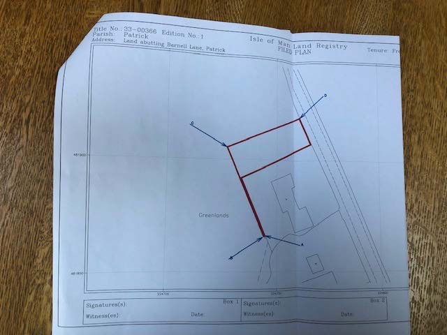
This is an amendment to application 23/00721/B, which in addition to the original full approval for operational development (involving building or engineering works) is to now include change of use from agricultural to residential in respect of the parcel of land as indicated on the attached site and location plans marked with green coloured hash lines, a proportion of which originally formed part of the curtilage of the property known as ‘Greenlands’.
The application as a whole is a scaled back scheme from previously approved applications; conversion of garage and roof space under approval, ref: 16/00298/B, full demolition and rebuild under approval ref: 18/01271/B, and conversion of garage and roof space under approval ref: 22/00903/B.
The following factually based timeline refers: 01/04/1969 – The original owner, Mr B senior purchased the ‘Greenlands’ plot from Mr & Mrs A senior and built the bungalow.
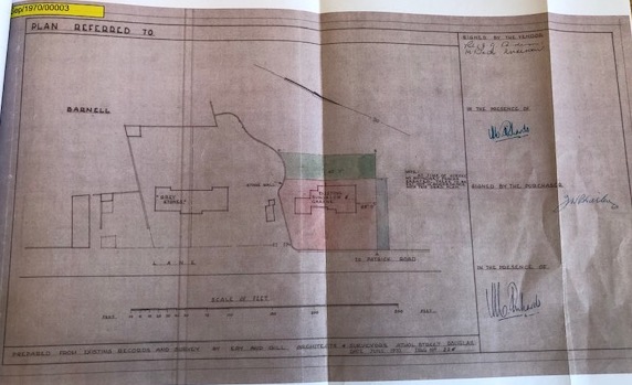
12/08/1970 - Mr & Mrs A senior ‘repurchased’ a section of the curtilage (now forming part of the subject ‘parcel of land’) surrounding the existing bungalow ‘Greenlands’ from Mr B senior (copy of the corresponding deed and map has already been provided to Miss Lucy Kinrade, planning officer but map image included below).
14/04/2016 - Mr B junior secures planning approval for extension to ‘Greenlands’ ref:
22/00903/B. 14/06/2023 – Mr & Mrs Caine apply for amendment to 22/00903/B and advised this effectively has to be a new application ref: 23/00721/B.
30/10/2023 - Mr & Mrs Caine notified by Miss Kinrade via email to their architect that the ‘parcel of land’ has been “unlawfully engulfed as part of the dwellings curtilage without approval”.
01/11/2023 – Mr & Mrs Caine make a telephone call to Miss Kinrade with arrangements then made to meet.
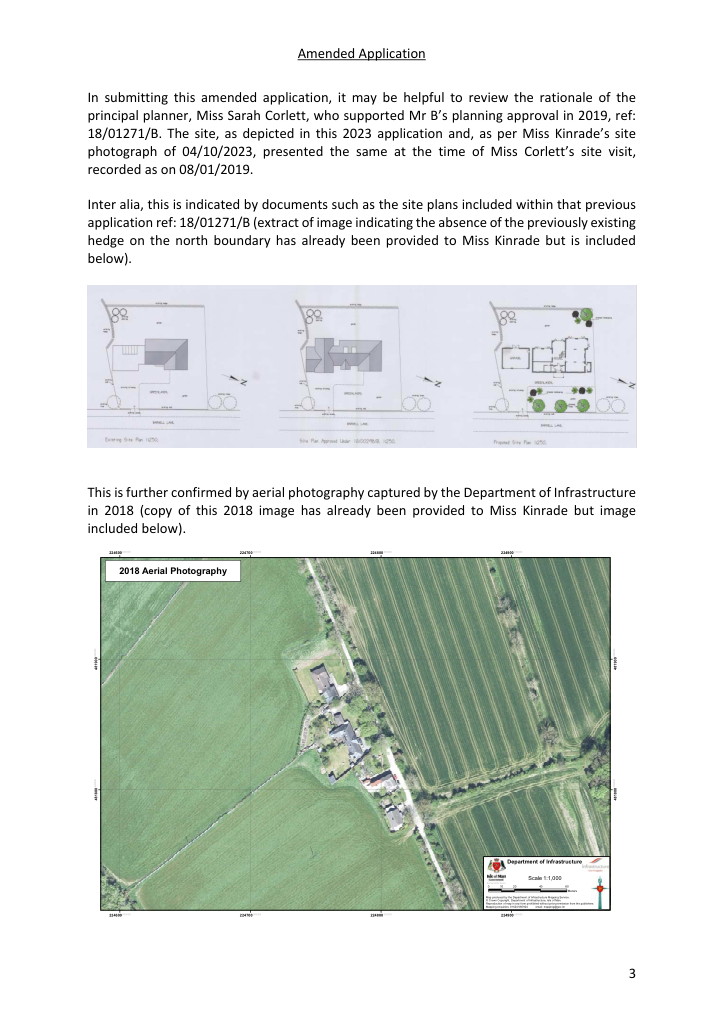
In submitting this amended application, it may be helpful to review the rationale of the principal planner, Miss Sarah Corlett, who supported Mr B’s planning approval in 2019, ref:
Inter alia, this is indicated by documents such as the site plans included within that previous application ref: 18/01271/B (extract of image indicating the absence of the previously existing hedge on the north boundary has already been provided to Miss Kinrade but is included below).
This is further confirmed by aerial photography captured by the Department of Infrastructure
481900000000
000000481900
481800000000
000000481800
Scale 1:1,000
0 10 20 40 60
Meters
Map produced by the Department of Infrastructure Mapping Service. © Crown Copyright. Department of Infrastructure, Isle of Man. Reproduction of map in any form prohibited without prior permission from the publishers. Mapping enquiries: 01624 685924 email: [email protected]
Consequently, an insight into how Miss Corlett addressed Mr B’s apparent oversight in regularising the ‘parcel of land’ at that juncture in 2019 and documented her assessment in that regard to be able to support the approval without any requirement being made of Mr B, to regularise the said land would undoubtedly be of assistance in the current context.
Noting that the application Miss Corlett supported had brought the focus of the north boundary to the fore as part of the consultation process due to the increased 2-storey height and footprint of the proposal and that it was subsequently placed before and approved by the prevailing planning committee, an insight into how Mr B’s apparent oversight in regularising the ‘parcel of land’ at that north boundary was presented to them at that juncture
This 2019 approval ref: 18/01271/B, is suggestive that both Miss Corlett and the prevailing planning committee can only have concluded that Mr B’s apparent oversight did not conflict with IOM Government Policy in respect of protecting the countryside and that it had neither harmed, nor would any continuance of the status quo cause any future harm to, the countryside. The applicant would concur with such a professional perspective, adding the following as laypersons.
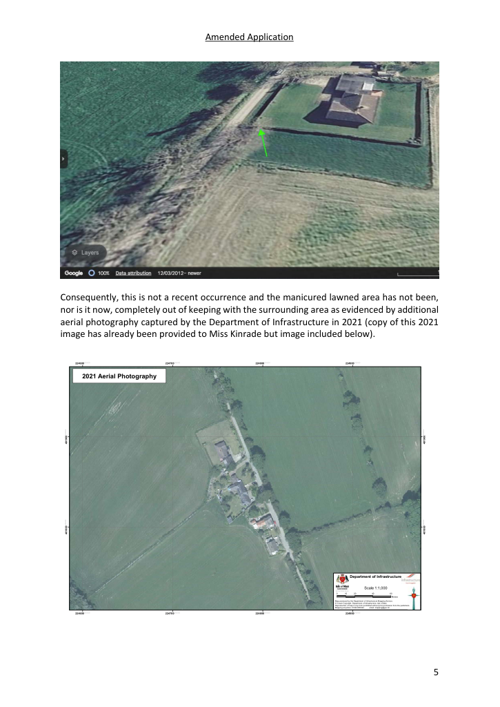
The parcel of land subject of this amended application is comparatively very small indeed and, as can been seen from the land registry document in respect of the 2007 transfer, new boundary fences physically ‘removing’ it as part of the field, were immediately required of Mr B. The Google Earth images already referenced within the original application depict these new boundaries as being in place on their available images dating back to circa 2012. Furthermore, when utilising the 3D view facility on the circa 2012 Google Earth images, it would appear that a section of the pre-2007 north boundary where it joined the east boundary had already been removed (copy of the corresponding 3D image has already been provided to Miss Kinrade but image included below with an arrow for ease of reference).
Consequently, this is not a recent occurrence and the manicured lawned area has not been, nor is it now, completely out of keeping with the surrounding area as evidenced by additional aerial photography captured by the Department of Infrastructure in 2021 (copy of this 2021 image has already been provided to Miss Kinrade but image included below).
481900000000
000000481900
481800000000
000000481800
Scale 1:1,000
0 10 20 40 60
Meters
Map produced by the Department of Infrastructure Mapping Service. © Crown Copyright. Department of Infrastructure, Isle of Man. Reproduction of map in any form prohibited without prior permission from the publishers. Mapping enquiries: 01624 685924 email: [email protected]
When considered in comparison with the previous planning approvals and their increased 2storey height and footprint, the proposed amendment in relation to change of use in conjunction with the original application wouldn’t have any negative impact upon the character and quality of the landscape.
The application as a whole, would see the complete renovation of an existing rural property currently requiring some much-needed TLC with a retrofit very clearly focused on the future in terms of the IOM Government’s environmental targets. This coupled with the cultivation of the garden, for example with the introduction of new fruit trees, can only have a beneficial result on both the landscape and the wider environment.
Copyright in submitted documents remains with their authors. Request removal