TOWN AND COUNTRY PLANNING ACT 1999 TOWN AND COUNTRY PLANNING (DEVELOPMENT PROCEDURE) ORDER 2019 1512-4.2.1 V1.0 MAY 2021
Planning Statement
APPLICATION REFERENCE: TBC PROPOSAL: ERECTION OF SINGLE DETACHED DWELLING WITH INTEGRAL GARAGE ADDRESS: LAND EAST OF BAY VIEW HOTEL, BETWEEN SHORE ROAD (UNDERWAY) AND BAY VIEW ROAD, PORT ST MARY, ISLE OF MAN AUTHOR: EUAN P. H. CRAINE, B.Arch, M.Arch, ADPPA, ARB, RIBA
HAVEN HOMES LIMITED THE OLD CHAPEL 32-34 MALEW STREET CASTLETOWN ISLE OF MAN IM9 1AF PHONE 01624 835222 EMAIL [email protected] WEB WWW.HAVEN.IM
0.1 Contents
1.0 Introduction 3
2.0 The Site and its Surroundings 3
3.0 Planning History 4
4.0 Land-Use Zoning 5
5.0 The Proposal 6
6.0 Structural Strategy 7
7.0 Elevational Treatment and Roof-Line 8
8.0 Drainage and Flood Risk 11
9.0 Parking 13
10.0 Summary 14
0.2 Appendices
A Schedule of drawings in support of the Application
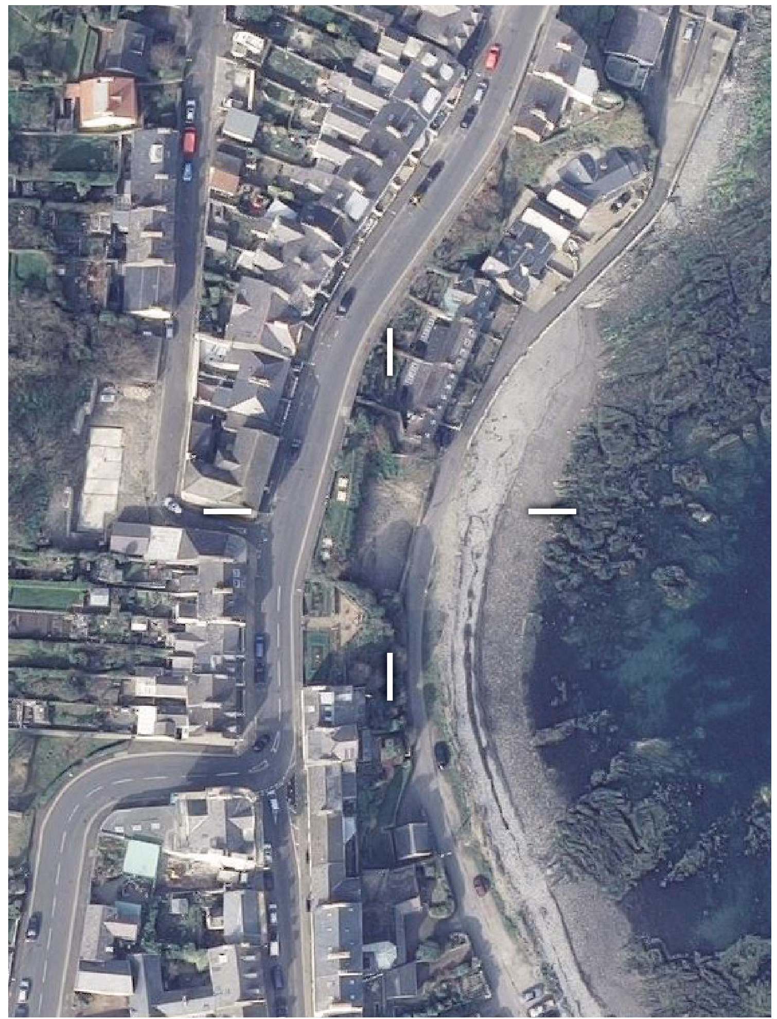
B Aerial Photography Extract c.2013
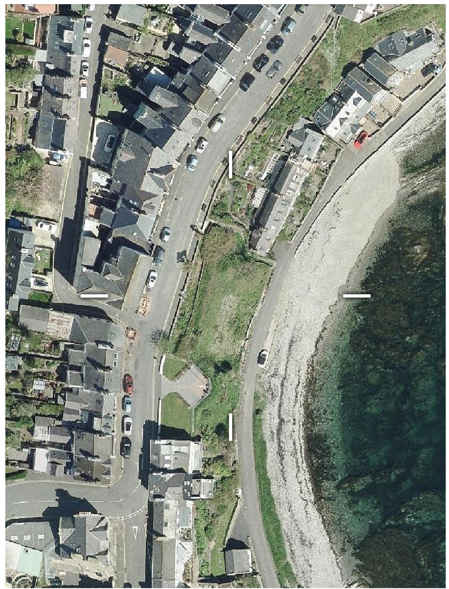
C Aerial Photography Extract c.2019
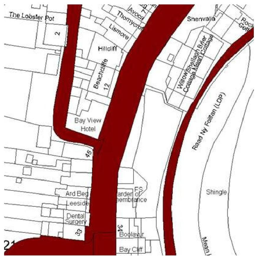
D Highway Record Map Extract 2021
E P.A. 09/01295/B Initial Decision Notice 27/05/10
F P.A. 09/01295/B Inspector’s Report 9/11/10
G P.A. 09/01295/B Appeal Decision Notice 8/12/10
H P.A. 10/01892/B Initial Decision Notice 26/04/11
I P.A. 10/01892/B Inspector’s Report 26/04/11
J P.A. 10/01892/B Appeal Decision Notice 08/08/11
K P.A. 10/01892/B Minister Re Commencement 18/01/16
1.0 INTRODUCTION
1.1 This Statement has been prepared by Haven Homes Limited (the Applicant) and is intended to be read and considered together with all associated submissions in the application bundle.
1.2 The Application is made for full consent for the Proposal (pursuant to the Act1 , DPO2, IMSP3 and APS4) without prejudice to any existing statutory consents, licences or other provisions in respect of the land of the Site (whether contained wholly or partly within the Site) or any concurrent applications for statutory consent in relation to either the land or the Proposal.
1.3 The Proposal is as described in this Statement and as represented in the drawings scheduled at Appendix A. It may be summarised as the construction of a single dwellinghouse
— as defined at UCO5 §3 (Class 3.3) — with an integral garage.
1.4 The Site is as delineated, edged red, on the Location Plan and Site Plan. The Applicant is the registered freehold owner of the Site. The Applicant’s additional land ownership is as delineated, edged blue, on the Location Plan and Site Plan.
2.0 THE SITE AND ITS SURROUNDINGS
2.1 The Site is a plot adjacent to Shore Road (the Underway), east of the Bay View Hotel on Bay View Road.
2.2 The Site is bound:—
n) on the north by a public footpath approximately 1m wide, connecting Bay View Road and Shore Road via a meandering set of concrete steps between the respective road levels, with Willow Cottage beyond (the first of three terraced properties at Willow Terrace);
e) on the east by Shore Road (shown as maintainable at public expense on the Highway Record Map, see appx. D), with car parking spaces in the Applicant’s ownership on the far side of Shore Road and the shingle foreshore of the bay beyond;
s) on the south by a rock outcrop under a remembrance garden of the Royal British Legion, with Boolavur beyond (a private property at a distance of some 22m from the Site);
w) on the west by land associated with the Bay View Hotel, formerly used as a beer garden, with Bay View Road and the Bay View Hotel beyond.
2.3 It is understood that, after having obtained planning consent to erect a pair of dwellings, the Applicant’s predecessor in title scraped the ground of the Site. Vegetation (including nonnative species) has subsequently grown over and across the bare soil, as is shown in Aerial photography (cf. appx. B, C).
1 Town and Country Planning Act 1999
2 Town and Country Planning (Development Procedure) Order 2019
3 Town and Country Planning (Isle of Man Strategic Plan) Order 2016 and its Written Statement
4 Town and Country Planning (Area Plan for the South) Order 2012, its Written Statement (as amended 2014) and Maps referred to therein
5 The Town and Country (Use Classes) Order 2019
3.0 PLANNING HISTORY
3.1 The Site’s planning history should be a material consideration6 in assessing the Application, not least because such is standard practice (as is seen in the relevant cases noted below), but especially given the exhaustive exploration and consideration of issues concerning the Site, its proposed use, and the conclusions already drawn. The IMSP has since been updated, however most policies remain identical. Although the Planning Authority now has the benefit of an updated Area Plan, the IMSP still prevails in the event of any inconsistency pursuant to IMSP §1.4.4 (the IMSP being more recent than the APS).
3.2 PA 08/02321/B sought consent for:“Construction of three dwellings with associated parking”
The 2008 PA was not granted approval by the Planning Committee, principally due to the combined massing (scale) of the three terraced dwellings of four storeys, and also an apparently unviable vehicular access onto Bay View Road.
3.3 PA 09/01295/B sought consent for:“Erection of two dwellings with integral garages and associated visitor parking”
The 2009 PA sought two semi-detached dwellings of three storeys and was initially granted approval by the Planning Committee. At appeal, the independent inspector had recommended that the application be approved. The Deputy Minister did not consent, however, considering there to be insufficient detail provided with regards to a proposed car parking lay-by — this decision notwithstanding the inspector’s view that such detail could have been dealt with by a condition precedent and would not have merited an entirely new application.
3.4 P.A. 10/01892/B (the Extant Approval) sought consent for:“Erection of two dwellings with integral garages and associated visitor parking”
The 2010 PA was essentially the 2009 PA resubmitted, but with additional information concerning the lay-by. This was approved and an appeal against the decision was dismissed.
a) This Extant Approval had been subject to time limitation regarding commencement. This condition was discharged in exercising the approval to construct the lay-by, as the works would not otherwise have been permissible under PDO7 provisions and (as a consequence of the appeal brought against the 2009 PA which led to Condition 3 being imposed) the works are correctly classed as “development” within the meaning of §6(2)(d)(iii) of the Act, which states:—
“the following are engineering operations constituting development […] the execution of any road works preliminary or incidental to the erection of a building”
b) Furthermore, DEFA have previously confirmed (and reconfirmed) that the Extant Approval has commenced (see appx. K) and it is therefore clear that the Extant Approval remains a fully and indefinitely exercisable statutory consent.
6 within the meaning of §10(4)(d) of the Act
7 Town and Country (Permitted Development Order) 2012, both prior to and after its amendment in 2019)
4.0 LAND-USE ZONING
4.1 Subject to a number of criteria (discussed in the following parts of this Statement), General Policy 2 (IMSP §6.2) provides that proposals that are in accordance with the land-use zoning shown in the relevant Area Plan will normally be permitted.
4.2 Environment Policy 1 (IMSP §7.5.1) provides that the countryside consists of all land outside of those settlements scheduled at IMSP Appendix 3 (which includes Port St Mary) or land not otherwise zoned for development on the relevant Area Plan. Interacting policies concerning the countryside require additional standards than are normally applied inside villages.
4.3 The settlement boundaries of Port St Mary are delineated on APS Map 7. The Site is contained within these boundaries.
4.4 The Area Plan in effect at the time of the Extant Approval was the 1982 Plan8, in which the Site is zoned Predominantly Residential Use. In Port St Mary the 1982 Plan is replaced by the APS, in which the Site remains zoned Predominantly Residential on Map 7.
4.5 Environment Policy 42 (IMSP §7.34.1) provides that open or green spaces contributing to the amenity of a particular area will be identified for preservation on the relevant Area Plan.
4.6 A number of parties, in their various representations concerning the applications discussed at §3 of this Statement, adduced from the draft Port St Mary Village Plan 2000 and the draft Area Plan for the South 2009 that the Site was once intended to be zoned as Public Open Space. The Planning Authority has, on several occasions, clarified that the Public Open Space zoning indicated on those draft plans was only ever intended to apply to the remembrance garden. Indeed, no reference to the Site is found in the respective written statements to those draft plans, which were not adopted in any event. On APS Map 7, the Site is unequivocally zoned as Predominantly Residential and the remembrance garden is zoned as Public Open Space. The Site is not identified on the adopted Area Plan. As such, Environment Policy 42 is inapplicable to the Site or the Proposal.
4.7 in short, the land of the Site:—
a) is within the settlement boundaries of Port St Mary and so cannot be said to be within the countryside;
b) is in the registered freehold ownership of the Applicant, is not publicly accessible and cannot be said to be public open space;
c) is clearly zoned as Predominantly Residential and therefore cannot be said to be ‘white land’; and
d) is, in any event, the subject of an exercisable statutory consent which itself establishes the accepted principle of residential use on (and development of) the Site.
8 loM Planning Scheme (Development Plan) Order 1982, its Written Statement and Map referred to therein
5.0 THE PROPOSAL
5.1 The Proposal is for the construction of a single, detached, three-bedroom residential dwelling of three storeys. The general arrangement may be characterised as an “inverted living” or “upside-down” house, with principal accommodation at the top floor in order to enjoy panoramic views to the east.
5.2 The principal elevation faces to the east, as is the case of all of the buildings on Shore Road. Views out across the harbour, breakwater and wider bay are the main attraction of the Site, which is constrained on all other sides by surrounding development and natural topography. The Proposal therefore seeks the maximum possible enjoyment of the eastern views.
5.3 The following subsections describe the arrangement of the accommodation within the Proposal. Each floor is divided into three main parts, as a consequence of the structural strategy discussed in §6 this Statement. The three divided parts of each floor are referred to as ‘left’ ‘centre’ and ‘right’ when facing the front (east) elevation:—
0) There is no habitable accommodation proposed at ground floor level (as is the case in the Extant Approval), with the left part containing a garage and the right part a gymnasium, including shower and sauna. The principal access into the dwelling is via a central, covered entrance that is recessed into the front elevation. The central part of the ground floor consists of an entrance hall leading upstairs to the main accommodation.
1) The centre of the first floor consists of a partial atrium over the entrance hall and a landing between a bedroom suite to the left and another bedroom suite and storage space to the right. A further flight of stairs leads up to the second floor.
2) The centre of the second floor consists of a dining space connected with a kitchen to the rear of the right part. The rear of the central part contains a utility room and WC. The front of the right part contains a lounge, also connected with the kitchen. The left part of the floor contains the master bedroom suite. The front elevation is recessed at the centre part of the second floor, providing external private amenity space to the occupier, framing the view to the east and serving each part of the second floor. The kitchen has external access onto a path that leads to the public footpath between the respective road levels.
5.4 The extent to which the rear of the dwelling steps backwards is seen on the section drawing provided and also when comparing the position of the lift core on the respective floor level plans. This is a response to the structural strategy of the proposal, which in turn takes cognisance of the natural topography of the Site.
6.0 STRUCTURAL STRATEGY
6.1 Having reviewed the Extant Approval, in which retaining structure behind the dwelling would be independent from the dwelling itself, the Applicant’s Engineers (BB Consulting Engineers Ltd.) have instead developed a strategy that integrates with the dwelling’s walls. Two internal walls and two side elevations (north and south) would be constructed in reinforced concrete, effectively dividing each floor into the three parts described in §5 of this Statement. These four walls would act as buttresses, standing perpendicular to a groundretaining structure at the rear of the dwelling. The retaining structure itself would step further backwards from Shore Road at each storey, reflecting the natural topography of the Site.
6.2 It is considered that this will allow for more spatially efficient development, will eliminate the redundant void that would otherwise be present if exercising the Extant Approval and would minimise both excavation towards Bay View Road and projection of the dwelling towards Shore Road. The Applicant hastens to add that the Proposal should in no way be construed as a criticism of the design of the Extant Approval and the Applicant is entirely confident in the feasibility of the Extant Approval. The Proposal merely reflects an alternative design approach that the Applicant instead wishes to adopt.
6.3 Environment Policy 28 (IMSP §7.22.2) states:“Development which would be at risk from ground instability or which would increase the risk from ground instability elsewhere will not be permitted unless appropriate precautions have been taken.”
6.4 As the Applicant has already appointed Engineers to the project, and as the Proposal will subsequently be subject to controls under both Building Control and Health and Safety legislation, it is considered that the Proposal — like the Extant Approval complies with Environment Policy 28. Regarding this point, the Planning Authority’s opinion concerning the Extant Approval was noted by the independent inspector to the 2010 PA appeal (at ¶51 of their report, see appx. I):—
“The proposal complies with Environment Policy 28 of the Strategic Plan relating to ground stability. The stability of the slope is a material consideration, and there have been incidences of ground slippage nearby. However, the plans were drawn in consultation with a Structural Engineer, whose advice was taken, and structural stability would be dealt with at the building regulations stage. The Planning Authority does not need exact details of the scheme at this planning stage, but only needs to know that it is feasible for a scheme to be implemented. The previous Inspector concluded that an engineering solution was possible, and that the need to comply with building regulations would provide the ‘appropriate precautions’ which Environment Policy 28 required.[…]”
6.5 The inspectors to the 2009 PA (at ¶33 - ¶34 of their report) and 2010 PA (at ¶82 - ¶83 of their report) both concur with the Planning Authority’s opinion. The appointment of an Engineer to determine the structural feasibility of the Proposal and to assist in the preparation of a Building Regulations application is itself the appropriate precaution in mitigation of the risks described in Environment Policy 28, which are correctly controlled by the relevant authorities under separate legislation.
7.0 ELEVATIONAL TREATMENT AND ROOF-LINE
7.1 General Policy 2 (IMSP §6.2) states (in part):“Development which is in accordance with the land-use zoning […] in the appropriate Area Plan […] will normally be permitted, provided that the development:[…]
(b) respects the site and surroundings in terms of the siting, layout, scale, form, design and landscaping of buildings and the spaces around them;
(c) does not affect adversely the character of the surrounding landscape or townscape;[…]
(e) does not affect adversely public views of the sea;[…]”
7.2 Environment Policy 35 (IMSP §7.29.2) states:“Within Conservation Areas, the Department will permit only development which would preserve or enhance the character or appearance of the Area, and will ensure that the special features contributing to the character and quality are protected against inappropriate development.”
7.3 The Site is not within, in the vicinity of nor in a sight-line from any CA9. If Environment Policy 35 were applicable to the Site (which it is not) it is considered that the Proposal would in any event be in accordance. Moreover, the Site contains no RB10 and is not in the contextual vicinity of, nor in a sight-line from, any RB. MNH have previously confirmed that the Site contains no archaeological interest, therefore PPS 1/0111 has no effect. The Proposal is not subject to standards any greater than those applicable to any other Predominantly Residential sites.
7.4 It is noted that a draft Character Appraisal12 was published concerning Port St Mary, describing a proposed CA. The independent inspector to the 2019 PA appeal correctly stated (at ¶25 of their report, see appx. F):—
“The site is not in a conservation area: whilst noting the suggestion […] that it might be within such an area in the future, this cannot be assumed and does not apply at present.”
7.5 The independent inspector appointed to the 2010 PA appeal reiterated (at ¶74 of their report, see appx. I):—
“I also note that, while the site would be part of a Conservation Area proposed in the [draft] Southern Area Plan, it is still the case that this designation has yet to be confirmed. Consequently, little weight can be attached to that matter.”
7.6 APS §5.17.2 notes that CAs are not approved as part of the Area Plan process (being distinct provisions at §18 and §2(2)(b) of the Act respectively). As the CA proposed in the draft Character Appraisal was not subsequently designated, its standing as a material planning consideration remains minimal.
7.7 No advance towards the implementation of the proposed CA is apparent and, given that considerable time has passed, it seems unlikely that the proposed CA will be further progressed. Regardless, it is considered that the Proposal would not in any way prejudice the future designation of a CA and the Applicant takes note of the contents of the draft Character Appraisal.
9 §18 of the Act - “Conservation Area”
10 §14 of the Act - “Registered Building”
11 Policy and Guidance Notes for the Conservation of the Historic Environment of the Isle of Man 2001
12 Port St Mary Draft Conservation Area Character Appraisal February 2009
7.8 IMSP §4.3.8 states:—
“The design of new development can make a positive contribution to the character and appearance of the Island. Recent development has often been criticised for its similarity to developments across the Island and elsewhere – “anywhere” architecture. At the same time some criticise current practice to retain traditional or vernacular designs. As is often the case the truth lies somewhere between the two extremes. All too often proposals for new developments have not taken into account a proper analysis of their context in terms of siting, layout, scale, materials and other factors. At the same time a slavish following of past design idioms, evolved for earlier lifestyles can produce buildings which do not ref lect twenty first century lifestyles including accessibility and energy conservation. While there is often a consensus about what constitutes good and poor design, it is notoriously difficult to define or prescribe.”
7.9 Housing Policy 6 (IMSP §8.7.1) states:—
“Development of land which is zoned for residential development must be undertaken in accordance with the brief in the relevant area plan, or, in the absence of a brief, in accordance with the criteria in paragraph 6.2 of this Plan. Briefs will encourage good and innovative design, and will not be needlessly prescriptive.”
7.10 APS §1.13.1 defines the term Development Brief. The APS identifies 27 № sites that are the subject of a respective brief. §4.6 of this Statement establishes the zoning of the Site and that the Site is not referred to in the APS. The Site is not the subject of a sitespecific brief as referred to in Housing Policy 6. It is therefore the general principles provided at General Policy 2 that are applicable to the Proposal — like the Extant Approval.
7.11 Landscape Proposal 7 (APS §3.13) states:“The site in front of the Bay View Hotel on Bay View Road creates an important space between the buildings allowing for views across the bay and beyond. To ensure the continuation of this view no building on the Shore Road will be permitted to exceed the existing road level.”
7.12 The ridge level of the Extant Approval (which is lower than the road level) has been treated as a vertical constraint in the design of the Proposal, notwithstanding the provision of Landscape Proposal 7 that a development as tall as the level of Bay View Road could be acceptable. As the height of the Extant Approval is already deemed acceptable under IMSP, and as the Proposal would in any event be lower in height than the Extant Approval, it is considered the Proposal accords with both General Policy 2(e) and Landscape Proposal 7.
7.13 The draft Character Appraisal describes the built environment of the area and the diverse range of buildings types as being representative of the particular eras in which they were built. Put succinctly, the draft Character Appraisal states (at p.15):—
“Due to the phased development of the area proposed to be included within the conservation area, there is no prevalent style of construction. However, the vast majority of properties are built in stone, many having a render coat.”
7.14 Were their construction attempted today, Port St Mary’s older, stone-built houses would be prohibited by modern statutory requirements, especially with regards to ever-increasing standards towards built fabric and energy efficiency. The form, material, aesthetic and haptic qualities of these older buildings
— which have come to help define a character over time are a product of the construction techniques and specialist skills that were contemporarily available and employed, and the requirements of the occupants for whom they were built. Likewise, the Proposal responds to the particular nature of the Site with contemporary techniques and specialist skills, in a response to current requirements.
7.15 The independent inspector appointed in the appeal to the 2009 PA stated (at ¶25 of their report):—
“[…] the buildings along Shore Road are a mixture of ages, styles and heights,including traditional cottages, conversions of old building such as the Old Sail Loft, and modem dwellings with integral garages. […]”
7.16 The independent inspector appointed in the appeal to the 2010 PA noted the case for the Planning Authority (at ¶46 of their report) that:—
“[…] The dwellings take their design lead from new properties further north, and would not be out of keeping with the surroundings given the variety of dwellings nearby. […]”
7.17 As the apparent consensus between both inspectors and the Character Appraisal is that there is no single, prevalent style in Port St Mary, it is considered inappropriate to disguise the Proposal’s structure to emulate any single period of the village’s past development. Rather, the more appropriate architectural treatment of the Proposal’s structure is for the three divided parts to be expressed externally, legitimately representing how the building is constructed and adding to the variety already found in the surrounding built environment.
7.18 Some modern attempts to reproduce traditional built forms have, regrettably, resulted in relatively flat and uninteresting façades that lack the subtle qualities of the buildings that they were supposed to reference — the Applicant does not wish to perpetuate this practice. Moreover, efforts to reproduce qualities found in historical buildings can often detract from the original. The Applicant has concluded that treating the Proposal with an approximation of a historical style or construction technique would be disingenuous with regards to the Proposal’s structure, but would also potentially detract from the authentic character found in Port St Mary that has been acquired with the passage of time.
7.19 In short, there has been careful consideration regarding the constraints of the Site and also the form and materials of the Proposal. The façade is deliberately intended to express the underlying structural solution and, as has been the case during the development of the village, employs contemporary construction techniques. In this way, the Proposal is conceived of as a continuation of Port St Mary’s development and not an attempt to re-write its past with a spurious narrative.
8.0 FLOOD RISK AND DRAINAGE
8.1 IMSP §7.12.5 contains policies concerned with local areas subject to flooding. Environment Policy 10 states (in part):—
“Where development is proposed on any site where in the opinion of the [Department] there is a potential risk of f looding, a f lood risk assessment and details of proposed mitigation measures must accompany any application for planning permission. […]”
8.2 Environment Policy 13 (IMSP §7.12.5) states:“Development which would result in an unacceptable risk from f looding, either on or off-site, will not be permitted.”
8.3 The independent inspector appointed in the appeal to the 2009 PA found (at ¶37 of their report) that:—
“[…] The planning authority did not require a detailed f lood risk assessment to be made as part of the application. Objectors say that such an assessment should have been required, but that was a matter for the authority to decide at the time, on the advice of the then Department of Transport Drainage Division, who did not advise that a f lood risk assessment was necessary. On balance, bearing in mind that other new dwellings have been approved along Shore Road and that the proposal would not cause any additional f lood risk to other properties, I find that the possible risk of f looding would fall within an acceptable limit. On that basis the proposal would comply with Environment Policies 10-13 of the Strategic Plan.”
8.4 The independent inspector appointed in the appeal to the 2010 PA found (at ¶87 of their report) that:—
“[…] it is clear that the last Inspector took into account that there was a distinct possibility of the appeal site being liable to marine f looding. He acknowledged that there was evidence which showed that storm damage had occurred in the past to parts of the shore in this vicinity. Consequently, it seems to me that the risk that was taken into account in the last appeal was not significantly less than the risk that is indicated by the new evidence from the Indicative Flood Map. That Map is not suggesting a particularly high frequency of tidal f looding of the part of the appeal site to the east of Shore Road”
8.5 Since the Extant Approval, authority13 in relation to flooding and drainage was transferred14. It is the Planning Authority’s duty to notify the Applicant and request any further particulars15 if such are required by the relevant authority to be provided. The Applicant is unaware of any new requirement that a FRA be provided in relation the Site and considers that the Proposal in any event complies with Environment Policies 10-13 — like the Extant Approval.
13 §3 of the Flood Risk Management Act 2013 (as amended) - “Authority”
14 §4 of the Transfer of Functions (Manx Utilities Authority) Order 2014
15 §5(6) of the DPO
8.6 General Policy 2 (IMSP §6.2) states (in part):“Development which is in accordance with the land-use zoning […] in the appropriate Area Plan […] will normally be permitted, provided that the development:[…]
(j) can be provided with all necessary services;[…] (l) is not on contaminated land or subject to unreasonable risk of erosion
or f looding […]”
8.7 The independent inspector appointed in the appeal to the 2009 PA found (at ¶35 of their report) that:—
“[…] This is a matter which could suitably be left to the control of building regulations. If no satisfactory arrangements can be devised, any planning approval could not be implemented.”
8.8 The independent inspector appointed in the appeal to the 2010 PA found (at ¶84 of their report) that:—
“On […] drainage and f looding, there is some new information since the previous appeal. Although the application proposed the use of soakaway drainage, it has been clarified that an alternative exists for dealing with surface water by draining this into the sea. This has apparently been informally agreed by the Harbour Division, and it ref lects the means of drainage employed on another site nearby at Rock Cottage. Consequently, there is less reason to regard surface water drainage as a matter which might prevent implementation of the proposed development than there was at the time of the previous appeal. In any event, it remains the case that this is a matter which could suitably be left to the control of the building regulations, as the previous Inspector stated.”
8.9 The Proposal would make identical arrangements for drainage as the Extant Approval would, hence the Applicant considers that the drainage element of the proposal is already approved and fully exercisable insofar as the Act is concerned. In any event, and as was previously determined, the feasibility of the drainage of the Site has been established and its implementation is correctly controlled by the relevant authority under Building Control legislation.
9.0 PARKING
9.1 General Policy 2 (IMSP §6.2) states (in part):“Development which is in accordance with the land-use zoning […] in the appropriate Area Plan […] will normally be permitted, provided that the development:[…]
(h) provides satisfactory amenity standards in itself, including where appropriate safe and convenient access for all highway users, together with adequate parking, servicing and manoeuvring space;
(i) does not have an unacceptable effect on road safety or traffic f lows
on the local highways[…]”
9.2 Transport Policy 7 (IMSP §11.5.3) states:“The Department will require that in all new development, parking provision must be in accordance with the Department’s current standards. The current standards are set out in Appendix 7.”
9.3 IMSP §A.7.1 states (in part):“High levels of car ownership have led to an increase in the level of parking expected for new residential development, and outside of town centre locations these standards should not be relaxed. Newbuilt residential development should be provided with two parking spaces per dwelling, at least one of which should be within the curtilage of the dwelling and behind the front of the dwelling […]”
9.4 IMSP §A.7.6 states (in part):“Parking Standards […] Typical Residential: 2 spaces per unit, at least one of which is retained within the curtilage and behind the front of the dwelling.”
9.5 Condition 3 to the Extant Approval states:“Prior to the commencement of any works on the construction of the dwellings, including excavation of the site, the parking area shown on the approved plans must be constructed to at least base course level and the beach-side slab finished in stone as shown. The dwellings may not be occupied until such time as the parking area has been completed and once completed, the space must be retained for use in association with the approved dwellings.”
9.6 As previously discussed, the approved lay-by has already been constructed. These spaces will be available to the occupants of the dwellinghouse as was their intended use under Condition 3 to the Extant Approval.
9.7 Notwithstanding that relaxations are available to the Applicant (given the Site’s location) the Proposal contains an integral garage. As parking provision behind the front of the dwelling will be provided, no relaxation is sought in this respect. The garage will also provide space to securely store bicycles, in cognisance of the Government’s active travel scheme.
9.8 Whereas the Extant Approval includes two separate garages, each with a door some 2.4m wide, the Proposal has one garage with a 4.5m wide door. This represents a considerable improvement over the Extant Approval, both in terms of visibility and manoeuvrability (within the same Site constraints). Highway Services16 had required that the garage doors of the Extant Approval not open out over the highway, and so the garage door of the Proposal is to comply with this requirement.
16 A division of the Isle of Man Government Department of Infrastructure
10.0 SUMMARY
10.1 The Application is for full planning consent for the Proposal.
10.2 The Site is not subject to standards any greater than are normally applied within similarly zoned sites.
10.3 The zoning of the Site is Predominantly Residential. Both the Extant Approval and the Proposal are for residential use. The principle of development on the Site is already established.
10.4 The Extant Approval concerns the Site and is a material consideration.
10.5 The Extant Approval remains exercisable and the Application is without prejudice to this statutory consent.
10.6 Detailed structural and drainage designs are for determination by the relevant authorities. Compliance with planning policy need only be demonstrated by establishing feasibility. Experts have been appointed in order to obtain necessary consents under separate legislation.
10.7 It is for the Planning Authority to notify the Applicant should any further particulars be required.
10.8 It is considered that the single dwelling proposed would be less intrusive on the Site and its neighbouring amenity than is already approved. The Proposal should therefore be more acceptible in planning terms that the Extant Approval.
10.9 Notwithstanding that CA policy does not apply to the Site, the Applicant has given greater regard than would normally be required and careful consideration has been made of the Site’s context. An expert opinion and reasoned explanation behind the design approach of the Proposal has been provided.
10.10 Subject to obtaining the consent sought by the Applicant, it is hoped that apparent misgivings surrounding the Extant Approval will soon be brought to an end by the implementation of the Proposal.
Appendix — A
SCHEDULE OF DRAWINGS SUBMITTED IN SUPPORT OF THE APPLICATION
Appendix A
Schedule of drawings submitted in support of the Application
Author Reference Drawing Title Haven Homes 1512-001.00 Location Plan Haven Homes 1288-001.01 Site Plan Haven Homes 1288-101.02 Proposed Plans, front Elevation
Views A, B & C and Section A-A
Haven Homes 1512-001.03 Comparative Photomontage A
Haven Homes 1512-001.04 Comparative Photomontage B IoM Groundmodels 1912J-01 Topographical Survey
Appendix — B
EXTRACT OF AERIAL PHOTOGRAPHY C. 2013
$\square$
Appendix — D
EXTRACT OF THE HIGHWAY RECORD MAP
$\qquad$
Aerial site location map showing a coastal road, residential properties, and a beach with white boundary markers indicating the plot.
Application Ref. No:09/01295/B Ref: PF/PC/AA
Isle of Man Town and Country Planning Act 1999
The Town and Country Planning (Development Procedure) Order 2005
Mr Ashley Pettit Ashley Pettit Architects James Place Victoria Road Douglas IM2 4HD
In pursuance of powers granted under the above Act and Order the PLANNING COMMITTEE of the Department of Infrastructure does hereby APPROVE the following application made on behalf of:
Name: Mr Len Chatel Proposal: Erection of two dwellings with integral garages and associated visitor parking (Re advertised due to amended plans received) at: Land in front of Bay View Hotel between Shore Road Underway and High Street Port St. Mary Isle of Man which was considered on 21st May 2010, subject to compliance with the conditions specified below.
Date of Issue: 27th May 2010
Murray House Mount Havelock Douglas Mrs P Faragher
Deputy Secretary to the Planning Committee
SCHEDULE OF CONDITIONS:
1. The development hereby permitted shall commence before the expiration of four years from the date of this notice
2. This permission relates to the erection of two dwellings as shown and described in drawings P01, P06, P09 and the Structural Engineer’s report all received on 4th August, 2009 and P02A, P03A, P07A, P05A and P10 received on 2nd December, 2009 and 058 received on 14th May, 2010.
A site location map showing the proposed development site highlighted in red, surrounded by properties like the Bay View Hotel and the Raad Ny Foillan path.
Appendix — F
INSPECTOR’S REPORT REGARDING P.A. 09/01295/B
Application Reference: Tbc
PROPOSAL: ERECTION OF SINGLE DETACHED DWELLING WITH INTEGRAL GARAGE
ADDRESS: LAND EAST OF BAY VIEW HOTEL, BETWEEN SHORE ROAD (UNDERWAY) AND BAY VIEW ROAD, PORT ST MARY, ISLE OF MAN
Appeal No: AP10/0072 Application No: 09/01295/B
Report on Inquiry into Planning Appeals
Inquiry held on: 26 October 2010 Site inspection on: 25 October 2010
Appeals against approval for the construction of two new three-storey houses with integral garages and associated visitor parking, land at Shore Road Underway in front of Bay View Hotel, Port St Mary. The appeals are by:
Mr D Maddrell Mr Kenneth Leigh Port St Mary Commissioners MsG Wheeler Mr and Mrs Hulton. Present: For Appellants Mr P Collett of MacOwan Collett, Consulting Engineers, for Port St Mary Commissioners Mr N Hourican for Port St Mary Commissioners Mr B Boyle Ditto
Mr J Roberts Ditto
Mr K Ryzner for Mr Leigh and Ms Wheeler.
Mr K Leigh Mrs S Leigh For Planning Authority. Ms S Corlett Planning Officer, DoI. For Applicant
Mr R Boyle of Ashley Pettit, Architects. Mr J Gray Consulting Engineer. Mr J Craig
Mr L Chatel Applicant Mrs S Chatel
Appearing at my Request1
Mr S Rowaichi Chief Building Control Officer, Dol.
1 Before the inquiry, I asked for a representative of the government’s Building Control section to be available on call if possible, to provide information about certain matters relating to building regulations. Mr Rowaichi attended the inquiry in response to that request. He explained various points and answered questions.
Introduction
1. This report provides brief descriptions of the appeal site and of the development subject to the appeal. The cases for the appeal parties2 are summarised, fuller details being available for reference in the documents on the case file. My assessment, conclusions and recommendation then follow. The case summaries are primarily based on the written material submitted by the parties before the inquiry. In making my assessment I have allowed for points which were conceded or added in oral evidence during the inquiry.
Procedural Matters
2. The file on this case is incorrectly labelled. It identifies “the appellant” (singular) as Mr D Maddrell. It is apparent from the papers in the case file that there are several appellants; but while preparing for the inquiry I had some difficulty discerning who were appellants and how many appellants there were. As I have encountered this problem several times I comment further on it in a note appended to this report.
3. Mr Maddrell, who was the first person to appeal, did not appear and was not represented at the inquiry.
4. Although Mr Ryzner’s proof of evidence refers to Mrs Leigh as an appellant, this is incorrect as she did not appeal (and in particular, Mr Leigh did not appeal on her behalf), so she is not an appellant.
Site and Surroundings
5. The appeal site is a parcel of land located next to Shore Road in Port St Mary. Most of the site is on the west (inland) side of Shore Road. A small strip of land (which is subject to some dispute as to its inclusion within the site) is on the east (sea) side of the road. The site rises steeply up towards the west, where the site includes an area of land laid out with tables and seating with access off Bay View Road; this land appears to have been used as an outside customer area or “beer garden” in conjunction with the Bay View Hotel. The eastern edge of the beer garden is marked by an ivycovered stone wall, beyond which to the east the land drops down into the main part of the site, apparently very steeply although the degree of slope and the nature of the ground surface is largely obscured by vegetation. Just to the south, also at this higher level, is a war memorial and garden of remembrance with access off Bay View Road.
6. At the lower level of Shore Road to the north of the site is a set of concrete steps which lead up from Shore Road to Bay View Road. Beyond the steps is a terrace of cottages. Immediately to the south of the site is a rock outcrop; further south there are other dwellings which front on to Shore Road.
7. Parts of Shore Road in this vicinity are bordered to the east by land which appears to be basically the upper part of the shingle beach where rough grass and other vegetation has become established and the land is on the same level as the adjacent road. In places these areas are used for car parking or boat storage. Further to the east the shingle beach slopes down to the sea.
2 By “appeal parties” I mean those with “interested person” status. The case summaries do not include comments made by other parties (including the MHK for Rushen) but their letters are in the file.
8. The site is bordered along the Shore Road frontage by a stone wall. Most of the site is covered by overgrown, unkempt scrub vegetation. There are also three trees within the site including a large elm near the northern boundary.
Proposed Development
9. The proposal follows the refusal of approval for a previous scheme for three dwellings, and there are also some superseded plans in the case file as amended application plans were submitted. It is now proposed to build a pair of semi-detached three-storey houses. The houses would have front-facing projecting gables at each end. The central part of the building’s front elevation would be finished in rough-cast render; the gables would be timber-boarded. The rear elevation would be mostly blank except for two dormer windows.
10. On the ground floor each dwelling would have an integral garage and habitable room (shown as a sun-room on the latest drawings). The first floor accommodation would include a living room with dining area and kitchen, a bedroom and bathroom, which would have a French window and a “Juliet-type” balcony to the front. On the second floor there would be a bedroom, bathroom and internal roof space.
11. Two trees (a prunus and a small tree in the northern part of the site) would be removed as part of the development. The proposal would include the provision of hard-surfaced visitor parking space above and next to the beach on the opposite side of Shore Road Underway, on land evidently owned by the applicant.
12. Engineering works would be carried out as part of the proposal to stabilise the land behind the proposed houses and to construct a retaining wall. A Method Statement was submitted with the application describing the proposed procedure for excavating part of the slope and installing precast concrete retaining wall units.
Case for Appellants
13. The main points made in support of the appeals by Mr Leigh and Ms Wheeler are, in summary:
▪ The application plans do not provide confirmation of the land under the applicant’s ownership or control. Dimensions on plan P03A are incorrect. The proposal does not satisfy the requirements of the Department of Transport.
▪ The reasons for refusal of the previous proposal have not been satisfactorily addressed. The criteria listed in General Policy 2(b), (c), (e), (f), (g), (h), (i), (j), (l) and (n) would not be met.
▪ Environment Policy 28 on ground instability would not be complied with.
▪ The requirements of Environment Policies 10-13 on potential flood risk would not be satisfied. Surface water disposal would not be satisfactory.
▪ The development would be contrary to the land use designation in the draft local plan and area plan. The proposal would conflict with Environment Policy 42 which seeks to prevent the removal of open or green spaces which contribute to the visual sense of place of a particular area, as identified in area plans.
14. Port St Mary Commissioners oppose the proposal on five main grounds as set out in their appeal statement under the following headings: zoning and status of the draft
Southern Area Plan; Environmental Policy 28 on unstable land; flooding risk; parking provision; and drainage. The appeal statement is supplemented by a report by consulting engineers (MacOwan Collett). In summary, the main points made are:
▪ The appeal site is zoned as public open space in relevant plans. The planning officer is wrong to say that because the site is privately owned the open space zoning is a mistake. The site is informal open space of high amenity value.
▪ The open space zoning has been maintained through several policy documents including the draft Southern Area Plan. The site could potentially be part of a Port St Mary Village Conservation Zone.
▪ It is important to safeguard the limited open spaces in this part of Port St Mary. Environmental Policy 42 of the Strategic Plan applies. The visual character of the area would be irreparably damaged by permitting the development.
▪ The Commissioners have serious concerns about the stability of the site. Bay View Road is the traffic route to the harbour area. In 1990 the road was closed due to a landslide associated with development behind 3 Willow Terrace about 40 metres north of the appeal site; later a reinforced concrete retaining structure was built to stabilise the slope. The stability of the appeal site was one of the reasons for refusal of a previous planning application for three houses.
▪ No trial pit or borehole survey information has been supplied with the application and it is not clear whether the engineer’s method statement is appropriate. The stability of the slope cannot be assessed adequately by visual inspection alone. The development should not be permitted until General Policy 2l and Environmental Policy 28 are shown to be satisfied.
▪ The site is at risk of marine flooding. The proposal (including the amended plans) is unsatisfactory and inadequate to meet the Department of Infrastructure’s responsibilities for such sites. The drainage authority’s recommended minimum floor level has not been adhered to.
▪ Based on flood risk assessments previously carried out for other possible developments, the margin of error for the proposed dwellings to be above potential coastal flooding would disappear within a few decades.
▪ If a risk assessment is not carried out, a precautionary principle should be adopted. The current proposal does not comply with Strategic Plan policies 10 and 13.
▪ It is not clear how the proposed parking spaces over the shingle foreshore would be constructed. It would be likely to be subject to erosion and could affect the beach profile. The area in front of the proposed garages would not provide adequate manoeuvring length except for small cars.
▪ Surface water drainage could not be adequately provided for within the site. A soakaway would not be effective on a site likely to have a shallow overburden with permeable rock below. No percolation test results as requested by the drainage authority were submitted with the application.
15. The other appellants did not submit any evidence or objections in addition to the those put forward by the appellants whose cases are summarised above ..
Case for Planning Authority
16. The planning authority consider that the proposal is acceptable and that approval should be granted. The basis of the planning authority’s case is, in summary:
▪ The appeal site is in an area designated as “existing predominantly residential” in the 1982 Development Plan Order. In the draft Southern Area Plan the site (together with the adjacent garden of remembrance) is zoned as public open space but this is inaccurate as the site is privately owned and the written statement does not contain any proposal to change this.
▪ The proposal seeks to address the reasons for refusal of a previous scheme. The access arrangements are altered, the number of dwellings is changed from three to two and the building is lowered by 2.5-3 metres.
▪ The proposed dwellings would not be out of keeping with their surroundings. The view of the sea from Bay View Road would not be obscured. The development would not adversely affect public amenity or the amenities of local residents. The houses would have sufficient car parking and a good outlook.
▪ The site is in an area where there may be a risk of flooding, but the proposal would not increase flood risk to other properties. The applicant has indicated that he is prepared to accept flood risk to the ground floor. Most neighbouring properties are at a lower level then these proposed dwellings; the draft area plan does not mention any flood risk and local people have not raised flooding as an issue in relation to several previous recent applications. In these circumstances it would not be reasonable to require a flood risk assessment. There is no reason to believe that the proposal would prejudice the aims of Environment Policies 11 and 13 on coastal development.
▪ The plans have been drawn in consultation with a structural engineer. It is not within the remit of the planning application to arbitrate between professional advice on the site’s structural stability. The proposal would comply with Environment Policy 28 on ground stability.
▪ Disturbance from construction works is not a sufficient reason for refusing approval. The site is not of particular ecological or other importance to warrant refusal.
Case for Applicant (Mr L Chatel)
For the appellant, it is contended that the issues raised by objectors are mostly dealt with by the planning authority, but the following main points are made:
▪ The site is in private ownership, has never been public open space and is zoned as existing predominantly residential in the 1982 development plan order.
▪ The proposed building has been designed with reference to architectural features along Shore Road. The height has been reduced from previous proposals despite the need to ensure as much protection from potential flooding as possible.
▪ The ground floor level has been set in the light of discussions with the Department of Transport drainage section. The DoT recommended the ground floor level to be 600mm above the 1 in 200 year tide level plus climate change, equivalent to 5.2 metres above Douglas 02 datum. The building would be set at 4.9 metres above Douglas 02 datum for reasons of practicality (access to the garage and
house) and to keep the overall height in scale with the surroundings. The floor level would be 300mm above the flood level advised by the DoT. A further measure would be to avoid putting a bedroom at ground floor level. The proposal represents a sensible and practical compromise.
▪ Concerns regarding site stability are recognised, but the proposal has been prepared with the advice of a respected structural engineer. A ground condition survey would be carried out before starting work so that detailed designs and a method statement for the health and safety .executive could be prepared.
▪ Some disruption to adjacent properties along Shore Road would be inevitable during construction, but would be reduced to a minimum.
▪ The proposal is not a speculative venture as the dwellings would be for occupation by the appellant and his business partner. The objections are over-stated. The original planning approval should be reinstated.
Assessment
The matters of dispute in this case can be conveniently considered as six main topics:
(i) the adequacy or accuracy of the application;
(ii) planning policy, with particular reference to the zoning as open space in the draft Southern Area Plan;
(iii) the visual and amenity impact of the proposal;
(iv) land stability and related engineering matters;
(v) drainage and flooding issues;
(vi) whether vehicular access and car parking arrangements would be satisfactory.
Adequacy or Accuracy of Application
19. As has been pointed out by some appellants, none of the submitted plans relating to the latest revised application are proper “site plans” showing the boundary of the site edged red. However, such a plan was submitted as part of the previous (un-revised) scheme - indeed there were two drawings showing the application site edged red. The larger scale one (Drawing P03) is in the case file and is stamped “Superseded”. Taking into account that no changes to the extent of the site have been made as part of the latest revision, it is reasonable to take this plan as one of the application plans, showing the site boundary - in other words, treating it as not superseded.
20. The applicant has declined to provide written proof of ownership (and his agent continued to so decline at the inquiry). Some appellants doubt that the applicant owns the area of land on the beach side of Shore Road where it is proposed to form a visitors’ parking area. The reasons for Mr Chatel’s intransigence on this matter are unexplained, and this appears to have concerned or annoyed objectors.
21. However, the application states that the applicant owns all the land within the site, and as far as I know such a declaration is normally accepted at face value for planning applications in the Island. Objectors have not put forward any evidence showing that Mr Chatel does not own the whole of the site. There is no dispute about the applicant’s claim that he owns the upper part of the site where there is a beer garden, and he evidently owns (or at least he did in October 2008, according to Drawing P02)
the Bay View Hotel itself, together with other land behind the hotel. If it were to transpire that the ownership declaration is false, any planning approval granted in response to the application might not be valid and capable of implementation, but this is not a reason for refusing approval..
22. The dispute about the accuracy of drawings and whether adequate information has been supplied on the structure of the proposed visitors’ parking area is discussed under a separate heading below (page 9). Land Use Zoning and Related Policy
23. The fact that the site is included with the nearby Garden of Remembrance as open space (more specifically “public open space”) in the draft Southern Area Plan would appear at first sight to be a significant policy-based argument against the proposal. However, the planning authority consider that the zoning in the draft plan is a mistake. It is therefore reasonable to assume that the plan will be corrected before it becomes finalised and adopted, though I note that the view of the MHK for Rushen (as stated in a letter) that “no development would be acceptable on this site and I hope that such status will be designated in the forthcoming Southern Area Plan”.
24. Since the site is privately owned and no compulsory purchase appears to be contemplated, there is no realistic prospect of the site becoming available for public access or recreation purposes. Although the development plan for this area is old, it is still extant, and the site is in an area designated as predominantly residential in this plan.
25. I conclude that since the draft area plan is regarded by the planning authority as incorrect in relation to this site, it has less weight than the still statutory development plan, and that the allocation of the site as open space in the draft area plan is not a compelling objection to the proposal. It is stretching description to say that the current nature of the site gives this part of Port St Mary a “sense of place”, and as the site is not identified in an adopted area plan as an open or green space which is to be preserved, any conflict with Environment Policy 42 of the Strategic Plan is more hypothetical than real. The site is not in a conservation area: whilst noting the suggestion by the Port St Mary Commissioners that it might be within such an area in the future, this cannot be assumed and does not apply at present.
Other planning policies applicable to this case are mostly criteria-based, and so do not provide decisive guidance for or against the proposal. For example, General Policy 2 of the Strategic Plan provides that development which is in accordance with the land use zoning and proposals in the appropriate area plan and with other policies of the plan will normally be permitted, provided that various criteria would be met. One criterion is whether the development “respects the site and surroundings”. If the proposal is judged to meet this criterion (which in turn depends on assessment of visual and other impacts), it would comply with the policy; if not, the development would conflict with the policy.
Visual and Amenity Impact
27. As is apparent from the “streetscape” drawing (No P10) and from the applicant’s tphotomontage, the proposed pair of houses would be higher than the cottages to the east; but the buildings along Shore Road are a mixture of ages, styles and heights,
including traditional cottages, conversions of old building such as the Old Sail Loft, and modem dwellings with integral garages. In this context, the design of the proposed houses would not be out of keeping with other buildings and would not be visually incongruous in the street scene. The upper parts of the houses would be seen from Bay View Road and would impinge onto angled views downward towards Shore Road, but would not prevent wider views of the sea being obtained from Bay View Road.
28. The site could be said to provide a “green space” between buildings. On the other hand, it is not particularly attractive visually. The trees on the site are not subject to any special controls. The development would not harm the amenities of any existing properties and the proposed houses would have a satisfactory outlook. Their limited external amenity space would be comparable with nearby dwellings and would suffice for this type of “town house” scheme. The use of the site for residential development would also accord with the general thrust of policies aimed at encouraging “infill” within built-up areas rather than in the countryside.
29. Local residents, who have apparently already suffered disturbance from building projects on sites along Shore Road, would probably suffer noise and disturbance during the construction period if the proposed development were carried out. Such effects would be temporary, and are not normally regarded as justifying preventing development. I do not see any good reason for treating this case as exceptional.
30. My conclusion on this point is that the visual and general amenity impact of the development would be acceptable. Land Stability and Engineering Matters
31. Much of the evidence submitted in writing and given orally at the inquiry related to the stability of the steeply sloping site. The concerns expressed by objectors are understandable, bearing in mind that landslips have occurred in the past in this part of Port St Mary and have caused great inconvenience to local people as well as cost to the public purse.
32. I draw two main conclusions from the available evidence. First, there is an engineering solution to the problem of land stability. To many potential developers, the scale of engineering works needed, involving quite complex, specially designed reinforced concrete structures, might be disproportionately costly; but that is not a planning matter.
33. Secondly, control over the design and implementation of the engineering works would properly fall under the building regulations authority, which evidently has powers to make variations if they become appropriate during the construction process. If the proposed development were to be carried out, it would probably result in the land being more stable than at present. Concerns are bound to remain, especially as there is a lack of agreement between two firms of consulting engineers; but I agree with the planning authority’s view that it is not for the planning authority, or by extension an inspector or Minister deciding a planning appeal, to arbitrate between two engineers on matters covered by building regulations.
34. The need to comply with building regulations would provide the “appropriate precautions” referred to in Environment Policy 28 of the Strategic Plan. Therefore the proposal would comply with that policy. Drainage and Flooding
35. Very limited information is put forward in the application about surface water drainage arrangements, and it appears unlikely that a soakaway would work effectively on this site, because of the probability that rock is close to the surface. This is a matter which could suitably be left to the control of building regulations. If no satisfactory arrangements can be devised, any planning approval could not be implemented.
36. Although the site is evidently not shown in any local plan (including the draft area plan) as being liable to flooding, other evidence suggests that marine flooding, for example if winter storms combine with high tide, is a distinct possibility. Indeed, storm damage has been caused in the past to parts of the shore in this vicinity. The · proposed houses would stand slightly above the level of Shore Road and above the level of most nearby dwellings. Nevertheless, the evidence suggests that some risk of flooding would remain.
37. It is difficult to quantify this risk. The planning authority did not require a detailed flood risk assessment to be made as part of the application. Objectors say that such an assessment should have been required, but that was a matter for the authority to decide at the time, on the advice of the then Department of Transport Drainage Division, who did not advise that a flood risk assessment was necessary. On balance, bearing in mind that other new dwellings have been approved along Shore Road and that the proposal would not cause any additional flood risk to other properties, I find that the possible risk of flooding would fall within an acceptable limit. On that basis the proposal would comply with Environment Policies 10-13 of the Strategic Plan. Access and Car Parking
38. Two points arise here. One is that when dimensions are scaled from Drawing P03A showing the visitors’ car parking spaces, it appears that the distance between the fronts of the garages and the dashed line showing the opposite side of the road carriageway is less than is indicated by the figures on the drawing (5013 and 4983). The discrepancy is around 15-20 centimetres and cannot reasonably be explained as the result of distortion by the reproduction process. The dimension of about 4.98 metres is slightly below the 5 metres considered appropriate by the then Department of Transport, to allow space for cars to be turned into or out of the garages when other vehicles were parked in the layby opposite.
39. In my judgment the dispute over the dimension is artificial, since the dashed line on the drawing is not at present clearly defined on the ground, and the outer edge of the shingle bank where the proposed layby would be located is also poorly defined. What is potentially important is the distance obtainable between the garages and any cars parked in the layby. Since any such cars would have been parked by visitors or occupiers, it would be in their own interests to park them as far away from the garages as possible so as to avoid hindering access to the garages. In these circumstances an apparent and uncertain discrepancy of 15-20 centimetres is a weak reason to refuse planning approval.
40. The other point which arises on car parking is the lack of any detail in the application about the underlying structure of the proposed visitors’ parking layby. During the inquiry the applicant’s agent accepted that a retaining wall or similar structure would be necessary along the outer edge of this area. The layby could certainly not be satisfactorily formed merely by placing a tarmac surface on top of the shingle. Whatever type of retaining structure and foundation or base were to be provided, such works would almost certainly involve development within the meaning of the 1999 Town and Country Planning Act. No application has been made for approval for such development.
41. Some objectors are concerned about the possible effect of a retaining structure on the beach, or on longshore drift. There is no evidence to indicate that wave action or the shape of the beach would be significantly altered if the shingle bank next to the road were strengthened and made more permanent.
42. This is an aspect of the development which could be made subject to a pre-condition (or “condition precedent”) if planning approval for the proposal were granted. Another reason for ensuring that the layby would be in place before any other development could be begun would be to help avoid construction equipment obstructing Shore Road. If details of the structure and layout of the proposed parking area were not approved, the houses could not be built. Meanwhile the objections about access and car parking do not justify withholding approval.
Overall Conclusion
43. Having regard to all the points discussed above, my overall conclusion is that the proposal would be acceptable, subject to changes to conditions as recommended below. Therefore the appeals should fail and the planning authority’s decision to grant approval should be confirmed.
44. I do not consider it appropriate to add an information note to the decision, as was added to the planning authority’s decision ( stating that “the building lies within a food risk area ... and appropriate precautions should be taken ... etc”). According to the evidence, the appeal site does not lie within an area shown on any relevant plans as being a “flood risk area”, and placing such a statement on a planning approval could prevent any developer or future owner obtaining normal mortgage finance. The location of the site in relation to the sea is obvious.
Recommendation
45. I recommend that the appeals be dismissed and that planning approval be granted, subject to the two conditions attached to the planning authority’s original decision, with the following two changes:
(i) The following sentence should be added to Condition 2: “Insofar as the definition of the application site is concerned, this permission also relates to drawing P03, received by the planning authority on 4 August 2009.”
(ii) The following condition (which could be numbered Condition 3) should be added:
“No development shall be carried out until details of the proposed structure and dimensions of the car parking layby have been submitted to and approved in writing by the planning authority. The development shall not be carried
out other than in accordance with the approved details. The layby shall be constructed at least to base tarmac course before any excavation operations required for the development are begun, shall be permanently retained and after completion of the houses shall only used for car parking in association with the residential occupation of the dwellings hereby permitted.”
Graham Self MA MSc FRTPI Inspector
9 November 2010
Additional Note on File Labelling and Identifying Appellants
46. As noted in paragraph 2 of this report, the file on this case is incorrectly labelled. The lists of appellants in the file are also incorrect, including a list at the top of which someone has pencilled the words “Updated List”. When preparing for the inquiry, because I had difficulty discerning who were appellants and how many appellants there were, it was necessary for me to raise queries since this information affects inquiry procedure. Information then emerged that there were appellants other than the one named on the file label (Mr Madrell) and other than those listed on the sheets headed “Interested Party List”. I have seen electronic copies of appeals lodged by Port St Mary Commissioners and by Mr and Mrs Hulton. (These documents are not in the file).
47. I understand that when your department receives appeals by interested parties against grants of planning approval, a case file is put together and dispatched to the appeals administrator in the Chief Secretary’s Office. Then, if further such appeals are received within the 21 day period allowed, your department advises the later appellants that the appeal process has already started. The standard letter sent to these later appellants is rather strangely worded as it does not actually confirm that their communication (which may be a letter or email with or without a completed appeal form) has been accepted as a valid appeal. Be that as it may, the later appeals (if valid) make the information on the case file incorrect, and it appears difficult to ensure that it is subsequently corrected.
48. It is clearly inefficient and not cost-effective for these matters to have to be sorted out after case files have been sent to inspectors. May I suggest that the simplest way of solving the problem would be for the case files to be put together and labelled only after the 21 day appeal period has expired? The delay in dispatching the files to the Chief Secretary’s Office would be quite small - perhaps a week or two at most - but any disadvantage in that respect would be more than offset by the benefits of having a case file containing accurate information from the start, and from which the identity of the appellants can be readily discerned.
49. I have previously suggested that the way multiple appeals are processed should be reviewed, but I do not know whether this has been considered. I hope this suggestion can be considered.
Graham Self 9 November 2010
Appendix — G
APPEAL DECISION NOTICE REGARDING P.A. 09/01295/B
Application Reference: Tbc
PROPOSAL: ERECTION OF SINGLE DETACHED DWELLING WITH INTEGRAL GARAGE
ADDRESS: LAND EAST OF BAY VIEW HOTEL, BETWEEN SHORE ROAD (UNDERWAY) AND BAY VIEW ROAD, PORT ST MARY, ISLE OF MAN
bun-troggalys
Office of the Minister and Chief Executive
Telephone (01624)685859 Fax (01624)685945 Email: [email protected] Contact: Margaret Clague Our Ref: ITI/MC Your Ref: Date: 8th December 2010.
Dear Sir/Madam,
ON APPEAL: PA09/1295/B — Mr. L. Chatel — Erection of two dwellings with integral garages and associated visitor parking (readvertised due to amended plans received), Land in front of Bay View Hotel between Shore Road Underway and High Street, Port St. Mary
I refer to the recent appeal hearing in respect of the above planning application.
In accordance with the provisions of the Town and Country Planning (Development Procedure) Order 2005, I am enclosing herewith a copy of the report of the person appointed to hear this appeal.
I am directed to advise you that Hon. W. E. Teare, MHK, who has been appointed under section 8(6) of the above Order to act as deputy to the Minister for Infrastructure in relation to planning appeals, has considered the report, and, whilst he concurs generally with the appointed person’s conclusions, there is one matter which causes him some concern. This is the proposed parking lay-by on the seaward side of the road, to which there is reference in paragraphs 40-42 of the report. In effect, the appointed person has concluded that this element of the proposal is an essential part of the overall development, but that it has not been adequately specified: there are no details of the retaining structure, the underlying foundation, or the precise dimensions of the lay-by. The proper mechanism for considering and determining these details is a planning application, and that application should not be prejudiced by the decision on the current application. Accordingly, the Deputy Minister has concluded that it would not be satisfactory to deal with this matter by condition as is recommended in paragraph 42, but that, rather, the whole application should be refused without prejudice to a further application which includes full details of the proposed lay-by. Formal notice of this decision is enclosed herewith.
Your faithfully,
I. T. Thompson, Chief Executive. Please see over for circulation list/......
Circulation List — PA09/1295/B
1. Mr. L. Chatel, Hollybank, Little Switzerland, Douglas;
2. Ashley Pettit Architects, James Place, Victoria Road, Douglas, IM2 4HD;
3. Port St. Mary Commissioners, Commissioners’ Office, Port St. Mary, IM9 5DA;
4. Mr. B. J. Boyle, Drainage Officer, Commissioners’ Office, Port St. Mary, IM9 5DA;
S. Kaz Ryzner Associates, 36 Woodlands Park, Guildford, Surrey, GU1 2TJ;
6. K. J. Leigh, Willow Cottage, Willow Terrace, Port St. Mary, IM9 SDY;
7. Ms. G. Wheeler, Shellagh Mean, 2 Willow Terrace, Port St. Mary, IM9 5DY;
8. R. and L. Hook, Ivydene, Shore Road Underway, Port St. Mary, IM9 5DX;
9. Ms. R. Greenwood, 30 High Street, Port St. Mary;
10. Mr. D. Leatherbarrowe and Ms. Midgley, Avoca, Bay View Road, Port St. Mary;
11. Hon. P. A. Gawne, MHK, Lamode, Ballakillowey Road, Rushen;
12. Ms. S. M. Turner-Jones, Sea View Cottage, Shore Road, The Underway, Port St. Mary;
13. Mr. P. M. Platt, 9 The Quay, Port St. Mary;
14. V. Kinley, Olly’s, High Street, Port St. Mary;
15. C. A. G. J. Kinley, Beacon View, High Street, Port St. Mary, IM9 5DW;
16. Mrs. K. Brannan, Exchange House, S Athol Street, Port St. Mary, IM9 5DS;
17. Mr. C. and Mrs. B. Thirlwall, Creg Cottage, Howe Road, Port St. Mary, IM9 5PR;
18. Mr. I. and Mrs. E. Bleasdale, Glebe Cottage, Maughold, IM7 1AS;
19. G. M. Pause, Thie Killey, Queens Road, Port St. Mary, IM9 5ES;
20. Mr. A. Merchant, 2 Daisy Bank, Cronk Road, Port St. Mary;
21. Miss G. M. Phillips and Mr. R. J. F. Leigh, 3 Carrick Mews, Bay View Road, Port St. Mary, IM9 5AN; .
22. Mr. J. Morris, The Beaches, Gansey Point, Port St. Mary;
28. Chairman and Members of the Planning Committee;
29. Secretary, Planning Appeals Inspectorate;
30. Mr. T. O’Hanlon, Treasury;
31. Tynwald Members’ Room;
32. Tynwald Reference Library.
Application No. 09/1295/S - ON APPEAL Ref: ITT /MC THE TOWN AND COUNTRY PLANNING ACT 1999 ------------------------------ THE TOWN AND COUNTRY PLANNING (DEVELOPMENT PROCEDURE) ORDER 2005
TO:
Mr. L. Chatel, Hollybank, Little Switzerland, Douglas, Isle of Man.
[Copies as per Circulation List]
In pursuance of his powers under the above Act and Order, the DEPUTY MINISTER for Infrastructure, following report by the appointed person, does hereby REFUSE the application by you for the erection of two dwellings with integral garages and associated visitor parking (readvertised due to amended plans received), land in front of Bay View Hotel between Shore Road Underway and High Street, Port St. Mary, for the following reasons:-
The proposed parking lay-by on the seaward side of the road would constitute an essential element of the overall development, without which the development would be inadequately provided with parking space; there are not in the submitted application any details of the retaining structure, the underlying foundation, or the precise dimensions of the layby; in the absence off such details, it is not possible to assess this element of the proposal; it is thus not possible to grant approval for either the layby or the complete development.
NOTE: This decision is without prejudice to the submission of a further application which includes full details of the proposed lay-by.
Date of Issue: 8th December 2010.
By Order of the Deputy Minister
Sea Terminal Building, Douglas, Isle of Man, IM1 2RF. I. T. Thompson,
Chief Executive
Note 1: A copy of the report of the appointed person is appended hereto.
Note 2: To the extent that the decision does not follow the recommendations of the appointed person the reason for the decision is also appended hereto.
Appendix — H
INITIAL DECISION NOTICE REGARDING P.A. 10/01892/B
Application Reference: Tbc
PROPOSAL: ERECTION OF SINGLE DETACHED DWELLING WITH INTEGRAL GARAGE
ADDRESS: LAND EAST OF BAY VIEW HOTEL, BETWEEN SHORE ROAD (UNDERWAY) AND BAY VIEW ROAD, PORT ST MARY, ISLE OF MAN
Application Ref. No::10/01892/B Ref: CD/PC/AA
Isle of Man Town and Country Planning Act 1999
The Town and Country Planning (Development Procedure) Order 2005
Mr Ashley Pettit Ashley Pettit Architects James Place Victoria Road Douglas IM2 4HD
In pursuance of powers granted under the above Act and Order the PLANNING COMMITTEE of the Department of Infrastructure does hereby APPROVE the following application made on behalf of:
Name: Mr Len Chatel Proposal: Erection of two dwellings with integral garages and associated visitor parking (Re advertised due to amended plans received) at: Land in front of Bay View Hotel between Shore Road Underway And High Street Port St. Mary Isle of Man which was considered on 21st April 2011, subject to compliance with the conditions specified below.
Date of Issue: 26th April 2011
Murray House Mount Havelock Douglas Mrs P Faragher
Deputy Secretary to the Planning Committee
SCHEDULE OF CONDITIONS:
1. The development hereby permitted shall commence before the expiration of four years from the date of this notice.
2. This permission relates to the erection of two dwellings and associated parking all as shown in drawings P01, P02A, P03B, PO5B, P06A, P07A, PO8A, P09, P10 all received on 23rd December, 2010 and P11 received on 16th March, 2011.
3. Prior to the commencement of any works on the construction of the dwellings, including excavation of the site, the parking area shown on the approved plans must be constructed to at least base course level and the beach-side slab finished in stone as shown. The dwellings
may not be occupied until such times as the parking area has been completed and once completed, the space must be retained for use in association with the approved dwellings.
This decision was made by the Planning Committee constituted in accordance with Article 3(1) of the Town and Country Planning (Development Procedure) Order 2005.
Guidance Note
This permission refers only to that required under the Town and Country Planning (Development Procedure) Order 2005.
Any appeal against this decision must be in writing and must be received by this Department within 21 days of the date of this notice.
A form and guidance notes are available from either the Planning Office, Tel 685950, or to download from the Department’s website www.gov.im/dlge/planning/plan/applications/decision.xml
Please note that a copy of the Officer’s report which led to the decision, together with correspondence relative to the application, is available for inspection at the Department.
The proposed development must not be commenced until either;
• The time for requesting an appeal has expired; or
• Any appeal has been determined; Whichever is the later.
Appendix — I
INSPECTOR’S REPORT REGARDING P.A. 10/01892/B
Application Reference: Tbc
PROPOSAL: ERECTION OF SINGLE DETACHED DWELLING WITH INTEGRAL GARAGE
ADDRESS: LAND EAST OF BAY VIEW HOTEL, BETWEEN SHORE ROAD (UNDERWAY) AND BAY VIEW ROAD, PORT ST MARY, ISLE OF MAN
Appeal No: AP11/0055 Application No: 10/01892/B
REPORT RELATING TO APPEALS BY (i) PORT ST. MARY COMMISSIONERS (ii) MR K & MRS S LEIGH (iii) MS G WHEELER (iv) MR D MADDRELL AGAINST PLANNING APPROVAL GRANTED FOR ERECTION OF TWO DWELLINGS WITH INTEGRAL GARAGES AND ASSOCIATED VISITOR PARKING, AT LAND IN FRONT OF BAY VIEW HOTEL, BETWEEN SHORE ROAD UNDERWAY AND HIGH STREET, PORT ST. MARY, ISLE OF MAN
1. I held an inquiry into this appeal on 9 August 2011 following a site visit on 8 August. The following persons appeared at the inquiry: For Port St. Mary Commissioners: Mr J Roberts (Clerk)
Mr A Merchant (Commissioner)
Mr B Boyle Mr P Collett
For Mr & Mrs Leigh & Ms Wheeler: Mr K Ryzner For Mr D Maddrell: Mr H Logan For the Planning Authority: Mr C Balmer Ms J Chance Ms H Fletcher (Highways Division) For the Applicant: Mr L Chattel Mr R Boyle Mr J Gray THE APPEAL SITE AND SURROUNDINGS
2. The appeal relates to 2 areas of land. The main part is on the west (inland) side of Shore Road, and rises steeply from there towards High Street/Bay View Road. This land is overgrown with vegetation. There is a mature Elm at the north end of the site and 2 other trees include one stated to be of the Prunus genus. There is a stone wall on the frontage, against which stand a number of benches. The beer garden of the Bay View Hotel at the top of the slope is excluded from the site. The northern boundary of the land is marked by a flight of steps linking the 2 roads, beyond which there is a terrace of stone cottages. This is Willow Terrace. Willow Cottage is the first property in that terrace. To the south of this part of the site, and at the level of High Street/Bay View Road, there is a war memorial and remembrance garden, with a rocky outcrop below. Further to the south there are more dwellings, the closest of which is Boolavur.
3. The second area of land lies on the east (seaward) side of Shore Road. It is an elongated strip, which widens slightly southwards. It is covered by shingle with some rough vegetation. Other than the road, it has no
physical features marking its boundaries, but appears as the beginning of the foreshore which slopes down towards the sea.
4. Shore Road is not wide enough for 2 vehicles to pass easily. It is a cul-desac which terminates a short distance to the north. It has no separate footway provision, but is part of the Raad ny Foillan long distance footpath.
THE PROPOSED DEVELOPMENT
5. It is proposed to build a pair of semi-detached houses to the west of Shore Road. These would have 3 floors, though the 2nd floor would be partly within the roof. The houses would have forward facing gabled elements at each end of the building. Much of the living accommodation would be on the 1st floor, with the master bedrooms and en-suite bathrooms on the 2nd floor. The ground floor accommodation in each house would be limited to a single garage, a sitting room/sun room, a laundry, a WC, and a hall and the stairs. The houses would have rendered walls, save for weatherboarding to the gabled elements, and a roof of slate or “slate-like” material.
6. Save for 2 rear-facing dormers at 2nd floor level, the houses would have a single aspect towards the sea. They would be set back by less than 1m from the forward edge of the site where it adjoins Shore Road. Engineering works would be needed to excavate the slope to accommodate the houses, to stabilise the land behind them and to build retaining structures.
7. Two visitor parking spaces are proposed on the land east of Shore Road, in the form of a kerbed and tarmacadam-surfaced lay-by. This would have a concrete base, anchored to the rock, and would have a retaining wall of natural stone set at an angle along its outer edge.
8. The proposal is very similar to a previous scheme referred to in the paragraph below. The Planning Authority stated that the houses would be moved very slightly away from the Shore Road frontage by comparison with the earlier scheme. The change is estimated to be only about 100mm.
RELEVANT PLANNING HISTORY
9. There have been previous applications for residential development. Application Ref. 09/1295/B is most relevant. This also involved the erection of 2 dwellings and was approved by the Planning Authority in May 2010, but was subject of an appeal (Ref. AP10/0072). Although the Inspector recommended that the approval should be upheld, the Deputy Minister who decided the appeal determined that planning approval should be refused. In doing so, it was stated that he generally concurred with the appointed person’s conclusions. The sole matter detailed in the decision related to the absence of details of the retaining structure, foundation and precise dimensions of the lay-by for visitor parking. The Deputy Minister
did not agree that this could be dealt with by condition. It was stated in the Chief Executive’s covering letter that the decision was “without prejudice to a further application which includes full details of the proposed lay-by”.
THE CASE FOR THE COMMISSIONERS OF PORT ST. MARY The main points are:
10. The Commissioners’ opinion has not changed from Application Ref. 09/1295/B, but there are some additional concerns. (Inspector’s Note: as the Commissioners did not reiterate their objections to the previous application, and I do not have access to their statement from that case, it is appropriate to repeat the summary reported by the Inspector). The 5 main grounds of opposition to the previous proposal were summarised by that Inspector as follows:
• The appeal site is zoned as public open space in relevant plans. The planning officer is wrong to say that because the site is privately owned the open space zoning is a mistake. The site is informal open space of high amenity value.
• The open space zoning has been maintained through several policy documents including the draft Southern Area Plan. The site could potentially be part of a Port St. Mary Village Conservation Area.
• It is important to safeguard the limited open spaces in this part of Port St. Mary. Environment Policy 42 of the Strategic Plan applies. The visual character of the area would be irreparably damaged by permitting the development.
• The Commissioners have serious concerns about the stability of the site. Bay View Road is a traffic route to the harbour area. In 1990 the road was closed due to a landslide associated with development behind 3 Willow Terrace about 40m north of the appeal site; later a reinforced concrete retaining structure was built to stabilise the slope. The stability of the appeal site was one of the reasons for refusal of a previous planning application for 3 houses.
• No trial pit or borehole survey information has been supplied with the application and it is not clear whether the engineer’s method statement is appropriate. The stability of the slope cannot be assessed adequately by visual inspection alone. The development should not be permitted until General Policy 2l and Environment Policy 28 are shown to be satisfied.
• The site is at risk of marine flooding. The proposal (including the amended plans) is unsatisfactory and inadequate to meet the Department of Infrastructure’s responsibilities for such sites. The drainage authority’s recommended minimum floor level has not been adhered to.
• Based on flood risk assessments previously carried out for other possible developments, the margin of error for the proposed dwellings
to be above potential coastal flooding would disappear within a few decades.
• If a risk assessment is not carried out, a precautionary principle should be adopted. The current proposal does not comply with Strategic Plan policies 10 and 13.
• It is not clear how the proposed parking spaces over the shingle foreshore would be constructed. It would be likely to be subject to erosion and could affect the beach profile. The area in front of the proposed garages would not provide adequate manoeuvring length except for small cars.
• Surface water drainage could not be adequately provided for within the site. A soakaway would not be effective on a site likely to have a shallow overburden with permeable rock below. No percolation test results as requested by the drainage authority were submitted with the application.
11. The Commissioners’ additional concerns include some points arising from the Modified Draft Area Plan for the South (“the MD Southern Area Plan”). The parking spaces on the foreshore would conflict with the landscape strategy for Bay ny Carrickey in that Plan, which include conserving the coastal setting of Port St. Mary. It would also contravene one of the identified key views - the extensive, panoramic views from Raad ny Foillan across the sweeping and ever-changing seascape to the south.
12. Landscape Proposal 7 of the MD Southern Area Plan identifies the importance of this site as a space which allows views across the bay and beyond. The site is also important in views back from Shore Road and those across the harbour. Persons using the steps on the northern edge of the site would not have a view of the shore if this development takes place.
13. Paragraphs 8.13.3 and 4 of the MD Southern Area Plan are relevant. They provide that the removal of open or green spaces which contribute to the visual amenity and sense of place of an area will not be permitted, and that areas of open space within settlements still have important amenity value even when they are not designated as open space and have no formal use. Those considerations apply to this site and proposal. The development would have a negative impact on the amenity value of Port St. Mary.
14. It is believed that the area of foreshore included within the application site boundary is not in the applicant’s ownership, contrary to what is stated in the application. The applicant has only recently submitted an application to the Land Registry with respect to this land. The Commissioners have requested details for this registration and there may be a dispute of title.
15. The Bay View Hotel’s beer garden was part of the previous application site but is not now included. The proposal would obscure the view down to the foreshore from that garden, and bathrooms in the proposed houses would be overlooked from the garden.
16. The foul sewer along Shore Road is only about 1.4m-1.5m from the front of the proposed houses, contrary to recommended guidelines which require a separation distance of 3m.
17. Application Ref. 10/01443/B has recently been refused permission, and that site is only a short distance from the appeal site. The reasons given for refusing that application are also valid in the current appeal case, especially as this proposal would be closer to the road and of a greater height.
18. There are serious doubts that the Elm tree would survive the development. No further details of this matter have been given with this application, despite it being raised previously. Approval from the Department of Environment, Food and Agriculture (“DEFA”) would be required to remove any of the 3 trees identified on the drawings. The loss of 2 “Cherry Blossom” trees would destroy spring views of this plot.
19. The concerns about instability still apply, as detailed in the report by the Consulting Engineers for the Commissioners. There has still been no site investigation, and the information from the Consulting Engineers for the applicant remains conjecture. Careful consideration is required, as any subsidence could affect the only route for public transport into the village.
20. The plans only show the positions of 4 of the benches on the frontage. Another bench towards the southern end is not shown. There are a further 3 bases for benches which were damaged by storms. These will be replaced as part of a scheme of replacement of benches. The benches will obstruct access to the houses. The agreement of the Commissioners and the Harbour Board would be needed to have the benches removed, and no approach has yet been made to seek agreement.
21. The Manx Roads design guide advises that lay-by parking spaces of the form proposed are only suitable on roads with a width of 4.8m. Shore Road is narrower. The international standard in the Architects’ Metric Handbook recommends a width for spaces of 2.4m, with 3m needed in order to allow people to alight. The proposed spaces are only 1.8m-1.9m wide, and would have a drop of 40cm on their seaward side. That would make getting out of a car difficult, and could lead to parking within the boundaries of the road. Tides would push shingle onto the parking spaces. The spaces would also impede views of the harbour and beyond for walkers on the Raad ny Foillan. The adverse impact would be greater if large vans parked in the
spaces. The spaces would not provide enough room to store or use plant and equipment while developing the site.
22. A flood risk survey has not been provided, despite this being raised previously as a serious concern and despite the evidence of flood damage. The Isle of Man Flood Watch website shows the site to be at risk. The Flood Risk Map indicates that the proposed parking area is in the High Risk Flood Zone. This evidence was not before the previous Inspector. A Flood Risk Assessment (“FRA”) must be considered a mandatory requirement in these circumstances, having regard to Environment Policy 13 of the Isle of Man Strategic Plan (“the Strategic Plan”). There is a particular concern that the parking spaces would be well below the level recommended for the dwellings by the Isle of Man Water and Sewerage Authority. It is doubtful whether the proposed structure of the parking area would be able to resist flooding and scouring from the sea. The effects of the parking area on the dynamics of the beach have not been properly assessed. There is evidence nearby of the problems that could arise, as a concrete construction at Bay ny Carrickey has now had to be protected by rocks due to erosion. The Planning Authority’s assertion that there would be no risk of increased flooding to other properties is speculation.
23. The use of soakaways for surface water drainage is still proposed, despite the previous Inspector having raised concerns about this matter. In any event, soakaways cannot be put within 5m of a dwelling.
24. The Commissioners have received copies of a number of letters of objection, but they have not received any letters of support. The decision to grant planning approval should be overturned.
THE CASE FOR MR & MRS LEIGH AND MS WHEELER The main points are:
25. The assessment and final judgement of the previous Inspector are material considerations that carry considerable weight, but account needs to be taken of further information which was not available to him, particularly with regard to flood risk. In addition, the Inspector in the current appeal should make his own judgement on more subjective matters in the interpretation of relevant planning policy considerations. The key planning issues remain the 6 areas of dispute identified by the last Inspector.
26. The first relates to the adequacy or accuracy of the application. The issue of whether the appellant actually owns the land proposed for visitor parking remains unresolved. The application should not have been registered until the ownership of this land has been confirmed.
27. The second key issue concerns land use zonings and related policy. The designation of the site is Predominantly Residential in the Isle of Man Planning Scheme (Development Plan) Order 1982 (“the 1982 Order”), and the Public Open Space (“POS”) designation for the site proposed in the draft Southern Area Plan has been changed to Predominantly Residential in the modified draft. It is also accepted that the similar POS designation in the draft Local Plan for Port St. Mary carries little weight, as that Plan was not adopted. However, there are other policy provisions in the 1982 Order and in the Strategic Plan against which the proposal should be assessed.
28. On the next key issue of visual and amenity impact, any residential development on this site should be limited in height so as to ensure totally uninterrupted views from Bay View Road of the sea and foreshore. Judged by the submitted cross-section, the appeal scheme would not achieve that, and so it conflicts with Part 3, Section 11, paragraph 2)(b)(vii) of the 1982 Order which requires “the avoidance of skyline development and the erection of buildings likely to obstruct the view of the sea or an exceptional view of the countryside from the public highway”. It would also conflict with part (e) of General Policy 2 of the Strategic Plan, which requires that development does not adversely affect public views of the sea.
29. Notwithstanding the previous Inspector’s opinion, the proposal does not respect the site and surroundings in terms of siting, layout, form and landscaping of buildings and the spaces around them, and would adversely affect the character of the surrounding landscape and townscape. The modern town houses proposed would be inappropriate alongside one of the oldest stone terraces in Port St. Mary. In those respects, the proposal is contrary to parts (b) and (c) of General Policy 2 of the Strategic Plan. It would also conflict with parts (f) and (g), as it does not incorporate existing topography and landscape features, particularly trees. It would result in destruction of the hillside and loss of all existing trees, and would have an adverse impact on local amenity.
30. The fourth key issue concerns land stability and related engineering matters. There is disagreement between the engineers advising the applicant and the Commissioners. Whilst there is no new evidence on stability which was not before the last Inspector, stability remains a serious concern. Taking into account recent instability problems in the area, the proposal has the potential to cause damage to Bay View Road and adjacent properties. If Bay View Road were to be affected by subsidence, major traffic disruption would be caused.
31. Potential erosion has not been properly addressed, contrary to part (l) of General Policy 2 of the Strategic Plan, and Environment Policy 28 of that Plan has not been complied with. It requires appropriate precautions to be
taken in the case of development which would be at risk from ground instability or which would increase the risk of ground instability elsewhere. That is a planning policy not a building regulations policy, and is indicative that this matter should not be left to be dealt with under the building regulations. This matter goes to the principle of whether the site can be developed, and it would be wrong to give approval in circumstances where stability problems might mean the houses could not be built.
32. The fifth key issue concerns drainage and flooding. Part (j) of General Policy 2 of the Strategic Plan requires that development can be provided with all necessary services. The previous Inspector indicated that surface water drainage would be dealt with under the building regulations. However, this site is unusual in that there are serious difficulties with surface water disposal, and no proposals have been discussed which would provide an acceptable method of drainage. If the site cannot be drained, it should be deemed undevelopable.
33. The proposed parking area is within an area now identified as part of the 1 in 200 year Tidal Flood Zone on Constraints Map of the MD Southern Area Plan. A 1:5000 scale plan obtained from the Drainage Division of the Water and Sewerage Authority confirms that the extent of the tidal flood risk area includes the proposed parking area and runs alongside the main body of the appeal site (Appendix 8 of Mr Ryzner’s evidence). The advice from the Water and Sewage Authority specifying floor levels for the avoidance of flood risk have not been complied with in the design of the scheme. The previous Inspector commented that it was difficult to quantify flood risk, and concluded that the possible risk of flooding would fall within an acceptable limit. The new evidence now available clearly shows that the site is within the High Risk Flood Zone, and that the proposal does not met the requirements of the Water and Sewerage Authority.
34. The scheme should not be approved until a FRA has been carried out which provides a proper evaluation of whether Environment Policies 10, 11 and 13 of the Strategic Plan would be complied with. The absence of a FRA conflicts with Environment Policy 10, which provides that a FRA and details of mitigation measures must accompany any planning application where there is a potential risk of flooding. There is also conflict with the similar provision in Draft Planning Policy Statement PPS 1/09. It provides that a FRA will be required to support an application if a proposed development is likely to be at risk of flooding or to contribute to off-site flooding. Willow Terrace is only about 1m above sea level, and could be affected by redirected tidal water if the proposed development takes place.
35. Paragraph A4.2 of the Strategic Plan sets out guidance on carrying out a FRA. This includes that “account should be taken of local knowledge of
flooding in the community”. The appellants have submitted photographs to support their experiences that the site and its immediate area are subject to flooding. That evidence provides an important element of local knowledge of which proper account was not taken in the previous appeal.
36. The sixth key issue relates to access and car parking. Following the upholding of the previous appeal due to the absence of details of the proposed parking area, these details have now been provided. However, the base level of the parking area is below the level recommended by the Water and Sewerage Authority. Although revised plans now show drainage for the parking area, no detailed assessment has been provided to indicate the impact this area would have during exceptionally high tides or times of flooding. That needs to be carefully considered as part of a FRA.
37. The MD Southern Area Plan proposes a Conservation Area which would include the appeal site. The proposed parking area would not be in keeping with the principles of a Conservation Area designation, and approving it could set an unfortunate precedent for similar proposals.
38. The appeal should be upheld and planning approval should be refused. THE CASE FOR MR MADDRELL The main points are:
39. The evidence presented by the other appellants is supported, but the key matter is whether the application has overcome the reason for refusal of the previous scheme relating to the lack of details of the parking lay-by.
40. The essential character of the immediate area is a road with cottages and open space on the landward side, and an open sweep of shingle beach on the seaward side. The proposed platform for parking, surrounded and supported by a stone faced retaining wall, would interrupt the sweep of the beach and disturb that character. The parking area contravenes parts (b) and (c) of General Policy 2 of the Strategic Plan. It would not respect the site and surroundings, and it would adversely affect the character of the surrounding landscape and townscape. The appeal should be upheld and the application refused.
(Inspector’s Note: the paragraphs above represent Mr Maddrell’s case as put at the inquiry. Prior to the inquiry, Mr Maddrell submitted his letter from the application stage as his appeal case. The following paragraphs detail some points from that letter).
41. The site is of high amenity value as the only open space in the inner harbour area. It was put forward as POS in the draft Port St. Mary Local Plan, and that should be taken into account.
42. The natural instability of the slate in this area manifested itself in the mid 1990’s when there was a major cliff fall behind Willow Terrace due to excavation work. This affected Bay View Road and required stabilisation and reinforcement, causing serious disruption and expense to the tax payer. The proposal could create a similar and unnecessary risk.
43. The parking area would be vulnerable to events such as the storm surge which occurred in 2002, which washed away the adjacent foreshore. A full environmental study would be needed to ascertain the implications of the proposed parking area for adjacent properties, especially with respect to any tidal movement, the potential to undermine the front wall of Willow Terrace and the risk of flooding of that Terrace. A further consideration is that the parking area would not be usable in any significantly bad weather, and it is unclear where cars would park at such times.
44. The proposal is an overdevelopment. Its size and architecture are not in keeping with adjacent properties or the position of the site. The site also has significant environmental importance with respect to local wildlife. The proposal would have an adverse impact on tourism, including in terms of disruption of access and the impacts of the building and of parked cars.
THE CASE FOR THE PLANNING AUTHORITY The main points are:
45. The site is in a designated residential area in the extant Development Plan, and the same designation is proposed in the MD Southern Area Pian, and so there is a presumption in favour of residential development. The proposal would meet the policy requirement that prevents development which exceeds the height or level of Bay View Road. The ridge height of the proposed dwellings would be 1m higher than the ridge of Willow Terrace, but the section drawing establishes that they would not obscure the view of the harbour. The proposal would not fill all of the open space between Willow Cottage and Boolavur.
46. The presumption in favour of residential development is subject to the provisos in General Policy 2 of the Strategic Plan. The proposal complies with this Policy. The dwellings take their design lead from new properties further north, and would not be out of keeping with the surroundings given the variety of dwellings nearby. A small number of trees would be lost, but the site could be cleared without permission. If the application is approved, a tree felling licence would not be needed to fell those trees which the plans show would have to be removed. There is no substantial evidence that the site is worthy of preservation for ecological reasons. In those respects the proposal conforms to parts (b), (c), (d) and (f) of General Policy 2. As it would not obscure public views of the sea, it would comply with part (e).
47. The houses would follow the line of development along Shore Road, and would not have any direct adverse effects on the amenities of local residents. Although views of the site would change, the development would be in keeping with the character of the area, and so would conform to part (g) of General Policy 2. The scheme would provide satisfactory amenity standards, having regard to the adequacy of the parking and amenity space provision, and so would comply with part (h) of that Policy. With respect to part (i), the highway authority has not indicated that the proposal is deficient in terms of road safety or traffic flow considerations. With reference to parts (j) and (k), there is no indication that the development cannot be satisfactorily serviced, and it would not prejudice the use or development of other land. In terms of parts (m) and (n) of General Policy 2, there is no indication that the proposal does not take account of community and personal safety and security, or that regard has not been had to best practice in reducing energy consumption.
48. With respect to part (l) of General Policy 2, the site is in an area which is at risk of flooding. Environment Policies 10 and 13 of the Strategic Plan also refer to flooding. The first provides that a FRA must accompany a planning application in cases where a site is at potential risk of flooding in the opinion of DEFA. Although it is clear that tidal flooding occurs in this vicinity, there is no mention of flood risk in the draft Local Plan for Port St. Mary or in the MD Southern Area Plan. It would not be reasonable to require a FRA, as there is no submission from the Drainage Authority to support such a requirement. That Authority would have had regard to draft Planning Policy Statement PPS 1/09.
49. The applicant has discussed flooding with the Drainage Authority, but he can only achieve a ground floor level 300mm above Douglas 02 level, rather than 600mm as sought by that Authority. The higher level would compromise vehicular access to the site and result in the building fitting less well into the street-scene. The flood risk would be to the proposed building, not to other buildings, and the appellant is prepared to accept this risk to the ground floor accommodation. That floor has been designed to reduce the risk, by restricting the amount of living accommodation.
50. The Inspector at the last appeal did not find flood risk or the absence of a FRA to be reasons to refuse the proposal in that case. He weighed in the balance that other dwellings had been permitted on Shore Road, and that the proposal would not cause further flood risk to other properties, many of which are at a lower level. In considering the Inspector’s report, the Minister had taken flood risk into account and not found it to be an impediment to the development. With that background, the current appeal proposal would not cause an unacceptable risk of flooding. It would not
conflict with Environment Policy 13 of the Strategic Plan. There is no indication that the proposal would prejudice the provisions of Environment Policy 11 of the Strategic Plan which deals with coastal development.
51. The proposal complies with Environment Policy 28 of the Strategic Plan relating to ground stability. The stability of the slope is a material consideration, and there have been incidences of ground slippage nearby. However, the plans were drawn in consultation with a Structural Engineer, whose advice was taken, and structural stability would be dealt with at the building regulations stage. The Planning Authority does not need exact details of the scheme at this planning stage, but only needs to know that it is feasible for a scheme to be implemented. The previous Inspector concluded that an engineering solution was possible, and that the need to comply with building regulations would provide the “appropriate precautions” which Environment Policy 28 required. Although there is contrary advice from another Structural Engineer, it is not the remit of a planning application to arbitrate between professional advisers.
52. The proposal does not conflict with Environment Policy 42 of the Strategic Plan, as the site is not POS and the MD Southern Area Plan does not propose its designation for that purpose. Other than as an amenity area to look at, the site would not form a useful area of POS.
53. The proposal complies with the parking standards in Appendix 7 of the Strategic Plan. Each house would have 2 spaces, including one in a garage. The Commissioners are incorrect in stating that the Manx Roads guide provides that this form of parking is only allowed adjacent to roads which are 4.8m wide. That width relates to the combined dimension of the road and lay-by, and would be met in this case. The fact that the doors of cars parking on the lay-by would have to be opened over the carriageway is acceptable, as Shore Road is very lightly trafficked. For that same reason, the proposal would cause no significant risk to the safety of pedestrians. There is already similar parking adjacent to Shore Road nearby.
54. There is no evidence that the site is of sufficient archaeological importance to warrant refusal. The fact that local people have suffered disturbance and disruption from other building projects nearby does not justify refusal. With reference to the doubts about the ownership of the land east of Shore Road, a condition requires the lay-by to be substantially completed prior to works commencing on the dwellings. That would ensure that the appellant does own the land before the main part of the development can commence.
55. With respect to the doubts objectors had expressed about surface water drainage, the Senior Building Control Officer has stated that he would be happy with the water being drained to the sea. That is where water from
the site currently drains to. The proposed building would be within less than 3m of the public sewer in front of the site, and a dispensation would be needed with respect to this matter at building regulations stage.
56. The sole reason for refusal of the earlier scheme related to the lack of details of the proposed parking area, and there was no suggestion at that time that the principle of having a parking area to the east of Shore Road was unacceptable. The details have now been provided. The parking area would not have a detrimental impact on the character of the area, given that the land it would occupy can be regarded at present as being unkempt and lacking a proper boundary. There is a similar parking area close by to the south, where vegetation has naturalised around it, reducing its impact.
57. The decision to grant approval should be upheld. THE CASE FOR THE APPLICANT The main points are:
58. The proposal accords with the zoning as Predominantly Residential in the 1982 Order. The site is privately owned and has never been available for public use. The land on the seaward side of Shore Road is confirmed as being owned by the applicant. The building has been designed with reference to existing architectural features along Shore Road. The end bays of the houses are brought forward to give articulation to the façade, and their treatment as gables takes reference from existing buildings such as Rock Cottage. Both the materials and form of the proposed building have precedents among the varied architectural treatments of existing buildings in the vicinity. The height of the proposed building has been reduced so that it would be only marginally higher than Willow Terrace.
59. With respect to flood risk, the floor level has been set at 4.9m above Douglas 02, which is 300mm above the 1 in 200 year tide level plus climate change. That would be 300mm lower than recommended by the Drainage Division. That recommendation is not a requirement, and the lower level is needed in order to provide access to the houses and garages, and to make the height of the building appropriate relative to adjacent buildings. The proposed level is not ideal in flood risk terms, but is a good compromise between that risk and keeping in scale with the surroundings. The Drainage Division’s view is that there would be no increase in flood risk to other properties.
60. In negotiations with the Harbour Division, it has been agreed that surface water can be discharged onto the foreshore, and an application has been made to the Department of Infrastructure. That form of drainage has been approved nearby at Rock Cottage.
61. Concerns about the stability of the site have genuine substance, but the services of a respected Structural Engineer have been engaged to ensure work is carried out safely. A ground survey would be carried out before work commences, so that designs for the structural work can be prepared and the necessary method statement submitted to the Health and Safety Executive. Based on professional advice, the applicant is satisfied that is a practical solution to the structural stability issue. Building regulations approval will be dependent on such a solution. The site is not currently unstable, and would be more stable after the development takes place. Evidence that any stability issues would be capable of resolution is to be found in the fact that ground behind Willow Terrace has previously been stabilised by installing rock anchors. It is accepted that tanking would be needed behind the building, but drainage would be incorporated so that there would be no effect on adjacent properties by diversion of water.
62. Disruption to local residents during construction would be minimised, although such disruption is not a valid reason to refuse planning approval.
63. The objections to the scheme are overstated, and the building will make a positive contribution to the street-scape. The development is not speculative, as the houses would be occupied by the appellant and his business partner, and so commercial considerations are not relevant.
64. In the light of the comments made by the Deputy Minister at the time of the previous appeal decision, the principle that these houses should be approved has been established. The consideration of the current appeal should focus on the issue of the parking lay-by, the construction details for which have been supplied by a Chartered Structural Engineer. The decision of the Planning Authority to grant planning approval should be upheld.
OTHER REPRESENTATIONS
65. A number of objections were received from local residents at application stage, including from those who are now appellants. As well as the points detailed in the cases above, reference was made to the scale and design of the proposed building being inappropriate, the inadequacy of Shore Road to cater for additional traffic, and the loss of trees including the Elm, which was regarded as being too close to the proposed building to survive. Concern was also expressed about disturbance during construction, as residents had already suffered during the development of other sites.
66. Hon. Juan Watterson MHK objected at application stage. The points made included that the parking area would detract from the appearance of the beach, and would disrupt the natural route for walkers using the coastal footpath and for other pedestrians. Other points raised included the obscuring of views of the inner harbour from the High Street, and harm to
the vista from the inner harbour; the loss of a green space of historic beauty which should not be developed; the appearance of the development being inappropriate in its context; the location within a proposed Conservation Area; increased traffic; parking difficulties; and flood risk.
67. The Director of Highways did not object. Comments made by the Manx Electricity Authority are not material to the planning considerations. The Isle of Man Water and Sewerage Authority recommended that the finished floor levels of the houses should be set 600mm above the 1 in 200 year plus climate change flood level. This Authority also stated that there would be no increased risk of flooding from the construction of the parking area, but recommended that this area should be set at least 300mm above the 1 in 200 year plus climate change level, which for Port St. Mary is 4.6m above Douglas 02. In addition, drainage should be provided for the parking area. It was confirmed that the Harbours Division had been consulted about the works proposed on the foreshore to create the parking area, but had stated that it had no interest in the application.
INSPECTOR’S ASSESSMENT AND CONCLUSIONS
68. The starting point in assessing the cases is that there is a highly relevant appeal decision relating to a very similar and recent proposal on the same site (Application Ref. 09/01295/B and Appeal Ref. P/10/0072). The decision in that case was to refuse planning approval, but this was based on a very specific and narrow point relating to the lack of details of the proposed parking lay-by. The refusal notice referred to the absence of details of the retaining structure, underlying foundation and precise dimensions of this lay-by. It is evident from the letter of 8 December 2010 from the Chief Executive of the Department of Infrastructure that the Deputy Minister who acted on behalf of the Minister for Infrastructure in deciding the appeal did not identify any other valid objections to the development. The letter stated that the Minister “concurs generally with the appointed person’s conclusions”, and a note on the decision notice stated that the decision was “without prejudice to the submission of a further application which includes full details of the proposed lay-by”.
69. The proposal in the current appeal is essentially the same as the previous appeal scheme, save that it includes details of the parking area. Some minor changes, such as the repositioning of the building slightly further into the site and the exclusion of the Bay View Hotel’s beer garden, are not of material significance. As a result, there are a range of matters on which conclusions were reached in the previous appeal which it would be inappropriate to reconsider unless there is relevant new evidence. In these conclusions I intend to go through the six main topics which the previous Inspector identified, to consider whether there have been any changes in
circumstances or in the available evidence to justify different conclusions on current proposal. Those topics were as follows:
(i) the adequacy or accuracy of the application;
(ii) planning policy, with particular reference to the zoning as open space in the draft Southern Area Plan;
(iii) the visual and amenity impact of the proposal;
(iv) land stability and related engineering matters;
(v) drainage and flooding issues;
(vi) whether vehicular access and car parking arrangements would be satisfactory.
70. The previous Inspector’s report indicated that the application in that case was deficient in not having a red edging around the site. That problem is not replicated in the current case. Although an objector has suggested that the plan does not accurately portray the boundaries of other land in the appellant’s ownership, that relates to land at the rear of the Bay View Hotel and is not of material relevance to the determination of the proposal.
71. The other matter that arose under the topic of adequacy or accuracy in the previous case related to whether the applicant actually owned the land east of Shore Road. This matter is still in dispute, and the evidence suggests that the Land Registry has not yet determined an application to register the land as being owned by the applicant. It is unfortunate that uncertainty remains, given that this matter was identified at the time of the previous appeal, but I find no reason to disagree with the previous Inspector. He stated that, if it were to transpire that the ownership declaration was false, any planning approval granted in response to the application might not be valid and capable of implementation, but that this was not a reason for refusing approval. I note that there is no evidence to indicate that the Minister who determined the appeal took a different view on this point.
72. The Planning Authority included in its decision a condition which would have the effect of requiring substantial completion of the parking area before building of the houses is commenced. That should ensure that any adverse consequences there might be if it transpires that the applicant does not own that land would be avoided, since it would be unlikely that the houses could be built without the necessary parking being provided. I have concluded that there are no circumstances relating to the adequacy and accuracy of the application which would justify refusal of the proposal.
73. On the second topic, relating to planning policy with specific reference to the emerging Southern Area Plan, matters have moved on. At the time of the previous appeal the draft of the Southern Area Plan indicated that the appeal site would be part of a POS designation, although the Inspector
recorded in his report that the Planning Authority considered that proposed zoning to be a mistake. Be that as it may, the MD Southern Area Plan now proposes that the Residential zoning that applies to the site under the extant Development Plan Order of 1982 should continue. Therefore, insofar as there has been a change of circumstances with respect to zoning since the previous appeal, it is one which weighs in favour of the proposal.
74. With the background of the existing and proposed zoning, there is no new evidence in this appeal which would justify reaching a different view to that of the previous Inspector that the current nature of the site cannot be regarded as giving this part of Port St. Mary a sense of place. I concur with his view that there is no real conflict between the proposed development and Environment Policy 42 of the Strategic Plan. I also note that, while the site would be part of a Conservation Area proposed in the MD Southern Area Plan, it is still the case that this designation has yet to be confirmed. Consequently, little weight can be attached to that matter.
75. There are a range of other planning policy provisions that apply to the proposed development. However, the policies are largely criteria based. Insofar as they are relevant, the compliance of the proposal with those policies falls to be considered in assessing the other main topics below.
76. On the third topic, very little has changed with respect to the amenity and visual impact of the proposed development since the previous appeal, save for the further details provided of the appearance of the parking area. As was the case with the earlier appeal, the submissions in the current case include the streetscape drawing (No. P10). In the absence of any compelling new evidence, I find no basis for disagreeing with the previous Inspector’s assessment that the design of the proposed houses would not be out of keeping with other buildings or visually incongruous in the street scene, even though the houses would be slightly higher than the adjacent cottages. The context which led the last Inspector to make that assessment - that there is a mixture of buildings along Shore Road in terms of ages, styles and heights, including both old buildings and modern dwellings with integral garages - remains the same.
77. The only change in circumstances I can identify with respect to the assessment of the visual impact of the houses is that Application Ref. 10/01443/B has recently been refused permission following an appeal. It related to another plot on Shore Road Underway, adjacent to Old Sail Loft and Smithy. However, whilst I do not have any details of that scheme, it seems that the refusal was based on the particular relationship of the proposed building to the buildings around it, in terms of its shape, style and materials. Those circumstances relate to the specific proposal in that case, and there is nothing in the evidence before me to suggest that the detailed
design of that scheme was directly comparable to the current appeal proposal. It is also relevant that, in considering the previous appeal on the current appeal site, the determining Minister made no adverse comments about the design of the proposed building.
78. Insofar as the new details of the parking area are concerned, these show that the area would be neatly kerbed and surfaced, with a well-designed, relatively low and angled containment on the seaward side in the form of natural stone facing material. Although that area would protrude onto the present area of shingle alongside Shore Road, its projection and length would not be so extensive as to be visually intrusive. The impact would be greater when vehicles were parked there. However, bearing in mind that there is another parking area a short distance to the south, I do not consider that the visual harm that the proposed parking area would cause would be so significant as to justify refusal of the proposal. It is relevant to this point that the existing area of shingle with rough vegetation growing amongst it is not itself a particularly attractive feature.
79. The previous Inspector had regard to a range of other matters in reaching his conclusion that the visual and general amenity impact would be acceptable. The determining Minister did not reach any different conclusions on any of those matters in making his decision, and in the absence of any new evidence of significance I find no reason to take a different view on those matters. The matters on which I consequently concur with the previous Inspector include the fact that the upper parts of the houses would be seen from Bay View Road, and would impinge on angled views down towards Shore Road, but would not prevent wider views of the sea from that position. They also include the fact that the trees on the site are not subject to any special controls; the absence of any harm to the amenities of any existing properties; the satisfactory outlook which the proposed houses would have; the opinion that their external amenity space would be comparable to nearby dwellings and would be sufficient for this type of house; and the view that the use of this site would accord with the thrust of policies aimed at encouraging infill development in built-up areas rather than the use of land in the countryside.
80. I also agree with the previous Inspector that the noise and disturbance which local residents would probably suffer during the construction period would not justify refusing the proposal. Those effects would be temporary, and are a common consequence of many development schemes.
81. In the light of the matters considered above, including the absence of any compelling new evidence concerning the impact of the proposed houses, and the limited visual effects that the parking area would have, I have concluded that the visual and general amenity impact of the proposed
development would be acceptable. I have found no conflict on those matters with the parts of General Policy 2 of the Strategic Plan which seek that development should respect the site and surroundings, and should not have adverse effects on the character of the surrounding landscape or townscape, on public views of the sea, and on the amenity of local residents and the character of the locality.
82. With respect to the fourth topic, relating to land stability and engineering matters, little has changed since the last appeal. Local people continue to be concerned about the potential for instability. This is understandable given the past history of landslips in the vicinity. However, although a full site investigation has still not been undertaken, there is no new evidence to justify reaching different conclusions to those of the previous Inspector. These included the conclusion that there is an engineering solution to the problem of land stability, that the potential high cost of such a solution is not a planning matter and, most importantly, that the design and implementation of the engineering works would properly fall to be considered by the building regulations authority. In the absence of any new evidence, I also find no reason to differ from the final conclusions of the last Inspector, that the need to comply with the building regulations would provide the “appropriate precautions” referred to in Environment Policy 28 of the Strategic Plan.
83. I have taken into account that the Minister in deciding the previous appeal did not give any indication that he disagreed with the previous Inspector’s conclusions on the matters in his third topic. I have concluded that land stability and engineering matters do not provide a reason to refuse the current appeal proposal.
84. On the fifth topic of drainage and flooding, there is some new information since the previous appeal. Although the application proposed the use of soakaway drainage, it has been clarified that an alternative exists for dealing with surface water by draining this into the sea. This has apparently been informally agreed by the Harbour Division, and it reflects the means of drainage employed on another site nearby at Rock Cottage. Consequently, there is less reason to regard surface water drainage as a matter which might prevent implementation of the proposed development than there was at the time of the previous appeal. In any event, it remains the case that this is a matter which could suitably be left to the control of the building regulations, as the previous Inspector stated.
85. With reference to flooding, the last Inspector recorded that “the site is evidently not shown in any local plan (including the draft area plan) as being liable to flooding”. Although it was suggested on behalf of Mr and Mrs Leigh and Ms Wheeler that the MD Southern Area Plan showed the part
of the site east of Shore Road within the 1 in 200 year tidal flood zone, that does not seem to be the case from the Constraints Map (Map 1). While small coastal areas further south are shown with the requisite blue shading, the appeal site is not.
86. However, there is one new piece of evidence on flooding which was not before the previous Inspector, which is the “Indicative Flood Map Port St. Mary”. It shows the part of the appeal site to the east of Shore Road within the “High Risk Flood Zone - Tidal”. A note on the plan indicates that this represents the 1 in 200 year tidal flood outline, with climate change accounted for by adding an annual allowance for 60 years. As such, the plan appears to be in conflict with the more limited 1 in 200 year flood zone on the MD Southern Area Plan Constraints Map. However, given that the MD Southern Area Plan has not yet been adopted, it carries only limited weight at present. I have no reason to doubt the authenticity of the Indicative Flood Map, which the appellants who cited it have stated was provided by the “Government Land Drainage Engineer”.
87. Notwithstanding this new evidence, it is clear that the last Inspector took into account that there was a distinct possibility of the appeal site being liable to marine flooding. He acknowledged that there was evidence which showed that storm damage had occurred in the past to parts of the shore in this vicinity. Consequently, it seems to me that the risk that was taken into account in the last appeal was not significantly less than the risk that is indicated by the new evidence from the Indicative Flood Map. That Map is not suggesting a particularly high frequency of tidal flooding of the part of the appeal site to the east of Shore Road.
88. As was the case in the last appeal, the proposed houses would stand above the levels of Shore Road and of most of the nearby houses. Taking into account also that the relevant authority for drainage matters did not advise that a FRA was necessary, I do not consider that the new evidence is sufficient to justify reaching different conclusions than those of the previous Inspector, which appear to have been accepted by the Minister. These were that, on balance, the possible risk of flooding would fall within an acceptable limit, given that other dwellings have been approved along Shore Road and that the proposal would not cause any additional flood risk to other properties.
89. On that basis, the previous Inspector found that the proposal would comply with Environment Policies 10-13 of the Strategic Plan. I am not convinced that the proposal complies with a strict interpretation of Environment Policy 10, as it requires a FRA where development is proposed on any site where there is a potential risk of flooding. In my view that policy would have required a FRA on this site. No FRA has been provided. However, the aim
of Environment Policy 10 also appears to be subsumed in Environment Policy 13, which seeks to prevent development which would result in an unacceptable risk from flooding. Taking into account that the part of the development that would be within the indicative High Risk Flood Zone would be the parking spaces rather than habitable rooms, that the houses have been arranged so as to have the main habitable rooms on the 1st and 2nd floors, and that no mention was made of unacceptable flood risk in the decision on the previous appeal, I find no basis for concluding that the current proposal would result in an unacceptable risk of flooding. It would not be in conflict with Environment Policy 13.
90. With reference to potential coastal erosion, the parking spaces would occupy only part of the land to the east of Shore Road, and would represent a very small part of the foreshore. There is nothing in the evidence that would justify a conclusion that the parking spaces would significantly interfere with the dynamics of the beach, such as to increase or transfer risks of coastal flooding or erosion. In my view, the proposal would not conflict with the intentions of Environment Policies 11 and 12 of the Strategic Plan, which relate to coastal flooding, erosion and sea defences.
91. The houses would be closer to the foul sewer in Shore Road than is usually permissible, but that is a matter more appropriately deal with at building regulations stage. My overall conclusion on this topic is that drainage and flooding considerations do not justify the refusal of the proposal.
92. With reference to the sixth topic of access and car parking, the concern highlighted by the last Inspector relating to the space available for turning into the garages has been resolved by the further details of the parking layby, and by the slight increase in the setting back of the houses from Shore Road. Full details have been provided of the retaining structure for the parking area and its surfacing. Therefore, the reason given for allowing the previous appeals no longer applies, and there is no justification for refusing the proposed development for that reason.
93. Having regard to all the matters detailed above, I have concluded that the proposal is acceptable in planning terms, subject to the conditions that were attached in the Planning Authority’s resolution to grant approval.
RECOMMENDATION
94. I recommend that the appeals be dismissed and that the Planning Authority’s decision to grant planning approval be upheld.
Stephen Amos MA(Cantab) MCD MRTPI Independent Inspector
Appendix — J
APPEAL DECISION NOTICE REGARDING P.A. 10/01892/B
Application Reference: Tbc
PROPOSAL: ERECTION OF SINGLE DETACHED DWELLING WITH INTEGRAL GARAGE
ADDRESS: LAND EAST OF BAY VIEW HOTEL, BETWEEN SHORE ROAD (UNDERWAY) AND BAY VIEW ROAD, PORT ST MARY, ISLE OF MAN
Mr L Chatel Hollybank Little Switzerland Douglas IM2 6AG,
Dear Sir or Madam ON APPEAL Application No: 10/01892/B Proposal: Erection of two dwellings with integral garages and associated visitor parking, at Land in front of Bay View Hotel, between Shore Road Underway and High Street, Port St Mary Applicant: Mr Len Chatel Appellant: Port St Mary Commissioners; Mr K & Mrs L Leigh; Ms G Wheeler; Mr D Maddrell I refer to the recent appeal hearing in respect of the above planning application.
In accordance with the provisions of the Town and Country Planning (Development Procedure) Order 2005, I am enclosing herewith a copy of the report of the person appointed to hear this appeal.
I am directed to advise you that Mr J P Shimmin, MHK, who has been appointed under Section 8(6) of the above Order to act as deputy to the Minister for Infrastructure in relation to planning appeals, has considered the report, concurs with the appointed person’s conclusions, and accepts the recommendation that the appeal should be dismissed. Accordingly, he has directed that the approval of the application under Article 6 of the Town & Country Planning (Development Procedure) Order 2005 should be confirmed.
Please note that the date of this Appeal Decision Letter becomes the effective date of issue for the original notice, a copy of which is enclosed for your reference.
Your faithfully,
I. T. Thompson, Chief Executive
Please see over for circulation list/......
Department of Infrastructure Sea Terminal Building, Douglas, Isle of Man, IM1 2RF
Circulation List - 10/01892/B
Mr L Chatel Mr J P Watterson, MHK Clerk to Port St Mary Commissioners Ms C Rowley Mr D Maddrell Mr & Mrs Leatherbarrow Ashley Pettit Architects C S Bramham Mr K & Mrs L Leigh Ms Platt Ms G Wheeler Ms G Pause Mr B J Boyle, PSM Commissioners Miss G Phillips & Mr R Leigh Mr J Kneen Secretary to the Planning Committee Manx Electricity Authority
Appendix — K
MINISTER’S LETTER RE COMMENCEMENT OF P.A. 10/01892/B
Application Reference: Tbc
PROPOSAL: ERECTION OF SINGLE DETACHED DWELLING WITH INTEGRAL GARAGE
ADDRESS: LAND EAST OF BAY VIEW HOTEL, BETWEEN SHORE ROAD (UNDERWAY) AND BAY VIEW ROAD, PORT ST MARY, ISLE OF MAN
Department of Environment, Food and Agriculture
Rheynn Chymmyltaght, Bee as Eirinys
Minister Hon. R. Ronan, MHK Corporate Services Directorate, Thie Slieau Whallan, Foxdale Road, St. John’s, Isle of Man, IM4 3AS Tel no. (01624) 685958 Fax no. (01624) 685851 Email: [email protected] www.gov.im
18th January 2016 Our Ref: RAR/sh/17/16
Dear
Thank you for your letter of 12th January 2016, which follows on from the extensive correspondence that you and Port St Mary Commissioners have had with the Department in recent months. As a result I would like to reiterate the comments made in previous Department responses on this matter.
In my role as Minister for Environment, Food and Agriculture I do not have any remit to become involved in the land ownership matters that you raise.
Having discussed the issues with the Director of Planning & Building Control, I note that you have a different interpretation of planning and building control legislation compared to that held by the Department’s legal advisors.
For the avoidance of doubt from a planning and building control perspective, this matter has been investigated by Planning & Building control officers and the conclusions were:
• The car park has commenced construction in accordance with the design approved as part of the Planning Approval (PA 10/01892/B). In accordance with Sections 6 (d) (iii) and 12 of the Town & Country Planning Act 1999, the construction of the parking area before 18th October 2015, does constitute the commencement of the development.
• At present no breach of planning control has taken place.
• Construction of car parking area is not within remit of Building Regulations as it is not a building as defined in Building Control Act 1991. Therefore it does not require approval under Building Regulations.
As result the planning enforcement case has now formally been closed.
From a planning and building control perspective, I believe there is nothing further that myself or DEFA officers can add to the ongoing issues that you raise.
Please appreciate that the views expressed above do not prejudice any formal determination that may be made at a later date by the Department of Environment, Food & Agriculture, or any decision that may ultimately be made by the courts.
Yours Sincerely,
Richard Ronan, MHK Minister for Environment, Food and Agriculture
APPENDIX — K MINISTER’S LETTER RE COMMENCEMENT OF P.A. 10/01892/B APPLICATION REFERENCE: TBC PROPOSAL: ERECTION OF SINGLE DETACHED DWELLING WITH INTEGRAL GARAGE ADDRESS: LAND EAST OF BAY VIEW HOTEL, BETWEEN SHORE ROAD (UNDERWAY) AND BAY VIEW ROAD, PORT ST MARY, ISLE OF MAN
www.gov.im 18th January 2016 Our Ref: RAR/sh/17/16 Dear Thank you for your letter of 12th January 2016, which follows on from the extensive correspondence that you and Port St Mary Commissioners have had with the Department in recent months. As a result I would like to reiterate the comments made in previous Department responses on this matter. In my role as Minister for Environment, Food and Agriculture I do not have any remit to become involved in the land ownership matters that you raise. Having discussed the issues with the Director of Planning & Building Control, I note that you have a different interpretation of planning and building control legislation compared to that held by the Department’s legal advisors. For the avoidance of doubt from a planning and building control perspective, this matter has been investigated by Planning & Building control officers and the conclusions were:
• The car park has commenced construction in accordance with the design
approved as part of the Planning Approval (PA 10/01892/B). In accordance with
Sections 6 (d) (iii) and 12 of the Town & Country Planning Act 1999, the
construction of the parking area before 18th October 2015, does constitute the
commencement of the development.
• At present no breach of planning control has taken place.
• Construction of car parking area is not within remit of Building Regulations as it
is not a building as defined in Building Control Act 1991. Therefore it does not
require approval under Building Regulations. As result the planning enforcement case has now formally been closed.
From a planning and building control perspective, I believe there is nothing further that myself or DEFA officers can add to the ongoing issues that you raise. Please appreciate that the views expressed above do not prejudice any formal determination that may be made at a later date by the Department of Environment, Food & Agriculture, or any decision that may ultimately be made by the courts. Yours Sincerely, Richard Ronan, MHK Minister for Environment, Food and Agriculture
Copyright in submitted documents remains with their authors. Request removal
Source & Provenance
Official reference
21/00547/B
Source authority
Isle of Man Government Planning & Building Control