Loading document...
As requested, I have reviewed the evidence for a former entrance to Lorne House from Bridge Street (also known as Douglas Street) on the site boundary facing the pedestrian bridge over the harbour and have concluded that, on balance of probability, there was such an entrance. It would have initially have served 'Fitzgerald's House', and after that house was demolished, was altered to provide a Bridge Street exit for the carriage drive to Lorne House.
This interpretation is based on the 1800 Corris map, the 1833 map of Castletown by John Wood, and the physical evidence on-site of a remaining gatepost and contoured bank alongside the early carriage drive. It is probable that this entrance off Bridge Street was altered and reduced to form the present pedestrian gate by the 1840s, if not sooner.
My report is attached overleaf. Yours sincerely Patricia A. Tutt
OBJECTIVE: to establish whether there is any evidence of a former entrance to Lorne House from Bridge Street.
METHOD: review of evidence -
Despite extensive research by several Manx historians, many details of early Castletown remain unknown. The exact alignment of Castletown harbour prior to it being widened in the early nineteenth century, the configuration of the plots adjoining the harbour, and the position of Bridge Street (sometimes known as Douglas Street) all remain contested. Deeds were usually written without maps and often without measurements, only placing a site in context by reference to the plots of neighbouring owners. The confusion is compounded by missing and/or confused pages in the Manorial Rolls.
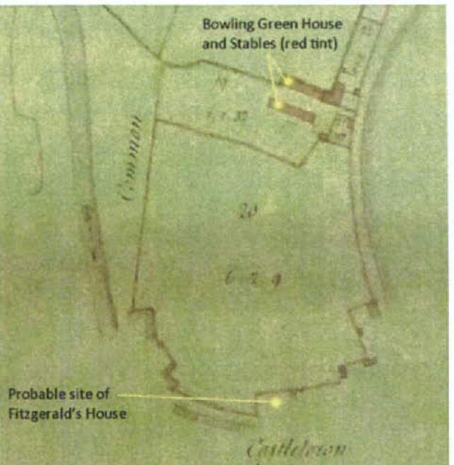
The first trustworthy map of the area is that of the Bowling Green Estate produced by John Corris in 1800, below, left. This records the land-holdings of John Taubman. The Taubmans had been selling off peripheral parcels of land and the map shows that by 1800 the relevant section of Bridge Street was outside the Bowling Green Estate (on map detail, below right: 'probable site of Fitzgerald's House').
The Corris Map, 1800 (Plan and Survey of the Bowling Green Estate). Detail from the Corris Map. The present Lorne House occupies most of Fields 19 and 20.
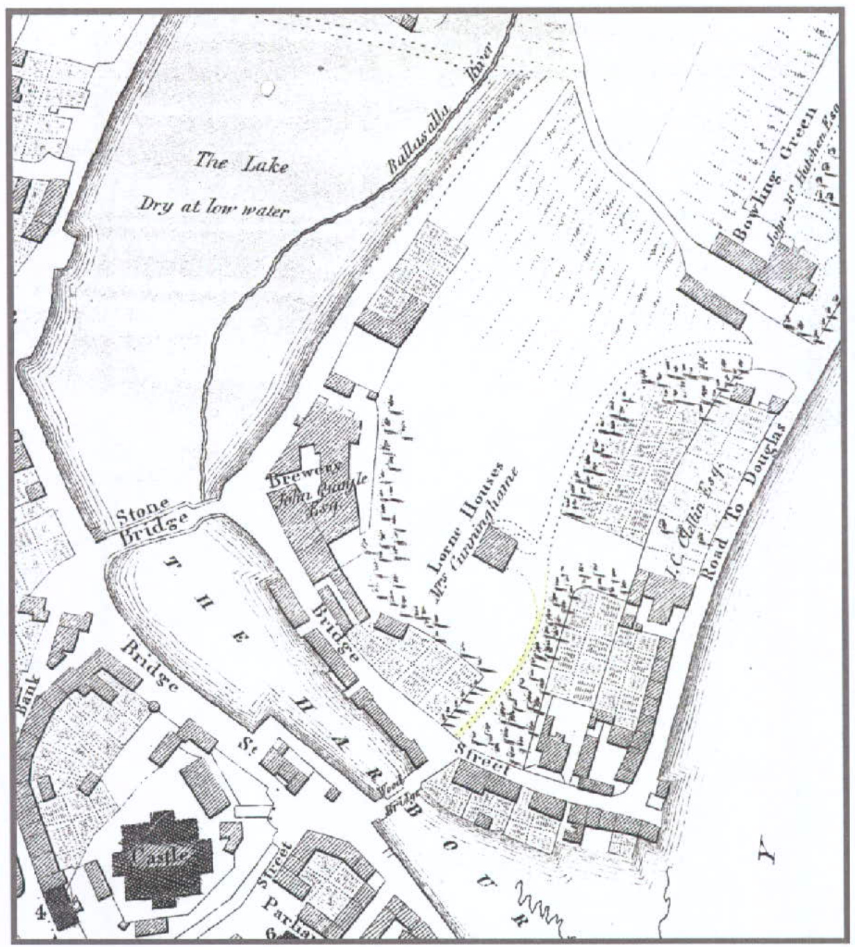
By 1827, however, both Fitzgerald's House and most of Fields 19 and 20 were owned by Robert Cuningham. He appears to have demolished Fitzgerald's House when Lome House was built, but to have, initially, retained the entrance to that property off Bridge Street, using it, initially, as a through carriage drive linking Lome House to both Bridge Street and the former Bowling Green Stables (now part of Lome House) and the link via what is now Pickard's Close to Douglas Street.
This is deduced by comparing the Corris Map with that produced in 1833 by John Wood (not James Wood, of Woods Atlas, whose maps are not helpful in this respect). John Wood was a surveyor from Edinburgh. His map of Castletown (below, with detail overleaf) appears in the top left-hand corner of his 1833 map of Douglas. The map's date can be confirmed by the reference to the occupier of the house - Margaret Cuningham (Robert's widow). The house was in her name between June 1832, when Robert died, and July 1834, when she died.
Map surveyed and drawn by John Wood, Surveyor, of Edinburgh. This map appears on the top left-hand corner of John Wood's 1833 map of Douglas, MNH ref. pDG, I.L.
Detail from 1833 Map of Castletown by John Wood, with the drive extension coloured yellow.
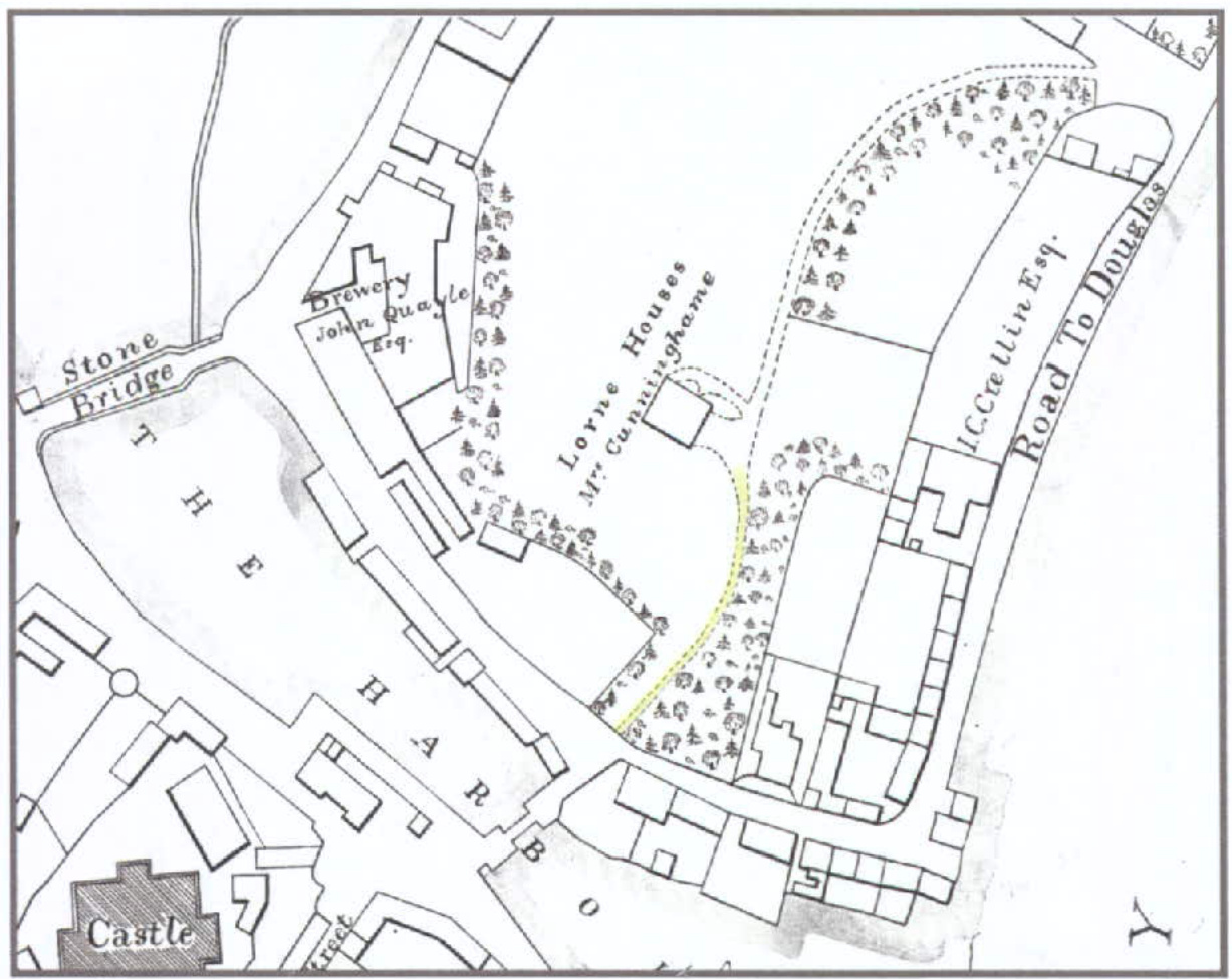
This map was copied by GJH Neely a century later, when he was President of the Isle of Man Natural History and Antiquarian Society (page 5). In 1932, his Presidential Address to the Society was on the topic of 'Early Maps of the Isle of Man' and there are other articles by him on other aspects of mapping. Neely's map clearly reproduces the drive extending fluidly to Bridge Street and seems to have been an academic exercise to plot land ownership in 1833.
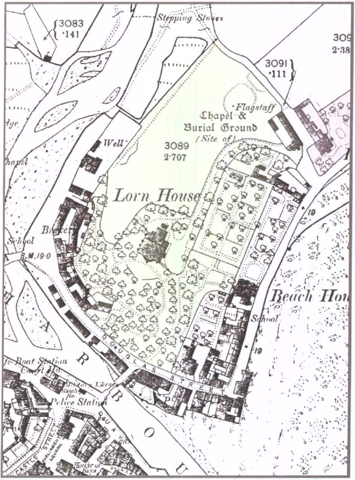
By the time of the Ordnance Survey map in 1878, the route's clarity had become confused by the pattern of shrubbery and paths that had probably been laid down by Lieutenant Governor Ready, who moved into the house in 1834 (overleaf). At some very early stage, the decision must have been taken to downgrade the carriage drive south of Lome House to a footpath, with a standard width gate onto
Bridge Street, most probably to enhance privacy. Evidence for a wider entrance remains, however, in a gatepost set into the garden wall, and in the remains of a contoured bank along one side of the wider wall (photographs, pages 5 and 6).
Detail from the Ordnance Survey map of 1878 showing Lorne House. Note that on this map, Bridge Street is labelled Douglas Street.
Extract from GJH Neely's map of Castletown in 1833, probably produced circa 1930. He enlarged it from the inset plan of Castletown, on John Wood's map of Douglas.
Photograph of boundary wall on Bridge Street. The gatepost is marked by the pink arrows. The three other sections arrowed appear to show three different work areas. The gatepost does not relate to any wall behind it.
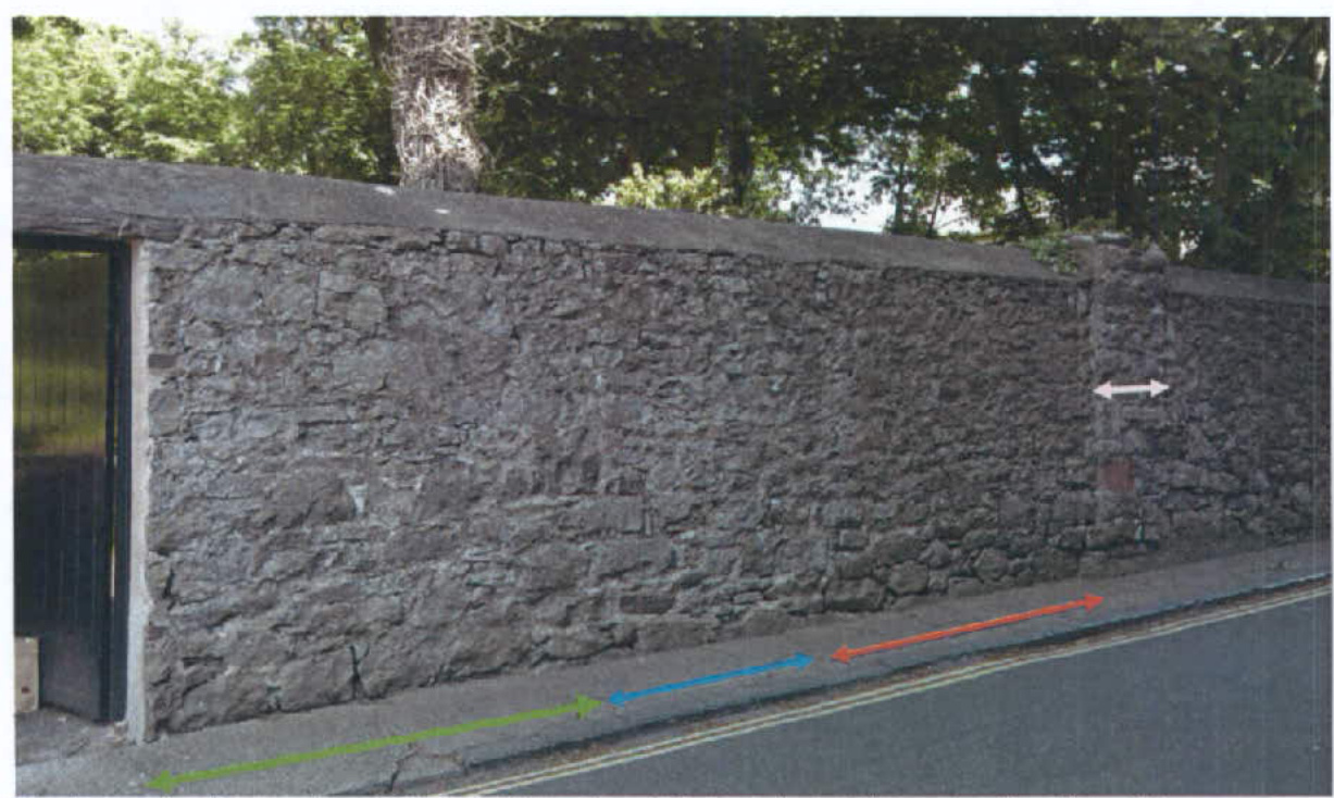
To the left of the gate, there is some reconstruction (red arrow), probably relating to the work on the pavement (white arrow - for the water mainl). The section with the yellow arrow appears to be all reconstructed.
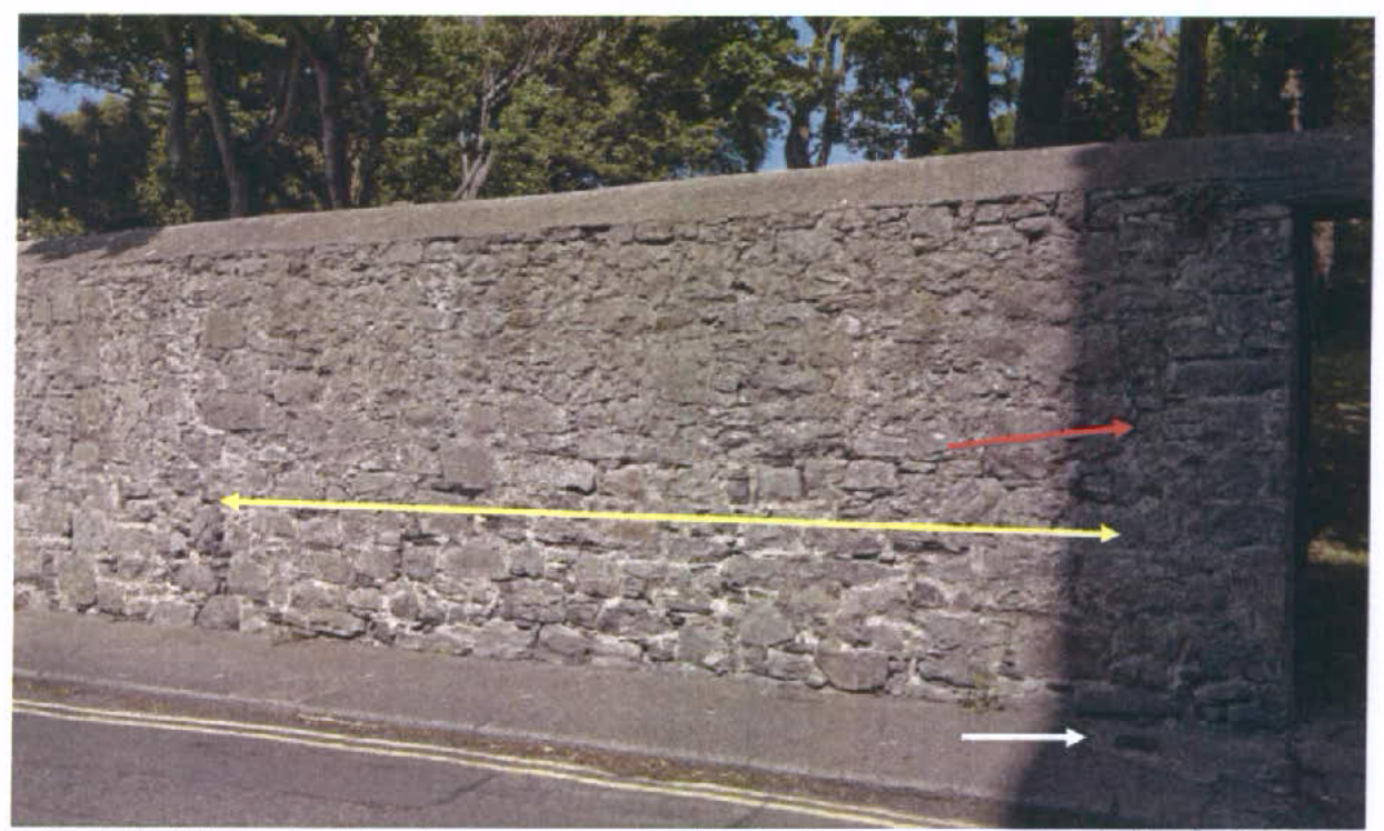
On the garden side of the wall, the bank to the right of the gate (arrowed), which tapers back to the right foreground, could well be the original line of the driveway.
There is clear evidence that:
There is thus ample precedent for a road access from Bridge Street to Lorne House.
Patricia A Tutt 14 June 2010
Tutt, Patricia (2010/a) Lorne House, a Manx survivor. Ramsey: Lily Publications. Tutt, Patricia (2010/b) Lorne House, a Manx mansion and its history. Unpublished academic paper.
MAPS Corris, John (1800) Plan and Survey of the Bowlingreen (sic) Estate in the Parish of Malew belonging to Major Taubman. MNH
Ordnance Survey, 1878. MNH Wood, John (1833) Plan of Douglas, Isle of Man, from Actual Survey. By John Wood, Surveyor, Cannan Grove, Edinburgh. Sheet 26 in. by 35 in. This Plan also contains a Plan of Douglas Bay and Harbour, with Sir William Hillary's Breakwater, 1826 and a Plan of Castletown. MNH
PHOTOGRAPHS Patricia Tutt, 10/06/2010
Copyright in submitted documents remains with their authors. Request removal