PLANNING STATEMENT IN SUPPORT OF THE ERECTION OF AN AGRICULTURAL BUILDING AND ASSOCIATED HARDSTANDING, BALLIG FARM, WEST BALDWIN, BRADDAN
1.0 Introduction
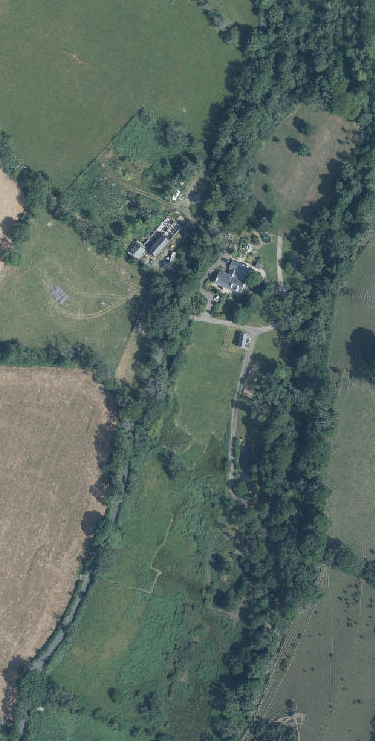
1.1 Ballig Farm comprises approximately 5 hectares (12 acres) of agricultural land and a residential curtilage. The site accommodates a complex of existing buildings including a dwelling and smaller outbuildings all situated on the eastern side of the B22 West Baldwin Road. The site lies between the road and the West Baldwin River/ River Glass which runs from Injebreck Reservoir to join the River Dhoo at the National Sports Centre, becoming the River Douglas and flowing out to the sea at Douglas Harbour.
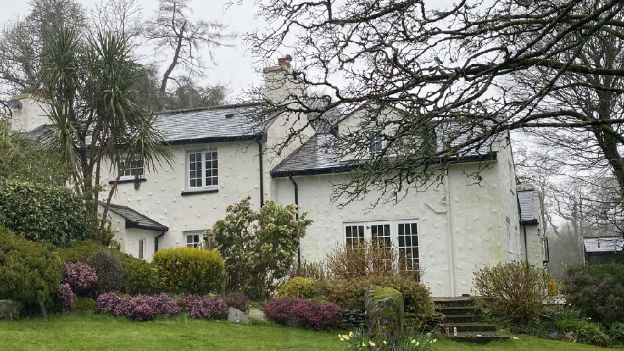
1.2 The house on the site is a former Manx cottage which has been extended over time. The original cottage has two chimneys and faces south and has been extended eastwards towards the river as well as backwards to the north, with a link to a single garage with accommodation at the rear.
A photograph showing a white, two-story detached house with a slate roof and a garden featuring shrubs and trees.
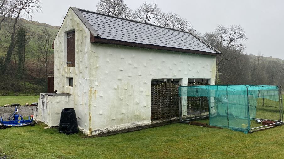
1.3 There is parking around the house for a number of vehicles. There is also a detached outbuilding which sits to the south east of the house.
1.4 There is a small shed and greenhouse to the north of the house.
A photograph of a white agricultural building with a slate roof and a green mesh enclosure attached to the side in a rural setting.
1.5 The site extends to the north and south of the building group in the form of gently sloping agricultural land which borders the river.
1.6 Access into the site is through a newly formed entrance (24/00170/B) which is an additional access to the south of the original entrance into the site.
1.7 On the western side of the road, slightly higher than Ballig Farm, are farm buildings which are in the process of being converted to a dwelling.
2.0 Planning Policy
2.1 Area Plan for the East
2.1.1 The site lies within an area designated on the Area Plan for the East as not for a particular purpose. Essentially this means that the site is not designated for development and is considered to be part of the countryside.
2.1.2 On the Environmental Constraints Map 1a the area where the buildings are is identified as Registered Trees with the field to the north included in its entirety. The field to the south is, however, undesignated with the Registered Trees around the perimeter. This is different to what is shown on the Island Environment mapping (below right) which shows the northern field as undesignated for Registered Trees and no trees along the river although there are Registered Trees alongside the road beside the field. There are no protected wildlife sites or sites of ecological interest highlighted on either map.
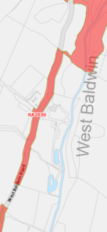
A site location map showing a red highlighted area along West Baldwin road, indicating the proposed agricultural development site.
2.1.3 There are no Infrastructure Constraints shown for the site on Map 1b nor Community Constraints shown on map 1c.
2.1.4 When planning policy was first introduced in a map form, the Isle of Man Planning Scheme (Development Plan) Order 1982 contained areas of an area of High Landscape or Coastal Value and Scenic Significance in which this site sat. These have been replaced in the Area Plans by the designations and guidance in the Landscape Character Assessment 2008. Here, the site lies in an area of the West Baldwin Narrow Upland Glen. The advice in the Area Plan for the East for this area is as follows and the full text from the original document is set out in Appendix Two:
Landscape Character Area West Baldwin (B7) Landscape Strategy Conserve and enhance:
a) the character, quality and distinctiveness of the valley with its dense deciduous woodland in lower valley bottom;
b) the traditional character of West Baldwin Village;
c) the rural and tranquil character of the valley;
d) the open views across the West Baldwin Reservoir to the surrounding upland areas.
Key Views Enclosed views from the valley bottom. Glimpsed views between vegetation up the valley to the upland areas. Open views across the West Baldwin Reservoir. Glimpsed view of St. Luke’s Church.
Landscape Proposal 3 (West Baldwin) To preserve the character of West Baldwin village any application for planning approval must demonstrate that consideration has been given to scale, location and design of development in order to protect and enhance the village and its setting and that the proposed development can mitigate adverse effects.
Landscape Proposal 4 (West Baldwin) Any development that would be visible from the West Baldwin Reservoir must be so designed so as to integrate well into the landscape showing sensitive design towards its setting. Colours, materials and finishes must be of a nonreflective and complementary nature.
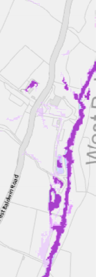
2.1.5 The site is shown on the national flood risk maps as having small areas at risk of surface water flooding, associated with the River Glass (see right).
2.1.6 The site is not within a Conservation Area and does not contain any Registered Buildings.
2.2 Strategic Plan
2.2.1 The Strategic Plan presumes against development in undesignated areas and generally directs new building towards existing settlements. There are exceptions to this (General Policy 3) including development which is essential for the conduct of agriculture. Further advice is provided in this respect in Environment Policy 15:
Environment Policy 15: Where the Department is satisfied that there is agricultural or horticultural need for a new building (including a dwelling), sufficient to outweigh the general policy against development in the countryside, and that the impact of this development including buildings, accesses, servicing etc. is acceptable, such
development must be sited as close as is practically possible to existing building groups and be appropriate in terms of scale, materials, colour, siting and form to ensure that all new developments are sympathetic to the landscape and built environment of which they will form a part.
Only in exceptional circumstances will buildings be permitted in exposed or isolated areas or close to public highways and in all such cases will be subject to appropriate landscaping. The nature and materials of construction must also be appropriate to the purposes for which it is intended.
Where new agricultural buildings are proposed next to or close to existing residential properties, care must be taken to ensure that there is no unacceptable adverse impact through any activity, although it must be borne in mind that many farming activities require buildings which are best sited, in landscape terms, close to existing building groups in the rural landscape.
2.2.2 There is a presumption against development which would itself be at risk of or would increase the risk of flooding elsewhere (Environment Policies 10 and 13).
2.2.3 Development which would result in the loss of trees of amenity value is presumed against (Environment Policy 3).
2.2.4 Development which would adversely affect ecology is presumed against (Environment Policies 4 and 7) and development is now expected to result in at least no nett loss of biodiversity but ideally a biodiversity nett gain (Residential Design Guide).
2.2.5 The most versatile agricultural soils are protected thus:
Environment Policy 14: Development which would result in the permanent loss of important and versatile agricultural land (Classes 1-2) will not be permitted except where there is an overriding need for the development, and land of a lower quality is
not available and other policies in this plan are complied with. This policy will be applied to
(a) land annotated as Classes 1/2 on the Agricultural Land Use Capability Map; and
(b) Class 2 soils falling within areas annotated as Class 2/3 and Class 3/2 on the Agricultural Land Use Capability Map.
2.2.6 The land here appears to be Class 3.
2.2.7 The countryside is protected for its own sake and development which would have a harmful impact is presumed against (Environment Policy 1, Strategic Policies 4 and 5).
3.0 Planning history and relevant applications
3.1 The site has been the subject of the following applications:
96/01133/B - installation of dormer window, new uPVC windows and French doors and replacement of roof - permitted (no documents available online)
97/00881/B - Erection of cattle shed, log store and creation of two wildlife pond permitted (no documents available online).
97/01294/B - Alterations to existing vehicular entrance to dwelling and relocation of vehicular access to nearby fields - permitted (no documents available online)
02/01988/B - extension to dwelling - permitted (no documents available online)
03/01511/B - amendments to approved extension (02/01988/B) - permitted (no documents available online)
07/02250/R - retention of alterations to dwelling - permitted.
24/00170/B - creation of additional access to improve site access - permitted. The applicant confirmed in the application form that the current access provides the owner with difficulties accessing the site with larger farm vehicles.
24/00796/B - erection of agricultural building - withdrawn. This application generated comments from:
• The Highway Services Division of Department for Infrastructure had no objection to the application
• The Highway Services Division of Department for Infrastructure Drainage initially submitted a comment indicating that there is no information on the access to the field. The applicant confirmed that “On this application we proposing to extend into the field a hardcore access with this track being many meters below and well away
from the highway no contact or connection with the highway. The hardcore track is permeable with the concrete turning area being the only new hard surface outside the buildings entrance doors.” On this basis the Department indicated that they had no objection.
• Braddan Parish Commissioners had no objection
• Andy Cooper, whose job title is not provided in his correspondence to the planning officer but who is understood to be an agricultural adviser in Department of Environment, Food and Agriculture, was approached by the planning officer and he made a range of comments about the amount of manure and urine which would be generated by the number of animals in the proposed building but which was not addressed in the application and also that there was no provision for the storage of the amount of straw required for bedding. He also commented on feed passages and queried the ownership of land said in the application to be owned by the applicant and whether the applicant was registered and supporting the application.
Development on the western side of the road
3.2 This site has permission for conversion and extension of the existing buildings to form a single dwelling with garage.
Other development along West Baldwin Road
3.3 There has been permission granted for agricultural buildings along the West Baldwin Road: 12/01602/B, 87/00214/B, 11/00404/B.
4.0 The proposal
4.1 The application is a resubmission of the application which was withdrawn 24/00796/B - and this application seeks to address the issues raised.
4.2 The application proposes the erection of a new agricultural building situated to the north of the existing farmhouse. The building will have a footprint of 20m by 40m including a straw bale store against the northern elevation of the structure and an area for the external storage of silage bales on the western side of the building.
4.3 The building will have an eaves height of 5m and an overall height of 8m. The building will be finished in a combination of sheeting, timber boarding and stonework with a 1.8m high stone plinth on the west, east and southern elevations with the northern elevation finished in timber boarding. The roof will be finished in green sheeting.
4.4 A concrete apron will be formed around the building, extending to 18m to the west (towards the road), 5.5m to the north, 5.2m to the east (towards the river) and
8m to the south (towards the house).
4.5 Two subterranean slurry tanks will be introduced underneath the hardstanding to the south of the building. Drainage pipes will collect rain and surface water from the building to discharge into the river via a protected outfall.
4.6 Internally the building will have a central aisle either side of which will be cattle holding stalls
Justification
4.7 The site is the applicant’s residence and it is his wish to have a building on this site to accommodate his cattle stock over winter. There is some agricultural land available on this site but the majority of the holding is located elsewhere with 92 acres owned off the Staarvey Road and a further 9 acres owned at Sulby. Details of these holdings are provided in this application. Neither of these sites have any buildings on them.
4.8 The applicant is a registered farmer with Department of Environment, Food and Agriculture with a holding number - 282. He currently has 80 head of cattle and 25 young cattle but no buildings of his own to accommodate them. There is sufficient storage space within existing structures at Ballig to accommodate the telehandler for bale handling and grass toppers and equipment needed for management of the holding.
4.9 The Strategic Plan is clear that new agricultural buildings should be sited as close as possible to existing building groups and not sitting as isolated buildings in the countryside. In this case, the applicant’s other land does not contain any buildings and the only land with buildings on it where a new agricultural building could be said to be part of an existing group and served by the same access as the existing building, is at Ballig.
4.10 The applicant has taken on board the comments made previously regarding drainage, slurry and animal waste and has incorporated facilities for these within the development.
4.11 The applicant has also liaised with the Flood Risk Team to add to the early correspondence which took place with the Flood Risk Team we would reinforce with the following:
• Due to the open nature of the proposed structure, if flooding should occur, flood waters would be readily able to pass through the structure and therefore would not result of a loss in volume to the flood plain itself.
• The proposed floor slab level 115.00 is approx 2.0m above the bank level opposite 113.30 and any new electrical systems, sockets, fuse board or switches etc would be situated at a higher level (suggest minimum 1.8 m above floor level) to give protection should the structure be subject to a rise in water levels.
• The bank to the river would not be fenced or walled, preventing potential trapping of any river materials passing downstream at the rivers edge.
4.12 The cattle will be overwintered on the site although there is some land for outside grazing should the weather permit. It is likely that the animals will be kept in over the winter which is common practice on the Island. The route which the animals will use to access the external grazing area is shown on drawing 07.
4.13 The building will be sited below the level of the road and screened to some extent by the roadside trees. One Category C tree group (black willow) is to be removed as part of the development and an Arboricultural Impact Assessment is provided which confirms this and shows how the remaining trees, some of which are Registered, will be protected from damage during the implementation of the development.
4.14 There are a number of Category U trees to the south and west of the proposed building which are dead or in poor condition and are recommended for removal regardless of the application. These are mostly ash with a beech, sycamore and elm. Whilst their removal is not necessitated by this application, in the interests of good arboricultural management of the site, a replanting scheme will be implemented for any trees lost, incorporating two new trees for every one lost and using Turkey oak, alder and silver birch, details of which are provided in the application, for information. Therefore if any trees are removed alongside the highway, they will be replaced with new trees which, in time will continue to provide a visual screen of the view of the field and proposed building, from the highway.
4.15 The building will not be conspicuous or prominent in view from any existing residential properties and is not sufficiently close to any residential property to create any adverse impact through noise, activity or smell. The closest residential property to the proposed building is the applicant’s own dwelling.
4.16 The proposed building will enable the applicant’s land to be effectively and efficiently managed, providing an overwintering shelter for the cattle and in a location
close to existing buildings. As stated earlier, there are no buildings on the other parcels of land and a new building there would represent an isolated building which is contrary to the advice provided in Environment Policy 15.
4.17 Whilst the proposal will result in the loss of grazing land, the building will be used for agricultural purposes and will enable the remainder of the agricultural land to be used more productively. The soil is understood to be Class 3 and therefore not specifically protected for its own sake.
4.18 We believe that this proposal, whilst for a sizeable building, is justified in agricultural terms. We also believe that considering the accompanying information, that the proposal will have an acceptable impact on the environment, both in terms of visual impact (General Policy 2, Environment Policy 1 and Strategic Policies 4 and 5), flood risk (General Policy 2, Environment Policies 10 and 13), drainage and animal welfare. It would not have an unacceptable impact on existing trees of amenity value (Environment Policy 3) and would not harm wildlife (Environment Policies 4 and 7) or result in the loss of the most versatile agricultural soil (Environment Policy 14) and is therefore in accordance with all of the relevant planning policies and not harming the landscape, in accordance with the recommendations of Landscape Character Assessment.
Sarah Corlett 08.04.25
Appendix One
Landscape Character Assessment B7 – WEST BALDWIN Key Characteristics
• Steep sided V-shaped valley.
• Various smaller tributaries.
• Dense deciduous woodland in valley bottom.
• West Baldwin Reservoir and associated features.
• Coniferous plantations.
• Heathland vegetation on steeper slopes upstream.
• Strong geometric field pattern on valley slopes downstream.
• Narrow sometimes steep B22 road with Manx hedges, mature trees and stone walls lining its path around the reservoir.
• Scattered whitewashed houses along valley bottom road.
• Traditional small settlement of West Baldwin at a river crossing point near the mouth of the valley.
• Remote rural and tranquil feel, bolstered by the surrounding open expanse of the upland areas and large expanse of water at West Baldwin Reservoir.
• Enclosed views from the valley bottom with more open views further up the valley to the surrounding upland areas.
• Ard Whallin Outdoor Pursuits Centre, which provides fishing/sailing facilities.
Overall Character Description The River Glass descends from the upland area below Injebreck Hill and Carraghan down into the Incised Inland Slopes north of the settlement of Baldwin and has cut a steep sided V-shaped valley along its course. Tributaries of a variety of sizes, including that in the relatively large wooded Awin ny Darragh Valley, the steep sided Colden River and smaller water bodies in culverts, join the valley at various points along its course. The Colden River is surrounded by the Colden coniferous plantation.
Dense deciduous woodland covers much of the valley bottom in the lower part of this valley with grazing paddocks, wet meadows and lush riparian vegetation alongside the river. Rectangular pastoral fields, on the gentler valley sides of the lower valley, peter out upstream as the field patterns fragment and large, blocky coniferous plantations, rough grass, areas of bracken and gorse grow on the steeper slopes that ascend to the Upland areas.
The road corridor is enclosed by grassy Manx hedges and mature hedgerow trees, while Manx hedges with gorse form the majority of the field boundaries on the valley sides lower down the valley. Field boundaries are overgrown or lost in the upper reaches of the valley. A mature avenue of beech trees lines the road around the estate of Injebreck House.
Various houses and many that contain ornamental garden species that have a whitewash render or are built of Manx slate stone are clustered along the valley bottom road. Stone bridges cross the B22 at West Baldwin while some farms with associated outbuildings, such as Ballakewish, are located on the valley slopes and surrounded by deciduous trees.
The extensive West Baldwin Reservoir is dammed with a graded grass slope to the south, has peripheral slate stone walls alongside the B22 and has its eastern periphery fringed by mature waterside trees. This large expanse of water, the lack of substantial settlement in the area and the expanse of the surrounding uplands create a relatively remote and tranquil character. This sense of tranquillity can be interrupted at times by parked vehicles, traffic and other activity associated with recreational uses on or near the reservoir.
Key Views
• Enclosed views from the valley bottom
• Glimpsed views between vegetation up the valley to the upland areas
• Open views across the West Baldwin Reservoir
• Glimpsed view of St. Luke’s Church
Historic Features
• Turn of the century Manx Slate stone houses in Baldwin
• Disused quarry
• Monument marking original site of Tynwald Hill
• Site of St. Luke’s Church (Registered Building)
Ecological Features
• Aquatic and waterside habitats
• Upland heather moorland habitats
• Marginal farmland habitats
• Hedgerows with high biodiversity
Evaluation of landscape sensitivities
• Dense mature deciduous woodland along the valley bottom and lower slopes.
• Remote, rural and tranquil character.
• Strong regular pastoral field patterns on lower slopes.
• With exception of traditional nucleated village of West Baldwin, sparse settlement in the valley.
• Dense riverside woodland and vegetation.
• Ecological value of the aquatic ecosystem of the West Baldwin Reservoir and riparian habitats.
• B22 enclosed by grassed Manx hedges with vegetation and overhanging trees growing on top in some sections.
Landscape Strategy The overall strategy for the area should be to conserve and enhance the character, quality and distinctiveness of the valley with its dense deciduous woodland in lower valley bottom, the traditional character of West Baldwin Village, the rural and tranquil character of the valley and the open views across the West Baldwin Reservoir to the surrounding upland areas.
Copyright in submitted documents remains with their authors. Request removal
Source & Provenance
Official reference
25/90379/B
Source authority
Isle of Man Government Planning & Building Control