Planning Statement In Respect Of The Application For Approval Of The Reserved Matters Relating To 23/01360/A - Approval In Principle For The Redevelopment Of The Site To Provide Cafe, Bowling Clubhouse, Community Facilities And Public Toilets; Tennis Courts, Marine Parade, Peel
1.0 Introduction
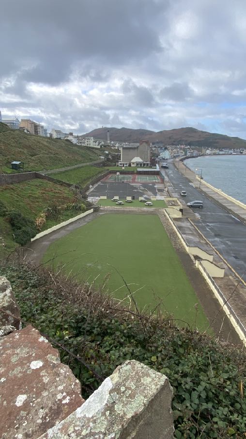
1.1 The site is an area of originally two but more recently one public tennis court situated on the south eastern side of Marine Parade at the north eastern end of Peel’s promenade (Shore Road). The site has a frontage of approximately 35m and a depth - front to back - of 29m - an area of 1,015 sq m.
1.2 The site sits within a wider area of land and community facilities owned by Peel Town Commissioners: to the south west is the existing cafe, bowling green, public toilet block and club house and to the north east is a hard surfaced, multi sport area incorporating basketball nets and formerly a skateboard/BMX park. Beyond that is the former swimming pool which is now an artificial grassed area with picnic tables and chairs. This overall area amounts to approximately 8,734 sq m all within the ownership and management of the local authority with a further 27,550 sq m of brooghs and play area to the south and east, all accessible by public paths which wind along the brooghs and step down across the site and abut the swimming pool, multi sport area court and bowling green.
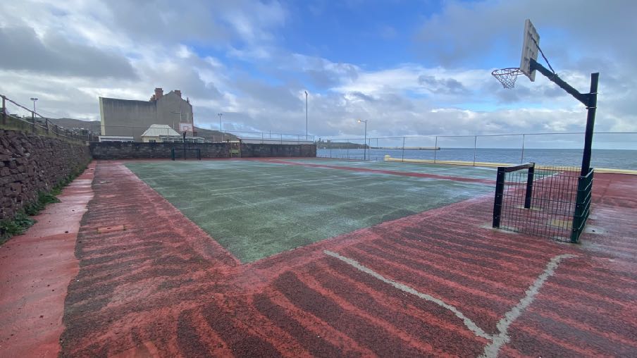
1.3 The site presently accommodates one hard surfaced tennis court and a multi sport court area which have higher boundary fencing alongside the highway. Both the tennis court and the multi sport area together with the games area back onto a grassed lane on top of a
sandstone wall at the rear which provides access to the bowling green which sits alongside the tennis courts. The tennis court currently has no net: it is installed every year around May and removed at the end of the summer. The skateboard equipment has been removed due to its poor condition (rusting). To the north east is a flat artificial grassed area where there are benches and tables.
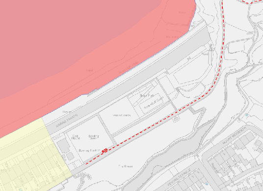
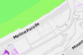
1.4 Public access runs through the wider site (PROW 506 - Walpole Road to the Headland the red dotted line on the plan right which runs between the multi sport area and the artificial grassed area) and to the broogh area to the south which rises to join Peveril Terrace and Mount Morrison which sit 79m from the nearest point of the site and considerably higher.
1.5 The pink area in Peel Bay on the map right denotes the West Coast Marine Nature Reserve and the yellow area the north eastern extent of the adopted Peel Conservation Area. The site is outside both of these.
1.6 The Commissioners have invested heavily in the Swimming Pool and Campsite areas on Derby Road and have made representations to the Area Plan for the North and West to have the remaining undeveloped land adjacent to Ballaquane Road re-designated as Public Open Space to replace that which could be lost as a result of the expansion of the Peel Clothworkers’ School which will support the growth of the town (see Planning Policy Context later). They are also looking to expand the playground facilities at West View and leisure use on the Headlands Field.
1.7 They advise that the skate park required major refurbishment and one of the pieces of equipment was fenced off in 2022 to prevent its use and it and the other jumps have since been removed and the Commissioners are considering relocating this facility to a less exposed location. The existing equipment has historically been damaged and subject to premature degradation due to the exposure to a high salt coastal environment.
A site location plan showing the application site boundaries, surrounding roads like Ballagarey Road, and adjacent land use zones.
2.0 Planning policy context Peel Local Plan
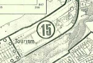
2.1 The site lies within an area designated on the Peel Local Plan of 1989 as Tourism:
2.2 The site lies outside of the town’s Conservation Area which ends just before the bowling green. There are no buildings - Registered or otherwise - on the site, nor trees - Registered or otherwise and the site is not at risk of flooding according to the national flood risk maps.
2.3 The Written Statement accompanying the Peel Local Plan map refers specifically to this site, stating, “Part of the Marine Parade Area has already been approved for hotel use and some of the adjoining open space will be required to complete the development.”
2.4 The Plan identifies the “principal open space areas” as Peel Hill, the Headlands and former bowling green, putting green and miniature golf course, the eastern coastal area bounded by Ramsey Road and the camp site on Derby Road and there is a general statement at paragraph 13.2 that open space areas within the town will generally be
A black and white excerpt from a topographical map or site plan showing land boundaries, hatched fields, and the label 'Tourism'.A cropped section of a site location map showing the road 'Marine Parade' and surrounding plot boundaries.
safeguarded from development, particularly identifying Peel Hill for such protection as well as the eastern coastal area bounded by the Ramsey Road.
2.5 Under “Tourism and Transport” it simply states: “It should be noted that an approval exists for a hotel development on the site of the swimming pool on the East of Marine Parade”.
2.6 It also notes that it was anticipated at the time that tourism will become increasingly important to the economy of Peel and will exert pressure on the fabric of the town but that it is essential that the integrity of the town is retained and that any such development is sympathetic to and compatible with the overall environment of the town (paragraphs 4.11 and 4.12).
Isle of Man Strategic Plan 2016
2.7 The starting point in the assessment of any planning application is the land use designation in the adopted local or area plan. If the development is in accordance with that designation, which this is, the Strategic Plan, General Policy 2 is applicable, stating:
“Development which is in accordance with the land-use zoning and proposals in the appropriate Area Plan and with other policies of this Strategic Plan will normally be permitted, provided that the development:
(a) is in accordance with the design brief in the Area Plan where there is such a brief;
(b) respects the site and surroundings in terms of the siting, layout, scale, form, design and landscaping of buildings and the spaces around them;
(c) does not affect adversely the character of the surrounding landscape or townscape;
(d) does not adversely affect the protected wildlife or locally important habitats on the site or adjacent land, including water courses;
(e) does not affect adversely public views of the sea;
(f) incorporates where possible existing topography and landscape features, particularly trees and sod banks;
(g) does not affect adversely the amenity of local residents or the character of the locality;
(h) provides satisfactory amenity standards in itself, including where appropriate safe and convenient access for all highway users, together with adequate parking, servicing and manoeuvring space;
(i) does not have an unacceptable effect on road safety or traffic flows on the local highways;
(j) can be provided with all necessary services;
(k) does not prejudice the use or development of adjoining land in accordance with the appropriate Area Plan;
(l) is not on contaminated land or subject to unreasonable risk of erosion or flooding;
(m) takes account of community and personal safety and security in the design of buildings and the spaces around them; and
(n) is designed having due regard to best practice in reducing energy consumption.”
2.8 Other policies encourage the optimal use of undeveloped and under-developed sites and the promotion of sustainable development (see Appendix One).
2.9 Whilst the site is not within a Conservation Area, it is close to it so Environment Policy 36 is applicable:
“Environment Policy 36: Where development is proposed outside of, but close to, the boundary of a Conservation Area, this will only be permitted where it will not detrimentally affect important views into and out of the Conservation Area.”
2.10 Environment Policy 43 explains that the Department will generally support proposals which seek to regenerate run-down urban and rural areas. Such proposals will normally be set in the context of regeneration strategies identified in the associated Area Plans. The Department will encourage the re-use of sound built fabric, rather than its demolition. This echoes Strategic Policy 1 which encourages the optimisation of the use of unused and under-used land.
2.11 The Tourism Chapter explains that the Strategic Plan supports the growth of employment opportunities (Business Policy 1), and explains that some tourism facilities do not require permanent development and explains that a balance needs to be struck between the needs of tourism and the protection of the very assets which attract tourists to the
Island in the first place - its unique landscape, culture and heritage. It welcomes “new forms of contemporary tourism development” (paragraph 9.5.5) and that it is more likely than the traditional Victorian hotel, that tourist accommodation demands are met through the designation of specific tourist attractions and large individual hotel sites with “new tourist accommodation incorporated into areas of mixed or residential use”.
2.12 Chapter 10 of the Strategic Plan sets out the acknowledged importance and benefit of open space and leisure and recreation facilities, recommending that area plans assess the needs of the plan area in terms of sport and recreation and identify land uses in accordance with those findings. It also states:
“10.3.5 In certain circumstances it may be beneficial to allow the redevelopment of areas of underused, poorly maintained or inappropriately located open space. Development on such areas will only be permitted where alternative provision can be made. However, the new open space must be easily accessible to the local community and be at least equivalent in terms of type, quantity and quality to that which is being replaced.
Recreation Policy 2: Development which would adversely affect, or result in the loss of Open Space or a recreation facility that is or has the potential to be, of recreational or amenity value to the community will not be permitted except in the following circumstances:
(a) where alternative provision of equivalent community benefit and of equivalent or better accessibility is made available; and
(b) where there would be an overall community gain from the development,
and the particular loss of the open space or recreation facility would have no significant unacceptable effect on local open space or recreation provision or on the character or amenity of the area.”
2.13 The only definition of Open Space that we have been able to find is that within the Isle of Man Planning Scheme (Development Plan) Order 1982 Written Statement where it states that this is “any land, whether enclosed or not, on which there are no buildings or on which not more than one twentieth part is covered with buildings”.
2.14 The Strategic Plan sets out standards for the provision of car parking, suggesting that in the case of town centre retail use (there are no specific standards for cafes), spaces should be provided for service vehicle use and for assembly and leisure, one space per 15 sq m gross floor area should be provided, although this standard may be relaxed where development
“(a) would secure the re-use of a Registered Building or a building of architectural or historic interest; or
(b) would result in the preservation of a sensitive streetscape; or
(c) is otherwise of benefit to the character of a Conservation Area.
(d) is within a reasonable distance of an existing or proposed bus route and it can be demonstrated a reduced level of parking will not result in unacceptable on street parking in the locality.”
(Transport Policy 7 and Appendix Seven).
Area Plan for the North and West
2.15 Whilst progressing towards the adoption stage, the Plan is still in draft form. A Call for Sites having been made by Cabinet Office after which a draft plan was published for comment and responses received. This was published in June 2022 and whilst the draft plan suggested that it would be the subject of a public inquiry in the Spring of 2023, this did not occur until July 2024 prior to which a series of modifications to the draft plan was published and subject to consultation.
2.16 The draft plan which defines the settlement boundaries at this stage shows the site being within Peel’s settlement boundary and was not modified prior to the public inquiry in this respect. It designated the area presently shown as Tourism, as Open Space which is part of the wider area of Open Space incorporating the brooghs to the rear and the headlands and play area to the east. The Written Statement which accompanied this included the following Proposal specifically applying to this site and surrounding area:
Open Space and Community Proposal 2: Site PO007 on the northern end of Peel Promenade is recognised as important recreation and leisure space. Opportunities to enhance these facilities or introduce new compatible uses that would not detract from the primary use of the site for recreation and leisure
space will be considered on their merits, taking into account overall scale, design and layout, traffic generation and other planning considerations.
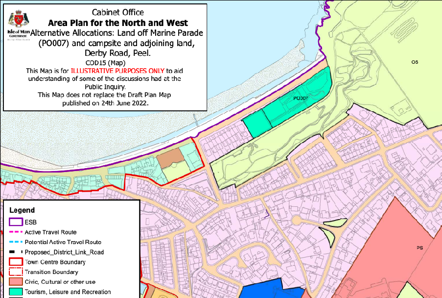
2.17 However at the public inquiry, during the discussion on Tourism and Public Open Space, the Cabinet Office agreed to amend the land use designation and the supporting Proposal to the following:
Cabinet Office Document 15 (COD 15) – Cabinet Office’s response to queries raised at the Inquiry regarding:
i. Land at Marine Parade (PO007) for tourism, recreation and leisure uses
This Cabinet Office Document has been produced in response to discussions had during the Public Inquiry, specifically the morning session on Friday 19th July 2024 which related to Matter 5 – Tourism and Leisure. During this session, Peel Town Commissioners (via their Planning Consultant) requested that land use proposals relating to land at Marine Parade (PO007) and the campsite off Derby Road be amended.
This document and the attached map COD 15 (Map) illustrate the proposed changes agreed on by both parties for consideration by the Inspector. The attached map is for illustrative purposes only and does not replace the Draft Plan Map for Peel dated June 2022.
i. Land at Marine Parade (PO007) – Proposed change to Tourism, Recreation and Leisure uses.
PIP 3 – Map 6 (published March 2024) showed land at Marine Parade (PO007) as Open Space, distinct from the wider area of Open Space at the Headlands. It was agreed at the Inquiry that Cabinet Office would further consider and confirm in writing its amended position.
Accordingly, Cabinet Office now puts forward for consideration:
COD 15 (Map) to replace PIP 3 – Map 6 (published March 2024) as far as it relates to PO007, land at Marine Parade as well as an amendment to Open Space and Community Proposal 2 of the Draft Written Statement (PIP 2) to read:
Open Space and Community Proposal 2
Site PO007 on the northern end of Peel Promenade is recognised as important existing and potential tourism, recreation and leisure space and will be retained for such uses. Opportunities to enhance these facilities or introduce new compatible uses that would complement the primary use of the site for tourism, recreation and leisure space will be considered on their merits, taking into account overall scale, design and layout, traffic generation and other planning considerations.
2.18 This document reiterates Peel’s place in the settlement hierarchy as a Service Centre where development will be concentrated outside Douglas.
A Cabinet Office Area Plan map illustrating land allocations and boundaries in Peel, highlighting tourism and leisure zones near the coast.
3.0 Planning history
3.1 Planning approval was granted in principle for the development of the site for a hotel under 88/01268/A and 87/00096/A which followed an earlier application for the principle of a hotel/conference/leisure complex which was refused on appeal having been approved on review (87/01100/A).
3.2 The Marine Hall which formerly existed on the north eastern part of the site was approved for use for pilot training under 86/01277/C. Permission was granted for the principle of a multi-use civic hall and recreational community facility to replace the hall under 11/00112/A.
3.3 None of the above applications was implemented nor reserved matters applications submitted.
3.4 A further application on the site which was approved on appeal was for the principle of a hotel leisure complex, residential apartments and parking spaces (05/01277/A) granted on 31.10.06. The inspector was not persuaded that there was sufficient information contained within the application to demonstrate that the development would be acceptable but the Minister determining the appeal was and the application was approved. No reserved matters application was submitted following this approval.
3.5 More recently an application was submitted for the development of a temporary tourist village on the site although this application was withdrawn prior to a decision being taken (21/01537/B).
3.6 Planning approval was sought for the additional use of the former swimming pool site (Class 1.3 Food and drink) as a pop-up lounge bar for 32 operating days from Fri 4th Aug -
Sun 3rd Sept with one week before installation from Fri 28th July to the opening on Fri 4th August and one-week de-rig from Monday 4th Sept to Monday 11th Sept (23/00650/C). This was permitted. The Planning Officer in his assessment of the application noted, “A concern is the temporary loss of the public open space area and what that might mean for the wider public. Given its temporary nature and in referencing to Recreation policy 2, this makes allowances through (b) where there is a community gain from the development, and the particular loss of the open space would have no significant unacceptable effect on the character or amenity of the area” and also
notes that the site would still be available for the public to use whilst the proposed use was undertaken.
3.7 This was the subject of a further application, 25/90235/C for the period 15th May - 14th September which is awaiting determination.
3.8 The most relevant application for the application site was one in principle for the redevelopment of the site to provide cafe, bowling clubhouse, community facilities and
public toilets. This application, 23/01360/A was initially refused but permitted on appeal subject to the following conditions:
1. Application for approval of the reserved matters shall be made to the Department before the expiration of two years from the date of this approval and thereafter the development shall only be carried out in accordance with the details as approved.
The development must be begun in accordance with the “reserved matters” as approved not later than the expiration of two years from the final approval of the reserved matters.
Reason: to avoid the accumulation of unimplemented planning approvals.
2. Approval of the details of siting, design, external appearance of the buildings, internal layout of buildings, drainage, and landscaping of the site (hereinafter called “the reserved matters”) shall be obtained form the Department in writing before any development is commenced.
Reason: to comply with the Town and Country Planning (Development Procedure) Order 2019.
3. Plans and particulars of the reserved matters referred to in condition 2 shall include details of;
a) the surface treatment of any hard surfaced external areas and there parts of the site which will not be covered by buildings;
b) all external materials (including roofs) to be used in the development;
c) existing and proposed ground and floor levels;
d) foul and surface water drainage (including storm water outfall and measures to precent surface water runoff from the site entering the public highway);
e) measures in the design which take into account the risk of coastal overtopping;
f) secure cycle storage for staff and visitors;
g) bin/recyclables storage facilities;
h) boundary treatments and
i) soft landscaping and planting - any trees or plants which within a period of five years from the completion of the development die, are removed, or become seriously damaged or diseased must be replaced in the next planting season with others of a similar size and species.
Reason: in the interest of the character of the area, to ensure adequate drainage, to take precautions against consider [sic] the risk of coastal overtopping, to ensure adequate bin storage and to promote active travel.
4. The Reserved Matters shall be accompanied by a Design Statement, which includes consideration of the site and surroundings and how the building will sit within the area as viewed from different public vantage points including from within the Conservation Area.
Reason: to comply with Strategic Policy 5.
4.0 The application
4.1 This application proposes the reserved matters from the approval in principle including all of the information required by conditions 3 and 4 of 23/01360/A permitted on appeal on 16.08.2024 other than full details of the proposed planting.
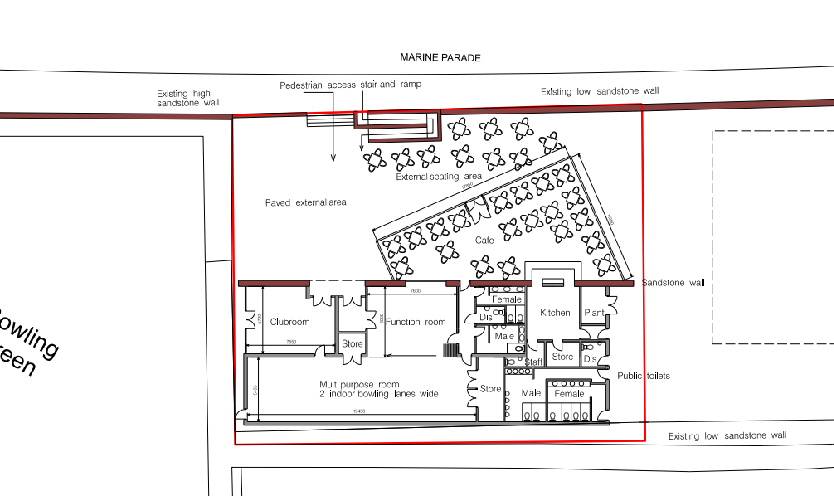
4.2 The approval in principle proposed a building in plan form as follows:
4.3 What is now proposed utilises the same concept as the original scheme, however the layout has been developed to create a strong sense of arrival for all building users, including improved accessibility for all users. The wall between the green and the site is to be removed and seating introduced alongside the building looking towards the bowling green.
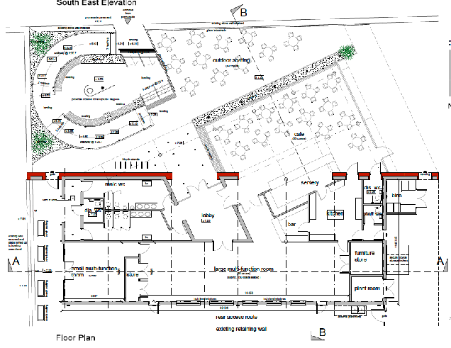
Architectural floor plan showing the internal layout of a bowling clubhouse and cafe with outdoor seating areas and pedestrian access.Architectural drawing combining a floor plan of internal rooms like a kitchen and bar with an outdoor seating layout.
4.4 The plans and supporting information provide the required information for all the matters referred to in the decision notice for the approval in principle, notably:
a) the surface treatment of any hard surfaced external areas and there parts of the site which will not be covered by buildings; hard surfacing is to feature dark and light grey sandstone for the seating areas and stepped entrance with resin bound gravel for the accessible curved ramp.
b) all external materials (including roofs) to be used in the development; the building’s materials palette will include red sandstone, raised seam and panelled metal roofing, structural and PPC aluminium framed glazing units and doors, white painted render and feature painted area to highlight key entrances. External materials include light and dark coloured grey paving, similar to that used elsewhere in Peel’s high street regeneration scheme, resin bound gravel (for accessible ramp) and tarmacadam to maintenance routes. Salt tolerant coastal planting is also included within pre rusted and sealed metal planters and sitting in granite clippings as well as feature timber “rail-way sleeper” edgings, a glass balustrade and hardwood bench seating. Space for a flag-pole or sculpture is also provided.
c) existing and proposed ground and floor levels; these are provided on the drawings.
d) foul and surface water drainage (including storm water outfall and measures to precent surface water runoff from the site entering the public highway); this is clarified on the drawings and within the Design Statement.
e) measures in the design which take into account the risk of coastal overtopping; this is clarified within the Design Statement.
f) secure cycle storage for staff and visitors; secure locker cycle storage for staff is provided at the side of the building for x3 bikes and stainless steel Sheffield-style covered cycle stands for building visitors is provided at the front of the building for up to 14 bikes. We would estimate it at 56 café (covers), multi function room is either 60 covers or 150 seated, small multi-function room likely max 50, staff numbers listed in our report subject to tenant requirements, all subject to fire engineering input at Building Regulations stage . Total max. potential would therefore be 260. However, it would be unlikely all spaces would be occupied at max. capacity at once. Therefore more likely a large seated event and 10 staff which would be 160.
g) bin/recyclables storage facilities; details of the bin storage are shown on the plans: provision is made for general refuse as well as on site recycling.
h) boundary treatments; the boundary wall to Marine Parade will also be opened up to provide stepped and ramped access into the site. The current existing chainlink fence to the perimeter of the tennis courts will also be removed.
i) soft landscaping and planting - any trees or plants which within a period of five years from the completion of the development die, are removed, or become seriously damaged or diseased must be replaced in the next planting season with others of a similar size and species. General details of the species and location of the planting is provided within the submitted drawings and we would be happy to accept a condition requiring full details of all species types if and when an approval is granted.
5.0 Assessment
5.1 There were no adverse comments nor reasons for refusal in the approval in principle which related to the visual impact of the proposal. The reasons for refusal related solely to the principle of the use of the site for the proposed purposes and the perceived conflict with the adopted and emerging development plans. Indeed, those concerns were dismissed by the inspector and Minister at the appeal.
5.2 Not only has the planning position begun to change with the latest position of Cabinet Office in the Area Plan for the North and West confirming that the site is suitable for both tourism and recreation - and we would submit that our proposal provides facilities for both uses - the site now benefits from an approval in principle which allows for the form of development the details of which are now proposed.
5.3 The inspector comments that “The proposed development would support the approved Island Tourist Strategy, and would represent the provision of facilities which would support the local community as well as improving visitor experience of this part of Peel. The loss of what amounts to an underused, poorly maintained and inappropriately located open space/sports facility, does not outweigh the benefits and with plans to expand existing more centrally located recreation facilities in the Town the terms of adopted planning policy would not be compromised.”
5.4 She also notes:
“62. The courts of the appeal site, to my mind, have little recreational value, being in the wrong location where nature is the mistress, presenting a dominant factor off putting to users.
The Peel Town Commissioners as a responsible public body have a strategy in place to improve recreational facilities and open space in the Town. There would be an overall community gain were the proposal to proceed on the basis of the improved club facilities, which may encourage others to take up the sport, the modern and fit for purpose café, which would draw users, both locals and visitors along the Promenade and enhance their experience of the Front, the availability of facilities within the new building for community events, and the potential for an increase in revenue for the appellants to be spent within the Town.”
5.5 The proposed development is very similar to what was shown in the approval in principle, the internal layout changing slightly but still retaining the same facilities. The external appearance is also similar although a green roof is no longer proposed and the building will have a standing seam roof to the front and a metal sheeted roof to the rear with the accommodation of solar panels.
5.6 The proposal, we feel, will sit comfortably within its site and will be a more attractive visual feature than is the existing hard surfaced court area and surrounding fencing. The views from within the Conservation Area of this site are limited but any views of it will be enhanced and the greater use of the site should, we hope encourage better use and management of the surrounding area. The brooghs are well used and a natural setting for the site and the low profile of the building will have a minimal impact on the views from the various paths in the surrounding area.
5.7 The modest size of the development will not prejudice the development of the adjacent land for tourism development, as can be seen by looking at the various previous applications for hotels and tourist facilities, which demonstrate that such facilities may be developed without utilising this application site.
5.8 The proposed development will bring visual and economic benefit to this end of the promenade and will encourage people to walk the full length of the promenade rather than stopping some way short.
5.9 The proposal complies with all of the relevant planning policies and will result in no environmental harm and complies fully with the requirements of the approval in principle.
Sarah Corlett 2nd April, 2025
APPENDICES
Appendix One - Strategic Plan Policies
Strategic Aim: To plan for the efficient and effective provision of services and infrastructure and to direct and control development and the use of land to meet the community’s needs, having particular regard to the principles of sustainability whilst at the same time preserving, protecting, and improving the quality of the environment, having particular regard to our uniquely Manx natural, wildlife, cultural and built heritage.
Strategic Policy 1: Development should make the best use of resources by:
(a) optimising the use of previously developed land, redundant buildings, unused and underused land and buildings, and reusing scarce indigenous building materials;
(b) ensuring efficient use of sites, taking into account the needs for access, landscaping, open space and amenity standards; and
(c) being located so as to utilise existing and planned infrastructure, facilities and services.
Strategic Policy 2: New development will be located primarily within our existing towns and villages, or, where appropriate, in sustainable urban extensions of these towns and villages. Development will be permitted in the countryside only in the exceptional circumstances identified in paragraph 6.3.
Strategic Policy 3: Proposals for development must ensure that the individual character of our towns and villages is protected or enhanced by:
(a) avoiding coalescence and maintaining adequate physical separation between settlements; and
(b) having regard in the design of new development to the use of local materials and character.
Strategic Policy 4: Proposals for development must:
(a) Protect or enhance the fabric and setting of Ancient Monuments, Registered Buildings, Conservation Areas, buildings and structures within National Heritage Areas and sites of archaeological interest;
(b) protect or enhance the landscape quality and nature conservation value of urban as well as rural areas but especially in respect to development adjacent to Areas of Special Scientific Interest and other designations; and
(c) not cause or lead to unacceptable environmental pollution or disturbance.
Strategic Policy 5: New development, including individual buildings, should be designed so as to make a positive contribution to the environment of the Island. In appropriate cases the Department will require planning applications to be supported by a Design Statement which will be required to take account of the Strategic Aim and Policies.
Strategic Policy 10: New development should be located and designed such as to promote a more integrated transport network with the aim to:
(a) minimise journeys, especially by private car;
(b) make best use of public transport;
(c) not adversely affect highway safety for all users, and
(d) encourage pedestrian movement
Spatial Policy 2: Outside Douglas development will be concentrated on the following Service Centres to provide regeneration and choice of location for housing, employment and services -Ramsey, Peel, Port Erin, Castletown, Onchan. Area Plans will define the development boundaries of such centres so as to provide a range of housing and employment opportunities at a scale appropriate to the settlement.
Spatial Policy 5: New development will be located within the defined settlements. Development will only be permitted in the countryside in accordance with General Policy 3.
Environment Policy 42: New development in existing settlements must be designed to take account of the particular character and identity, in terms of buildings and landscape features of the immediate locality. Inappropriate backland development, and the removal of open or green spaces which contribute to the visual amenity and sense of place of a particular area will not be permitted. Those open or green spaces which are to be preserved will be identified in Area Plans.
Environment Policy 43: The Department will generally support proposals which seek to regenerate run-down urban and rural areas. Such proposals will normally be set in the context of regeneration strategies identified in the associated Area Plans. The Department will encourage the re-use of sound built fabric, rather than its demolition.
Copyright in submitted documents remains with their authors. Request removal
Source & Provenance
Official reference
25/90427/REM
Source authority
Isle of Man Government Planning & Building Control