Loading document...

Reinstatement of existing entrances to fields 610513, 614147 and 641954
Agneash Laxey Isle Of Man IM4 7NW
Contents
This report provides a comprehensive justification for the resubmission of the planning application to reinstate and improve three field entrances at On Mines Road, Agneash, Isle of Man. The previous application was refused due to concerns over insufficient visibility and potential intensification of use, specifically in relation to Accesses 2 and 3. The issues raised have been addressed with detailed evidence, a thorough review of planning policies and practical modifications to meet visibility and surfacing standards and remove the potential for unauthorised parking within the areas fenced off for livestock management, as recommended by the Department of Infrastructure (DoI) Highways. Evidence supporting this resubmission includes historical maps, testimony and photographic documentation. The report also demonstrates the agricultural, community and safety benefits of the proposals while ensuring alignment with relevant planning policies.
The previous application (24/00311/B) proposed the reinstatement of existing entrances to fields 610513, 614147 and 641954, Mines Road, Agneash, Laxey. The application was refused for the following reasons:
Meetings have been held with officers from Planning and Highways to discuss the previous refusal in order to inform the changes that have been made to this revised proposal.
Location and Setting
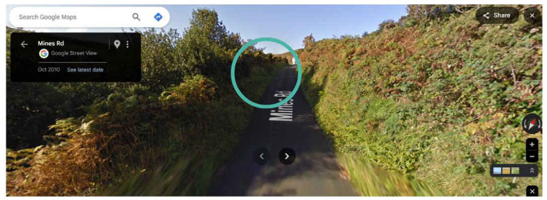
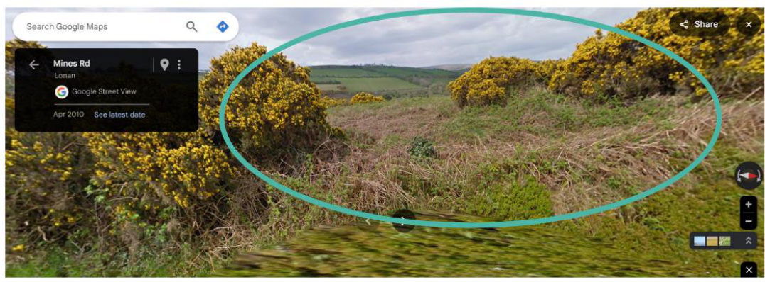
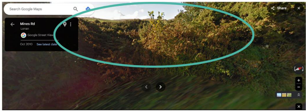
The site comprises three field entrances are the land they serve, situated along Mines Road, a singletrack rural lane connecting Laxey and Agneash. The surrounding area is characterised by open countryside with high scenic value, designated as being of High Landscape or Coastal Value and Scenic Significance under the Isle of Man Strategic Plan. Historically, the land was part of Ballacowle Farm, reflecting a strong agricultural character.
Historical Background Historical evidence supports the existence of these gateways:
‘It is discernible that where you have reinstated the historic entrance to field 614954 (field 524 on the old map) was historically a gateway because the Ordnance Survey cartographer took a Bench Marked spot height measurement at this location, which is marked on the map with the Bench Mark symbol and the annotation ‘B.M. 397.7’, which means ‘Bench Mark – height 397.7 feet above sea level’. At such locations, the cartography was required to chisel in the symbol of a Bench Mark (see below) onto a prominent feature in the landscape so that future cartographers were easily able to locate it. A stone gate post was therefore the most often used feature in the Manx countryside for this purpose.’
With regards to Access 2, Mr Bellamy comments as follows:
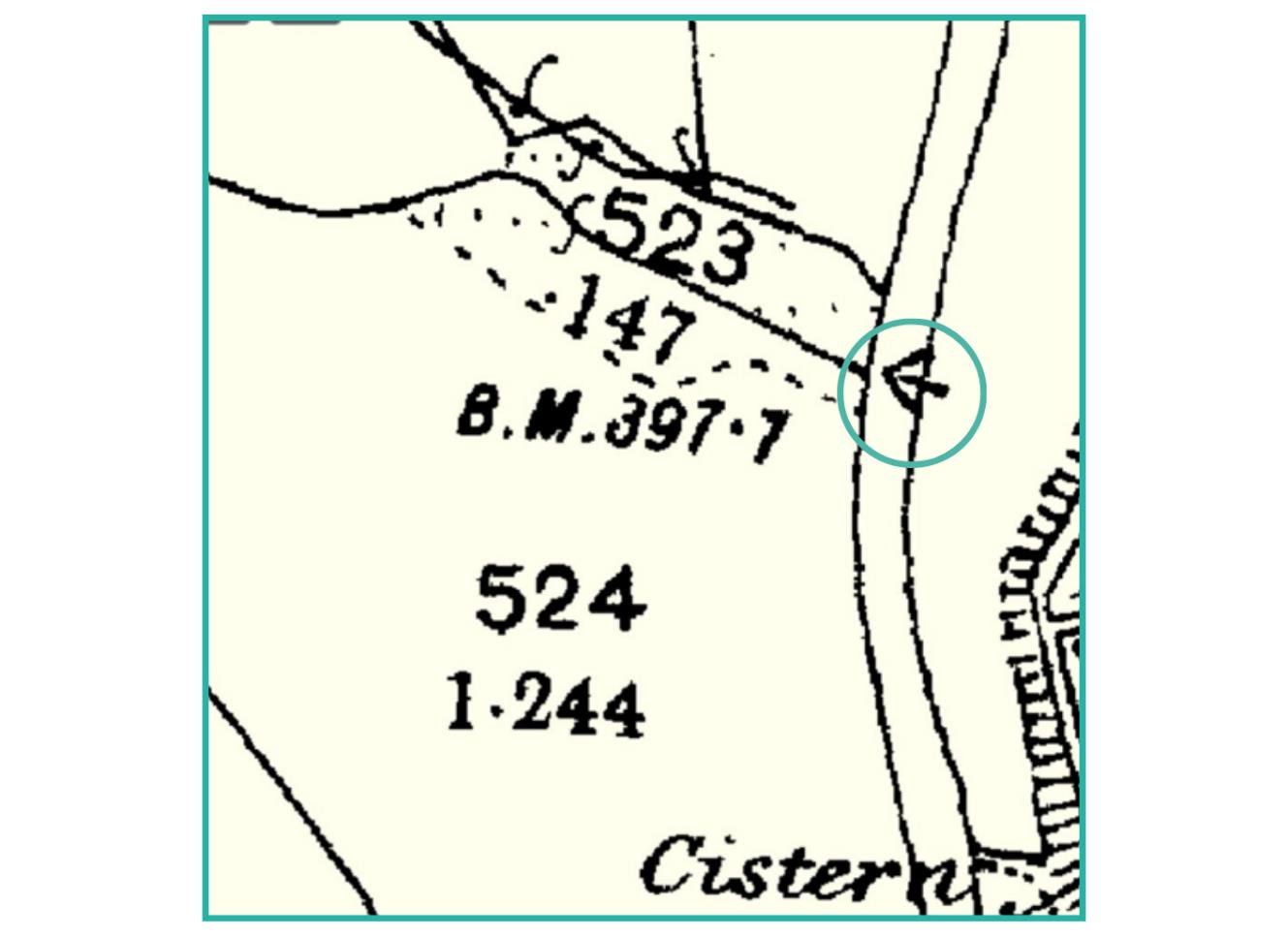
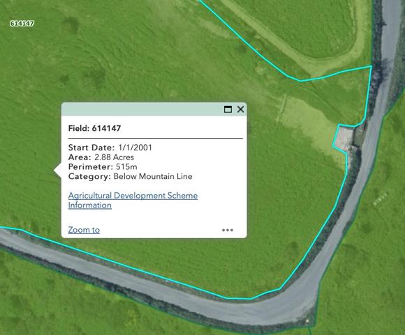
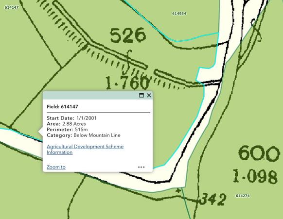
‘In terms of the other gateway further down the hill into field 614147, the Isle of Man Government’s MANNGIS mapping of this field was last undertaken in 2001 (see the DEFA Island Environment map) which clearly shows the gateway was in its present location, as was a small hardstanding. We know this because this area was deliberately excluded from the area of the field which was mapped as being eligible for agricultural subsidies (green area outlined in blue below).’
He goes on to state:
‘Significantly, this exact location is also the original crossing point of the overground lade which originally fed water to the Great Laxey Wheel (see historic map below):’
‘On Tuesday 31st May 2016, I responded to my alerter and attended a substantial gorse fire located in a field in the area of Ballacowle House, Agneash.
Upon arrival at the scene as driver of the 6 wheel drive Fire Servide Pinzgauer, I was instructed to gain access through the existing gateway into the field. This meant a rotted, wooden gate and a large amount of gorse needed to be removed using our reciprocating saw. This was all subsequent to the instruction of Sub Officer, Mark Taylor.
Gaining access to this field allowed the Fire Service to extinguish the heathland fire as timely and efficiently as possible.’
The Manx Radio article posted on their website Tuesday, 31 May 2016 17:36, covering the incident can be accessed at https://gold.manxradio.com/news/isle-of-man-news/heathlandfire-at-agneash/
The article is included below for ease of reference: Twenty crew tackle blaze Around 20 firefighters are tackling a blaze on heathland at Agneash outside Laxey. The alarm was raised at 3.20 this afternoon, and three appliances from Douglas were dispatched to assist the two crews in Laxey. Officers at the scene say winds have fanned the flames and water supply has been a problem but are confident the fire is under control. There was concern in the early stages that property might be at risk, but there are no reports of damage to any buildings. Access to the heathland is via a single track road, and officers say the topography of the area has made what would normally be a straightforward fire-fighting operation, more difficult. Local people reported seeing smoke rise from behind the Laxey Wheel, but there's been no disruption to traffic.
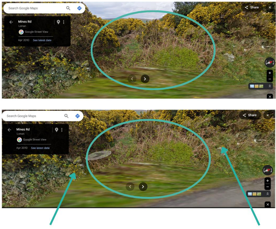
The works involve reinstating and widening the gateways to meet modern agricultural requirements. Each gateway has been designed to:
To prevent unauthorised use, such as for parking, accesses 2 and 3 are proposed to be gated and fenced so that there is only a consolidated tarmac surface extending 6 metres from the highway edge. This is proposed to comply with the Manual for Manx Roads (Manx Roads) requirements.
This policy requires developments to provide safe and efficient access to the highway network. It states:
“The new and existing highways which serve any new development must be designed so as to be capable of accommodating the vehicle and pedestrian journeys generated by that development in a safe and appropriate manner, and in accordance with the environmental objectives of this plan.”
The proposal satisfies this policy by:
The proposed gateways comply with Transport Policy 4 as they do not create a new development that generates additional vehicle or pedestrian movements but instead reinstate historic accesses for continued agricultural use. The design improvements, including enhanced visibility, widened entrances and the provision of bound surfacing, ensure that agricultural vehicles can safely enter and exit the fields without obstructing the carriageway. Additionally, drainage channels have been incorporated to prevent surface water runoff, mitigating any potential impact on road safety. By physically restricting access to agricultural use and preventing unauthorised parking, the proposal maintains the environmental objectives of the plan, ensuring that the rural character of the area is preserved while providing safe and appropriate access. The gateways also contribute to pedestrian safety by supporting informal passing places along this narrow rural road, further enhancing the overall functionality of the highway network in a manner consistent with the policy.
Environment Policy 1: Protection of the Countryside This policy seeks to protect the Isle of Man’s countryside from unwarranted development. It states: “The countryside and its ecology will be protected for its own sake. For the purposes of this policy, the countryside comprises all land which is outside the settlements defined in Appendix 3 at A.3.6 or which is not designated for future development on an Area Plan. Development which would adversely affect the countryside will not be permitted unless there is an over-riding national need in land use planning terms which outweighs the requirement to protect these areas and for which there is no reasonable and acceptable alternative.” The reinstatement of these historic gateways aligns with this policy by:
The proposed gateways align with Environment Policy 1 as they do not introduce new development that would adversely affect the countryside but instead reinstate historical field accesses that have long existed in the agricultural landscape. The works are designed to support continued agricultural use, which is an integral part of the rural environment, and maintain the character of the area through the use of traditional materials and sensitive landscaping. Furthermore, the proposal enhances safety and functionality without altering the ecological balance or landscape quality. The limited scale of the
works, coupled with their role in facilitating responsible land management and emergency access, ensures that they do not conflict with the overarching aim of protecting the countryside for its own sake. Importantly, there is no reasonable or acceptable alternative that would achieve the same level of agricultural and public benefit while maintaining the integrity of the landscape.
The Town and Country Planning Act 1999 states "agriculture" includes horticulture, fruit growing, seed growing, dairy farming, the breeding and keeping of livestock (including any creature kept for the production of food, wool, skins or fur, or for the purpose of its use in the farming of land), the use of land as grazing land, meadow land, market gardens and nursery grounds, and the use of land for woodlands where that use is ancillary to the farming of land for other agricultural purposes, and "agricultural" shall be construed accordingly." The tenant farmer’s letter confirms that the gateways are essential for these purposes. Without them, the fields would become impractical to farm, risking abandonment and a loss of agricultural productivity.”
The geology underlying the site is classed as Loamy Sand/Sandy Loam and the site is within Section "D2 - Laxey" of the Character Assessment. The Landscape Strategy is described as: "The overall strategy is to conserve and enhance the character, quality and distinctiveness of this area, with its relatively sparse settlement other than the characteristic settlement of Laxey, its distinct small scale field pattern, its valley bottom woodland along National Glens and the setting of the various historic and archaeological features within the area."
The proposal aligns with the Landscape Strategy for Section D2 - Laxey by conserving and enhancing the existing rural character and field pattern of the area. The reinstated gateways respect the smallscale field structure by maintaining traditional agricultural access points, using materials such as sod banks, timber gateways, and post-and-wire fencing that are in keeping with the landscape’s distinct character. The proposal does not introduce any urbanising elements or alter the underlying geology of Loamy Sand/Sandy Loam, ensuring that the natural landform remains intact. Furthermore, the design integrates with the surrounding environment and avoids any adverse impact on woodland, historic features, or archaeological assets within the area. By improving access while retaining the visual and ecological integrity of the landscape, the scheme upholds the strategy’s aim of preserving the quality and distinctiveness of Laxey’s countryside.
The estimated use of the gateways is limited to three times per year for agricultural purposes. This infrequent use demonstrates that the reinstatement does not materially intensify traffic on Mines Road, Agneash, addressing concerns raised during the original application.
This revised application proposes positioning the gates for Accesses 2 and 3 six metres back from the edge of the highway. This adjustment minimises the potential for unauthorised parking while simultaneously enhancing the safety of access and egress to the fields. By implementing this design improvement, the proposal offers a significantly safer arrangement than simply reinstating the gateways in their original format. This key modification directly addresses one of the primary reasons for refusal outlined in the previous decision notice, ensuring compliance with planning and safety requirements.
The mouths of the gateways function as informal passing places, improving safety on this narrow, single-track road. This additional benefit enhances the usability of the road for all users.
The reinstatement of the gateways has been carried out with sensitivity to the area’s scenic value. Specific measures include:
It is notable that in assessing the previous application, the case officer made the following conclusions:
“In respect of the visual impact of the works as carried out, these commenced approximately 3 years ago, and the rawness of the works has dissipated over the intervening time period. The grass, gorse and other foliage around the access points, and in relation to the northernmost access serving No. Field No. 614954, the use of Manx stone to re-instate the entrances sides has ensured that the accesses appear in keeping with the banks into which they have been installed in terms of natural reestablishment of flora, and vernacular use of local materials, and the ground cover has been reestablished. The visual impacts of the works to all three access points enabling access to these
existing field access is considered to be acceptable and accord with the provisions of Policies SP1 b), SP3 b), SP4 b) GEN2 b), c) d), e) and f); and, ENV1 of the Isle of Man Strategic Plan 2016.”
Agricultural Need
Gateways 2 and 3 are essential for effective field management, enabling safe access for modern agricultural machinery. Without these gateways, farming operations would be severely restricted, leading to underutilisation of productive land. This is confirmed by the current tenant farmer in their letter submitted as part of the application and in the excerpt included below:
‘If the old field entrances end up being shut, I’d have no choice but to stop grazing the fields – it simply wouldn’t work without proper access. It’d be too much hassle and not worth it. For context, I’d only need to access the fields about three times a year anyway.
You asked about shutting one of the entrances, but that’s not practical either. It’s risk mixing up different groups of livestock, which isn’t something I want to deal with.’
Access 1 is required by the owners of Ballacowle Cottage to enable them to maintain the bank to the front of their property. This would mean limited use at 2-3 times per year. Access 1 also provides an alternative access for agricultural vehicles in the event that other access points are for any reason unavailable. It is notable that in the consideration of the previous planning application, Highways Division made the following comments:
‘The extent of works at this access is minimal, constituting of reopening of the access only. Visibility supplied by the applicant has shown approx. 30m to the left on exit and 5m to the right on exit, from a 2m setback. To the left on exit, visibility is sufficient and allows full view of all movement around the bend. To the right, 5m is not sufficient for any 85th speed provided in Manual for Manx Roads. In order to see down the road a vehicle would have to encroach onto the road. However, due to the alignment of the road at this point, there is substantial forward intervisibility, and any encroachment will be visible by oncoming vehicles. The minimal amount of work to this access, and if considered existing, Highways would have no objection to the work done to this access.’
The case officer assessing the planning application made the following conclusions:
‘I find access 1 acceptable - evidentially, it is most likely pre-existing with the long track leading up to it at an angle along the hillside.’
It is considered that Gateway 1 has been deemed to have minimal impact in terms of highway safety or visual amenity and has previously been considered to have been pre-existing. It is required to enable effective land management and maintenance and provide alternative access in rare instances of agricultural need. Emergency Access The gateways provide critical access points for emergency services. During the 2016 heathland fire, the lack of easily accessible entrances hindered firefighting efforts. However the fire service was able to use access 2 to gain entry to the land subject of the fire by undertaking some light vegetation clearance work. The reinstated gateways ensure that emergency vehicles can quickly access the
fields in future emergencies should they occur. This would help fire crews contain any future heathland fire more effectively, thereby serving to protect the nearby Laxey Wheel.
The widened entrances provide informal passing places, reducing the need for reversing on this narrow road. This improvement benefits all road users, including cyclists and pedestrians, by enhancing overall safety.
Road Safety Concerns
Enhanced visibility and the restriction of unauthorised use through fencing and gating mitigate the perceived risks associated with these gateways when assessed previously. These measures ensure safe and appropriate use, addressing concerns raised by two local residents.
Ecological Impact The works have been carried out with minimal disruption to existing hedgerows, preserving the ecological integrity of the area. Intensification of Use
The estimated use by the tenant farmer of three times per year confirms that the gateways will not lead to significant increases in traffic or activity. Furthermore, agricultural vehicles tend to have higher seating positions, aiding the ability to see. Users of the accesses will be familiar with the road and access layout, further minimising any potential for incidents to occur. The proposed use aligns with their historical function and does not constitute intensification.
Barbara and Stewart Clague, in memory of their daughter, established The Ballannette Trust Charity to support environmental and community initiatives. One of their most significant contributions has been the transformation of the former Laxey municipal rubbish tip into the now fully restored Snaefell and Agneash Nature Reserve. This extensive restoration project was completed at no cost to the Government, relying instead on the dedication of family members and volunteers.
The land to which this application relates continues to be used for agricultural purposes. In addition to its farming function, the applicants have taken proactive steps to enhance public enjoyment by providing a footpath that is open to the public. While the creation of this footpath did not require planning approval, the existing accesses offer an important function for those using the paths. These entrances facilitate safe and convenient access to the countryside, ensuring that the footpaths remain a valued community asset.
Should the accesses be required to close, it would represent a loss not only for the applicants but for the wider community, including those in Agneash who use and enjoy them, Island residents and visitors to the Isle of Man. The footpaths provide an important recreational opportunity, connecting people with nature and promoting outdoor activity. Retaining these accesses ensures that the benefits of the Nature Reserve and agricultural land management continue to be fully realised, contributing to both environmental stewardship and public wellbeing.
This resubmission robustly demonstrates that the reinstatement of the field entrances at Agneash is justified on historical, practical, and policy grounds. The proposals provide clear evidence that the accesses are pre-existing, falling within the scope of Permitted Development or de minimis actions. This foundational argument is further strengthened by the client’s proactive decision to enhance the safety and functionality of the accesses, rather than simply reopening them.
Key improvements include increasing visibility and implementing consolidated surfacing to prevent debris from entering the public highway. These measures directly address the concerns raised in the original refusal, ensuring compliance with highway safety standards and reducing risks for all road
users. Additionally, the reinstated gateways have been carefully designed to maintain and enhance the rural character of the area, utilising traditional materials and sensitive landscaping to achieve a harmonious integration with the surrounding environment.
The gateways are essential for enabling sustainable agricultural operations, ensuring the effective and productive use of the fields. Furthermore, they provide critical emergency access benefits, as demonstrated by the successful use of Access 2 during the 2016 gorse fire. Their design also delivers broader public and community benefits by creating informal passing places on the narrow road, improving traffic flow and safety. The addition of publicly accessible footpaths, which do not require planning approval, further enhances the community’s access to the countryside.
Approval of this application will secure the sustainable management of these fields while preserving their historical and scenic value. This balanced approach reflects both historical precedent and modern planning requirements, achieving a solution that supports agricultural productivity, enhances public safety, and maintains the unique character of the Isle of Man’s rural landscape.
Copyright in submitted documents remains with their authors. Request removal