PLANNING STATEMENT IN SUPPORT OF ALTERATIONS TO THE EXISTING DWELLING, THE ADDITIONAL USE OF PART OF THE DWELLING AS OFFICE AND MEETING SPACE IN ASSOCIATION WITH THE BOTANIC GARDEN PROJECT, THE DEMOLITION OF THE EXISTING GARAGE AND ITS REPLACEMENT WITH A GLASS HOUSE AND REMOVAL OF ONE VEHICULAR ENTRANCE ONTO THE LANE, BALLAVALE BARNS, BALLAVALE ROAD, SANTON IM4 1EH
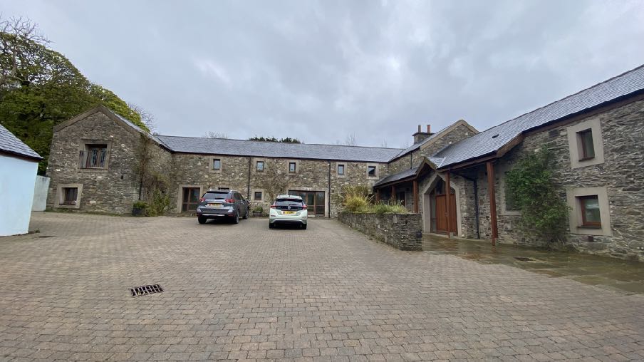
A photograph showing a large stone building complex with a paved driveway and two parked cars, set in a rural environment.
1.0 Introduction
1.1 Ballavale Barns is a single residential property situated off a lane which runs to the east of Ballavale Road (B26). The dwelling sits to the south of the lane and comprises a group of partly former agricultural barns and some new build structures, arranged around a square courtyard.
1.2 Access is available into the site from the lane in two places - to the west of the complex and in between the existing garage and the eastern side of the dwelling.
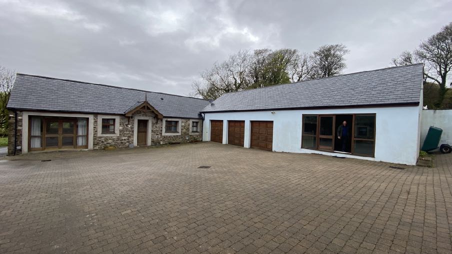
1.3 The complex is mostly renovated stone barns with the only completely new building on previously undeveloped space being the garage which backs onto the lane. This is a rendered structure with three garage doors and a large pedestrian door giving access to a gym area to the east of the garaging.
1.4 Beside the garage is another stone building which was a replacement of a former stone building and originally accommodated a garage and boat store and most recently had planning approval for conversion to a one bedroomed tourist unit.
A photograph showing the exterior of a single-story property featuring a stone section and a white section with three garage doors and a large paved driveway.
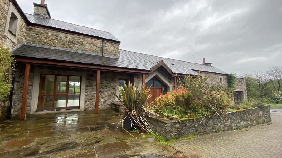
1.5 The main living accommodation is arranged in the L shape formed by the southern and eastern sides of the courtyard. This accommodates a music room utility, kitchen, family room, dining room, hall, study and lounge on the ground floor with five bedrooms above.
1.6 The main entrance into the property was under a peaked roofed verandah styled canopy on the northern elevation of the southern side of the building group.
1.7 The centre of the courtyard is paved with the ground rising up from west to east. The parking area and access are smaller paving bricks with the pedestrian area immediately around the buildings being larger stone slabs.
1.8 The dwelling sits in an area bounded by the lane to the north, the railway line to the south, a hedge and stream to the west and the curtilage of Ballavale Farm house to the north east. All of the surrounding area is in the same ownership as the application site as shown on the location plan.
1.9 The property has recently been sold by the person who sought and gained permission for and implemented the schemes for conversion and new build on the site. The property is
A photograph showing the exterior of a stone-built detached dwelling with a modern glass extension or patio area on the left side. The property features a paved patio, a low stone wall with landscaping, and a driveway in a rural setting.
now owned in conjunction with the site of the approved scheme for the creation of a botanic garden (see 2.9 Planning History below).
2.0 Planning history
Ballavale Barns
2.1 The site was the subject of a number of applications for the conversion of the building to a dwelling (01/01130/A, 02/01228/B, 04/00624/B and 05/01006/B).
2.2 In 2006 applications were submitted for the “necessary demolition of further limited areas of the existing structure” and modifications to regularise additional demolition over and above what had been permitted in the conversion in the previous application. These applications, 06/00205/B and 06/02243/B were permitted.
2.3 An application to erect an annex for additional living accommodation was refused under 08/02324/B.
2.4 10/00041/B proposed the erection of the replacement building to provide the gym, boat store and garage and was permitted.
2.5 13/91380/B - conversion of the existing gym, garage and boat store to tourist accommodation - permitted.
Ballavale Farmhouse
2.6 Ballavale Farmhouse alongside to the north east was originally approved as an agricultural dwelling but after a period of non compliance with the occupancy condition, a Certificate of Lawfulness was issued (06/00299/LAW) in respect of the use of the property as a private dwelling as it has been used ever since.
2.7 The site was then the subject of applications for extensions which were refused (06/01878/B), a wooden outbuilding, 13/00328/B which was permitted, extension of the approved outbuilding under 15/00115/B which was also approved. This property is now within the ownership of the applicant.
Ballavale Farm Old Farmhouse
2.8 Ballavale Farm Old Farmhouse across the lane from the application site was permitted for replacement under 02/00686/A and 04/00531/B and for a conservatory under 04/02233/ B. This property is now within the ownership of the applicant.
Land alongside Ballavale Road
2.9 The applicant’s ownership extends significantly in all directions from the application site as shown on the submitted plans and importantly includes land which was the subject of four applications which cumulatively proposed to create a botanic garden. These applications were:
13/00830/B - creation of a production house and walled garden (amended under 16/00358/ B
13/00831/B - creation of a water cascade and amphitheatre
13/00832/B - creation of meadow orchard, meadow, lake, wetlands, boglands and glen 13/00834/B - creation of gardener’s compound and sensory garden: this incorporated new buildings for vehicle and machinery storage as well as a more formal building for education, changing facilities, office facilities, archive library and kitchen facilities. These new buildings have not been implemented 13/00365/B - erection of temporary greenhouse
Ashdowne House
2.10 This property sits alongside the access to the Santon Railway Station, on the western side of Ballavale Road and has permission for the creation of a new house through the redevelopment of the former dwelling, under 12/00355/B, 15/00902/B, 16/00160/B, 18/00040/B and 23/00244/B. This property is within the ownership of and is the residence of the applicant.
Ballachrink Farm
2.11 This farm sits alongside the A25 Old Castletown Road and comprises two dwellings and a range of new and older agricultural buildings. This farm is now in the ownership of the applicant and recently planning approval was granted for the alterations and extension to the old farmhouse to provide facilities for those working within the estate and also living space for visiting consultants (21/00299/B). These visiting consultants are associated with the botanic garden project.
2.12 The planning officer notes in his report:
2.6 ...The land which was formerly agricultural is now being developed as abotanic garden which requires more intensive hands-on management, both fromlocal resident staff and from visiting experts. Whilst previously there would have
been daily care and physical management of the land and its stock, the management now involves botanical planting, and maintenance of trees, waterways and meadows. The land in question used to employ one permanent farm worker, but now employs nine permanent horticultural and botanical staff, with a commensurate increase in need for welfare facilities. The botanic garden also requires the intervention and involvement of visiting specialists - botanists and landscapers from different regions - whose permanent presence on the land is not required. It is still proposed for the farmhouse to be residential for those associated with the running of the botanical garden.
3.0 Planning policy context
Area Plan for the East
3.1 The site lies within an area designated on the Area Plan for the East as not for a particular purpose - essentially countryside as defined in Environment Policy 1 of the Strategic Plan.
3.2 On the Environmental Constraints Map which accompanies the Area Plan, the land to the immediate west of the buildings and to the north is identified as being of ecological interest (draft) and the land to the north is identified as accommodating Registered Trees.
3.3 The Registered Tree area is shown more clearly on the Island Environment Map shown below where there are no sites of ecological significance highlighted.
This image displays a zoomed-in section of a site plan or location map featuring distinct areas marked with green and yellow cross-hatching over black line drawings of boundaries and structures.
3.4 There are no constraints shown on the Infrastructural Constraints Map and the site lies outside of the area where there are building height restrictions due to the proximity to the Isle of Man Airport.
3.5 There are no Community Constraints shown on the relevant map accompanying the Area Plan.
3.6 In 2008 the Department commissioned a Landscape Character Assessment of the Island, intending to replace the areas of High Landscape or Coastal Value and Scenic Significance on the Isle of Man Planning Scheme (Development Plan) Order 1982. The site falls into an area so designated in 1982. Rather than qualitative designations, the Landscape Character Assessment divides the Island into character types. The application site falls within the D13 Incised Inland Slopes area and the full assessment (which is provided at Appendix One) is set out in the Area Plan as follows:
Landscape Character Area Santon (D13) Landscape Strategy Conserve and enhance:
a) the character, quality and distinctiveness of the area, with its wooded valley bottoms and wooded horizons;
b) its scattered settlement pattern;
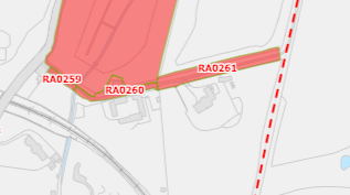
A site plan showing red highlighted areas labeled RA0259, RA0260, and RA0261, indicating specific land parcels or zones for the proposed development.
c) its Victorian garden and the railway.
Key Views Open and expansive views from the higher areas along the rugged coast in the east and inland towards the upland areas over Braaid. Incinerator chimney forms a notable landmark in the immediate area. Glimpsed views framed by vegetation in the valley bottoms and along the main roads where they follow the wooded valley bottoms. Views in the northern part of the area up to the Transmitting Masts on top of Douglas Head hill top. Views from Isle of Man Steam Railway
3.7 This is followed by a proposal:
Landscape Proposal 7 (Santon) In cases where new development is proposed, applications must demonstrate that it can be suitably integrated into the surrounding landscape setting through reasonable mitigation measures and considering siting, colours, materials, finishes and the general scale.
3.8 The Area Plan also contains policies protecting the steam railway and views therefrom:
Landscape Proposal 10 (for the Manx Electric Railway, the Mountain Railway and the Isle of Man Steam Railway).
This is applicable to those linear corridors for the named railway forms, the linesof-sight required for their safe and continued operation and also as a consideration to sites proximate to those corridors and where the predominant view is of those corridors.
For the Isle of Man Steam Railway - Views as seen from Isle of Man Steam Railway are to be preserved; development which would significantly intrude on such views will generally not be supported. Safety and continued operability will require some clear line-of-sight corridors, and these shall be maintained.
For the Manx Electric Railway (including the Mountain Railway) - Views as seen from the Manx Electric Railway are to be preserved; development which would significantly intrude on such views will generally not be supported. Safety and continued operability will require some clear line-of-sight corridors, and these shall be maintained.
Prospective Applicants wishing to develop along these routes (which includes sites located adjacent to the boundary of the railway line or within close proximity to the transport corridors) should engage with the Department of Infrastructure 33 for advice ahead of the submission of any planning application. Prior to any decision on a planning application for which Landscape Proposal 10 is relevant, advice will normally be sought from the Department of Infrastructure.
3.9 Environment Policy 2 confirms that the areas of an area of High Landscape or Coastal Value and Scenic Significance will be replaced by a landscape classification which will introduce different categories of landscape and policies and guidance for control therein. The Landscape Character Assessment introduces such a classification although cannot introduce policies which are the sole domain of the Strategic Plan or Planning Policy Statement (PPS): Area Plans may only introduce proposals, not policies. Whilst there is a draft PPS in the role of Landscape Character in Development which encompasses the landscape classification types in the original 2008 Assessment and the East and South Area Plans, it is not yet adopted. There are therefore no policies related to the Landscape Character Assessment so it is relevant to still make reference to Environment Policy 2 of the Strategic Plan where development is proposed in areas of an area of High Landscape or Coastal Value and Scenic Significance: this states that within these areas the protection of the character of the landscape will be the most important consideration unless it can be shown that: (a) the development would not harm the character and quality of the landscape; or (b) the location for the development is essential.
Isle of Man Strategic Plan 2016
3.10 The Strategic Plan provides planning guidance which applies to all of the Island. Here, development is generally directed towards settlements (Strategic Policies 1, 2 and 10, Spatial Policy 5 and Transport Policy 1). The countryside is protected for its own sake (Environment Policy 1) and development which is harmful to the countryside is presumed against.
3.11 Office development, like most development is directed towards settlements (Strategic Policy 9 and Business Policy 7.
3.12 Car parking is required to be provided in accordance with the standards in the Plan (Transport Policy 7) which are given at Appendix Seven of the Strategic Plan. The standard for out of town offices is 1 space per 15 sq m of office space (nett).
3.13 Development is expected to have an acceptable impact on highway safety and the local road network (Transport Policy 4).
3.14 Development is expected to comply with the general standards set out in General Policy 2.
4.0 The proposal
4.1 Proposed is the additional use of the existing buildings to accommodate office, conference and meeting space related to the adjacent botanic garden project, as was the accommodation permitted in 21/00299/B, and for a range of physical alterations all in association with the development and use of the wider botanic garden scheme. Also proposed is the replacement of the existing garage block with a glass house, also associated with the botanic garden.
4.2 The physical changes comprise the following:
• The demolition of the existing garage and gym and their replacement with a glass house
• The introduction of a new principal two storey glazed entrance feature with an open sided, single storey timber porch
• The change of some existing doors to windows
• Closing off of the vehicular access in between the existing house and existing garage
4.3 Internal changes will involve the renaming of certain rooms - the laundry to a kitchen, the kitchen and family room to office space and the dining room to a video conference facility. The upper floor will remain as sleeping accommodation. The building will remain capable of being occupied as a dwelling alongside the use of the office facilities and if and when they are not used for such purposes. There are no structural changes to facilitate these uses and the office and video conference spaces are capable of being used as living space should this be required.
4.4 The proposed use is in connection with the developing botanic gardens to the south, which are also in the applicant’s ownership. The applications referred to at 2.9 above have all been commenced although the proposed new machinery and vehicle store and the library/office/education building have not been started.
4.5 Since those approvals and the commencement of the botanic garden project, the applicant has acquired considerably more land in the vicinity of the site, including Ballachrink Farm to the south, Ballavale Barns, Ballavale Farmhouse and Ballavale Farm Old Farmhouse to the east. As a result of these acquisitions, the applicant has a range of buildings available to him which he did not have at the time of the 2013 approvals and the proposed botanic garden scheme may make use of these rather than building completely new buildings. This is reflected in the approval granted under 21/00299/B at Ballachrink Farm.
4.6 In addition, as a result of these acquisitions, the botanic garden project has evolved and as the works progress, the involvement of more consultants and botanical specialists has grown. With this, there is a growing need for space to accommodate these visiting professionals, not only overnight accommodation but also space for meetings, discussions and where they may work. Ballavale Barns provides an excellent opportunity to provide this accommodation, at least temporarily should a longer term solution not be found. The property has adequate space to provide the flexibility of accommodating these new uses as well as remaining a place of residence when the proposed uses are not needed.
4.7 Ballavale Barns is a very short distance from the nearest parts of the botanic garden site
easily and safely walkable and would provide ideal additional accommodation required in connection with the project without the erection of any new buildings.
4.8 The site also provides the opportunity for a new glasshouse. The approved glasshouse in the area to the south west is unlikely to be constructed and the applicant wishes to remove the existing garage and gym which are accommodated in a building of poor form which does not complement the existing stone building courtyard and replace it with a new glass structure which will support the overall botanic garden project as well as improving the appearance of the building group.
4.9 Those visiting the proposed office and meeting space will be those consultants and advisers who visit the site who will be collected at their point of arrival and brought to the site, not increasing the amount of vehicles generated or needing to park on the site. In any case there is a large courtyard which can accommodate at least 6 vehicles which is more than sufficient for the proposed use of the site. It is also relevant that whilst there are three garages spaces being lost as a result of the proposed changes to the building, these garaged spaces required space in front of the garage for access and as such, there will be no nett loss of car parking space as a result of the proposal.
4.10 The proposed physical changes to the building are partly proposed to accommodate the additional use of the building but are also suggested as visual improvements to the dwelling. At present there is no obvious principal entrance into the building - the significance of the existing entrance on the northern side of the southern elevation is diluted somewhat by the verandah style canopy. The proposed porch on the eastern side of the square is modest but draws attention to that elevation and directs anyone coming into the courtyard
to the main entrance into the building. The additional glazing will add to this and will introduce interest to this elevation.
4.11 The changes from doors to windows will reflect the random appearance of the former agricultural building and better reflect its character.
5.0 Conclusion
5.1 The proposed additional use of this building as office and meeting space for the adjacent botanic garden project will be a welcome asset to the project. The planning policies support the retention and reuse of redundant buildings in the countryside, which led to the original conversion of these buildings to the dwelling which now exists. Those policies do not restrict such conversions to purely residential use and Environment Policy 16 also allows for a range of non residential uses of such buildings, including offices.
5.2 A recent appeal decision for a former barn elsewhere in the south of the Island demonstrates that simply because a building has previously been converted to a different use, it is not unacceptable for further, different uses to be considered acceptable if they satisfy the other requirements of that policy. 24/00287/C confirms that it is acceptable to convert buildings in the countryside to office use and even in the case of a building which had originally been converted to a different use from an agricultural function.
5.3 In this case, the proposed additional use is directly associated with the adjacent botanic garden project and will accommodate persons involved with it. Those visiting will be engaged on the project and no other work and as such, their accommodation within the project area will result in a more efficient and sustainable than if they were accommodated within any of the nearest settlements and would have to travel to and from the site throughout their visit complementing the accommodation available at Ballachrink Farmhouse (21/00299/B). The applicant would be happy to accept a condition which restricts the occupation and use of this building to only those engaged in the project although this was not controlled in the 21/00299/B.
5.4 The physical changes to the building help its function in guiding users to the main entrance and create a modest traditionally styled porch. The glazed section above it is a more modern feature but not, we would suggest, alien or inappropriate in this courtyard which will also be complimented by the proposed large glazed glasshouse.
5.5 The botanic garden is a unique project which will benefit the Island ecologically and provide valuable botanical international connections and promote our understanding of different climates, optimal growing conditions and better understanding the local environment. There has already been considerable work undertaken in terms of planting, the creation of habitat and understanding what is growing well and also what is not;
significant wildflower habitat has been created and already the scheme is the subject of professional interest and involvement from non local ecologists and botanists.
5.6 A project of this size and complexity was always going to be subject to evolution and the acquisition of further land and particularly facilities has enabled the applicant to modify the proposal to utilise existing buildings rather than build completely new structures which is less intrusive to the landscape and more sustainable, reducing the need for new build and the environmental cost of that.
5.7 We would suggest that this current proposal will represent a more sustainable approach to the development of the botanic garden project with no adverse environmental impacts completely respecting the important landscape features and character of the area as set out in the Landscape Character Assessment and respecting and complying with Environment Policies 1, 2 and 16 and the objectives of Landscape Proposal 7.
5.8 The applicant would be happy to accept conditions which control the use of the office and conference space to those people associated with the botanic garden although would reiterate that this was not undertaken on 21/00299/B and also that the majority of the building remains as residential with the proposed office and meeting facilities not segregated or separate from the living space so a self contained, general office use would not be forthcoming should this current application be permitted.
Sarah Corlett 16.12.24
APPENDIX ONE EXCERPT FROM THE LANDSCAPE CHARACTER ASSESSMENT, 2008
D13 - SANTON Key Characteristics
• A predominantly rural landscape, dissected by A5 and A25 roads.
• Densely wooded valley bottoms amongst undulating rolling land with large rectilinear arable and pastoral fields on the gently sloping hill sides and rounded tops.
• Steep sided densely wooded Victorian pleasure Glens of Glen Grenaugh and Port Soderick Glen lead down to the coast.
• Victorian electric railway line and stations runs through the area at the bottom of Crogga Glen.
• Fragmented woodland along field boundaries and along tracks that access the scattered farm houses centred around Quine’s Hill (along the A25) and small settlements of Santon and Ballaveare.
• Sea-facing hill slopes with large open fields running along the cliff tops with gorse, heather and bracken along the cliff top periphery.
• Incinerator chimney forms notable landmark in the immediate area.
• Presence of Manx Milestones.
• Abrupt linear southern built edge to Douglas, comprising residential and industrial development with minor localised extension of industrial character into character area south of Cooil Road.
• Pulrose Golf Course on edge of Douglas
Overall Character Description Numerous gentle to steeply sided river valleys cut down into the landform to form an undulating and rolling character with pronounced incised valleys. Glen Grenaugh and Port Soderick Glen are steepsided densely wooded valleys, the latter appropriated during the Victorian period as pleasure Glens with walkways and features such as bandstands and bridges. Linear fragmented woodland runs along the valley bottoms of these National Glens and along Crogga River. Hedgerow trees and woodland blocks surround the numerous farms in the area, which are predominantly located in the north of the area around Quine’s Hill.
Medium sized rectilinear arable and pastoral fields delineated predominantly by Manx hedges and some post and wire fences form a strong geometric field pattern on the gently sloping hill sides and rounded tops in the south of the area. Smaller rectilinear fields enclosed by
Manx hedgerows, containing large hedgerow trees, cover the more settled north-eastern area where farmsteads such as Hampton Court and Cronkbane are concentrated. This field pattern stops abruptly in the north of the area where it meets the A24 and the linear builtup edge of Douglas. The far north-eastern part of the area comprises the Pulrose Golf Course, which extends in towards the centre of Douglas. Patches of gorse and heather grow in areas on the more exposed hill tops and along the eastern edges of the fields of the coastal facing slopes, along which the cliff top coastal path runs and forms the area’s seaward boundary.
The busy A25 runs along the lower valley sides with small, often steep and winding tracks branching off perpendicular from the main road to provide farm access, while smaller predominantly straight B roads, enclosed by tall hedgerow vegetation, which follow the grain of the rectilinear field pattern and link the small and wooded settlements within the area such as Santon and Seafield. The Victorian Electric Railway runs through the area along Crogga Glen with stations at Santon and Port Soderick before skirting around the bottom of Douglas Head which forms the north eastern boundary. Moderate sense of tranquillity away from Douglas and the major roads.
Key Views
• Open and expansive views from the higher areas along the rugged coast in the east and inland towards the upland areas over Braaid.
• Incinerator chimney forms a notable landmark in the immediate area.
• Glimpsed views framed by vegetation in the valley bottoms and along the main roads where they follow the wooded valley bottoms.
• Views in the northern part of the area up to the Transmitting Masts on top of Douglas Head hill top.
• Views from Isle of Man Steam Railway
Historic Features
• Victorian Isle of Man Steam Railway and stations, including Port Soderick (Registered Building) and the Old Toll Booth (Registered Building).
Ecological Features
• Farmland grassland habitats.
• Mature network of hedgerows containing deciduous trees in field boundaries.
• Aquatic and waterside habitats along river courses.
• Dense riparian woodland in Valley bottom with deciduous woodland along valley sides.
• Exposed heathland on steeper sea facing slopes.
Key Issues and landscape sensitivities
• Wooded horizons and skyline seen from valley bottoms.
• Ecological value of the aquatic and waterside habitats.
• Various sized pastoral and arable fields with Manx hedges.
• Wooded valley bottom with fragmented woodland along substantial field boundaries.
• Scattered farmsteads fringed by trees.
• Wooded Victorian Pleasure Glen at Port Soderick.
• Victorian Isle of Man Steam Railway and stations.
• Presence of Manx Milestones.
Landscape Strategy The overall strategy should be to conserve and enhance the character, quality and distinctiveness of the area, with its wooded valley bottoms and wooded horizons, its scattered settlement pattern, its Victorian pleasure glen and the railway.
APPENDIX TWO
Strategic Plan policies
Strategic Policy 1: Development should make the best use of resources by: (a) optimising the use of previously developed land, redundant buildings, unused and under-used land and buildings, and reusing scarce indigenous building materials; (b) ensuring efficient use of sites, taking into account the needs for access, landscaping, open space(1) and amenity standards; and (c) being located so as to utilise existing and planned infrastructure, facilities and services.
Strategic Policy 2: New development will be located primarily within our existing towns and villages, or, where appropriate, in sustainable urban extensions(2) of these towns and villages. Development will be permitted in the countryside only in the exceptional circumstances identified in paragraph 6.3.
Strategic Policy 4: Proposals for development must: (a) Protect or enhance the fabric and setting of Ancient Monuments, Registered Buildings(1), Conservation Areas(2) , buildings and structures within National Heritage Areas and sites of archaeological interest; (b) protect or enhance the landscape quality and nature conservation value of urban as well as rural areas but especially in respect to development adjacent to Areas of Special Scientific Interest and other designations; and (c) not cause or lead to unacceptable environmental pollution or disturbance.
Strategic Policy 9: All new retail development (excepting neighbourhood shops and those instances identified in Business Policy 5) and all new office development (excepting corporate headquarters suitable for a business park(1) location) must be sited within the town and village centres on land zoned for these purposes in Area Plans, whilst taking into consideration Business Policies 7 and 8.
Strategic Policy 10: New development should be located and designed such as to promote a more integrated transport network with the aim to: (a) minimise journeys, especially by private car; (b) make best use of public transport; (c) not adversely affect highway safety for all users, and (d) encourage pedestrian movement
General Policy 2: Development which is in accordance with the land-use zoning and proposals in the appropriate Area Plan and with other policies of this Strategic Plan will normally be permitted, provided that the development:
(a) is in accordance with the design brief in the Area Plan where there is such a brief;
(b) respects the site and surroundings in terms of the siting, layout, scale, form, design and landscaping of buildings and the spaces around them;
(c) does not affect adversely the character of the surrounding landscape or townscape;
(d) does not adversely affect the protected wildlife or locally important habitats on the site or adjacent land, including water courses;
(e) does not affect adversely public views of the sea;
(f) incorporates where possible existing topography and landscape features, particularly trees and sod banks;
(g) does not affect adversely the amenity of local residents or the character of the locality;
(h) provides satisfactory amenity standards in itself, including where appropriate safe and convenient access for all highway users, together with adequate parking, servicing and manoeuvring space;
(i) does not have an unacceptable effect on road safety or traffic flows on the local highways; (j) can be provided with all necessary services;
(k) does not prejudice the use or development of adjoining land in accordance with the appropriate Area Plan;
(l) is not on contaminated land or subject to unreasonable risk of erosion or flooding;
(m) takes account of community and personal safety and security in the design of buildings and the spaces around them; and
(n) is designed having due regard to best practice in reducing energy consumption.
Environment Policy 16: The use of existing rural buildings for new purposes such as tourist, or small-scale industrial/commercial use may be permitted where:
a) it is demonstrated that the building is no longer required for its original purpose and where the building is substantially intact and structurally capable of renovation;
b) the reuse of the building will result in the preservation of fabric which is of historic, architectural, or social interest or is otherwise of visual attraction;
c) it is demonstrated that the building could accommodate the new use without requiring extension or adverse change to appearance or character;
d) there would not be unacceptable implications in terms of traffic generation;
e) conversion does not lead to dispersal of activity on such a scale as to prejudice the vitality and viability of existing town and village services; and
f) the use of existing buildings involves significant levels of redevelopment to accommodate the new use, the benefits secured by the proposal in terms of impact on the environment and the rural economy shall outweigh the continued impact of retaining the existing buildings on site.
Proposals to convert rural buildings to residential accommodation will be considered along with the advice given at Section 8.10 of this document.
Business Policy 7: New office floor space should be located within town and village centres on land which is zoned for the purpose on the appropriate area plan; exceptionally, permission may be given for new office space (a) on approved Business Parks for Corporate Headquarters which do not involve day to day callers; or (b) in buildings of acknowledged architectural or historic interest for which office use represents the only or most appropriate practicable and economic way of securing future use, renovation and maintenance.
Transport Policy 4: The new and existing highways which serve any new development must be designed so as to be capable of accommodating the vehicle and pedestrian journeys generated by that development in a safe and appropriate manner, and in accordance with the environmental objectives of this plan.
Transport Policy 7: The Department will require that in all new development, parking provision must be in accordance with the Department’s current standards.
Copyright in submitted documents remains with their authors. Request removal
Source & Provenance
Official reference
24/91397/B
Source authority
Isle of Man Government Planning & Building Control