Planning Statement In Support Of An Application For The Demolition And Reconstruction Of Existing Extension, Africa House, Woodbourne Road, Douglas Im2 3Ap
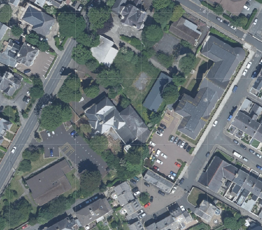
Aerial site location map showing the property and surrounding residential area with roads and parking lots.
1.0 Introduction
1.1 Africa House sits on the eastern side of Woodbourne Road. It is a detached house which sits lower than the road and within heavily landscaped grounds.
1.2 To the north of the site is the curtilage of Homefield - a site owned by Government and which accommodated until recently a former large dwelling which was used until its demolition, as the head offices of the Department for Home Affairs. The building has been demolished to make way for a new 73 bedroomed elderly persons’ car home and associated facilities (see Planning History). The Homefield site incorporates all of the site extending down to the rear of the Salisbury Street bus depot and to Murray’s Road but excluding the health clinic thereon.
1.3 To the south west is the Church of Jesus Christ of Latter Day Saints and associated car park.
1.4 To the south is a relatively new development of houses (Africa Court) and associated parking.
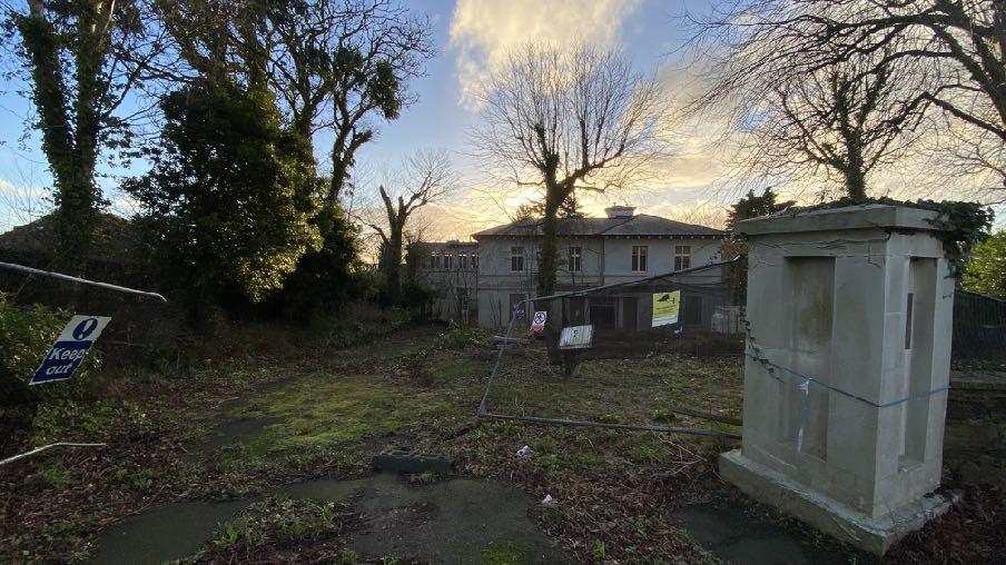
A photograph showing a grassy rear garden area with a fence, a concrete utility structure, and a large two-story house in the background surrounded by trees.
1.5 The property has been unoccupied for some time and has been subject to recent break ins, vandalism and arson attacks.
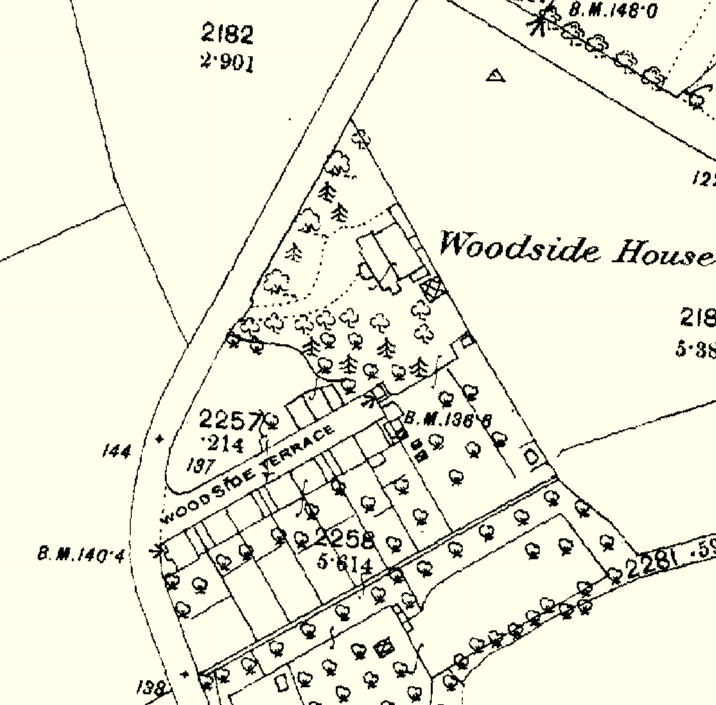
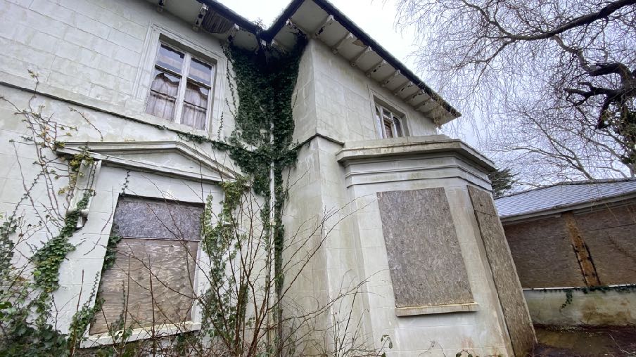
1.6 The building constitutes a core section which, as may be seen from the County Series maps dating back to 1860 shows the building sitting in relative isolation on what would have been then the outskirts of Douglas which was then about to become the capital of the Island, the capital at that time being Castletown. Africa House then was known as Woodside House and had nothing to the north, west and east and only the small group of houses known then and now as Woodside Terrace, to the south.
A black and white site plan or OS map extract showing property boundaries, trees, and building footprints for Woodside House.
1.7 The 1860s map shows clearly not only was Africa House a stand alone building in its own grounds, but also that those grounds were more significant than they are today and also that the entrance and approach to the property was from the south west on land which is no longer part of the curtilage of the property. This access now provides the entrance and exit to and from the Church of Latter Day Saints, a facility built much later than Africa House.
1.8 The former Homefield building is also a later addition to the street scene than Africa House although more traditional in style and appearance than the church, noted in the Conservation Area Appraisal as “2.5 storey Italianate villa from the Victorian period. This building is similar in form and style to many of those found along this section of Woodbourne Road, and occupies a key corner site with large acreage relative to the location.” Interestingly, no comments were made in respect of the significance of the loss of that building by any Conservation Officer or organisation in the relevant applications for its demolition.
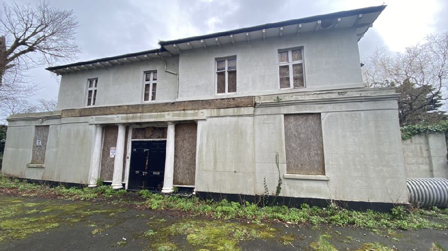
1.9 The buildings on the other side of Woodbourne Road came later still and now the site sits within a built up area with development on all sides. It now has an access which enters and leaves the site from effectively the side of the main historic core. This facade now has features which seek to create an obvious entrance to the building:
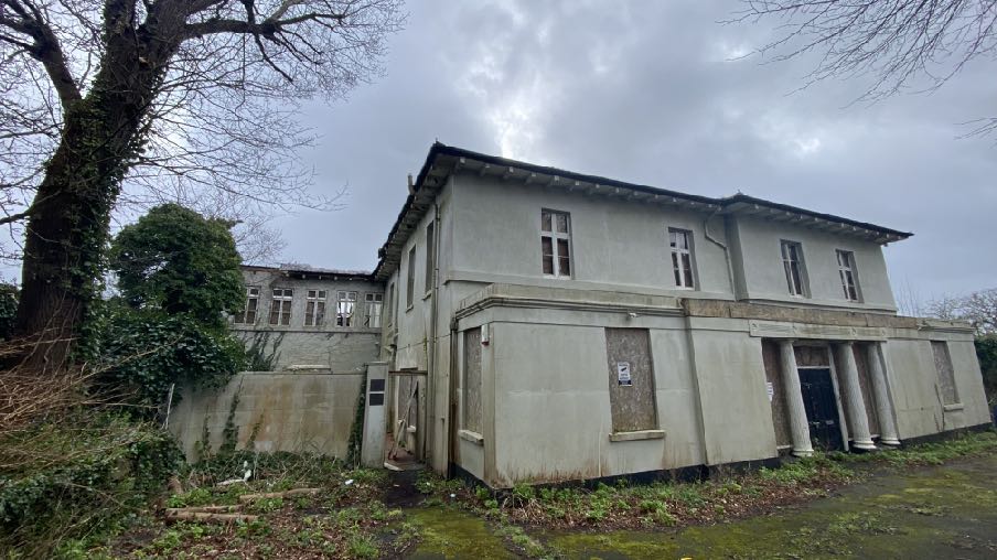
A photograph showing the front elevation of a two-story detached building with a lower single-story section featuring columns. The ground floor windows are boarded up, indicating disuse or ongoing renovation work.
but which lack the ornamentation and projections of the original entrance seen below as it appears today:
1.10 The original frontage (above) was symmetrical, which it still is at first floor level but with a single storey conservatory added to the right of the central entrance which unbalances the former principal frontage somewhat.
1.11 The original house has been altered and extended over time: it is clear from the photo above that a conservatory has been created alongside the original entrance which does not appear on the 1860s mapping and also that the original rear annex has been added to and altered with a significant single storey additional added to provide a swimming pool, thought to date from the 1970s and also a further rear annex accommodating dining and leisure facilities with bedrooms above added in the early 1980s.
1.12 As stated above, the property has been unoccupied for some time and has been subject to trespass and vandalism as well as a significant fire in August 2023 for which an individual was charged in 2024 with arson.
A low-angle exterior photograph of a white stone building featuring boarded-up windows and climbing ivy.
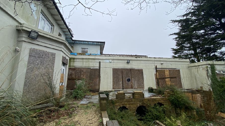
Swimming pool extension thought to have been added in the 1970s with part of the two storey annex added in the early 1980s appearing above it to the rear
1.13 The owner would now like and is in a position to address the current condition of the building and progress towards restoration and replacement of the damaged fabric. The current proposal is for the reconstruction of the former rear extension, part of which currently remains, in the same form.
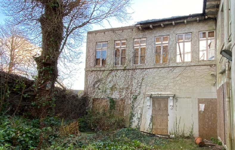
A photograph showing a large, dilapidated two-story building with boarded windows and overgrown vegetation, likely a former commercial or public building.A photograph showing the rear elevation of a property featuring a flat-roofed extension with boarded windows and an overgrown garden area.
2.0 Planning context Area Plan for the East
2.1 The site lies within an area designated on the Area Plan for the East which was adopted in 2020, as Predominantly Residential. Douglas is the principal settlement which will remain the main employment and services centre for the Island (Spatial Policy 1 of the Strategic Plan).
2.2 There are no constraints applicable to this site, shown on any of the plans associated with the Area Plan.
2.3 The site is within the Woodbourne Road Conservation Area although the building itself is not Registered. The Appraisal which accompanies the Conservation Area designation discusses the Georgian, Regency, Victorian, Edwardian and Arts and Crafts inspired buildings. No mention is made of Africa House.
2.4 There are three Registered Trees at the front of the site - two Tilia (Linden) and one Aesculus hippocastanum (European Horse Chestnut).
The Strategic Plan
2.5 The Strategic Plan states that “the focus of development will continue to be in and around Douglas. The current policy of constraining further greenfield development has aided the process of regeneration within the existing urban area. In terms of the Island Spatial Strategy (ISS) for Douglas and the East, the key elements are:
• continued regeneration within Douglas, particularly around the Promenades and Quayside and Douglas Regeneration Area to create further housing, employment, retail and leisure opportunities…
2.5 This sets out strategic policies which apply Island-wide.
2.6 There are policies which promote sustainable development within settlements and which minimise the reliance on the private motor car (Strategic Policies 1, 2 and 10, Spatial Policy 5 and Transport Policy 1).
2.7 There are policies which recommend high standards of design and finish and development which enhances the environment (Strategic Policies 3 and 5, General Policy 2 and Environment Policy 42).
2.8 Development is presumed against which would result in harm to historic fabric and character (Strategic Policy 4).
2.9 Development is encouraged which makes the best use of sites (Strategic Policy 1).
2.10 The Strategic Plan and Planning Policy Statement 1/01 - Conservation of the Historic Environment of the Isle of Man both contain policies which protect the character and appearance of Conservation Areas and where development must either preserve or enhance the character or appearance thereof and take into account the special character of the CA in the determination of any application for development (Environment Policy 35 and CA/2) and any important views into or out of a Conservation Area (Environment Policy 36).
2.11 In addition the demolition of buildings which make a positive contribution to the CA is presumed against (Environment Policy 39 and Planning Policy Statement 1/01 - Conservation of the Historic Environment of the Isle of Man CA/6). The PPS also explains that “Similar criteria will be applied as those outlined in RB/6 above, when assessing the application to demolish the building, but in less clear cut cases, for example, where a building could be said to detract from the special character of the area, it will be essential for the Department to be able to consider the merits of any proposed new development when determining whether consent should be given for the demolition of an unregistered building in a conservation area.” The full wording of RB/6 is set out in Appendix One to this document.
2.12Development is expected to have an acceptable impact on the living conditions of those in adjacent property (General Policy 2 and the Residential Design Guide).
2.13 General Policy 2 sets out general standards of development which should be satisfied: Development which is in accordance with the land-use zoning and proposals in the appropriate Area Plan and with other policies of this Strategic Plan will normally be permitted, provided that the development:
(a) is in accordance with the design brief in the Area Plan where there is such a brief;
(b) respects the site and surroundings in terms of the siting, layout, scale, form, design and landscaping of buildings and the spaces around them;
(c) does not affect adversely the character of the surrounding landscape or townscape;
(d) does not adversely affect the protected wildlife or locally important habitats on the site or adjacent land, including water courses;
(e) does not affect adversely public views of the sea;
(f) incorporates where possible existing topography and landscape features, particularly trees and sod banks;
(g) does not affect adversely the amenity of local residents or the character of the locality;
(h) provides satisfactory amenity standards in itself, including where appropriate safe and convenient access for all highway users, together with adequate parking, servicing and manoeuvring space;
(i) does not have an unacceptable effect on road safety or traffic flows on the local highways;
(j) can be provided with all necessary services;
(k) does not prejudice the use or development of adjoining land in accordance with the appropriate Area Plan;
(l) is not on contaminated land or subject to unreasonable risk of erosion or flooding;
(m) takes account of community and personal safety and security in the design of buildings and the spaces around them; and
(n) is designed having due regard to best practice in reducing energy consumption.
2.14 The loss of woodland - not specifically individual trees - of amenity value is presumed against (Environment Policy 3).
2.15 Development which is harmful to ecology is subject to a specific policy (Environment Policy 4).
3.0 Planning history
3.1 The site has been the subject of a number of applications for alterations and extensions including the following:
IDO 56490 and 55945 - two storey extension (that which is to be reconstructed in this application) - permitted. The footprint of the swimming pool appears on these drawings.
88/00668/B - conversion and extension of existing garage block into garage and offices and construction of new garage block - permitted 94/01764/B - extension to create garage, office, reception and toilets - permitted 98/01421/A - approval for change of use of whole building to offices with directors’ living accommodation - refused
11/01463/B - roof light and window alterations and creation of temporary office and associated staff accommodation (five years) - permitted
11/01464/B - erection of first floor extension - permitted (this was over the conservatory on the south western elevation and was not implemented)
12/00046/B - erection of replacement garage block with living accommodation - permitted
3.2 The Homefield site alongside was approved for redevelopment including the demolition of the existing building and its replacement with a 73 bed nursing home and associated works under 19/00959/B and 19/0960/CON.
3.3 The residential development to the rear - Africa Court (9 dwellings) was approved under 01/00504/B with a further two apartments and four garages added under 01/0145/B.
3.4 The Maples was a redevelopment of a block of existing flats on 85 and 87, Woodbourne Road, on the other side of the road with a terrace of 6 dwellings (02/00186/B).
4.0 The proposal
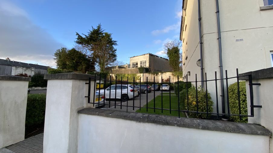
A street-level photograph showing a driveway with parked cars, a white boundary wall with a black metal fence, and a building in the background.
4.1 This application seeks planning approval for the demolition of the later, 1980s rear annex which accommodated a library, store, music room, dining room, gym, games room and store on the ground floor with bedrooms above together with the reconstruction of this extension to replicate what existed prior to the fire and rebuilding the existing fabric which remains. Registered Building Consent is contemporaneously being sought for this demolition as the site lies within a Conservation Area.
4.2 Planning approval is required for the demolition of part of a building if the part of the building in question is visible on an elevation of the building as seen from any highway which bounds the curtilage of the building. As such, this application seeks permission for not only the construction of the replacement extension but also the demolition of the building as the extension is currently visible from Salisbury Street and Murray’s Road.
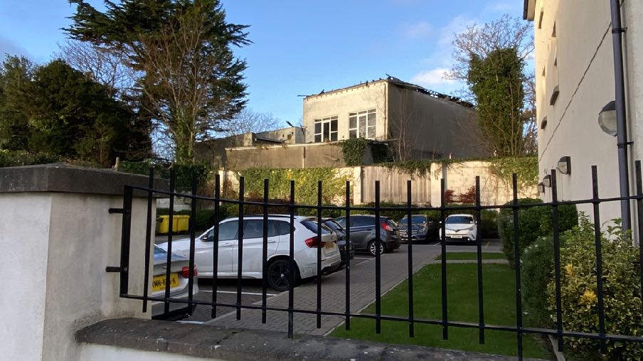
Current view from Salisbury Street
Current view from Murray’s Road
4.3 The reconstruction will incorporate the reconstruction of the stone retaining wall on the boundary with Homefield with the new building set back slightly further (200mm) from this boundary feature than at present.
4.4 The demolition will leave a small number of elements of the existing building exposed where they were previously contained within the external envelope. These are: the door from the relaxation room at the rear of the swimming pool into the existing extension, the door from the swimming pool into the existing extension - both on the ground floor and two kitchen doors on the first floor. The newly exposed side of the existing building which is to be retained will be temporary lined with openings temporarily filled and all made waterproof until the extension is constructed as shown in drawing PD13. As the property is not occupied, it is intended that these will be blocked up until such times as the extension is reconstructed and they again become internal doorways.
4.5 It is not yet known who will undertake any approved demolition and as such it is also not known how the works will be undertaken. There is clearly an access into the site from the public highway and an area alongside where vehicles could park.
A photograph taken through a wire fence showing an overgrown rear plot with a pile of rubble and a white house in the background.
4.6 All existing trees will be protected during the demolition and construction works and again, the exact manner of protection will be a matter for the contractor who will liaise with the appropriate authorities to ensure that appropriate arboricultural and ecological measures are in place. The trees and their canopies are shown on drawing PP02 noting that much of the canopy spreads shown on the drawing already extend over areas of hard surfaced access ways.
5.0 Assessment
5.1 The site is highly sustainable, within the Island’s principal settlement and within convenient and safe walking distance of significant amenities, employment and services. It is within a Conservation Area and the building is clearly one of the oldest in the immediate area. The building has been unoccupied for some time, having been the subject of vandalism and a serious fire and would benefit from renovation and occupation. The principle of the replacement of the rear annex and the resultant ability for the building to be occupied and used, should be considered in accordance with Strategic Policies 1, 2, 3, 4, 5 and 10, Spatial Policies 1 and 5, Housing Policy 4 and Transport Policy 1.
5.2 The issues for this application for planning approval for the demolition of the rear annex and reconstruction are considered to be
• the acceptability of the demolition of the existing extension (Environment Policy 39 and CA/6) and the impact of this on the character and appearance of the Woodbourne Road Conservation Area (Environment Policy 35 and CA/2) or any important view into or out of it (Environment Policy 36)
• The acceptability of the reconstruction of the existing annex and its impact on the special character and the appearance of the Conservation Area (Environment Policies 35 and 36 and Planning Policy Statement 1/01 - Conservation of the Historic Environment of the Isle of Man CA/2).
• The impact on the existing Registered Trees within the site (General Policy 2 and Environment Policy 3).
• The impact of the development on the living conditions of those in adjacent property (General Policy 2 and the Residential Design Guide).
Demolition
5.3 It is clear that there is a presumption against the loss of fabric of importance or significance where a site lies within a Conservation Area although it is submitted that these works do not result in the total or substantial demolition of a registered building or indeed the total or substantial loss of the building as a whole, which is not Registered as is referred to in RB/6 of the Planning Policy Statement: it is solely concerned with a section at the rear of the building.
5.4 Despite the building lying within the Woodbourne Road Conservation Area, there is no mention of Africa House within the CA Appraisal, despite a reference to its younger neighbour, Homefield. It is therefore even more relevant that Registered Building Consent and planning approval were granted for the demolition and replacement of Homefield, seemingly without any adverse comment, or any comment at all about the loss of what could have been considered an historic building worthy of note in the CA Appraisal.
5.5 Notwithstanding the lack of reference in the CA Appraisal, Africa House is clearly within the Conservation Area and is visible therefrom although, sitting lower than Woodbourne Road and the existing, non original entrance, it is not what could be considered prominent within the CA with the elements to be demolished, even less so.
5.6 Furthermore, the historical changes to the building in terms of extensions and alterations and importantly changes to the surrounding area have changed not only the building itself but its context. They have reduced the size of the curtilage and landscaped setting of Africa House, together with the removal of the principal entrance and approach to the building. They have removed any public appreciation or complete view of the original entrance to the building with, for all intents and purposes, the principal entrance to the building appearing to be one visible from Woodbourne Road and on the north western, effectively originally side elevation. In addition, the original principal entrance now has a modern conservatory alongside which unbalances the south western elevation with no appreciable entrance space in front of it. The building is no longer presented as it originally was and was intended to be and the property no longer has the grandeur and status it once had.
5.7 The proposed demolition works are confined to the much more recent, 1980s addition to the building and, it is submitted, its removal would not have any harmful impact on the building itself nor its setting within the Woodbourne Road Conservation Area.
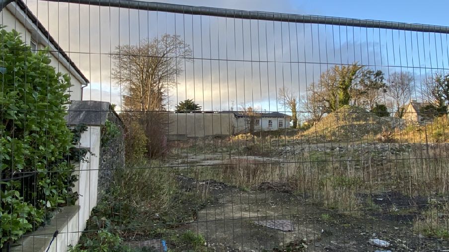
5.8 Historically, this later section of the building has no importance to the original architectural concept of the building and therefore its removal will have no adverse impact on the importance or architectural integrity of the remaining building. From the rear, the absence of this section of the building as viewed from Salisbury Street could be considered beneficial - seen by most viewers at a distance of over 30m and seen above a stone wall in the context of an urban car park serving the modern care home alongside and noting that
this viewpoint is not within any Conservation Area and is not considered to be either an important view into or out of one.
5.9 At present it appears as a flat roofed annex as the hipped roof is missing and both its demolition and its reconstruction complete with roof, would improve its appearance. Similarly, from Murray’s Road, the current appearance is of a poor quality flat roofed building which would be better either not there or reconstructed in its former form prior to the fire.
5.10 It is our position that the demolition of the existing rear fire damaged annex to Africa House has no adverse impact on the character and appearance of the Conservation Area nor those of Africa House, nor any adverse impact on any views, important or otherwise, into or out of the Conservation Area and therefore the proposal accords with Environment Policies 35, 36 and 39 and Planning Policy Statement 1/01 - Conservation of the Historic Environment of the Isle of Man RB/6 and CA/2.
Reconstruction of extension
5.11 The principal test for a development within a Conservation Area, as set out in both EP35 and CA/2 is whether taking into account the special character of the CA, whether the development preserves or enhances the character and appearance of the Area.
A street-level photograph showing a parking area with cars behind a black metal fence, with a two-story building structure visible in the background.
5.12 In this case, the current proposal is to reconstruct the rear annex as it was prior to the fire in 2023. From Woodbourne Road, the extension is visible but not prominent and certainly when the trees are in leaf is not visible. From within the site the majority of the extension is visible from in front of the roadwork facing elevation:
5.13 From Salisbury Street and Murrays Road the extension is visible but some distance from the viewer and in both cases would benefit the street scene if it were reconstruction and complete rather than in its current condition.
5.14 The proposal is to reconstruct the extension as it previously appeared: in essence compared with what exists, all that would change from that is the reinstatement of the roof which is currently missing and the walling and windows would be new and in good order.. Whilst the proposal is to set the new extension back from the boundary wall with Homefield by 200mm, we would suggest that this change is imperceivable to most and certainly would not be noticeable or result in any harmful appearance as viewed from outside the site.
5.15 The character and appearance of the Conservation Area would therefore be preserved and arguably, as the restoration of this part of the building would enable the re-use and
A photograph of a large, dilapidated two-story building with boarded windows and overgrown vegetation, likely a former commercial or public structure.
occupation of the building which would improve its current appearance and re-energise an existing building within a highly sustainable location the proposal will enhance it, noting that the site is not referred to at all in the Conservation Area Appraisal thus satisfying Strategic Policies 3 and 4 and Environment Policies 35 and 36 and CA/2.
5.16 Similarly, setting aside the fact that the site is within a Conservation Area, the slightly less onerous tests of the Strategic Plan in Strategic Policies 3 and 5, General Policy 2 and Environment Policy 42 require that development has an acceptable impact on its environment, taking account of the particular character and identity, in terms of buildings and landscape features of the immediate locality and resulting in a positive impact or simply that it does not have a negative impact thereon.
5.17 In reinstating what currently exists but adding back in the roof, and taking into account the fact that this rear section is not prominent and to most passers by, not visible at all, what is proposed is considered to accord with all of these policies and again will allow the renovation of the rest of the building and its use, all benefiting the area generally.
Impact on trees and Registered Trees
5.18 The proposal will have no impact on existing trees and landscaping, noting that a licence would be required for the removal of any trees, particularly those which are Registered. Whilst the works themselves do not involve any potential harm to these trees and others on the site, it is accepted that access will be require for demolition vehicles and equipment. The submitted plans show the canopy spread of the existing trees on site which will be protected as far as is practicable but also noting that existing hardstanding areas and driveway exist and it is not envisaged that any new areas of hardstanding will be required to implement the demolition or reconstruction. It will be for the contractor appointed to decide how and from where the works will be undertaken and it would be acceptable for a condition to be attached to any approval of this application, requiring the submission and approval of a further construction method statement showing where any plant and parking together with site compounds would be located and how the trees would be protected with the development implemented in accordance with these details.
Impact on adjacent neighbours
5.19 The proposal will reinstate what formerly existed with, in essence the proposal merely reinstating the roof which was removed following the fire damage in 2023. The proposal will have no different impact on those in adjacent property compared with the former situation.
5.20 The rear section facing Homefield, neither contained nor is proposed to have any first floor windows in its rear elevation which could afford a view into either the Homefield site or the care home. The nearest residential properties are within Africa Court which are approximately 17m away at the closest points (to the rear flat roof which is accessed from the first floor bedroom doors) and with no windows which look directly toward each other. There is also significant vegetation between the two sites which prevents any intervisibility. The current situation appears to allow access from the first floor onto an area of flat roof although there are no balustrades around this area. It is proposed to install Juliet balconies in front of these large openings to precent access onto the flat roofed area, thus improving the relationship of Africa House with the closest buildings to it.
5.21 The proposal is therefore considered to have an acceptable impact on the living conditions of those in adjacent residential property, according with General Policy 2 and the Residential Design Guide.
Other matters
5.22 Prior to the submission of the application, we contacted the Ecosystems Policy Office regarding the potential impact on ecology, which we felt would be low and the level of information which would be required. They advised that:
“Looking at the fire damage, I would say that the potential for bats in that part of the building is negligible, though if you’re going to impact the adjacent heavily ivy clad tree, bats should be a consideration. Again some photos would help. There could possibly be some potential for birds, with the most likely location being the ivy on the south side of the building, but again because of the damage, the potential in the building is low. If you’re looking for demolition to take place in the breeding bird season, my advice would be to cut back the ivy over the winter so birds can’t nest. Checks inside before demolition should also take place. I would say definitely no to lizards as the site is too isolated from other habitat in the middle of Douglas and the habitat itself isn’t really suitable.” Below are photographs of the section of the building in question and we confirm that it is not proposed to remove any trees as part of the proposal. If this becomes necessary then the appropriate checks and consultations and permissions if required, will be sought.
5.23 It has not been possible due to the condition of the building to provide photographs of the inside of the extension to be demolished but it is clear from the photographs provided
above that the roof is missing and the building exposed to the elements. It is hoped that the extension can be demolished prior to the bird nesting season but the advice from Ecosystems Policy Office is noted and the appropriate steps will be undertaken.
Conclusion
5.24 It is our position that the proposal has no harmful impact on the surrounding area and accords fully with the relevant Strategic and Area Plan policies and proposals and supporting guidance identified above. The works will at least preserve, if not enhance the character and appearance of the Conservation Area and as such accord with the requirements of Planning Policy Statement 1/01 - Conservation of the Historic Environment of the Isle of Man.
5.25 The works will enable the application to proceed with the restoration of this property and enable this highly sustainable site to once more contribute to the city through its occupation and use, contributing functionally and visually to the appearance and vitality to the city and adding to the housing stock within the Island’s principal settlement.
5.26
Sarah Corlett 09.12.24
A photograph showing a dilapidated two-story rear extension with boarded windows and ivy-covered walls.
Appendix One
EXCERPT FROM Planning Policy Statement 1/01 - Conservation of the Historic Environment of the Isle of Man
POLICY CA/2 SPECIAL PLANNING CONSIDERATIONS When considering proposals for the possible development of any land or buildings which fall within the conservation area, the impact of such proposals upon the special character of the area, will be a material consideration when assessing the application. Where a development is proposed for land which, although not within the boundaries of the conservation area, would affect its context or setting, or views into or out of the area; such issues should be given special consideration where the character or appearance of a conservation area may be affected.
POLICY RB/6 DEMOLITION There will be a general presumption against demolition and consent for the demolition of a registered building should not be expected simply because redevelopment is economically more attractive than repair and re-use of an historic building; or because the building was acquired at a price that reflected the potential for redevelopment, rather than the condition and constraints of the existing historic building. Where proposed works would result in the total or substantial demolition of a registered building, an applicant, in addition to the general criteria set out in RB/3 above, should be able to demonstrate that the following considerations have been addressed:-
In judging the effect of any proposed alteration or extension to a Registered Building, it is essential to have assessed the elements that make up the special interest of the building in question. They may comprise not only obvious features such as a decorative facade, or an internal staircase or plaster ceiling, but may include the spaces and layout of the building and the archaeological or technological interest of the surviving structure and surfaces. These elements can be just as important in the simple vernacular and functional buildings, as in grander status buildings. Cumulative changes reflecting the history of use and ownership can themselves present an aspect of the special interest of some buildings, and the merit of some new alterations or additions, especially where they are generated within a secure and committed long-term ownership, are not discounted.
The destruction of historic buildings is in fact very seldom necessary for reasons of good planning: more often it is the result of neglect, or failure to make imaginative efforts to find new uses or incorporate them into new developments.
• The condition of the building, the cost of repairing and maintaining it in relation to its importance and to the value derived from its continued use. Any such assessment should be based on consistent and long term assumptions. Less favourable levels of rents and yields cannot automatically be assumed for historic buildings and returns may, in fact, be more favourable given the publicly acknowledged status of the building. Furthermore, historic buildings may offer proven performance, physical attractiveness and functional spaces, that in an age of rapid change, may outlast the short-lived and inflexible technical specifications that have sometimes shaped new developments. Any assessment should take into account possible tax allowances and exemptions. In rare cases where it is clear that a building has been deliberately neglected in the hope of obtaining consent for demolition, less weight should be given to the costs of repair;
• The adequacy of efforts made to retain the building in use. An applicant must show that real efforts have been made, without success, to continue the present use, or to find new uses for the building. This may include the offer of the unrestricted freehold of the building on the open market at a realistic price reflecting the building’s condition.
• The merits of alternative proposals for the site. Subjective claims for the architectural merits of a replacement building should not justify the demolition of a registered building. There may be very exceptional cases where the proposed works would bring substantial benefits for the community; these would have to be weighed against preservation. Even here, it will often be feasible to incorporate registered buildings within new development, and this option should be carefully considered. The challenge presented by retaining registered buildings can be a stimulus to imaginative new designs to accommodate them.
APPENDIX TWO
Relevant Strategic Plan policies
Strategic Policy 1: Development should make the best use of resources by:
(a) optimising the use of previously developed land, redundant buildings, unused and under-used land and buildings, and reusing scarce indigenous building materials;
(b) ensuring efficient use of sites, taking into account the needs for access, landscaping, open space(1) and amenity standards; and
(c) being located so as to utilise existing and planned infrastructure, facilities and services.
Strategic Policy 2: New development will be located primarily within our existing towns and villages, or, where appropriate, in sustainable urban extensions(2) of these towns and villages. Development will be permitted in the countryside only in the exceptional circumstances identified in paragraph 6.3.
Strategic Policy 3: Proposals for development must ensure that the individual character of our towns and villages is protected or enhanced by:
(a) avoiding coalescence and maintaining adequate physical separation between settlements; and
(b) having regard in the design of new development to the use of local materials and character.
Strategic Policy 4: Proposals for development must:
(a) Protect or enhance the fabric and setting of Ancient Monuments, Registered Buildings(1), Conservation Areas(2) , buildings and structures within National Heritage Areas and sites of archaeological interest;
(b) protect or enhance the landscape quality and nature conservation value of urban as well as rural areas but especially in respect to development adjacent to Areas of Special Scientific Interest and other designations; and
(c) not cause or lead to unacceptable environmental pollution or disturbance.
Strategic Policy 5: New development, including individual buildings, should be designed so as to make a positive contribution to the environment of the Island. In appropriate cases the Department will require planning applications to be supported by a Design Statement which will be required to take account of the Strategic Aim and Policies.
Strategic Policy 10: New development should be located and designed such as to promote a more integrated transport network with the aim to: (a) minimise journeys, especially by private car; (b) make best use of public transport; (c) not adversely affect highway safety for all users, and (d) encourage pedestrian movement.
Spatial Policy 1: The Douglas urban area will remain the main employment and services centre for the Island.
Spatial Policy 5: New development will be located within the defined settlements. Development will only be permitted in the countryside in accordance with General Policy 3.
Environment Policy 3: Development will not be permitted where it would result in the unacceptable loss of or damage to woodland areas, especially ancient, natural and semi-natural woodlands, which have public amenity or conservation value.
Environment Policy 35: Within Conservation Areas, the Department will permit only development which would preserve or enhance the character or appearance of the Area, and will ensure that the special features contributing to the character and quality are protected against inappropriate development.
Environment Policy 36: Where development is proposed outside of, but close to, the boundary of a Conservation Area, this will only be permitted where it will not detrimentally affect important views into and out of the Conservation Area.
Environment Policy 39: The general presumption will be in favour of retaining buildings which make a positive contribution to the character or appearance of the Conservation Area.
Environment Policy 42: New development in existing settlements must be designed to take account of the particular character and identity, in terms of buildings and landscape features of the immediate locality. Inappropriate backland development, and the removal of open or green spaces which contribute to the visual amenity and sense of place of a particular area will not be permitted. Those open or green spaces which are to be preserved will be identified in Area Plans.
Housing Policy 4: New housing will be located primarily within our existing towns and villages, or, where appropriate, in sustainable urban extensions(1) of these towns and villages where identified in adopted Area Plans: otherwise new housing will be permitted in the countryside only in the following exceptional circumstances:
(a) essential housing for agricultural workers in accordance with Housing Policies 7, 8, 9 and 10;
(b) conversion of redundant rural buildings in accordance with Housing Policy 11; and
(c) the replacement of existing rural dwellings and abandoned dwellings in accordance with Housing Policies 12, 13 and 14.
Transport Policy 1: New development should, where possible, be located close to existing public transport facilities and routes, including pedestrian, cycle and rail routes.
Copyright in submitted documents remains with their authors. Request removal
Source & Provenance
Official reference
24/91384/B
Source authority
Isle of Man Government Planning & Building Control