Planning Statement In Support Of The Erection Of Three Polytunnels, Field 214317, Ballachrink Farm, Ballachrink Lane, Jurby
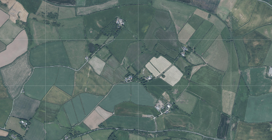
Aerial view of a rural landscape showing agricultural fields and hedgerows, likely a site location map with a grid overlay.
1.0 INTRODUCTION
1.1 The site is a single field of approximately 1.2ha which sits on the north western side of a private lane - Ballachrink Lane, which runs north east from the Jurby East Road (B3). The field has a single access from the private lane which is gated. The field is presently not actively used. The applicant also owns field 210199 which accommodates a copse of trees in the southern corner of the field. This is shown in blue as it forms no part of the proposed development.
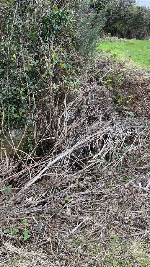
1.2 The field has a ditch running around the north west and northern edges of the field:
1.3 At the time of the site visit (early November, 2024) there was a little water in the ditch but it was not flowing. There was evidence of damp conditions with small area of reeds within the grassland and some of the field was wet underfoot.
1.4 The boundaries of the field are formed by a variety of self seeded trees, some of which have significant areas of ivy coverage along with willow, blackberries and gorse.
1.5 The field abuts the copse to the south which is owned by the applicant but is not part of the application site.
2.0 THE PROPOSAL
2.1 The proposal is for the erection of three polytunnels on the site. It is the applicant’s intention to firstly install one polytunnel and in time and when resources allow, to erect up to two further polytunnels.
2.2 The site will be largely used for grazing of animals - starting with a small number of chickens and ducks with a view to having sheep, pigs, goats in time as well as possibly bee hives and the growing of fruit and vegetables. Essentially it is intended to create a small holding for one family to provide for themselves but with sales or bartering of any excess. Due to the nature of the ground and the applicant’s desire not to undertake significant drainage or engineering operations as she wishes to retain the field as much as existing as possible, she wishes to be able to undertake planting in a sheltered environment and where she can provide appropriate soil and planting conditions.
2.3 The polytunnels will be positioned as shown in the plans and placed straight onto the ground with a strip of bark or chipping around them to provide for a more stable surface for access and precent any strimmer getting to close to the plastic cover: they are not to be any foundations and if and when the polytunnels are not needed, they can be removed and the field returned to its current condition. The polytunnels will allow productive use of the site without permanently affecting its quality or basic soil structure.
2.4 Prior discussions with Department of Environment, Food and Agriculture Fisheries has led to the polytunnels being sited in excess of 5m from the ditch (it was recommend to have at least 4m to allow biological activity on any nutrient rich leachates from any intensive gardening activities in the polytunnel and ideally leaving land between the ditch and polytunnel overgrown and roughly maintained which will protect watercourses connected to this ditch network from high nutrient loading runoff). The applicant is happy to do this as her intention is not only to grow vegetables and fruit here but also to protect and ideally enhance the biodiversity of the field and surrounding area through maintaining a wildlife corridor to the edfe of the field, using natural products rather than artificial fertilisers and pesticides, the installation of bird and bat boxes in time, following specialist advice and work the land in a non intensive way. Additional planting to reinforce existing hedging and vegetation will involve local species - hawthorn, blackthorn, holly, elder and fuchsia and will be considered in time and as required/desirable.
2.5 No changes are proposed to the access, to the site or to the adjacent copse which is identified as being of ecological interest on the draft Area Plan for the North and West.
3.0 Planning Policy Context
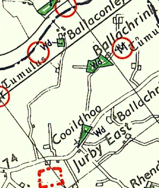
A map extract showing the site location in Jurby with nearby features like tumuli highlighted in red circles and the proposed site boundary marked with a red dashed square.
Isle of Man Planning Scheme (Development Plan) Order 1982
3.1 The only adopted development plan for this part of the Island is the Isle of Man Planning Scheme(Development Plan) Order 1982. This designates the site as not for a particular purpose and not as ofan area of High Landscape or Coastal Value and Scenic Significance. There are no other constraintsshowing as applicable to this site.
Draft Area Plan for the North and West (DAPNW)
3.2 Cabinet Office is in the process of preparing a development plan which will cover the northernand western half of the Island - the other half already covered by the Area Plans for the South (2013)and East (2020). The DAPNW was the subject of a public inquiry in July 2024 and the inspector’sreport was received in October 2024 and published in November, 2024. The next stage is for CabinetOffice to adopt the plan, with or without modifications following the inspector’s recommendations,publish that for consultation then proceed to Tynwald for adoption.
3.3 The DAPNW confirms the status of the site as not designated for a particular purpose but includes Constraints maps which are helpful in identifying particular known sensitivities and issues for potential development.
3.4 The Environmental Constraints Map identifies the copse within the applicant’s ownership as being an area of ecological interest.
3.5 The Infrastructural Constraints Map does not show the site as being subject to any critical issues. Whilst this map included an area for the protection of Jurby Airfield for future expansion as a potential airport, this did not extend as far as the application site but in any case has been recommended for exclusion from the plan by Cabinet Office at the public inquiry and this was acknowledged by the inspector in his report (paragraphs 160-163 and his recommended major changes RMCs 15 and 76).
3.6 The DAPNW introduces the Landscape Character Assessment which was commissioned by the Department and published in 2008. Whilst never adopted in its fullest form (and except of which is provided at Appendix One to this document), the Area Plan refers to and summarises it as follows:
6.4.3 The Undulating Lowland Plain of Andreas and Jurby (F3) encompasses a swathe of farmland underlain by the predominantly flat topography of the northern plain. To the west, the narrow course of the Lhen trench meanders through the landscape. The main
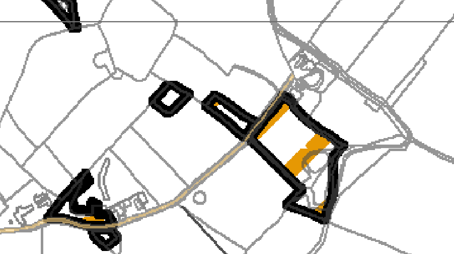
A digital site plan showing field boundaries, roads, and black outlines of structures with a highlighted yellow section.
A19 and A17 roads cross the area interlinking with a network of minor roads often lined with tall Manx sod banks. Settlement pattern is scattered and relatively isolated with the Andreas and Jurby Industrial Estates and IOM prison providing the largest groups of buildings within the area.
Overall, there is a strong sense of tranquillity and openness. A strong recognisable sense of place is provided by views to the dramatic backdrop of the Uplands to the south, views of St. Patrick’s Church and distant views to the sea at the eastern and western edges of the area.
Landscape Strategy
To conserve and enhance:
a) the character, quality and distinctiveness of this rural area including the scattered settlement pattern, relatively strong field pattern delineated by a mixture of stone walls and relatively tall Manx hedge-banks and its network of enclosed minor rural roads
Key Views
• Glimpsed views to the sea from the eastern and western edges of the area.
• Panoramic open views southwards towards a dramatic upland backdrop.
• Open views to landmark church towers (particularly St. Patrick’s Church) to the west of Jurby.
Landscape Proposal 7 The established wooded character of the Sulby River Lhen Trench and surrounding area which affords channelled views within the landscape shall be preserved.
Development proposals must demonstrate that the impacts upon landscape character have been considered, and the design of any future proposal is adequately sympathetic to, and informed by the established landscape character.
Dramatic views to the adjacent southern uplands shall not be impaired.
Isle of Man Strategic Plan 2016
3.7 The Strategic Plan is largely non geographical other than identifying a settlement hierarchy and provides over-arching guidance on development throughout the Island.
3.8 There is a presumption against development in areas not designated for such although General Policy 3 provides a list of exceptions, including “f. Building and engineering operations which are essential for the conduct of agriculture or forestry”.
3.9 Environment Policy 1 presumes against development which is harmful to the countryside.
3.10 Environment Policy 15 provides further guidance on development for agricultural or horticultural purposes (“agriculture” includes horticulture in the definition of development in the Town and Country Planning Act 1999 (section 45):
Where the Department is satisfied that there is agricultural or horticultural need for a new building (including a dwelling), sufficient to outweigh the general policy against development in the countryside, and that the impact of this development including buildings, accesses, servicing etc. is acceptable, such development must be sited as close as is practically possible to existing building groups and be appropriate in terms of scale, materials, colour, siting and form to ensure that all new developments are sympathetic to the landscape and built environment of which they will form a part.
Only in exceptional circumstances will buildings be permitted in exposed or isolated areas or close to public highways and in all such cases will be subject to appropriate landscaping. The nature and materials of construction must also be appropriate to the purposes for which it is intended.
Where new agricultural buildings are proposed next to or close to existing residential properties, care must be taken to ensure that there is no unacceptable adverse impact through any activity, although it must be borne in mind that many farming activities require buildings which are best sited, in landscape terms, close to existing building groups in the rural landscape.
3.11 Land which comprises high quality soil will be protected from loss (Environment Policy 14). In this case the soil appears to be Class 3 and as such, not especially protected. In any case, there is no disturbance to the soil so no loss.
3.12 Ecology is protected through Environment Policies 4 and 7:
Environment Policy 4: Development will not be permitted which would adversely affect:
(a) species and habitats of international importance:
(i) protected species of international importance or their habitats; or
(ii) proposed or designated Ramsar and Emerald Sites or other internationally important sites.
(b) species and habitats of national importance:
(i) protected species of national importance or their habitats; (1) Wildlife Sites are defined in Appendix 1 41
(ii) proposed or designated National Nature Reserves, or Areas of Special Scientific Interest; or
(iii) Marine Nature Reserves; or
(iv) National Trust Land.
(c) species and habitats of local importance such as Wildlife Sites, local nature reserves, priority habitats or species identified in any Manx Biodiversity Action Plan which do not already benefit from statutory protection, Areas of Special Protection and Bird Sanctuaries and landscape features of importance to wild flora and fauna by reason of their continuous nature or function as a corridor between habitats.
Some areas to which this policy applies are identified as Areas of Ecological Importance or Interest on extant Local or Area Plans, but others, whose importance was not evident at the time of the adoption of the relevant Local or Area Plan, are not, particularly where that plan has been in place for many years. In these circumstances, the Department will seek site specific advice from the Department of Agriculture, Fisheries and Forestry if development proposals are brought forward.
Environment Policy 7: Development which would cause demonstrable harm to a watercourse, wetland, pond or dub, and which could not be overcome by mitigation measures will not be permitted. Where development is proposed which would affect a watercourse, planning applications must comply with the following criteria:
(a) all watercourses in the vicinity of the site must be identified on plans accompanying a planning application and include an adequate risk assessment to demonstrate that works will not cause long term deterioration in water quality;
(b) details of pollution and alleviation measures must be submitted;
(c) all engineering works proposed must be phased in an appropriate manner in order to avoid a reduction in water quality in any adjacent watercourse; and
(d) development will not normally be allowed within 8 metres of any watercourse in order to protect the aquatic and bankside habitats and species.
4.0 PLANNING HISTORY
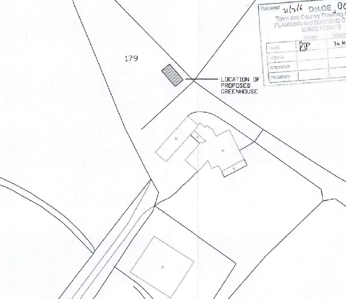
4.1 The site itself has not been the subject of any previous applications. As part of Ballachrink Farm it was included in applications for development which were not on the site itself. These applications include alterations and extensions to the farmhouse, conversion of outbuildings to tourist and residential accommodation, erection of stables and outbuildings including a greenhouse. None of these is considered relevant to the current proposal: whilst the application for the greenhouse was refused, this was rejected for the rather unusual reason that:
The application is incorrect in that the location of the greenhouse has since changed following the submission of the application to the Department. The greenhouse has since been erected in its new location therefore it would be inappropriate to grant permission for a different location as this would be misleading for the applicant and the general public.
4.2 There was no discussion or assessment of the actual impact of the greenhouse which was shown to be erected in the small triangle to the north west of the farmhouse and outbuildings.
A black and white site plan showing the location of a proposed greenhouse relative to existing buildings and property boundaries.
4.3 The access road was permitted to be concreted under 02/00467/B.
4.4 Other applications for polytunnels include the following:
24/90981/B - erection of polytunnel and micro wind turbine, Lambfell Beg, Cronk y Voddy, German - permitted 23/01461/B - erection of polytunnels (partially retrospective), Red Mie, Bollyn Road, Ballaugh - permitted 23/01178/B - erection of polytunnel and hardcore entrance, filed 420669, Ronague, Arbory permitted 23/00359/B - erection of polytunnel, workshop and ground mounted solar panels and wildlife pond, Ballacannell, Earystane, Colby - permitted 22/00846/B - erection of polytunnel, Upper Sulby Farmhouse, Scollag Road, Onchan permitted 22/00476/B - erection of three polytunnels, field 430720, Bayrauyr, St. Marks, Ballasalla permitted 22/00173/B - erection of two polytunnels, Glen Villas and field 131682, Ballamanaugh Road, Sulby, Lezayre - permitted
22/00150/B - erection of polytunnel and shed, field 425031, Ronague Road, Ronague, Arbory - permitted. This following a previous unsuccessful application for the erection of an agricultural building which was refused as the Officer was not persuaded that there was agricultural need demonstrated for a building of the proposed size and design sufficient to override the planning policies against development in this location.
22/00007/B - erection of polytunnel, Ballaoates Farm, Ballavargher Road, St. John’s permitted
21/01250/B - erection of polytunnel, tool shed and animal shelter, Ballakeil Meadow, Smeale Road, Andreas - permitted
21/00508/B - erection of polytunnel, field 394209, Creg Lea Farm, Niarbyl, Patrick permitted
4.5 There are more cases which were not considered so relevant as they related to sites which are less directly comparable with this, but nonetheless, with the above cases, demonstrate a presumption that most, if not all applications for polytunnels were considered acceptable.
5.0 ASSESSMENT AND CONCLUSION
5.1 Whilst the site is not designated for development, it is clear from the examples of previous applications for polytunnels which have been permitted, that in most, if not all cases, the principle has been considered acceptable.
5.2 In this case the polytunnels will have no impact on the character or appearance of the countryside as the site is screened on all sides from any view other than from immediately alongside the site on the private lane and even then, the view is either through the gate and for a short section of the site frontage, or through established vegetation. The Landscape Character Assessment sets out key considerations and sensitivities which we believe our proposal will not adversely affect: the existing irregular field pattern and mature hedges will be retained along with the rough grassland and the panoramic views to the south will not be affected at all. The overall strategy to conserve and enhance the character, quality and distinctiveness of this rural area will be supported by the proposal, in our view.
5.3 The polytunnels will be located as far from the private road as possible whilst maintaining an appropriate distance from the ditch, in accordance with the helpful advice provided prior to the submission of the application, from the Fisheries Division of Department of Environment, Food and Agriculture.
5.4 The polytunnels will allow the growing of fruit and vegetables within the site without major intrusion into the soil or field and allowing the majority of the field to remain grazed and unaltered. There is no intention of installing any drainage so any wet habitat will remain as is but intrusive species such as gorse and fern will be managed.
5.5 There is no intention to alter the copse in any way and the amount of comings and goings will be minimal - the applicant only and for very infrequent deliveries of items related to the agricultural use of the site.
5.6 The concreted access road provides a firm and consistent access to the site and whilst narrow, it serves only a small number of properties and the amount of traffic which will be generated by the proposal is minimal. The installation of the polytunnels will allow less frequent visits to ensure the best growing conditions for the fruit and vegetables, thus contributing to a reduction in traffic to and from the site.
5.7 We believe that the proposal satisfies all of the relevant planning policies and will realist in an enhancement to the agricultural productivity of the site and the opportunity for further biodiversity enhancement.
Sarah Corlett 19.11.24
APPENDIX ONE
EXCERPT FROM THE LANDSCAPE CHARACTER ASSESSMENT 2008
F3 ANDREAS AND JURBY Key Characteristics
• Swathe of farmland (covering the breadth of the Island).
• Irregular pattern of medium-sized arable and pasture fields.
• Field boundaries demarcated by traditional Manx hedges and simple post and wire fences.
• Inter-linking network of minor rural roads serve the area, together with the A10, A17 and A19.
• Generally few vertical elements, other than occasional telegraph poles.
• Scattered and relatively isolated settlement pattern.
• Traditional farm buildings (characteristically white, with grey roofs).
• Key settlements include the small town of Andreas and the villages of Bride, Jurby and Sandygate.
• The Isle of Man Government Industrial Estate and adjacent Jurby Aerodrome
• Disused airfield at Andreas
• Churches provide prominent landmarks within views.
• Views to dramatic upland backdrop to the south provide strong sense of place.
• Strong sense of openness and tranquillity (at distance from main A19 and A17 roads).
• Slightly marked sinuous valley of Lhen Trench.
• Sandpit at Cronk-y-Scotty
Overall Character Description Situated to the north of the Island, this landscape character area encompasses a swathe of farmland underlain by the predominantly flat topography of the northern plain.
To the west, the relatively narrow course of the Lhen trench meanders through the landscape, which exhibits an irregular pattern of medium-sized arable fields and rough grassland/pasture. A variety of different forms of hedgerows and simple post and wire fences demarcate field boundaries.
To the west, mature, intact low, trimmed hedges dominate the hedgerow network. Several single mature deciduous trees within Manx hedgerows and fields also contribute to a mature recognisable landscape structure. The main A19 and A17 roads (a source of noise and visual
intrusion) cross the area and an inter-linking network of minor roads, often lined with species-rich verges, help to provide access to farms and settlements.
Generally, few vertical elements punctuate the skyline of the area. However, telegraph poles and the telecommunications mast at Jurby Industrial Estate are a visible human influence. Settlement pattern is scattered and relatively isolated, with the Andreas and Jurby Industrial Estates providing the largest groups of buildings within the area.
Several isolated farmsteads and individual houses also pepper the landscape. Traditional farm buildings characteristically exhibit white walls (which often provide a bright contrast to the muted upland backdrop to the north) and grey roofs. Alongside these traditional buildings, modern agricultural sheds and warehouses are sometimes visually intrusive.
In addition, the distinctive churches of St. Andrews Church at Andreas (built predominantly from Sulby Glen stone) and St. Patrick’s Church to the west of Jurby and their associated medieval crosses are landmark features landscapes within the area. St. Patrick’s Church is particularly prominent within views across the surrounding open, flat landscape.
The prefabricated buildings on an old air force base and disused runway at Jurby (now housing several small businesses and shops, including Jurby Junk) exhibit a strong human influence over the character of this part of the area. Construction of the new prison development is also associated with this part of the area.
Overall, there is a strong sense of tranquillity and openness throughout the area. A strong recognisable sense of place is provided by views to the dramatic backdrop of the Uplands to the south, views of St. Patrick’s Church and distant views to the sea at the eastern and western edges of the area.
Key Views
• Glimpsed views to the sea from the eastern and western edges of the area.
• Panoramic open views southwards towards a dramatic upland backdrop.
• Open views to landmark church towers (particularly St. Patrick’s Church) to the west of Jurby.
Historic Features
• St. Patrick’s Church and medieval crosses.
• St. Andrew’s Church and medieval crosses.
• Old airfields at Jurby and to the east of Andreas.
Ecological Features
• Species-rich verges.
• Mature hedgerows and single mature deciduous trees.
• Patches of rough grassland
• Area of Special Scientific Interest at Ballacrye
Evaluation of Inherent Landscape Sensitivities
• Strong sense of tranquillity.
• Scattered isolated settlement pattern.
• Enclosed minor rural roads.
• Vernacular character of buildings and churches.
• Presence of Manx Milestones.
• Few tall vertical elements.
• Dramatic views south to Uplands.
• Field pattern delineated by a mixture of stone walls, relatively tall Manx hedge-banks and post and wire fences.
Landscape Strategy The overall strategy should be to conserve and enhance the character, quality and distinctiveness of this rural area including the scattered settlement pattern, relatively strong field pattern delineated by a mixture of stone walls and relatively tall Manx hedge-banks and its network of enclosed minor rural roads.
Copyright in submitted documents remains with their authors. Request removal
Source & Provenance
Official reference
24/91315/B
Source authority
Isle of Man Government Planning & Building Control