Planning And Environmental Impact Statement For The Development Of Land For Tourism Incorporating Motorhome Parking, Three Shepherds’ Huts, Shower Block, Reception Building And Area For Tented Camping, Land To The South Of West View, Summerhill Road, Jurby
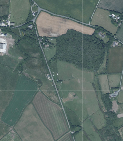
An aerial view of a rural landscape showing fields, hedgerows, and a road, serving as a site location map for the proposed development.
1.0 Introduction
1.1 This statement relates to an area of land which sits towards the northern end of Summerhill Road (B4) and to the south of a residential property, West View, which is also in the applicants’ ownership.
1.2 The site extends to 0.8ha (2 acres) and is currently open, agricultural land with an access onto the B4. Part of the site has historically (up to and including current times) been used by the Isle of Man Motorcaravan Club (IOMMC) for the parking of motorhomes and in fact there are a number of such vehicles shown on the most up to date aerial photograph of the site on the Government website (see above). The IOMMC have been using the site for some time, since at least the 1990s. The site is otherwise used for livestock grazing as part of the remainder of the farmland owned by the applicant.
1.3 The site has trees along the roadside and a small area of trees to the east of the vehicular entrance into the field. There is a small wet area in the north part of the site.
2.0 Planning Policy
2.1 Planning policy takes a number of forms: land is designated for a particular purpose, or not, on an adopted Area or Local Plan (or where there is neither, Isle of Man Planning Scheme (Development Plan) Order 1982). Above this, there is the Isle of Man Strategic Plan 2016 which is not geographic but provides over-arching strategic policies which apply across the Island. Area Plans should be in general conformity with the Strategic Plan but where there is any contradiction of conflict, whichever was adopted later would prevail (paragraph
1.4.4).
2.2 Consideration can also be given in the determination of any planning application, to Planning Policy Statements, Planning Circulars, National Policy Directives (there is none as yet) or other statements of planning policy as well as other Government policies. Planning is a balance of all of these considerations as well as anything else which could be considered a material consideration.
Isle of Man Planning Scheme (Development Plan) Order 1982
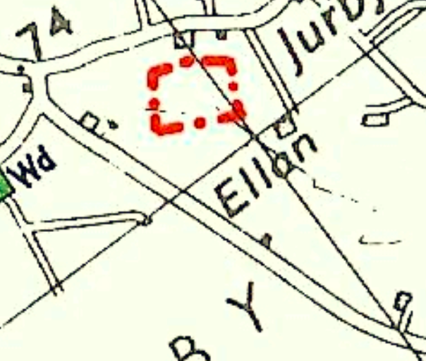
2.3 The site lies within an area designated on the 1982 Plan as not for a particular purpose and outside of the area of an area of High Landscape or Coastal Value and Scenic Significance. There is an area of ecological interest (the red dotted and dashed lines below) to the east of the buildings which is thought to refer to the marshy pond area outwith the land holding:
A site location map showing a red dashed boundary line highlighting the proposed development site near roads labeled Ellan and Jurby.
2.4 The 1982 Plan is in the process of being replaced by a new Area Plan for the North and West. This is in draft form only at this stage and was the subject of a public inquiry in July of this year. On this plan the site is not designated for development. There are also additional maps which reveal environmental and infrastructural constraints.
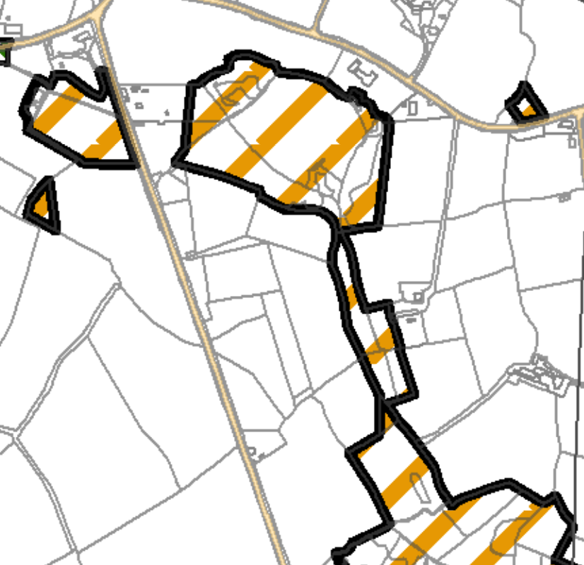
2.5 On the Environmental Constraints Map there is a similar area of ecological importance as seen on the 1982 Plan which does not include any of the proposed site:
A site plan map showing the proposed development area outlined in black with orange diagonal hatching, set against a background of field boundaries and roads.
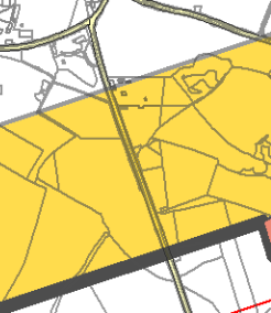
2.6 The Infrastructural Constraints Map shows the site falling within an area marked as “Transition Surface” with a very small section of the site at the southern end falling within the “Runway Strip”. The draft Written Statement includes a section on safeguarding zones for Jurby Airport and refers to these ground level Safeguarding Zones around the airfield in order to protect its future use with a specific proposal:
Transport and Utilities Proposal 5 The Infrastructure Constraints Map 1aN [sic - the Infrastructure Constraints map is 1bN] sets out Safeguarding Zones that are required to protect the future use of Jurby airfield for a potential national airport. No development will be permitted in these zones that would prejudice this use. As these areas are threedimensional, consultation with the Department of Infrastructure (Airport Division) is essential prior to any approval being granted for development within these zones.
A site plan showing land parcels highlighted in yellow with black boundary lines and road networks.
2.7 There is a large area to the south east of the buildings subject to surface water flood risk on the national flood risk maps: this is outwith the application site. There are small areas within the site, alongside the road, shown as being at risk of flooding by surface water.
2.8 There are no Registered Trees on the site, no Registered Buildings and the site is not within a Conservation Area.
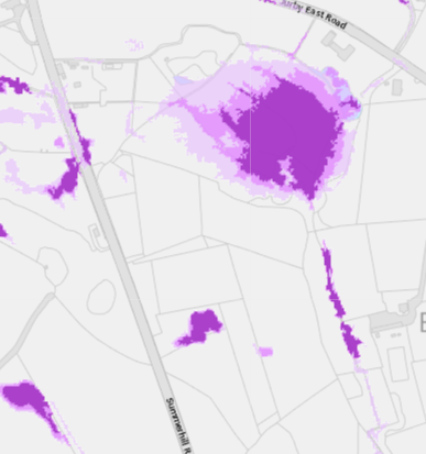
A digital map showing field boundaries and roads with purple highlighted areas indicating the proposed campsite location.
2.9 When planning policy was first introduced in a map form, the Isle of Man Planning Scheme (Development Plan) Order 1982 contained areas of an area of High Landscape or Coastal Value and Scenic Significance although these did not include this site. These have been replaced in the Area Plans by the designations and guidance in the Landscape Character Assessment 2008. Here, the site lies within a wider area of Undulating Lowland Plain). The advice in the draft Area Plan for the North and West for this landscape character area is as follows and the full text from the original document is set out in Appendix Two:
6.4.3 The Undulating Lowland Plain of Andreas and Jurby (F3) encompasses a swathe of farmland underlain by the predominantly flat topography of the northern plain. To the west, the narrow course of the Lhen trench meanders through the landscape. The main A19 and A17 roads cross the area interlinking with a network of minor roads often lined with tall Manx sod banks. Settlement pattern is scattered and relatively isolated with the Andreas and Jurby Industrial Estates and IOM prison providing the largest groups of buildings within the area. Overall, there is a strong sense of tranquillity and openness. A strong recognisable sense of place is provided by views to the dramatic backdrop of the Uplands to the south, views of St. Patrick’s Church and distant views to the sea at the eastern and western edges of the area.
Landscape Strategy To conserve and enhance: a) the character, quality and distinctiveness of this rural area including the scattered settlement pattern, relatively strong field pattern delineated by a mixture of stone walls and relatively tall Manx hedge-banks and its network of enclosed minor rural roads
Key Views - Glimpsed views to the sea from the eastern and western edges of the area. Panoramic open views southwards towards a dramatic upland backdrop. Open views to landmark church towers (particularly St. Patrick’s Church) to the west of Jurby.
2.10 The Strategic Plan presumes against development in undesignated areas, particularly new dwellings and generally directs new building towards existing settlements (Strategic Aim, Strategic Policies 1, 2 and 10, Spatial Policy 5). There are exceptions to this (General Policy 3) including the erection of buildings required for agriculture where there is a
demonstrable need (Environment Policy 15) or equestrian uses (Environment Policies 19, 20 and 21), the conversion of existing rural buildings to other uses (Environment Policy 16 and Housing Policy 11) although amongst the criteria is that the building(s) shall be considered to be of historic, architectural or social interest: modern large span buildings will not generally fall into this category. There are also policies which allow for the extension of existing rural dwellings (Housing Policies 15 and 16).
2.11 Development which would result in the loss of trees of amenity value is presumed against (Environment Policy 3) or the loss of the highest Classes of agricultural land (this is Class 3 so not within the protected Classes) - Environment Policy 14.
2.12 Development which would adversely affect ecology is presumed against (Environment Policies 4 and 7) and development is now expected to result in at least no nett loss of biodiversity but ideally a biodiversity nett gain (Residential Design Guide).
2.13 Development is now also expected to consider Climate Change (Residential Design Guide) and how energy can be reduced and renewed.
2.14 Applications for developments which are likely to have a significant impact on the environment are expected to be accompanied by an Environmental Impact Assessment. The Strategic Plan states this:
7.18.3 A Planning Policy Statement will be issued specifying the manner in which the Department intends to deal with applications which should be subject to EIA. Pending the adoption of the proposed Planning Policy Statement the Department will adopt current practice on EIA’s from England and Wales set out in the publication “Environmental Impact Assessment: A Guide to Procedures” (1) .
2.15 This is accompanied by a policy:
Environment Policy 24: Development which is likely to have a significant effect on the environment will be required: i) to be accompanied by an Environmental Impact Assessment in certain cases; and ii) to be accompanied by suitable supporting environmental information in all other cases.
2.16 It is clear that in the absence of a specific PPS for the Isle of Man, the current practice in the UK will be adopted. There is an important different between Environmental Impact Assessment practice in the UK compared with the Isle of Man in that in the UK, it is law that requires the submission of an Environmental Impact Assessment in certain circumstances whereas in the Isle of Man, it is policy. As such, in the UK it would not be possible to validate an application which required an Environmental Impact Assessment whereas on the Island, it would be possible to validate such an application but if the lack of an Environmental Impact Assessment were considered essential the application would be refused due to a lack of compliance with policy, not law.
2.17 Another important distinction between the Island and the UK provisions for EIAs is that in the UK there are thresholds to which the requirement for an Environmental Impact Assessment will be applied. There are two schedules of development in the 2017 Regulations, Schedule 1 where EIAs are required in all cases, and Schedule 2 which are developments where EIAs are required in some cases depending on the size of the site. In the case of permanent campsites or caravan sites, the threshold of the development is 1 hectare. The site is 0.8 ha in area. As such, following the Regulations that are referred to in the Strategic Plan as being adopted in lieu of a Planning Policy Statement for the Isle of Man, an Environmental Impact Assessment is not required in this case.
2.18 Notwithstanding this, the Strategic Plan, following the UK Regulations, states that permanent camp sites require an Environmental Impact Assessment in all cases. In order to be proportionate, and recognising the provisions of Schedule 2 of the UK Regulations, a full Environmental Impact Assessment is not provided in this case. However, information on the critical areas - highways, ecology, airport safety and impact on the visual impact of the area, are provided within this statement.
2.19 Tourism-related development is generally welcomed although only where it complies with the other policies in the Strategic Plan. However, the Government’s Tourism Strategy and the Department for Enterprise’s Non Serviced Accommodation Study are material considerations which have some weight in the consideration process. There have been applications approved for tourism development in areas not designated for development and some of these are listed below in Planning History.
3.0 Planning history and relevant applications
3.1 The only recent application approved for this site relates to the installation of windows and was refused (98/01523/B). Since then, the the Town and Country Planning (Permitted Development) Order 2012 has been updated and the windows could be replaced without planning approval.
Other sites Tourism developments
3.2 In other parts of the Island, planning approval has been sought for tourist related development. In East Baldwin in Ballawyllin Farm, planning approval was granted for two free standing cabins to complement the existing bed and breakfast and complimentary therapy facility operated at that site as well as approval that was granted for the additional use of an existing detached cottage within the grounds, as tourist accommodation (16/00314/B and 13/00842/C).
3.3 A larger scale tourist development was approved at Knockaloe Beg Farm in Patrick comprising tourist units formed from existing outbuildings with a cafe and yurts in the field to the rear (20/00488/B, 16/00212/C, 14/00460/B, 12/00083/C, 06/02242/B, 05/92183/B).
3.4 Camp sites have also been approved on existing farms at Silly Moos in Lezayre (18/00010/B), Glenlough Farm (21/00349/B, 12/00057/B, 12/00052/B, 11/00549/B), Glendown Farm in Port St. Mary/Port Erin (17/01186/B, 17/00620/B, 14/00800/B, 03/00806/ B) and Ballamoar Farm in Ballaugh (16/00549/B, 16/00545/B and 12/00136/B)
3.5 Perhaps the largest scale recent development approved was at Port Erin (20/00496/B and 21/01009/B). This was for 30 glamping pods and cabins, tented and motorhome camping and a welcome centre.
3.6 None of the permitted tourism developments was accompanied by an Environmental Impact Assessment.
4.0 The development
4.1 Proposed is the creation of a camp site which will accommodate pitches for 10 motorhomes, an area for up to 15 pitched tents and the installation of 3 shepherds’ huts together with structures for showers and toilets and a reception office.
4.2 The shepherds’ huts will be located at the northern end of the site, around an existing small pond. The tented pitches will be immediately to the south of this with a car park and the shower and toilet buildings to the south of this. There is a small existing stand of trees to the south of which will be firstly the reception office then to the south of this, a small area for the parking of four vehicles and then at the southern extent of the site, pitches for motorhomes provided with water and electricity with picnic tables and chairs.
4.3 The development will also have reinforcement planting along the roadside to provide screening of and for those within the site and also to mitigate the impact of the loss of the three hawthorn trees removed to facilitate the new access into the site.
4.4 The existing access will be widened to 9m to enable two vehicles, including motorhomes, to pass each other with gates set back to the inside of the existing hedge.
4.5 The motorhome grey water can be emptied into the wastewater treatment plant but the motorhome toilets require to be emptied into a separate holding tank due to the nature of the chemicals used in them. This Elson disposal unit appears on the plans on the south side of the toilet block, in the bin area. Surface water from the shepherds’ huts will be directed to the marshy area.
4.6 The maximum occupancy levels if all camping areas were occupied at once, would be around 80 persons.
5.0 Environmental Impact information
5.1 Whilst it is our view that a full Environmental Impact Assessment is not required due to the size of the proposed area for development, nevertheless we have provided further detailed information to deal with the topics recommended to be considered in accordance with the UK Regulations which have been adopted in the IOM pending the formulation of its own Planning Policy Statement. These are:
(a) population and human health;
(b) biodiversity, with particular attention to species and habitats protected under Directive 92/43/EEC(1) and Directive 2009/147/EC(2);
(c) land, soil, water, air and climate;
(d) material assets, cultural heritage and the landscape;
(e) the interaction between the factors referred to in sub-paragraphs (a) to (d).
(3) The effects referred to in paragraph (2) on the factors set out in that paragraph must include the operational effects of the proposed development, where the proposed development will have operational effects.
5.2 Population and human health
5.1 The impact of the development on population and human health is limited as a result of the relatively remote location and the scale of the development. The nearest house is the applicant’s own property, West View with Crofton lying 164m to the south and Shen Cardee some 209m to the north. The area is not generally visited by the public other than passing the site on Summerhill Road and there are no public footpaths running through or near the site.
5.2 The latest version of the draft Area Plan for the North and West shows the site within a safeguarding zone for Jurby Airfield. Discussions with officers at Isle of Man Airport have revealed that this is not an imminent project or aspiration for the Department but rather is a long term (30 years) potential project should the need arise for an alternative airfield/airport to Ronaldsway. It was also clarified that the safeguarding zone is a three dimensional area which rises up as one proceeds away from the runway. The officers were shown drawings of the proposed camp site and it was confirmed that given the likely height of any structures and vehicles on the site, and the distance from the potential runway, that the development would not be considered to conflict with the future proposals for Jurby Airfield.
5.3 Further public discussions have been undertaken in respect of the proposed Area Plan designation, with most recently, Department for Infrastructure stating that they are withdrawing this proposal from the Area Plan and will engage in a separate public consultation. Regardless of if, when and how this proposal is promoted, the proposed development will neither prejudice this long term aspiration, nor be adversely affected by it, noting the very long term and potential airfield proposals compared with a current proposal for the site.
5.4 Provisions for access and vehicular manoeuvring within the site is acceptable with traffic speeds likely to be very low as vehicles come into the site and find their pitch or park. Summerhill Road itself is lightly trafficked. The maximum number of occupants on site at any one time will not exceed 80 with varied entrance and exit times.
5.5 The proposals include a bicycle store constructed from steel/timber posts and clad in timber left to weather naturally with secure doors.
5.3 Biodiversity
5.3.1 Perhaps the greatest potential impact is on biodiversity and in anticipation of this, the applicants commissioned a Preliminary Ecological Assessment to investigate the potential impact on wildlife from the proposed development. This report is attached to the application and titled Preliminary Ecological Assessment, dated August 2024 and prepared by Elizabeth Charter MCIEEM, CEnv, Island Biodiversity Consultant.
5.3.2 This describes the site as currently being used by camper vans and hot tub and otherwise used for grazing by sheep and horses.
5.3.3 The report describes well developed roadside hedges and also refers to marshy/wet areas which are outside of the application site. Records and site visits revealed various birds within the roadside hedges as well as bats feeding along the road although the site is unlike to accommodate any roosts as the trees are too small. It is considered that there is a small possibility of lizards being in stones beside the entrance gateway and also the possibility of frogs within the wet, rushy grassland.
5.3.4 The only invasive species identified was Spanish bluebell which are noted as not being likely to be disturbed as part of the proposals.
5.3.5 Much of the site is considered to be semi improved grassland and old or disturbed grassland with the most ecological value in the roadside hedges and the marshy rush area.
5.3.6 Features identified as being lost through the development include the three hawthorns at the entrance, some grassland where the camper vans will be pitched although this is considered to have little ecological importance. The area for tents is through to be rich in grassland fungi which is compatible with tented camping.
5.3.7 The report recommends compensation for the loss of the trees at the entrance through the planting of at least 10 hawthorns and 10 berry bearing native trees in the hedgerow which can include rowans of local origin. Hedgerow management should involve leaving the bushes to grow freely and fruit, with trimming one year in five or less frequently.
5.3.8 A precautionary approach to the creation of the access should be employed to conserve any common lizards.
5.3.9 The rushy patch should be cordoned off during works and ideally fenced off on completion to minimise footfall and trampling but it would still be enjoyed visually by those on site.
5.3.10 It is recommended that parking areas could be formed using openwork blocks sown with a wildflower mix which would be both a replacement of and enhancement of the grassland. The loss of old grassland to roads and pipelines should be minimised.
5.3.11 Any lighting should follow Bat Conservation Trust guidelines.
5.3.12 Other enhancements are recommended as well as advice on new planting of native species of ecologically supportive plants and trees which are shown on the plans, including reinforcement of the existing sycamore grove, reinforcement of the beech hedge and the roadside hedge with appropriate native species.
5.4 Land, soil, water, air and climate
5.4.1 The site contains Class 3 soil which is not protected (Environment Policy 14). The site is already used for motorhome camping and the proposal will result in a better range of facilities for these users. The development will not result in any permanent structures, the toilet and shower blocks and the shepherds’ huts all being removable structures and without foundations. Should the campsite use cease, the site could be returned to its current
condition, albeit with an area of more stable ground which could be used for agricultural storage (bales for example) and with enhanced planting.
5.4.2 There will be no heating or fuel burning within the site - the water in the shower block being heated by electricity supplied to the site.
5.5 Material assets, cultural heritage and the landscape
5.5.1 The site is not within a Conservation Area nor are there any Registered buildings within the site: the nearest Registered Building being on Jurby Airfield, over 1km away.
5.5.2 The landscape is well contained with any structures being low level and not generally visible other than from alongside the site. The existing and proposed roadside trees will provide visual screening but the appearance of a small number of tents, motorhomes that already use the site and an even smaller number of shepherds’ huts is not considered to be detrimental and any sight of them is limited to a relatively short section of Summerhill Road. The structures are to be over clad with timber which will weather naturally with the shepherds’ huts finished in corrugated sheeting - a material not uncommon in the countryside on agricultural buildings.
5.6 Interaction of the above
5.6.1 It is not considered that there are any additional impacts resulting from the interaction of the above factors.
5.7 Operational effects
5.7.1 The operation of the camp site will bring additional noise and activity to the area and additional vehicles. The proposal aims to create a visually and ecologically attractive site where occupants come to appreciate the rural and remote nature of the site. Lighting and noise will be controlled for the benefit of those occupying the site such that the proposed use does not have an adverse impact on the ecology of the area or those who choose to come and stay within the development. Lighting is restricted to low level lighting posts with solar powered motion sensor lighting in a warm colour temperature luminescence following the guidance in the Bat Conservation Trust document, “Bats and Artificial Lighting at Night”.
5.8 The preparation of the site for its proposed use, as shown in the plans involves careful laying of services, additional planting and protection and awareness of ecologically sensitive parts of the site, taking into account the professional advice provided in the Preliminary Ecological Appraisal Report.
6.0 Conclusion
6.1 The proposal aims to introduce diversification to the agricultural holding to supplement to agricultural use of the remainder of the farm. The proposal will also support the Government’s Tourism Strategy and provide a small scale tourism facility which offers a range of different types of tourist accommodation, including motorhome stop over points which could be part of an Island wide network - specifically mentioned in the Tourism Strategy - in an environmentally sensitive manner and at the same time introducing a range of ecological enhancements through new tree and shrub planting.
6.2 The site is remote from any settlement but its location will enable visitors to appreciate the beauty and natural attributes of the Island, in an area which is relatively flat and as such, conducive to leisure cycling. It is close to the coast and a number of natural beaches as well as being within cycling or a short drive distance of the shops, public houses, restaurants and amenities of Andreas, Jurby, Sulby and Ramsey.
6.3 The information provided demonstrates that the proposed development will not have any adverse environmental impact and all structures are removable. Whilst the site is not designated for development, the Government Tourism Strategy is clear that the Island needs to improve and expand its tourist accommodation offer so that it can compete with other destinations for its share of the tourist market which is so important to the local economy. The proposal will provide employment for those engaged in the reception and maintenance of the site as well as supporting local shops and amenities which will be used by those staying at the site.
6.4 The design and finish of the proposed structures and the existing and proposed screening of the site will ensure that the proposed camp site will not adversely or significantly change the character, quality and distinctiveness of this rural area as identified as being so important in the Landscape Character Assessment.
Sarah Corlett 30th August, 2024
Appendix One
Relevant Strategic Plan policies
Strategic Aim: To plan for the efficient and effective provision of services and infrastructure and to direct and control development and the use of land to meet the community’s needs, having particular regard to the principles of sustainability whilst at the same time preserving, protecting, and improving the quality of the environment, having particular regard to our uniquely Manx natural, wildlife, cultural and built heritage.
Strategic Policy 1: Development should make the best use of resources by: (a) optimising the use of previously developed land, redundant buildings, unused and under-used land and buildings, and reusing scarce indigenous building materials; (b) ensuring efficient use of sites, taking into account the needs for access, landscaping, open space(1) and amenity standards; and (c) being located so as to utilise existing and planned infrastructure, facilities and services.
Strategic Policy 2: New development will be located primarily within our existing towns and villages, or, where appropriate, in sustainable urban extensions(2) of these towns and villages. Development will be permitted in the countryside only in the exceptional circumstances identified in paragraph 6.3.
Strategic Policy 4: Proposals for development must:
(a) Protect or enhance the fabric and setting of Ancient Monuments, Registered Buildings(1), Conservation Areas(2) , buildings and structures within National Heritage Areas and sites of archaeological interest;
(b) protect or enhance the landscape quality and nature conservation value of urban as well as rural areas but especially in respect to development adjacent to Areas of Special Scientific Interest and other designations; and
(c) not cause or lead to unacceptable environmental pollution or disturbance.
Strategic Policy 5: New development, including individual buildings, should be designed so as to make a positive contribution to the environment of the Island. In appropriate cases the Department will require planning applications to be supported by a Design Statement which will be required to take account of the Strategic Aim and Policies.
Strategic Policy 8: Tourist development proposals will generally be permitted where they make use of existing built fabric of interest and quality, where they do not affect adversely environmental, agricultural, or highway interests and where they enable enjoyment of our natural and manmade attractions.
Strategic Policy 10: New development should be located and designed such as to promote a more integrated transport network with the aim to: (a) minimise journeys, especially by private car; (b) make best use of public transport; (c) not adversely affect highway safety for all users, and (d) encourage pedestrian movement.
Spatial Policy 5: New development will be located within the defined settlements. Development will only be permitted in the countryside in accordance with General Policy 3.
General Policy 2: Development which is in accordance with the land-use zoning and proposals in the appropriate Area Plan and with other policies of this Strategic Plan will normally be permitted, provided that the development:
(a) is in accordance with the design brief in the Area Plan where there is such a brief;
(b) respects the site and surroundings in terms of the siting, layout, scale, form, design and landscaping of buildings and the spaces around them;
(c) does not affect adversely the character of the surrounding landscape or townscape;
(d) does not adversely affect the protected wildlife or locally important habitats on the site or adjacent land, including water courses;
(e) does not affect adversely public views of the sea;
(f) incorporates where possible existing topography and landscape features, particularly trees and sod banks;
(g) does not affect adversely the amenity of local residents or the character of the locality;
(h) provides satisfactory amenity standards in itself, including where appropriate safe and convenient access for all highway users, together with adequate parking, servicing and manoeuvring space;
(i) does not have an unacceptable effect on road safety or traffic flows on the local highways;
(j) can be provided with all necessary services;
(k) does not prejudice the use or development of adjoining land in accordance with the appropriate Area Plan;
(l) is not on contaminated land or subject to unreasonable risk of erosion or flooding;
(m) takes account of community and personal safety and security in the design of buildings and the spaces around them; and
(n) is designed having due regard to best practice in reducing energy consumption.
General Policy 3: Development will not be permitted outside of those areas which are zoned for development on the appropriate Area Plan with the exception of….
…(f) building and engineering operations which are essential for the conduct of agriculture or forestry
Environment Policy 1: The countryside and its ecology will be protected for its own sake. For the purposes of this policy, the countryside comprises all land which is outside the settlements defined in Appendix 3 at A.3.6 or which is not designated for future development on an Area Plan. Development which would adversely affect the countryside will not be permitted unless there is an over-riding national need in land use planning terms which outweighs the requirement to protect these areas and for which there is no reasonable and acceptable alternative.
Environment Policy 3: Development will not be permitted where it would result in the unacceptable loss of or damage to woodland areas, especially ancient, natural and seminatural woodlands, which have public amenity or conservation value.
Environment Policy 4: Development will not be permitted which would adversely affect:
(a) species and habitats of international importance:
(i) protected species of international importance or their habitats; or
(ii) proposed or designated Ramsar and Emerald Sites or other internationally important sites.
(b) species and habitats of national importance:
(i) protected species of national importance or their habitats; (1) Wildlife Sites are defined in Appendix 1 41
(ii) proposed or designated National Nature Reserves, or Areas of Special Scientific Interest; or
(iii) Marine Nature Reserves; or
(iv) National Trust Land.
(c) species and habitats of local importance such as Wildlife Sites, local nature reserves, priority habitats or species identified in any Manx Biodiversity Action Plan which do not already benefit from statutory protection, Areas of Special Protection and Bird Sanctuaries and landscape features of importance to wild flora and fauna by reason of their continuous nature or function as a corridor between habitats.
Some areas to which this policy applies are identified as Areas of Ecological Importance or Interest on extant Local or Area Plans, but others, whose importance was not evident at the time of the adoption of the relevant Local or Area Plan, are not, particularly where that plan has been in place for many years. In these circumstances, the Department will seek site specific advice from the Department of Agriculture, Fisheries and Forestry if development proposals are brought forward.
Environment Policy 7: Development which would cause demonstrable harm to a watercourse, wetland, pond or dub, and which could not be overcome by mitigation measures will not be permitted. Where development is proposed which would affect a watercourse, planning applications must comply with the following criteria:
(a) all watercourses in the vicinity of the site must be identified on plans accompanying a planning application and include an adequate risk assessment to demonstrate that works will not cause long term deterioration in water quality;
(b) details of pollution and alleviation measures must be submitted;
(c) all engineering works proposed must be phased in an appropriate manner in order to avoid a reduction in water quality in any adjacent watercourse; and
(d) development will not normally be allowed within 8 metres of any watercourse in order to protect the aquatic and bankside habitats and species.
Environment Policy 8: Agricultural buildings will not be permitted on sites where their existence and associated discharges would result in a breach of the “Code of Good Agricultural Practice for the Protection of Water.” (1)
Environment Policy 14: Development which would result in the permanent loss of important and versatile agricultural land (Classes 1-2) will not be permitted except where there is an overriding need for the development, and land of a lower quality is not available and other policies in this plan are complied with. This policy will be applied to
(a) land annotated as Classes 1/2 on the Agricultural Land Use Capability Map; and
(b) Class 2 soils falling within areas annotated as Class 2/3 and Class 3/2 on the Agricultural Land Use Capability Map.
The site lies within a wider area of Class 3 soil.
Environment Policy 15: Where the Department is satisfied that there is agricultural or horticultural need for a new building (including a dwelling), sufficient to outweigh the general policy against development in the countryside, and that the impact of this development including buildings, accesses, servicing etc. is acceptable, such development must be sited as close as is practically possible to existing building groups and be appropriate in terms of scale, materials, colour, siting and form to ensure that all new developments are sympathetic to the landscape and built environment of which they will form a part.
Only in exceptional circumstances will buildings be permitted in exposed or isolated areas or close to public highways and in all such cases will be subject to appropriate landscaping. The nature and materials of construction must also be appropriate to the purposes for which it is intended.
Where new agricultural buildings are proposed next to or close to existing residential properties, care must be taken to ensure that there is no unacceptable adverse impact through any activity, although it must be borne in mind that many farming activities require buildings which are best sited, in landscape terms, close to existing building groups in the rural landscape.
Environment Policy 16: The use of existing rural buildings for new purposes such as tourist, or small-scale industrial/commercial use may be permitted where:
a) it is demonstrated that the building is no longer required for its original purpose and where the building is substantially intact and structurally capable of renovation;
b) the reuse of the building will result in the preservation of fabric which is of historic, architectural, or social interest or is otherwise of visual attraction;
c) it is demonstrated that the building could accommodate the new use without requiring extension or adverse change to appearance or character;
d) there would not be unacceptable implications in terms of traffic generation;
e) conversion does not lead to dispersal of activity on such a scale as to prejudice the vitality and viability of existing town and village services; and
f) the use of existing buildings involves significant levels of redevelopment to accommodate the new use, the benefits secured by the proposal in terms of impact on the environment and the rural economy shall outweigh the continued impact of retaining the existing buildings on site.
Proposals to convert rural buildings to residential accommodation will be considered along with the advice given at Section 8.10 of this document.
Environment Policy 22: Development will not be permitted where it would unacceptably harm the environment and/or the amenity of nearby properties in terms of: i) pollution of sea, surface water or groundwater; ii) emissions of airborne pollutants; and iii) vibration, odour, noise or light pollution.
Housing Policy 4: New housing will be located primarily within our existing towns and villages, or, where appropriate, in sustainable urban extensions(1) of these towns and villages where identified in adopted Area Plans: otherwise new housing will be permitted in the countryside only in the following exceptional circumstances:
(a) essential housing for agricultural workers in accordance with Housing Policies 7, 8, 9 and 10;
(b) conversion of redundant rural buildings in accordance with Housing Policy 11; and
(c) the replacement of existing rural dwellings and abandoned dwellings in accordance with Housing Policies 12, 13 and 14.
Housing Policy 8: Where permission is granted for an agricultural dwelling, a condition will be attached restricting the occupation to a person engaged or last engaged solely in agriculture; or a widow or widower of such a person, or any resident dependants.
8.9.4 Such a condition will not usually be removed on subsequent applications unless it is shown that the long-term need for dwellings for agricultural workers, both on the particular farm and in the locality, no longer warrants reserving the dwelling for that purpose.
Housing Policy 11: Conversion of existing rural buildings into dwellings may be permitted, but only where:
(a) redundancy for the original use can be established;
(b) the building is substantially intact and structurally capable of renovation;
(c) the building is of architectural, historic, or social interest;
(d) the building is large enough to form a satisfactory dwelling, either as it stands or with modest, subordinate extension which does not affect adversely the character or interest of the building;
(e) residential use would not be incompatible with adjoining established uses or, where appropriate, land-use zonings on the area plan; and
(f) the building is or can be provided with satisfactory services without unreasonable public expenditure. Such conversion must:
(a) where practicable and desirable, re-establish the original appearance of the building; and
(b) use the same materials as those in the existing building.
Permission will not be given for the rebuilding of ruins or the erection of replacement buildings of similar, or even identical, form.
Further extension of converted rural buildings will not usually be permitted, since this would lead to loss or reduction of the original interest and character.
Housing Policy 12: The replacement of an existing dwelling in the countryside will generally be permitted unless:
(a) the existing building has lost its residential use by abandonment; or
(b) the existing dwelling is of architectural or historic interest and is capable of renovation.
In assessing whether a property has lost its habitable status(1) by abandonment, regard will be had to the following criteria:
(i) the structural condition of the building;
(ii) the period of non-residential use(2) or non-use in excess of ten years;
(iii) evidence of intervening use; and
(iv) evidence of intention, or otherwise, to abandon.
Housing Policy 13: In the case of those rural dwellings which have lost their former residential use by abandonment, consideration will be given in the following circumstances to the formation of a dwelling by use of the remaining fabric and the addition of new fabric to replace that which has been lost. Where:
a) the building is substantially intact; this will involve there being at least three of the walls, standing up to eaves level and structurally capable of being retained; and
b) there is an existing, usable track from the highway; and where
c) a supply of fresh potable water and of electricity can be made available from existing services within the highway.
(1) Habitable Status is defined in Appendix 1
(2) Non residential use is defined in Appendix 1
This policy will not apply in National Heritage Areas (see Environment Policy 6).
Permission will not be given for the use of buildings more ruinous than those in (a) above, or for the erection of replacement buildings. Extensions of dwellings formed in accordance with the above may be permitted if the extension is clearly subordinate to the original building (i.e. in terms of floor space(3) measured externally, the extension measures less than 50% of that of the original).
Housing Policy 14: Where a replacement dwelling is permitted, it must not be substantially different to the existing in terms of siting and size, unless changes of siting or size would result in an overall environmental improvement; the new building should therefore generally be sited on the “footprint” of the existing, and should have a floor area(1), which is not more than 50% greater than that of the original building (floor areas should be measured externally and should not include attic space or outbuildings). Generally, the design of the new building should be in accordance with Policies 2- 7 of the present Planning Circular 3/91, (which will be revised and issued as a Planning Policy Statement). Exceptionally, permission may be granted for buildings of innovative, modern design where this is of high quality and would not result in adverse visual impact; designs should incorporate the re-use of such stone and slate as are still in place on the site, and in general, new fabric should be finished to match the materials of the original building.
Consideration may be given to proposals which result in a larger dwelling where this involves the replacement of an existing dwelling of poor form with one of more traditional character, or where, by its design or siting, there would be less visual impact.
Housing Policy 15: The extension or alteration of existing traditionally styled properties in the countryside will normally only be approved where these respect the proportion, form and appearance of the existing property. Only exceptionally will permission be granted for extensions which measure more than 50% of the existing building in terms of floor space (measured externally).
Housing Policy 16: The extension of non-traditional dwellings or those of poor or inappropriate form will not generally be permitted where this would increase the impact of the building as viewed by the public.
9.5.5 In recognition of this the Department proposes that new forms of contemporary tourism development will be welcomed, particularly those that satisfy customer demand for high quality accommodation in rural areas provided that they comply with the policies in the plan. Farmhouse accommodation or quality self catering units in barn conversions and making use of rural activities will be encouraged but must comply with General Policy 3 and Business Policy 9. Other forms of quality accommodation in rural areas will be considered, including the provision of hostels and similar accommodation suitable for walkers but must comply with General Policy 3 and Business Policy 11.
Business Policy 11: Tourism development must be in accordance with the sustainable development objectives of this plan; policies and designations which seek to protect the countryside from development will be applied to tourist development with as much weight as they are to other types of development. Within the rural areas there may be (1) Tourism Strategy 2004 – 2008 Fit for the Future Department of Tourism and Leisure April 2004 87 situations where existing rural buildings could be used for tourist use and Environment Policy 16 sets out the circumstances where this may be permitted.
Business Policy 12: Permission will generally be given for the conversion of redundant buildings in the countryside to tourist use providing that the development complies with the policies set out in paragraph 8.10. – Housing Policy 11.
Energy Policy 2: Land within 9m either side of an overhead High Tension power cable will be safeguarded from development.
Appendix Two
Landscape Character Assessment
F3 ANDREAS AND JURBY Key Characteristics
• Swathe of farmland (covering the breadth of the Island).
• Irregular pattern of medium-sized arable and pasture fields.
• Field boundaries demarcated by traditional Manx hedges and simple post and wire fences.
• Inter-linking network of minor rural roads serve the area, together with the A10, A17 and A19.
• Generally few vertical elements, other than occasional telegraph poles.
• Scattered and relatively isolated settlement pattern.
• Traditional farm buildings (characteristically white, with grey roofs).
• Key settlements include the small town of Andreas and the villages of Bride, Jurby and Sandygate.
• The Isle of Man Government Industrial Estate and adjacent Jurby Aerodrome
• Disused airfield at Andreas
• Churches provide prominent landmarks within views.
• Views to dramatic upland backdrop to the south provide strong sense of place.
• Strong sense of openness and tranquillity (at distance from main A19 and A17 roads).
• Slightly marked sinuous valley of Lhen Trench.
• Sandpit at Cronk-y-Scotty
Overall Character Description Situated to the north of the Island, this landscape character area encompasses a swathe of farmland underlain by the predominantly flat topography of the northern plain. To the west, the relatively narrow course of the Lhen trench meanders through the landscape, which exhibits an irregular pattern of medium-sized arable fields and rough grassland/pasture. A variety of different forms of hedgerows and simple post and wire fences demarcate field boundaries. To the west, mature, intact low, trimmed hedges dominate the hedgerow network. Several single mature deciduous trees within Manx hedgerows and fields also contribute to a mature recognisable landscape structure. The main A19 and A17 roads (a source of noise and visual intrusion) cross the area and an inter-linking network of minor
roads, often lined with species-rich verges, help to provide access to farms and settlements. Generally, few vertical elements punctuate the skyline of the area. However, telegraph poles and the telecommunications mast at Jurby Industrial Estate are a visible human influence. Settlement pattern is scattered and relatively isolated, with the Andreas and Jurby Industrial Estates providing the largest groups of buildings within the area. Several isolated farmsteads and individual houses also pepper the landscape. Traditional farm buildings characteristically exhibit white walls (which often provide a bright contrast to the muted upland backdrop to the north) and grey roofs. Alongside these traditional buildings, modern agricultural sheds and warehouses are sometimes visually intrusive. In addition, the distinctive churches of St. Andrews Church at Andreas (built predominantly from Sulby Glen stone) and St. Patrick’s Church to the west of Jurby and their associated medieval crosses are landmark features landscapes within the area. St. Patrick’s Church is particularly prominent within views across the surrounding open, flat landscape. The prefabricated buildings on an old air force base and disused runway at Jurby (now housing several small businesses and shops, including Jurby Junk) exhibit a strong human influence over the character of this part of the area. Construction of the new prison development is also associated with this part of the area. Overall, there is a strong sense of tranquillity and openness throughout the area. A strong recognisable sense of place is provided by views to the dramatic backdrop of the Uplands to the south, views of St. Patrick’s Church and distant views to the sea at the eastern and western edges of the area.
Key Views
• Glimpsed views to the sea from the eastern and western edges of the area.
• Panoramic open views southwards towards a dramatic upland backdrop.
• Open views to landmark church towers (particularly St. Patrick’s Church) to the west of Jurby.
Historic Features
• St. Patrick’s Church and medieval crosses.
• St. Andrew’s Church and medieval crosses.
• Old airfields at Jurby and to the east of Andreas.
Ecological Features
• Species-rich verges.
• Mature hedgerows and single mature deciduous trees.
• Patches of rough grassland
• Area of Special Scientific Interest at Ballacrye
Evaluation of Inherent Landscape Sensitivities
• Strong sense of tranquillity.
• Scattered isolated settlement pattern.
• Enclosed minor rural roads.
• Vernacular character of buildings and churches.
• Presence of Manx Mile stones.
• Few tall vertical elements.
• Dramatic views south to Uplands.
• Field pattern delineated by a mixture of stone walls, relatively tall Manx hedge-banks and post and wire fences.
Landscape Strategy The overall strategy should be to conserve and enhance the character, quality and distinctiveness of this rural area including the scattered settlement pattern, relatively strong field pattern delineated by a mixture of stone walls and relatively tall Manx hedge-banks and its network of enclosed minor rural roads.
Copyright in submitted documents remains with their authors. Request removal
Source & Provenance
Official reference
24/91030/B
Source authority
Isle of Man Government Planning & Building Control