Loading document...
The site forming the subject of this planning application is adjacent to an existing building set to the rear of the existing dwelling at Jemmy Dans Croft, St.Judes Road, Andreas. The existing building was granted planning approval in 2012 and took the form of a single storey, timber framed building with external timber shiplap boarding and a pitched corrugated sheet roof. The building was granted approval for use as two separate stables with a tack room and storage barn to the rear, but all set under the same roof. The building is situated within a small paddock with a further larger paddock rising up a gentle slope to the rear.
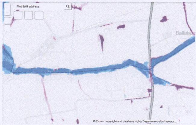
Alongside the site but separated from our proposed development site by two intervening hedges, is a stream and noted on the Indicative Flood Maps relating to Surface Water and Flood Risk from the stream, it suggests that there is little or no risk in our particular location from surface water flood risk but a medium risk if flooding were to occur from the stream.
A copy of the Indicative Flood Map is attached at APPENDIX 1.
The proposal seeks to gain planning approval for the erection of an extension to the rear of the existing stable block, tack room and storage barn building. The extension would take the form of a lean-to structure abutting the existing building and constructed in a similar timber frame to the existing with external shiplap timber boarding and a corrugated sheet roof over the lean-to area to match the existing building in all respects. The building would be used for machinery and implements used in connection with the upkeep of existing timber buildings and regular mowing of the adjacent paddock and meadows as noted on the planning application form.
A new concrete floor would be laid throughout the proposed extension and this would be set at the same level as the existing concrete floor within the stable block to give reasonable level access on the adjacent land. There would be a step up from the surrounding land but a temporary metal ramp would be utilised (as is the case for the storage barn) when any vehicles would be driven in or out of the proposed extension.
The use of the extension would be for storage purposes only with no-one occupying or working from the proposed extension.
It is not proposed to install any fixtures, fittings or electricity within the proposed building and this has been noted on the planning application form. Should any electric lighting need to be installed, it would be run at high level through the existing barn, along the timber roof structure and would be set along the timber roof rails underneath the roof sheeting. If lighting was installed and a separate switch system needed, the power to a switch would also run from the existing barn in ducting at high level and would run down the wall in a location in the vicinity of the open sided access area to the abutting paddock. Then any light switching would be set some 1.200-1.500 metres above the concrete floor level.
The Indicative Flood Map shows that the suggested level of flooding from the adjacent stream takes a diagonal line through the site almost cutting the building in half. It seems to indicate that the open end of our proposed building to provide access is outside the risk area.
Our client proposes to install a new concrete floor at the same level as the existing building and the gable wall facing the stream is solid with no window or door openings included.
The existing building has been in situ for some 13 years and has not suffered from any flooding issues, the proposed extension would be a welcome addition to the existing building to provide a large, dry under-cover storage area for machinery and implements which would otherwise be left outside to deteriorate or stored elsewhere off site and brought to the property when required. The location is in a sheltered section of the site surrounded by mature hedging and cannot be seen from any public location. It is not envisaged that the building will be used for anything other than the use described and there will not be a full electrical installation included with sockets and low level power units. As suggested, if lighting is included, it will run from the abutting barn and be set at roof level with a single switch system running down the wall surface to a point between 1.200 metres and 1.500 metres above floor level.
Should there ever be flooding from the adjacent stream, there would be no loss of fixtures, fittings or the like as the proposed extension seeks approval for a storage building only.
Flood National
Flood Attenuation Areas Designated Attenuation Extents Flood Risk - Initial High Likelihood Total Flood Delay (High Risk) Flood Risk - Initial Medium Likelihood Total Flood Delay (Medium Risk) Flood Risk - Initial Low Likelihood Total Flood Delay (Low Risk) Flood Risk - Fluent High Likelihood Fluent Flood Delay (High Risk) Flood Risk - Fluent Medium Likelihood Fluent Flood Delay (Medium Risk) Flood Risk - Fluent Low Likelihood Fluent Flood Delay (Low Risk) Flood Risk - Surface Water Surface Water High Likelihood Surface Water Medium Likelihood Surface Water Low Likelihood
The Department of Infrastructure has developed about nine indicators flood maps for surface water at closed sources.
Surface water led to flooding from bipress sandals, surface water flooding per happen index from a river and is what is looking for at with activities like urban drainage system and the proper water service for breakfast. Flooding on roads can be referred to as surface water flooding.
The following source from form-moment:
Then do not show the level of risk to individual properties.
National Flood Maps used in Planning
These maps provide an indication of flood risk from the sea. Although they give a good indication of the areas of land at risk of flooding, they do not provide detail of the risk to individual properties.
Flood risk areas are areas around the Island which could be affected in the event of flooding from the sea. None of the Island at risk of flooding from there are suspected risk if categories are not below:
National Flood Maps used in Planning
These maps provide an indication of flood risk from the sea. Although they give a good indication of the areas of land at risk of flooding, they do not provide detail of the risk to individual properties.
Flood risk areas are areas around the Island which could be affected in the event of flooding from the sea. None of the Island at risk of flooding from the sea are expected risk if categories are not below:
Nielsen - Maps underlined 1925
Please note the flood map only shows the available likelihood of flooding from water at the sea for defined areas and is not sufficiently selected to account for individual differences. Individual properties may therefore vary based on all the terms and conditions on each other. The following information is available for the information provided in particular property law: a different mix of flooding to that location on the flood map and/or if the water distribution has natural use may not meet claim into account when preparing the flood map please contact us.
Climate change is likely to increase extreme rainfall events and increase the size of our land has. Climate change allowances are included in the river and sea flood risk maps to make sufficient time per assessment of flood risk across the island, ensure future development is reasonable and minimal feedback are no make.
Climate change allowances is applied to the river and sea flood maps in this study. Four flood maps which proposed increase in river flows, based on proposed increase in annual precipitation, to the right (usually over-practice per river flood mapping places) at an increase in each floor estimate. While flood risk from the sea mapping, climate predicted increases in major sea zones, less flood maps also in pop. and at peak the climate change allowances applied may vary. Some who only the medium flood area displayed for floors and/or sea and the medium increase in flood maps may have a 20% (2001/2002) flood map. The need for a 20% (2001/2002) flood map may be limited to a 10% (1000/2001) sea areas to account for climate change. The more information on specific areas please contact us.
Weigh flood distances (working log) indicated on the flood map, given that they do not completely remove the risk of flooding and can be measured or fail in extreme weather conditions the flood maps do not carry this amount of land maximum annual fire (fired step and) difference (A place view or in the future) may have on the risk of flooding.
As and when additional natural information becomes available to us the flood map will be improved and updated.
Copyright in submitted documents remains with their authors. Request removal