Planning Statement For Extensions To The Dwelling And Replacement Of Existing Shed With Car Port, Duxbury House, Wigan Lane Ballamodha, Foxdale Road, Malew
1.0 INTRODUCTION
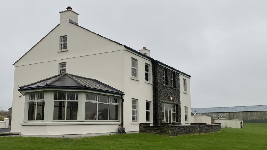
1.1 Kingsley Farm now called Duxbury House - sits alongside Wigan Lane and is a two storey relatively new house built in the late 2000s. This sits in approximately 0.5ha but within a wider area which includes land and buildings to the east. The house has a detached outbuilding to the rear (north) of the house which was in situ prior to the construction of the current dwelling which was a replacement for an earlier property on the site (06/00499/B, 07/00753/B, 08/00650/B and 09/00382/B - the last of which was implemented).
A photograph of a white two-story detached house featuring a stone-clad section and a large bay window, set in a grassy rural area with a long agricultural building in the background.
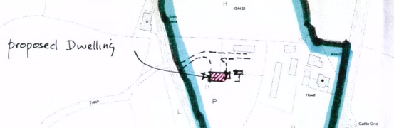
1.2 The original house, Howth, which was replaced originally sat alongside the A3 and is visible in this drawing from the 2008 application:
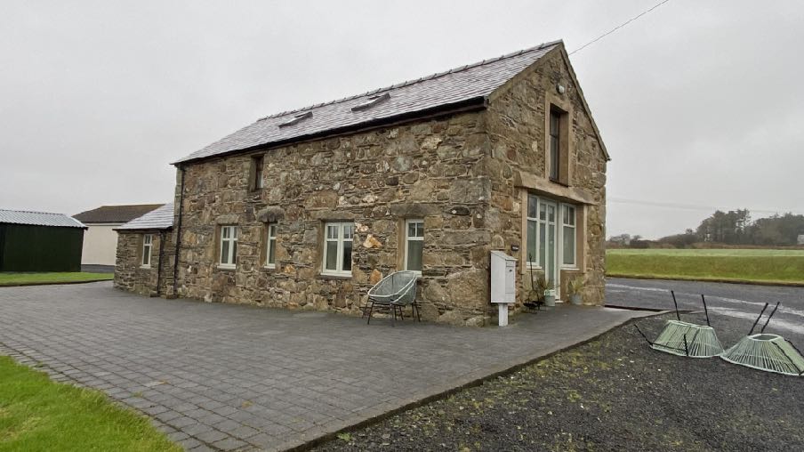
1.3 The applicant also owns land to the north, east and south. The land to the north and south constitutes open fields. The land to the east accommodates a second group of buildings, closer to and accessed from the A3. The dwelling on that site, Kingsley Cottage, was formed through the conversion of a former barn (04/00530/B and 04/02078/B) to a self contained dwelling.
A hand-drawn sketch plan overlaid on a faint map showing the location of a proposed dwelling and associated structures.
1.4 Following the approval of the conversion of the barn to a dwelling, a further applicationproposed a link which extended the converted barn accommodation into an adjacent former
A photograph of a detached stone building with a slate roof and paved driveway, situated in a rural setting with a green outbuilding to the side.
chicken shed which was to be converted to additional living accommodation (09/01857/B). This was refused as the building to be converted was not considered to be of historic, architectural or social interest and the original approval of the barn conversion was subject to a policy which presumed against the further extension of the property (Housing Policy 11).
1.5 Planning approval was granted for the re-roofing, replacement of windows and doors and rendering and painting of existing brickwork of existing outbuildings under 08/00648/B.
1.6 Permission was granted for the additional use of Kingsley Cottage as tourist accommodation under 22/01185/C.
1.7 The most recent applications on the site were 24/91103/B concerning the area around Kingsley Cottage - replacement of chicken shed with two tourist pods - permitted and conversion of the existing detached garage to a tourist unit - 24/91102/B - both permitted.
1.8 The application for the garage conversion was approved subject to a condition which suspends the provisions of the permitted development order in respect of the erection of a
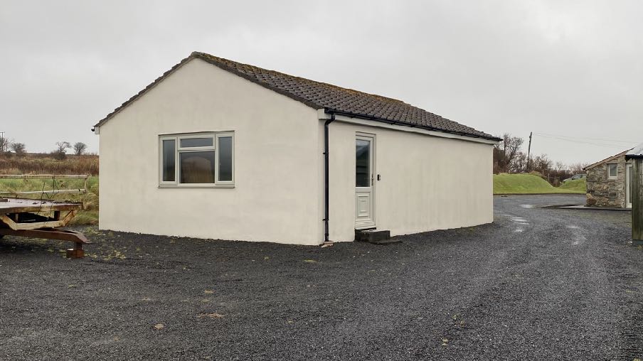
A photograph of a white, single-storey building with a tiled roof and gravel driveway in a rural setting.
further garage or car port, the extension of the dwelling house, any fences, walls or gates and any garden sheds or summer houses.
1.9 None of the approvals for the two dwellings, applies any occupancy condition (Kingsley Cottage has permission for use either as tourist accommodation or private residential) and the two groups of buildings are not linked through any planning condition.
2.0 PLANNING POLICY
Area Plan for the South
2.1 The starting point for the determination of any development proposal is the land use designation on the adopted development plan. In this case, that plan is the Area Plan for the South which was adopted in 2013.
2.2 On this plan, the site is located within an area not designated for a particular purpose which means it is considered to be countryside.
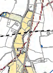
2.3 There is a Constraints map within the Area Plan bundle which shows the various potential constraints on development. In this case some of the site is shown as being of ecological importance (draft) with the footprint of the house and adjacent buildings appearing to be excluded.
2.4 There are no such areas shown on the Island Environment map (below) which shows Designated Wildlife Sites, Manx Wildlife Trust Nature Reserves, Areas of Special Protection,
A site plan or location map showing property boundaries, roads, and building footprints with yellow shading indicating specific zones.
Bird Sanctuaries, RAMSAR sites, National Nature Reserves and Areas of Special Scientific Interest.
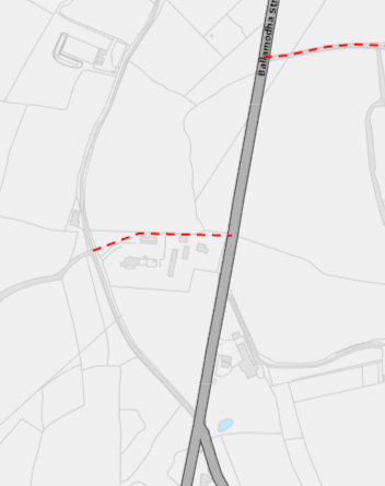
2.5 The red dotted line on the map above denotes the route of a public right of way (P205).
A site location map displaying a property boundary marked by a red dashed line next to Ballacrye St.
2.6 The Area Plan adopts the findings of the Government’s Landscape Character Assessment of 2008. It summarises the conclusions of that report and the full text is set out in Appendix One of this document. The summary in the Area Plan is as follows:
The overall strategy is to conserve and enhance the character, quality and distinctiveness of the area, with its wooded valley bottoms, its strong geometric field pattern delineated by Manx hedges, its numerous traditional buildings and its network of small roads and lanes. The strategy should also include the restoration of landscapes disturbed by former mining activities.
Key Views
Distant views prevented at times by dense woodland in river valleys and by the cumulative screening effect of hedgerow trees, which tend to create wooded horizons.
Open and panoramic views out to sea from the higher areas on the upper western parts of the area where there are few trees to interrupt views.
2.7 Further advice is provided at 3.23 to require that development achieves:
iii. Protection of the tranquil, rural character of the area with its open views.
iv. Sensitive location of new buildings and the use of screen planting.
v. Avoidance of physical or visual amalgamation of roadside housing.
Isle of Man Strategic Plan
2.8 The Strategic Plan, adopted in 2016 sets out generally non geographic policies which are applicable to development throughout the Island.
2.9 There is a presumption against further development in such areas unless it complies with the exceptions listed at General Policy 3: General Policy 3: Development will not be permitted outside of those areas which are zoned for development on the appropriate Area Plan with the exception of:
(a) essential housing for agricultural workers who have to live close to theirplace of work; (Housing Policies 7, 8, 9 and 10);
(b) conversion of redundant rural buildings which are of architectural, historic, or social value and interest; (Housing Policy 11);
(c) previously developed land(1) which contains a significant amount of building; where the continued use is redundant; where redevelopment would reduce the impact of the current situation on the landscape or the wider environment; and where the development proposed would result in improvements to the landscape or wider environment;
(d) the replacement of existing rural dwellings; (Housing Policies 12, 13 and 14);
(e) location-dependent development in connection with the working of minerals or the provision of necessary services;
(f) building and engineering operations which are essential for the conduct of agriculture or forestry;
(g) development recognised to be of overriding national need in land use planning terms and for which there is no reasonable and acceptable alternative; and
(h) buildings or works required for interpretation of the countryside, its wildlife or heritage.
2.10 In addition to these exceptions, there are also policies which allow for the extension of existing houses (Housing Policies 15 and 16):
Housing Policy 15: The extension or alteration of existing traditionally styled properties in the countryside will normally only be approved where these respect the proportion, form and appearance of the existing property. Only exceptionally will permission be granted for extensions which measure more than 50% of the existing building in terms of floor space (measured externally).
Housing Policy 16: The extension of non-traditional dwellings or those of poor or inappropriate form will not generally be permitted where this would increase the impact of the building as viewed by the public.
2.11 The Strategic Plan also has a suite of policies which protect certain aspects of the environment: development which is considered to be damaging to ecology is presumed against (Environment Policy 4), development which results int he loss of trees of amenity value is discouraged (Environment Policy 3) and development which results in the loss of high quality agricultural land is also presumed against (Environment Policy 14). In this case the soil is class 3/4 so not within the protected classes of land in this respect.
2.12 The site is not shown as being at risk of any flooding on the Flood Risk maps and is not within a Conservation Area nor contains any Registered Buildings or Registered Trees.
2.13 High voltage power cables cross the site. Development is expected to be at least 9m from such routes (Energy Policy 2).
2.14 The first land use plan for the Island was adopted in 1982 and included areas of an area of High Landscape or Coastal Value and Scenic Significance. The site is not within such an area. As such, Environment Policy 2 of the Strategic Plan is not considered relevant.
3.0 PROPOSED DEVELOPMENT
3.1 Proposed is a scheme of extension of the existing dwelling together with the erection of a car port in place of an existing shed which is to be demolished.
Extension to the dwelling
3.2 It is proposed to extend the dwelling, Duxbury House, to provide a pool and orangery including the demolition of the existing conservatory on the western gable. The front elevation faces north and currently has a solid walled extension on the eastern side and the conservatory on the western side, both of which were part of the originally approved replacement dwelling. The property has not been extended since then. The eastern annex is 4m wide and 8.2m long, stopping just short of the rear elevation facade. The conservatory on the western elevation sits towards the southern end of this elevation and projects out by
4.8m.
3.3 The proposed extensions aim to provide more balance to the property and to provide a swimming pool and associated facilities. The new western side extension will project out by 6.9m and the new extension to the rear of the existing eastern side extension projects out by the same amount. The two extensions either side of the rear elevation will be very similar in form and finish although that to the west, accommodating the pool, will have a greater length - extending to 13m past the rear facade whereas the eastern extension is only 4.4m past the rear.
3.4 The western elevation will be closest to Wigan Lane although is generally screened from view by the existing roadside hedges and established vegetation. As there is a public right of way running through the site, this extension will be visible but only at an angle from the north. This elevation will be mostly finished in painted render but with two stone sections to add interest and relief.
3.5 The existing floor area measured externally is 398 sq m over three floors. The proposed floor area is 583 sq m representing an increase of 46.5%.
Replacement of the existing outbuilding with a triple garage
3.5 It is proposed to replace the existing outbuilding to the north of the principal residence with a car port.
3.6 Planning approval is currently not required for the demolition of a detached building. There is Permitted Development for residential development including the erection of a car port or garage where this is no larger than 6.8m by 6.8m, 2.9m to the eaves and no higher than 4m. The shed which is to be replaced has a footprint of 20m by 6m.
3.7 The proposed car port will be 13.7m long and 6m front to rear, 2.25m to the eaves and
4.56m to the ridge. It is to be clad in timber on the sides and rear with an open frontage other than the eastern section which will feature a garage door. The existing building which it will replace is larger, at 19.5m by 5.7m, 3m to the eaves and 4.2m to the ridge.
3.8 The proposed pool will be drained into its own dedicated soakaway system with no pool water allowed to enter the foul drainage system - the biodisc treatment tank and reed bed. Details of this are provided separately by Preston Pools and confirms that emptying the pool is a rare occurrence, perhaps if there were glass contamination and that minor contamination can be dealt with through targeted clearing, filtration and appropriate chemical treatment rather than full emptying.
3.9 The proposed extension will be located on an area of ground which is presently domestic lawn.
4.0 ASSESSMENT
4.1 The Strategic Plan first and foremost protects the environment from harm and the countryside from development which would adversely affect it (Environment Policy 1). Whilst General Policy 3 sets out exceptions to the presumption against development in the countryside, it does not include extensions to existing residential property. Nevertheless, it is clearly acceptable to extend existing residential properties as Housing Policies 15 and 16 allow this.
4.2 The policies deal with houses which are either traditional or which are not and/or of poor form. In this case the house does not strictly adhere to the design guidance and proportions advocated in the Planning Circular 3/91 - Guide to the Design of Residential Development in the Countryside. However, it is traditionally styled, with simple rectangular form and layout, chimneys on each gable and vertically proportioned windows. The front, northern elevation has a central two storey stone front central projection and the rear has a central stone section and patio doors at ground floor level.
4.3 For the purposes of the housing policies which guide extensions, it is assumed that the existing house will be considered to be traditional and as such, Housing Policy 15 is the appropriate policy to apply.
4.4 This requires that extensions respect the proportion, form and appearance of the existing property and are generally no greater than 50% of the existing floor area. In this case, the extensions are less than 50% and restricted to single storey, replacing an existing conservatory on the western elevation. The two storey original section is maintained as the principal element and more symmetry is achieved in the overall building mass. The use of stone also minimises the impact of the new extensions and distinguishes them from the principal core section.
4.5 Whilst the swimming pool extension is longer than any existing element, its single storey nature reduces its impact which in any case, is negligible due to the existing roadside hedging and vegetation and whilst there is a footpath which crosses the site, this is to the north of the proposed extension and from where the full length will not be appreciable. From the south, the length of this extension will be less obvious and what will be seen, particularly from a distance, are two new stone symmetrical extensions either side of the principal core.
4.6 The materials match those on the existing building and the proportions, roof pitches and character, we would say, complement what exists moreso than does the existing conservatory.
4.7 The existing sheeted agricultural building to the rear of the house is visible from Wigan Lane and is somewhat out of keeping with its context which is a residential curtilage and surrounded by domestic style walling and close to the existing principal dwelling. The proposed car port with its timber cladding will have a more positive visual impact on the landscape and the setting of the residential buildings around it.
4.8 Whilst part of the site is shown as being of ecological interest, the area of the proposed development is improved domestic lawn and therefore considered not to represent a significant or unacceptable loss of any ecological habitat.
5.0 Conclusion
5.1 There are policies which support the extension of existing dwellings in the countryside. The history of the current dwelling is that it replaced a dwelling formerly on the site but the new dwelling was relocated further from the highway. The intention was for the house to be traditional and indeed it incorporates some traditional features - substantial chimneys, a rectangular mass and footprint and vertically proportioned windows but is undoubtedly larger than the traditional modest Manx cottage. It also sits in a relatively formal setting.
5.2 The dwelling would not appear to have been extended since its initial construction which included both single storey side extensions, so the property benefits from the the Town and Country Planning (Permitted Development) Order 2012 in respect of further extensions (currently up to 35 sq m). There was also no condition on the original approval which suspends the provisions of the Permitted Development Order in any respect so amongst other things, the existing windows could be replaced without permission provided that the openings are not being changed and additional sheds and greenhouses and other domestic structures could be erected within the residential curtilage.
5.3 The policy on the further extension of the dwelling is Housing Policy 15. This allows for the extension or alteration of existing traditionally styled properties in the countryside where this respects the proportion, form and appearance of the existing property. Only exceptionally will permission be granted for extensions which measure more than 50% of
the existing building in terms of floor space (measured externally). The proposed extensions amount to an increase of 46.5% and thus fall within the parameters allowed by the policy.
5.4 The proposed works we feel will sit comfortably in their context and have an acceptable impact on the landscape and will generally be well screened from public view with only those using the public footpath having a view of the proposed extensions and even then, they are unlikely to see any of the easternmost extension and the view of the western swimming pool extension will be at an angle so that it will not be seen in its fullest extent.
5.5 The proposed car port will be a smaller and more attractive and more appropriate building within this residential curtilage and will have a positive impact on the landscape.
5.6 The proposed swimming pool will have an appropriate means of drainage such that there will be no adverse impact on the environment from it or its maintenance.
5.7 We would submit that the proposals comply with the policies which aim to protect the countryside and will result in an acceptable form of development which has no harmful impact on the landscape or those within it.
Sarah Corlett 15.08.25
APPENDIX ONE - excerpt from the Landscape Character Assessment 2008 D14 – BALLAMODHA AND ST MARK’S Key Characteristics
• Land slopes down from the southern uplands towards the coast.
• Numerous deeply incised wooded river valleys and glens cut down into the landscape forming ribbons of fragmented woodland.
• National Glens at Silverdale and Colby
• Settled farmland character with some large nucleated settlements along the A7, small villages and a variety of scattered dwellings and farms.
• Smaller predominantly rectangular pastoral fields with Manx hedges topped with gorse on the upland slopes to the north.
• Patches of gorse, bracken and heather in fields on the upper slopes.
• Larger rectilinear pastoral and arable fields with large deciduous trees growing on Manx hedges on the more gently sloping southern slopes.
• Around the various settlements and farms there are smaller rectangular arable and pastoral fields with Manx hedgerows containing numerous trees and some stone walls.
• Network of tracks, small lanes and larger roads enclosed by substantial hedgerows containing deciduous trees all growing on grass covered Manx hedges.
• Numerous small reservoirs and water bodies associated with water courses.
• Some small churches with spires as well as various standing stones and other visible archaeological sites.
• Presence of Manx Milestones.
• Quarries at Turkeyland and at Ballown.
Overall Character Description Land slopes steeply down from the southern uplands with small rectangular fields of rough pasture containing patches of gorse and some bracken in places where these upland species have spread out from the low Manx hedges. A variety of predominantly stone hill farms with numerous outhouses surrounded by fragmented woodland, such as Ballaglashan and Glenmoar Farm, are located on these steeper slopes. The tight geometric field pattern on these slopes loosens as the slope angle becomes shallower with larger, predominantly angular but irregularly shaped fields of grazing and agriculture covering the majority of the flatter southern area. Smaller fields surround the various small clustered settlements. There are also groups of trees surrounding these settlements (e.g. the more traditional village of
St. Mark’s with its stone houses, church and conservation area) and also around loosely clustered dwellings such as those along the A34 north of Ballasalla. Located along the busy A7 road are the two larger nucleated settlements of Ballabeg and Colby whose traditional fabric has been added to with numerous modern extensions that back onto small fields with some screening in the form of mature trees in surrounding hedgerows.
Through this gently sloping and undulating landscape cut numerous steep sided deep and heavily vegetated river valleys, including Colby River, Silver Burn and Santon Burn, with numerous smaller tributaries joining their courses along with various rectilinear drainage ditches. These wooded valleys form sinuous fingers of fragmented woodland that cut across and disrupt the field pattern and otherwise gently sloping landform. Colby Glen and Siverdale Glen are designated both as conservation areas and National Glens. These glens were developed during the Victorian times to allow visitors waterside access and a chance to experience these enclosed valleys and their lush riparian vegetation by way of footbridges and paths with handrails to promenade. Many original features remain today.
A network of small tracks, narrow roads and larger A roads traverse the area and are predominantly contained by steep sided grassy banks of the Manx hedgerows that line the roads, with varying hedgerows, some containing trees in places. There is a settled but semirural character. There is a relatively strong sense of tranquillity that pervades much of the area. Wooded horizons are common inmost places, creating an intimate contained and continuous character. The steep sided Glens break what would otherwise be a relatively monotonous landscape to create active and dramatic elements that one can descend down into from the surrounding fields.
Key Views
• Distant views prevented at times by dense woodland in river valleys and by the cumulative screening effect of hedgerow trees, which tend to create wooded horizons.
• Open and panoramic views out to sea from the higher areas on the upper western parts of the area where there are few trees to interrupt views.
Historic Features
• Numerous chapels and churches including Columbus Church and Kirk Santon with Medieval crosses
• Standing stones and some earthworks
• Rushen Abbey (Cistercian) and Monks Bridge
• Silverdale watermill and roundabout
Ecological Features
• Farmland grassland habitats
• Mature network of hedgerows containing deciduous trees in field boundaries
• Aquatic and waterside habitats along river courses
• Dense riparian woodland in Glen bottoms
• Fragmented blocks of deciduous woodland
• Bird sanctuary at junction of A34 and A3
Evaluation of Inherent Landscape Sensitivities
• Mixture of field size and pattern with various hedges containing a variety of vegetation.
• Fragmented woodland in valley bottoms and along National Glens.
• Rivers and reservoirs with aquatic ecosystem with riparian habitats.
• Built up edge of Ballasalla and nucleated settlements of Ballabeg and Colby.
• Scattered traditional farms and hamlets fringed by deciduous woodland.
• Network of tracks, small lanes and larger roads enclosed by substantial hedgerows containing deciduous trees all growing on grass covered Manx hedges.
• Sites of archaeological importance.
• Manx Milestones by roadside.
• Victorian Isle of Man Steam Railway station and halts.
Landscape Strategy The overall strategy for the area should be to conserve and enhance the character, quality and distinctiveness of this farmed landscape with various field patterns defined by different hedges, a scattered settlement pattern of traditional hamlets, farmsteads and nucleated settlements fringed by trees, a varied road network enclosed by grassed Manx hedges and roadside vegetation, and numerous wooded valleys and glens. In addition to the conservation of archaeological sites, measures should also be adopted to conserve and enhance the physical structure and setting of upstanding heritage features such as the Silverdale watermill.
Copyright in submitted documents remains with their authors. Request removal
Source & Provenance
Official reference
25/90795/B
Source authority
Isle of Man Government Planning & Building Control