Planning Statement In Support Of Alterations And Extensions, Wits End, Dandy Hill, Port Erin Im9 6Hn
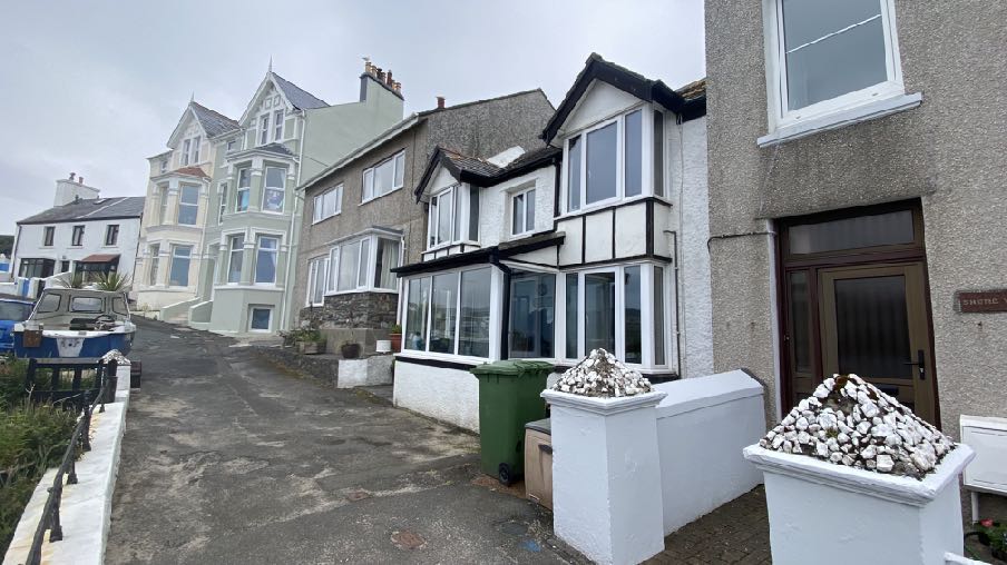
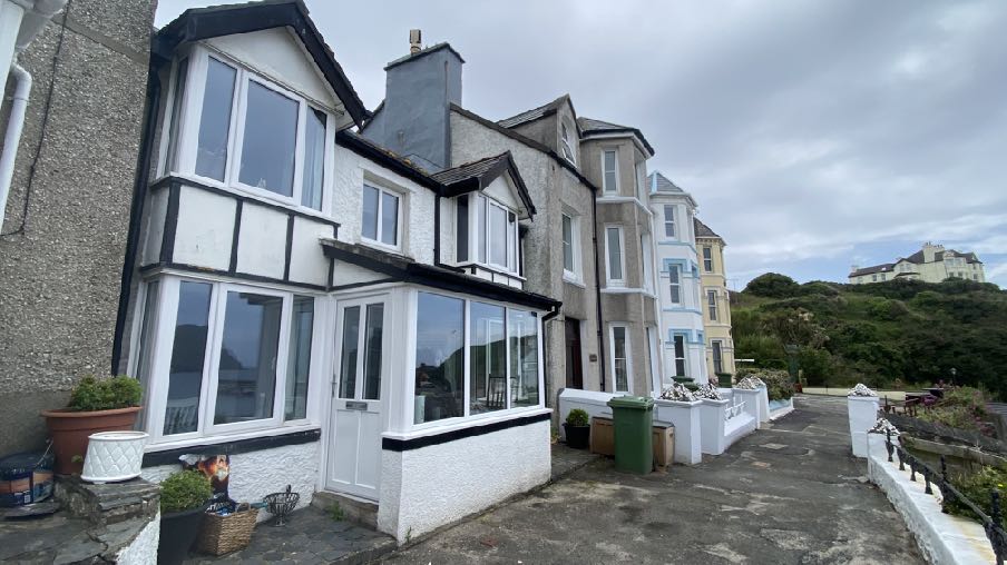
A street-level photograph showing a row of residential properties in a coastal village, featuring a house with a black and white timber facade and a large conservatory extension.
1.0 INTRODUCTION
1.1 Wits End is an existing mid terraced property which sits facing north west within the short cul de sac of Dandy Hill.
1.2 The dwelling looks out over Port Erin Bay with small, detached gardens lying immediately opposite the property and sloping grassed brooghs lying further to the north with public footpaths criss crossing them. The existing shelters lie at the base of the brooghs with the promenade passing in front and separating them from the sandy beach.
1.3 An existing modern bungalow - Sea Breeze - lies below the detached gardens with its ridge sitting just a little higher than the Dandy Hill roadway.
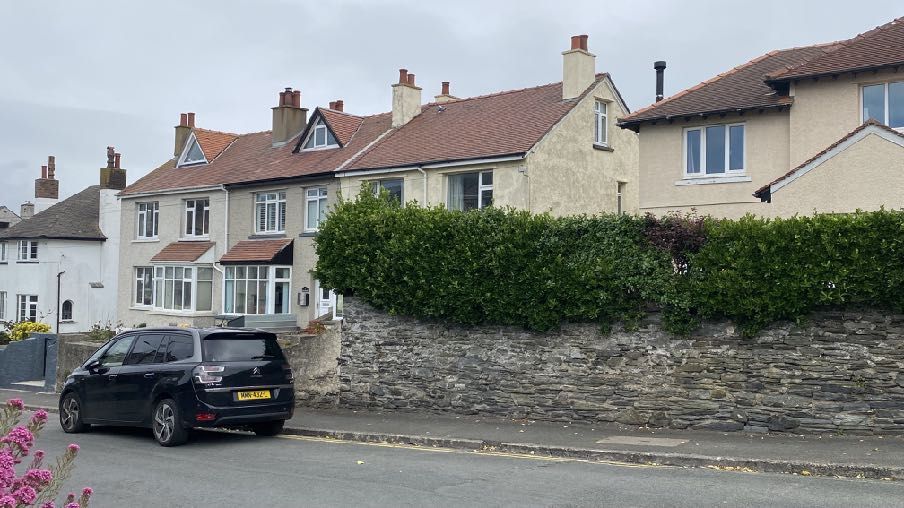
1.4 Dandy Hill comprises a mix of dwelling types with a variety of heights, finished and ages of property. Towards each end are three storey bay windowed properties with vertically oriented windows and a range of render finishes, some with their original mouldings and string courses and all with pitched, slated roofs. In between these two three storey elements are Wits End and Fisherman’s Cottage.
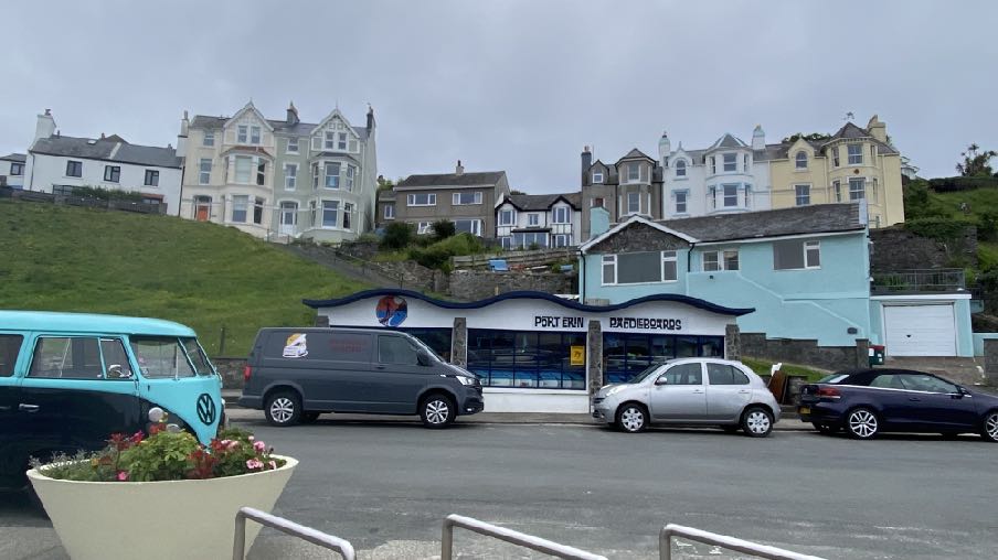
A street-level photograph showing a parking area with vehicles in front of a shop, with a grassy hill and large residential houses in the background.
1.5 Wits End is the smallest property in the terrace with a projecting ground floor porch, projecting pitched roofed bays set back from and above the porch and a pitched, slated roof above. At the rear is a further projection with a decked area providing a rear garden at the higher level. The property has no on site parking and the front of the porch is flush with the highway.
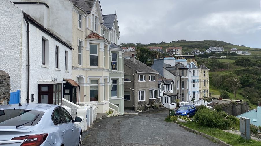
A street-level photograph showing a row of residential houses on a hillside in a coastal town, with a car parked in the foreground.Street-level photograph of a white and black timber-framed terraced house with a large bay window and porch, situated in a row of similar buildings.
1.6 Fisherman’s Cottage is the most modern of the properties in the road with two storeys of accommodation in a relatively simple, dashed rectangular building with a slightly curved bay window and a square projecting bay window both at ground floor level with horizontally proportioned windows above. There is a two storey extension to the north east, slightly set back from the principal elevation and at the ground floor there are garage doors. Like Wits End, the property has uPVC framed windows throughout.
1.7 Dandy Hill is a few minutes’ walk from the village centre and the beach and within convenient walking distance of the network of public footpaths, large areas of public open space and glens and various recreation facilities such as the bowling green.
2.0 PLANNING POLICY
Area Plan for the South (2013)
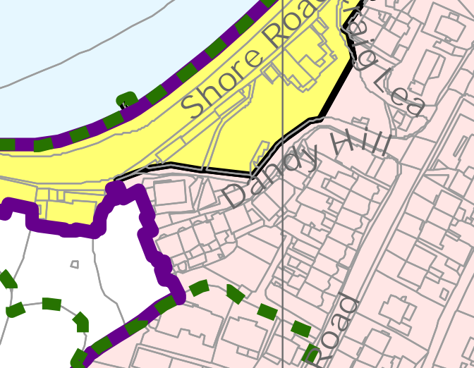
2.1 The site lies within an area designated on the adopted development plan, the Area Plan for the South, as Predominantly Residential (pink) with the brooghs and promenade shown as Mixed Use:
2.2 The green dotted line denotes the boundary of a proposed Conservation Area (see later). The site lies within this.
2.3 The purple line delineates the settlement boundary within which the application site sits.
2.4 There is a Constraints Map which accompanies the development plan. The only Constraint shown applying to the site is the proposed Conservation Area (see above).
2.5 There are no Registered Trees or Registered Buildings on or near the site.
A site location map showing the property boundaries highlighted in yellow and purple along Shore Road and Dandy Hill.
Isle of Man Strategic Plan (2016)
2.6 In terms of overarching strategic policy, the following policies are considered to be relevant to this proposed development:
Strategic Policy 1: Development should make the best use of resources by:
(a) optimising the use of previously developed land, redundant buildings, unused and underused land and buildings, and reusing scarce indigenous building materials;
(b) ensuring efficient use of sites, taking into account the needs for access, landscaping, open space(1) and amenity standards; and
(c) being located so as to utilise existing and planned infrastructure, facilities and services.
Strategic Policy 2: New development will be located primarily within our existing towns and villages, or, where appropriate, in sustainable urban extensions of these towns and villages. Development will be permitted in the countryside only in the exceptional circumstances identified in paragraph 6.3.
Strategic Policy 3: Proposals for development must ensure that the individual character of our towns and villages is protected or enhanced by:
(a) avoiding coalescence and maintaining adequate physical separation between settlements; and
(b) having regard in the design of new development to the use of local materials and character.
Strategic Policy 4: Proposals for development must:
(a) Protect or enhance the fabric and setting of Ancient Monuments, Registered Buildings, Conservation Areas, buildings and structures within National Heritage Areas and sites of archaeological interest;
(b) protect or enhance the landscape quality and nature conservation value of urban as well as rural areas but especially in respect to development adjacent to Areas of Special Scientific Interest and other designations; and
(c) not cause or lead to unacceptable environmental pollution or disturbance.
Strategic Policy 5: New development, including individual buildings, should be designed so as to make a positive contribution to the environment of the Island. In appropriate cases the Department will require planning applications to be supported by a Design Statement which will be required to take account of the Strategic Aim and Policies.
Strategic Policy 10: New development should be located and designed such as to promote a more integrated transport network with the aim to:
(a) minimise journeys, especially by private car;
(b) make best use of public transport;
(c) not adversely affect highway safety for all users, and
(d) encourage pedestrian movement,
Strategic Policy 12: Favourable consideration will generally be given to proposals for improving the quality and condition of the existing housing stock and for the creation of flats by conversion of redundant boarding houses, and vacant or under-used space above commercial premises subject to compliance with detailed standards (see section 8.13).
Spatial Policy 2: Outside Douglas development will be concentrated on the following Service Centres to provide regeneration and choice of location for housing, employment and services - Ramsey, Peel, Port Erin, Castletown, Onchan. Area Plans will define the development boundaries of such centres so as to provide a range of housing and employment opportunities at a scale appropriate to the settlement.
Spatial Policy 5: New development will be located within the defined settlements. Development will only be permitted in the countryside in accordance with General Policy 3.
General Policy 2: Development which is in accordance with the land-use zoning and proposals in the appropriate Area Plan and with other policies of this Strategic Plan will normally be permitted, provided that the development:
(a) is in accordance with the design brief in the Area Plan where there is such a brief;
(b) respects the site and surroundings in terms of the siting, layout, scale, form, design and landscaping of buildings and the spaces around them;
(c) does not affect adversely the character of the surrounding landscape or townscape;
(d) does not adversely affect the protected wildlife or locally important habitats on the site or adjacent land, including water courses;
(e) does not affect adversely public views of the sea;
(f) incorporates where possible existing topography and landscape features, particularly trees and sod banks;
(g) does not affect adversely the amenity of local residents or the character of the locality;
(h) provides satisfactory amenity standards in itself, including where appropriate safe and convenient access for all highway users, together with adequate parking, servicing and manoeuvring space;
(i) does not have an unacceptable effect on road safety or traffic flows on the local highways;
(j) can be provided with all necessary services;
(k) does not prejudice the use or development of adjoining land in accordance with the appropriate Area Plan;
(l) is not on contaminated land or subject to unreasonable risk of erosion or flooding;
(m) takes account of community and personal safety and security in the design of buildings and the spaces around them; and
(n) is designed having due regard to best practice in reducing energy consumption.
Environment Policy 34: In the maintenance, alteration or extension of pre-1920 buildings, the use of traditional materials will be preferred.
Environment Policy 35: Within Conservation Areas, the Department will permit only development which would preserve or enhance the character or appearance of the Area, and will ensure that the special features contributing to the character and quality are protected against inappropriate development.
Environment Policy 39: The general presumption will be in favour of retaining buildings which make a positive contribution to the character or appearance of the Conservation Area.
Environment Policy 42: New development in existing settlements must be designed to take account of the particular character and identity, in terms of buildings and landscape features of the immediate locality. Inappropriate backland development, and the removal of open or green spaces which contribute to the visual amenity and sense of place of a particular area will not be permitted. Those open or green spaces which are to be preserved will be identified in Area Plans.
Housing Policy 6: Development of land which is zoned for residential development must be undertaken in accordance with the brief in the relevant area plan, or, in the absence of a brief, in accordance with the criteria in paragraph 6.2 of this Plan. Briefs will encourage good and innovative design, and will not be needlessly prescriptive.
Transport Policy 1: New development should, where possible, be located close to existing public transport facilities and routes, including pedestrian, cycle and rail routes.
Transport Policy 7: The Department will require that in all new development, parking provision must be in accordance with the Department’s current standards.
Residential Design Guide (2021)
2.7 This provides advice on the design and finish of residential development as well as guidance on how to assess the impact of new development on the living conditions of those in existing residential property.
2.8 Amongst other things, the Guide states the following:
“3.1.2 This document is intended to facilitate good quality design, and an important aspect of that is local distinctiveness.
3.1.3 New residential development should be informed by the best qualities of our existing residential areas. However, this does not mean that all new residential developments should seek to replicate the appearance of older ones, and good quality contemporary design is encouraged.
3.2.1 A residential development should avoid having the same type, height, and density throughout, including avoiding continuous, bland, and uninteresting roofscapes.
5.3.14 The Department recognises that in some instances contemporary design solutions may be appropriate, providing they are of a high standard of design quality, and are of appropriate form, scale, and materials. Examples of more modern finishes include large areas of frameless glazing forming the extension, the use of timber/ metal cladding, and a variety of roofing finishes, including sedum, copper, or aluminium.
2.9 Good design should not, as the Strategic Plan says, represent a “slavish following ofpast design idioms, evolved for earlier lifestyles can produce buildings which do notreflect twenty first century lifestyles including accessibility and energy conservation.While there is often a consensus about what constitutes good and poor design, it isnotoriously difficult to define or prescribe”.
Permitted Development
2.10 There is a range of permitted development available to the property including thereplacement of windows and the use of the property for taking in guests or as touristaccommodation.
Planning Policy Statement 1/01 - Conservation of the Historic Environment of the Isle of Man
2.11 Whilst the Conservation Area is not yet designated, it is relevant to look to the policyguidance on development within adopted Conservation Areas.
POLICY CA/2 SPECIAL PLANNING CONSIDERATIONS When considering proposals for the possible development of any land or buildings which fall within the conservation area, the impact of such proposals upon the special character of the area, will be a material consideration when assessing the application. Where a development is proposed for land which, although not within the boundaries of the conservation area, would affect its context or setting, or views into or out of the area; such issues should be given special consideration where the character or appearance of a conservation area may be affected.
Port Erin Conservation Area draft Character Appraisal 2009
2.12 Dandy Hill is referred to specifically in a number of places within this document which was prepared to inform and support the designation of a Conservation Area in Port Erin although such has not yet been adopted despite some significant time since its first proposal.
It is not however possible to determine how large the hamlet/village was, other than that it is likely to have had fewer buildings than were in existence in the late 1830s/ 1840s when guides stated that the village consisted of about ‘forty dwellings, a small Wesleyan chapel [(Actually a Primitive Methodist chapel) on Dandy Hill, opened in 1832, but demolished circa 1973], and a comfortable inn [White Lion in 1837, Queen’s Arms in 1843 and 1846 (the site was re-used for the building of the Falcon’s Nest Hotel in 1859/60 by R Cain]’ and in 1860 when there were ‘only thirty-five houses’.
The 1869 OS map shows the buildings in Port Erin located on the water’s edge along the Shore Road, on Strand Road and Dandy Hill (together with some houses in the former villages of Darrag, Strooansnail and at the north end of the Promenade near the entrance to Bradda Glen). It appears reasonable to assume that the earlier buildings in the village were also located in these same areas.
2.3.1. Character and interrelationship of spaces within the area The sea is an important feature in the conservation area, creating considerable interrelationships between spaces in the area. A number of roads follow the line of the seafront (the Promenade, Shore Road and Dandy Hill) and as such, there is a natural flow of movement around the bay, linking the buildings along the bay. The only constriction
to this is the point between the Promenade and Shore Road where there is a considerable change in level (and pedestrian access only).
2.4.5. Local details A distinctive Manx architectural feature occurring occasionally in the conservation area is relict evidence of the use of thatch. Primrose Cottage is the only building in Port Erin which is still thatched, however, the Cozy Nook Café on Shore Road, one of the houses on Dandy Hill and one of the cottages at the entrance to Bradda Glen all have indications that they may have been thatched in the past. The Cozy Nook Café and building on Dandy Hill both have weatherings on their chimney stacks (see photo below), while the cottage near the Bradda Glen has Bwid sugganes (these are small stones projecting from the exterior walls just under the roof line, used to hold ropes to tie down the thatch).
2.13 The potentially formerly thatched property referred to is not Wits End and is Baljean and The Cottage at the north eastern end of the cul de sac.
3.0 PLANNING HISTORY
3.1 The site has been the subject of two previous applications:
14/00674/B - installation of windows to front elevation - refused 14/01140/B - installation of replacement windows - permitted.
3.2 The replacement of windows, even within proposed Conservation Areas is now Permitted Development (Class 24).
3.3 Fisherman’s Cottage was the subject of an application permitted in 2021 for an extension and raised decking at the rear - 20/01342/B.
4.0 THE PROPOSAL
4.1 Proposed is the refurbishment of the property including an upward extension and the installation of dormer window creating more and more usable space in the upper part of the building. Alterations are also proposed to the fenestration and porch.
4.2 The works effectively create a third floor of accommodation within the roof by extending upward through a larger roof structure comprising a large dormer clad in natural slate and set back from the from the facade by approximately 350mm with the roof conturing in a mansard style further back than the front dormer window. The sides of the dormer will be finished in smooth cladding board.
4.3 The extension will raise the apex of the roof by 1.5m but will remain below the ridges of both adjoining properties.
4.4 At the rear the existing rear extension will be retained as is with the roof reconfigured to be a flat roofed dormer structure affording more internal space at this level. The rear will be finished, like the front, in natural slate with a flat roof which accommodates a single flat roof light serving the stairwell. A new door will be installed in the first floor at the rear to provide access to the existing upper deck and the second floor will feature one window in the rear elevation of the new extension, serving a bathroom.
4.5 The front elevation below the dormer will see the existing central first floor window enlarged in line with the height of the existing windows either side and a Juliet balcony created. The existing black and white panels between ground and first floor windows will be replaced with wood effect fibre cement weatherboard and windows and doors will be framed in black uPVC. The existing porch will be redesigned to have a flat roof still positioned centrally within the front elevation.
4.6 It is intended that the property will be used for tourist as well as permanent residential accommodation which does not require planning approval.
5.0 Assessment
A street-level photograph showing a row of terraced houses with pitched roofs and chimneys, separated from the road by a stone wall and hedge.
5.1 The works proposed would revitalise an existing, modest property which sits with a spectacular outlook across the bay. Currently there are limited opportunities within the building to maximise this outlook and solar gain. What is proposed aims to optimise this without creating a discordant or harmful impact on the streetscene.
5.2 The Conservation Area Character Appraisal does not identify the buildings within Dandy Hill (other than the older cottage at the north eastern end) and talks more about the alignment of the roadway and adjacent buildings. What is proposed will not change that. Also, the property will remain lower than its neighbours and with distinctive black and white colouring that it currently retains.
5.3 The properties on Dandy Hill are all very different from each other and form an interesting if inconsistent group overlooking the promenade and bay. The property itself is also a little inconsistent with no particular character and a mix of older and newer elements.
5.4 The proposal will provide a consistent finish and character throughout the building, front and rear whilst maintaining its modest proportions relative to its neighbours. The use of dark cladding will sit well with the black window and door frames and minimise the impact of the new roof and dormer and the vertical emphasis is retained, arguably enhanced through the design of the windows and doors.
5.5 The introduction of unusual dormers is not uncommon within the village with a number of properties featuring the distinctive triangular dormer seen here in Ballafurt Road:
5.6 Other, older properties also incorporate accommodation within the roof space served by turrets and towers with windows in three sides.
5.7 Darrag, to the south west of the site, includes a number of properties which have other, unusual dormers.
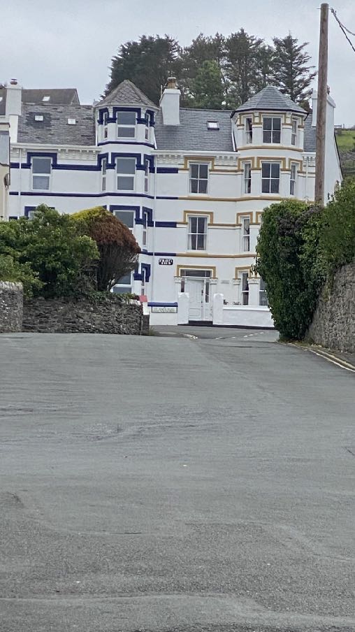
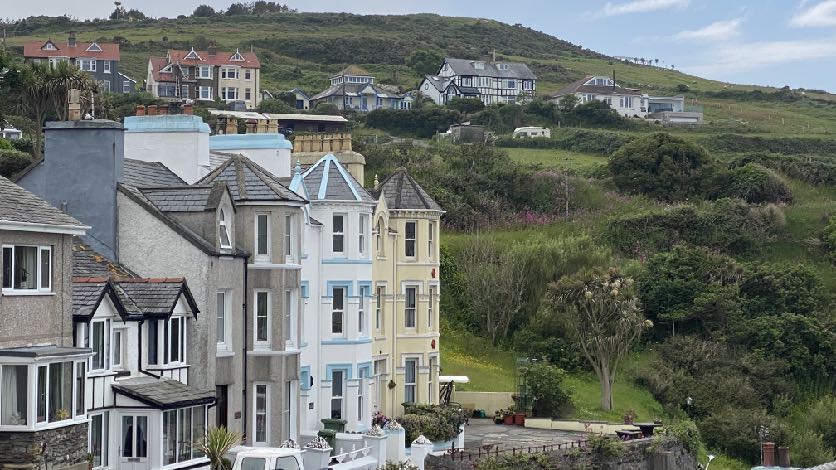
A photograph showing a large, white multi-story building with blue and gold trim situated on a hillside, viewed from a paved road.A photograph showing a row of terraced houses in the foreground with a grassy hillside and scattered residential properties in the background.
5.8 All these features add to the interest and character of the village and the buildings within it. As the Residential Design Guide and Strategic Plan suggest, The Department recognises that in some instances contemporary design solutions may be appropriate, providing they are of a high standard of design quality, and are of appropriate form, scale, and materials. Examples of more modern finishes include large areas of frameless glazing forming the extension, the use of timber/metal cladding, and a variety of roofing finishes, including sedum, copper, or aluminium. Good design should not, as the Strategic Plan says, represent a “slavish following of past design idioms, evolved for earlier lifestyles can produce buildings which do not reflect twenty first century lifestyles including accessibility and energy conservation.
5.9 It is also fully accepted that “While there is often a consensus about what constitutes good and poor design, it is notoriously difficult to define or prescribe”.
5.10 We would submit that what is proposed brings consistency within the building and will revitalise this property into a modern, comfortable property which takes full advantage of the outlook and opportunities for solar gain. The existing roof requires replacing and in so doing the opportunity is being taken to optimise the accommodation available. Whilst the design and character are unashamedly modern, what exists, we would suggest, brings little in the way of architectural, social or historical distinctiveness or interest and what is proposed will be attractive and will sit comfortably in this streetscene. The use of dark colouring in most of the new materials will reduce the impact of the proposed additions and enable the property to remain relatively unobtrusively in this context.
5.11 We are of the view that the proposal accords with all of the relevant planning policies referred to above, supporting sustainable development within a settlement and in a location which is within minutes walking distance of the village centre and a variety of transportation links. The design will add interest to the area without being discordant and will support local distinctiveness referred to in the Residential Design Guide. The only new window to be introduced at the rear will serve a bathroom.
5.12 Whilst the property lies within a proposed Conservation Area, that has not yet been adopted. What is proposed, nevertheless we feel will not prejudice any future such designation, this property being a very modest and insignificant element within a much wider area. The proposal will maintain the broad range of building styles, the use of materials and designs and whilst the proposal will not utilise traditional materials or design characteristics,
we would submit that what exists is not traditional or vernacular and as such, a traditional approach would not necessarily be appropriate here.
5.13 We hope that the proposal is considered to constitute good design with the use of good quality materials so that this modest property may be modernised and revitalised as shown in the submitted drawings.
Sarah Corlett 14.07.25
Copyright in submitted documents remains with their authors. Request removal
Source & Provenance
Official reference
25/90693/B
Source authority
Isle of Man Government Planning & Building Control