Planning Statement In Support Of The Installation Of A Mineral Washing Plant (Mwp) At Billown Quarry, Billown, Ballasalla Im9 3Dw
1.0 INTRODUCTION
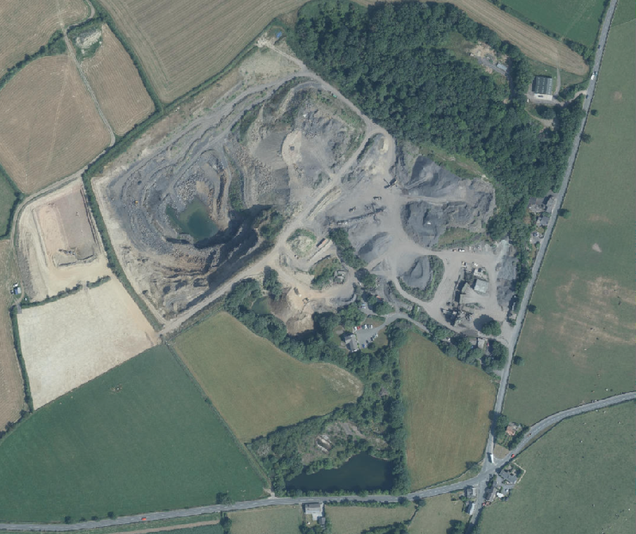
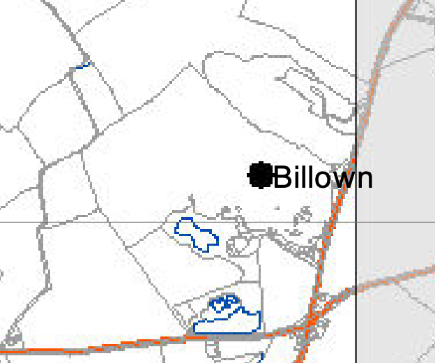
1.1 The site is the curtilage of Billown Quarry, a working limestone extraction and material processing site and asphalt production operation situated to the north of Cross Four Ways to the south west of Ballasalla.
1.2 The site also includes the office facilities of Manx Rock Limited (formerly Colas IOM Ltd) which are accommodated in Broom House, to the immediate south of the restored former workings as well as a reclaimed quarry pond to the west of Broom House.
1.3 Various applications have extended the range of the quarry both geographically and operationally (see Planning History). The site has also seen the restoration of the grassland in the former quarry pond alongside Broom House. Permission has been granted recently for the restoration of the worked quarry through the importation of inert waste.
1.4 To the north west of the asphalt plant are two dwellings - Nyn-Ayrn Cottage and Grassholme Cottage which are in separate ownership from the quarry.
1.5 Access to the quarry and asphalt plant is directly from the A3 Foxdale Road which runs to the east of the site. There are two vehicular accesses - one serving the quarry and the asphalt plant and the other serving Broom House but which also provides access to the quarry to the north west.
1.6 The land surrounding the quarry and asphalt plant is generally open, agricultural land with the original part of the quarry, Broom House and the asphalt plant surrounded by woodland.
1.7 To the south is a further area of woodland and a water body which is an Area of Special Scientific Interest (Rosehill Quarry).
2.0 PLANNING HISTORY
2.1 The following applications have been submitted in respect of this site:
22/00922/B - restoration of quarry by infill - permitted. The reason for the approval is that:
There is an evidenced need for the landfill facility at Billown Quarry in terms both of the priority for identifying disposal capacity for inert waste in the Government’s Waste Infrastructure Hierarchy as set out in the Waste Strategy, and the need to infill and restore the quarry to agricultural use as required by the earlier permissions. There is no realistic alternative. As confirmed in the Environmental Impact Assessment Report, the landfill operations would not give rise to any unacceptable environmental impacts, subject to appropriate conditions. Moreover, the option to work any new reserves at a later date (prior to completion of landfill) and/or from the surface if required, would remain. There would be no conflict, therefore, with the relevant policies of the Strategic Plan or the Waste Strategy.
22/00140/B - erection of a replacement dust shed - permitted 18/01193/B - infilling of quarry and restoration of grassland - permitted 18/00161/B - extension of existing quarry - permitted The Inspector considering this application notes the following:
“76 Minerals Policy 1 of the Isle of Man Strategic Plan states that development involving the winning and working of minerals will be permitted only where it is demonstrated that there is a need which cannot be met through the provision of secondary aggregates. The Wardell Armstrong report states that”the demand for the type of mineral products produced by Billown cannot be met through the provision of secondary aggregates.” I have seen no evidence which contradicts that assessment.
77 If the Poortown Quarry is excluded from the calculation, the Isle of Man’s consented reserve of hard rock with bitumen affinity, suitable for the production of asphalt, is likely to be exhausted within a few months. If Poortown Quarry is included within that calculation, the evidence suggests that there may not be a sufficient landbank to last for more than about ten years; and any notion of conserving the
resource at Poortown for only the highest grade end-use would have to be abandoned.
78 I consider that there has been a reasonably thorough examination of potential alternative reserves on the Isle of Man which could compensate for the closure of Billown Quarry. I am satisfied that, at present, there are none. It would of course, be possible to import the requisite supplies of hard rock, but that would be an expensive solution in both financial and environmental terms. Plainly, it would be in the Isle of Man’s national interest to source its own supply for this essential construction material. I note that Billown Quarry is also the sole source of limestone for agricultural use on the Isle of Man. I consider that these factors must tell strongly in favour of the extension of that quarry, as its existing consented reserve of limestone for extraction nears exhaustion.”
03/01981/B - extension to limestone quarry and relocation of stone processing operations permitted
99/01988/B - erection of portacabins to create workshop and stores - permitted
3.0 PLANNING POLICY CONTEXT
3.1 Area Plan for the South (2013)
3.1.1 The site is designated on the Area Plan for the South as a Mineral Extraction Site. This annotation is simply a marker and does not denote any physical extent or specific site. The quarry is referred to in the Written Statement and states that extraction is elevated to cease in the next few years. This pre dated the approved application for extension which was submitted in 2013.
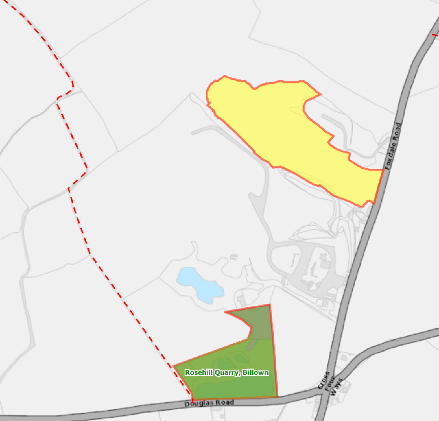
3.1.2 The Constraints map shows an area of Designated Wildlife Site to the north (yellow below), ASSI to the south (green where “Rosehill Quarry, Billown” appears) Manx Wildlife Trust Nature Reserve (olive green with red outline). A public right of way runs to the west of the quarry (red dotted line). These are depicted more clearly on the Island Environment map:
3.1.3 The Written Statement accompanying the Area Plan for the South refers to the wider site in a number of places. The Rosehill ASSI is noted at paragraphs 5.4.1 Billown Wood Wildlife site is referred to at 5.5.4, The high quality of the soil is referred to at 5.10.1 The quarry and site are referred to under “Industrial activity” at 6.12.2 and at 9.4 under “Active Quarries” it states the site “is a limestone quarry used to supply aggregate for the construction industry and the agricultural sector. The quarry is expected to cease extraction of mineral within the next few years.” This has obviously been superseded by the subsequent approval for expansion.
A digital site location map displaying land parcels outlined in red, including a yellow highlighted area and the green 'Rosehill Quarry' zone near Foxdale Road.
3.1.4 The Area Plan refers to the Landscape Character Assessment and adopts its conclusions as follows: the full character area text is set out at Appendix One below.
Ballamodha, Earystane and St Marks (D14)
The overall strategy is to conserve and enhance the character, quality and distinctiveness of the area, with its wooded valley bottoms, its strong geometric field pattern delineated by Manx hedges, its numerous traditional buildings and its network of small roads and lanes. The strategy should also include the restoration of landscapes disturbed by former mining activities.
Key Views Distant views prevented at times by dense woodland in river valleys and by the cumulative screening effect of hedgerow trees, which tend to create wooded horizons. Open and panoramic views out to sea from the higher areas on the upper western parts of the area where there are few trees to interrupt views.
3.1.5 The site is not shown on this plan or on the national flood risk maps as being at risk of any form of flooding.
3.2 Isle of Man Strategic Plan 2016
3.2.1 The Strategic Plan contains a range of policies and statements which are material to the proposal. There is general presumption against development in the countryside other than those which are listed in General Policy 3, which includes (e) location-dependent development in connection with the working of minerals or the provision of necessary services. The plan goes on to discuss minerals in more detail. It states, “12.2.1 The exploitation of the mineral reserves of the Island has been an important part of its history. All round the Island there is evidence of past exploitation. Looking to the future there is a need to ensure an adequate supply to meet our needs but also to ensure that the environmental impacts caused by mineral exploitation are kept, as far as is practicable, to a minimum.” As the site is identified as a Mineral Extraction Site, it is considered that the proposed development accords with the land use designation and as such, the requirements of General Policy 2 are appropriate.
3.2.2 Despite the Strategic Plan stating a proposal to have a Planning Policy Statement on Minerals with the aim of providing a long term assessment of future need for minerals and a
process for identifying a suitable supply of and policies for the identification, assessment, extraction and after-use of sites, there has been no such document prepared.
3.2.3 Nevertheless, there is a policy set out which guides development involving the winning and working of minerals:
Minerals Policy 1: Development involving the winning and working of minerals will be permitted only where it is demonstrated that there is a need for the minerals which cannot be met through the provision of secondary aggregates. Applicants will be required to demonstrate also that;
(a) there would be no unacceptable adverse effect on local residents in terms of visual amenity, dust, noise, or vibration as a result of the on site operation itself (including development, maintenance and restoration) or the traffic generated thereby;
(b) there would be no unacceptable adverse effect on:
i. landscapes and geology/geomorphology features of special interest or attraction;
ii. Ancient Monuments or their settings;
iii. Registered Buildings or their settings;
iv. the character and appearance of a Conservation Areas;
v. sites of archaeological interest;
vi. sites containing species or habitats of international, national and local importance;
vii. land drainage and water resources; and
viii. designated National Heritage Areas;
(c) the proposal is acceptable in terms of access arrangements and highway safety;
(d) working will be in accordance with a phased scheme of restoration and landscaping; and that
(e) the proposal does not sterilise other significant mineral deposits. Exceptionally, national need for a particular mineral may warrant setting aside one or more of these constraints.
An Environmental Impact Assessment will be required for applications including the winning and working of minerals.
3.2.4 In terms of Environmental Impact Assessments, Environment Policy 24 sets out where such information is required:
Environment Policy 24: Development which is likely to have a significant effect on the environment will be required:
i) to be accompanied by an Environmental Impact Assessment in certain cases; and
ii) to be accompanied by suitable supporting environmental information in all other cases.
3.2.5 Appendix 5 lists those developments where an Environmental Impact Assessment is required in every case:
(b) Extractive Industry Quarries Surface industrial installations for the extraction of materials
(e) Mineral industry Any installation for the manufacture of cement, glass, for the smelting of mineral substances and manufacture of ceramic products by burning
There would appear to be nothing within Appendix 5 of the Strategic Plan, nor indeed within the UK regulations which are referred to in the Strategic Plan which would indicated that an Environmental Impact Assessment is required in this case. Whilst both documents refer to
the “winning” and “working” of minerals, neither word describes the processing of the mineral after extraction.
3.2.6 There are policies which protect existing land users from harm through pollution:
Environment Policy 22: Development will not be permitted where it would unacceptably harm the environment and/or the amenity of nearby properties in terms of:
i) pollution of sea, surface water or groundwater;
ii) emissions of airborne pollutants; and
iii) vibration, odour, noise or light pollution.
3.2.7 Additional policies which are relevant including the following which are set out in full at Appendix Two:
Strategic Policies 3 and 4 which require development to have a positive impact on the landscape
Environment Policies 4 and 7 which protect ecology
Environment Policy 1 which protects the countryside for its own sake and
Environment Policy 2 which affords particular protection of sites within areas designated as of High Landscape or Coastal Value and Scenic Significance on the Isle of Man Planning Scheme (Development Plan) Order 1982. The site is so designated on that document.
Environment Policies 40 and 41 protect sites of archaeological importance and sensitivity
4.0 THE PROPOSAL
4.1 Proposed is the installation of plant on the site which would enable mineral extracted from the site to be naturally washed and screened. It involves discharging the material into a hopper at one end of the plant with the material fed through it through a series of conveyors with material screened and separated and stockpiled as it passes through the process.
4.2 The quarry extension at Billown was granted 2019 with excavations to reveal the rock face commencing in 2022. The expected volumes were 689,047 tonnes and the expected life was 9.8 years.
4.3 Following excavations, it was found that a significant proportion of the limestone (the vast majority) is unsuitable for processing due to contamination with a high percentage of dirty fines and clays.
4.4 At present, the machinery in use at the quarry is a crusher and screens that crush the blasted dry rock and screen into various sizes of aggregate. This machinery is unable to process “dirty” rock because the dirt and clay gets stuck in the machinery. Any of the dirty material that can be processed is of lower quality due to the high volumes of dirt and clay.
4.5 The absence of a mineral wash plant (MWP) therefore means the operation cannot process this material and the inferior rock is considered waste. To access the good limestone, the dirty limestone still needs to be blasted, excavated and moved. This greatly increases the cost of the quarrying operation meaning the cost per tonne of usable limestone is greater. After 2 years of struggle, excavations in the extension have been paused due to these difficulties while the viability of the quarry extension is reconsidered.
4.6 Available quarry resources are scarce on the Island and once exhausted, a greater volume of aggregate will need to be imported.
4.7 The MWP will extend the life of the quarrying activity at Billown by maximising the production of extracted material from the quarry resource into a saleable aggregate. It will allow the operation to process the inferior rock but it also creates a greater range of high quality material by producing clean aggregates from larger sizes down to sand with a much smaller volume of waste.
4.8 Billown quarry has received planning permission for the disposal of inert waste (see Planning History). As the MWP will enable the production of more resource from the quarry, it will create a greater void space and this will extend the life of the tip.
4.9 The MWP will enable the incoming inert waste materials to be washed and processed to recover clean aggregates such as sand, gravel, and crushed stone. This not only reduces the need for primary extraction elsewhere but also supports the circular economy by diverting material from landfill and extending the life of the landfill. The MWP will not crush the material, it sorts and washes it. There is already a crushing and screening system on the wider site but the wash plant will produce a greater range of materials and of much higher quality. The crusher presently on site cannot process dirty material but the wash plant will be able transform what looks like dirt into a range of aggregate and sand products, enhancing the sustainability of the operation.
4.10 The MWP will enable more sustainable water management due to the recirculation of water resource. Improved dust control in the quarry due to the nature of washing rather than crushing and screening of dry aggregate as is done at present
4.11 The main wash plant (ie. the washing & screening part) would be operated during normal quarry licensed working hours (Mon-Fri 0700-1800hrs, Sat 0700-1300hrs with maintenance of plant permitted to be carried out within these hours and between 0700hrs and 1630hrs on a Saturday and between 0800hrs and 1630hrs on a Sunday). The sludge plant would run overnight but this is an automated part of the operation that simply pumps water from the big sludge tank through filter
4.12 It should be noted that the MWP plant is effectively just like the normal screening equipment, except that it also uses a closed loop of water to separate the finer materials into constituent products of small sized aggregates and sands, rather than disposing into the quarry. The new plant will not be as noisy as the existing primary and secondary crushing activities as is evident from the noise impact information provided.
4.13 The proposed MWP will have a footprint which covers an area of approximately 60m by 41m at its widest and longest and the tallest part of the plant will be just under 14m above ground level. The plant comprises a series of conveyors which undertakes the following process:
The large limestone rocks extracted from the quarry are already broken down into smaller sizes (aggregates) using crushers and then screened to separate them into different size fractions as part of the existing processes on site.
Washing: The screened aggregates can then be washed to remove clay, silt, and other unwanted materials some of which are recyclable and separated.
Dewatering: After washing, the aggregates are dewatered, typically through specialised screens and cyclones, to reduce moisture content.
Fine Material Recovery: Fine limestone particles that may be lost during the washing process are recovered, preventing waste and maximising resource utilisation.
4.14 Drainage and flooding
4.14.1 There is currently no formal surface water drainage network for the site and surface water run off freely discharges to the ground and infiltrating the existing groundwater table. The water used in the process when discharged, will be directed to the ground, as is the existing groundwater, but via an infiltration basin designed as a natural flow path to the southern quadrant of the site. The groundwater system has been designed to a 1% AEP (1:100 year return period) plus 20% climate change and 3.3% AEP (1:30 year return period). The Flood Risk Assessment prepared by Egniol Consulting Ltd, dated July 2025 explains this and its impacts in more detail.
4.14.2 Access to and from the site will not be changed and will not be affected by the proposal.
4.15 Ecology
4.15.1 An ecological impact report has been prepared by Evergreen Ecology dated July 2025 based upon a desktop study and walk over survey in June 2025. T
4.15.2 The report identifies the adjacent ASSI at Rosehill Quarry as being 95m from the proposed development and describes the site as a whole as contained baseline area habitats of sparsely vegetated land both as the actively worked quarry and ruderal or
ephemeral with mixed scrub. The areas of natural habitat are limited to made ground adjacent access tracks and a scrubbed embankment adjacent to a gravel car parking area.
4.15.3 They identify potential indirect impacts on the ASSI from the development as well as on the Billown Nature Reserve, Billown Wood Wildlife Site but suggest that due to the distance from the site, there would be no impacts anticipated to the two non statutory designated sites at Great Meadow (1.1km) and Upper Silverdale (1.4km).
4.15.4 The report explains that whilst the Rosehill Quarry ASSI, Billown NR and Billown Wood (WS) are wholly outside the development site, due to their proximity there is the potential for the proposed development to cause indirect impacts through dust creation and water runoff pollution. It refers to the current pollution prevention measures at the site as to avoid causing impacts in these respect. There is also an embankment in place separating the site from the newly created habitat within Billown NR and which also provides a barrier to any incidental pollution runoff and this will remain in place.
4.15.5 The report confirms that the quarry operators worked closely with Manx Wildlife Trust throughout the contraction and operation of the existing quarry and have created new areas of habitat linked to the ASSI to maintain its conservation status. All this will continue during the installation and operation of the proposed wash plant to ensure that the ASSI’s qualifying features continue to thrive. As such, It is concluded that there will be no impacts anticipated on the nearby designations.
4.15.6 The site has the potential to support a small number of protected species including nesting birds and common frog and the clearance of vegetation required for the development has the potential to cause disturbance to these species. Ideally the works will be undertaken outside of the bird breeding season but in the event works to existing habitats is required during the breeding bird season (March to September) the report advises that a nesting bird check should be undertaken by a Suitably Qualified Ecologist (SQE) a maximum of 48 hours prior to works commencing in order to adhere to all relevant legislation. In the event of an active nest being identified then a suitable no works buffer (5m) will be implemented until chicks have fledged and the nest is no longer in use. As a precaution, the area of mixed scrub will be cleared through a two stage cut. The first cut will be to 100mm following which the area will be left for 24 hours to allow any common frog to move out the area into adjacent retained habitat. The area will be checked by the clearance
operatives to ensure absence of common frog before the second cut to ground level. An ecologist will be on call to advise in the event common frog are identified during the works.
4.16 Landscape and visual impact
4.16.1 A Landscape and Visual Impact Assessment (LVIA) has been prepared by House Associates, dated July 2025 and is submitted with the application. It notes that the bulk of the plant will not be visible outside the quarry and as it is to be clad in dark green sheeting, this will further reduce any possible visual impact. It explains at the lower elements the MWP will be lit during the winter months at a height no greater than 3m and the floodlighting will be directed down only so as not to spill any light into the wider landscape and so as not to be publicly visible.
4.16.2 It concludes that overall there would be, at worst a slight adverse impact on landscape character which is based upon the relatively few places from which the proposed development will be visible combined with the proposed finish materials and colour, intervening topography and vegetation and the distances involved. It states that in terms of cumulative impact there is only one place from where the upper part of the MWP will be seen with the existing coating plant and given that the proposed MWP will be clad in dark green sheeting and seen against a backdrop of trees, any additional visual impact will be minimal.
4.16.3 The report considers the existing topography and intervening landscape features which will prevent any significant view of the proposal such that the proposed development would have an acceptable impact on the landscape.
4.17 Noise
4.17.1 A report into the impact of the proposed plant from noise and dust has been prepared by e3p (Environmental Engineering Partnerships Ltd) and is submitted with the application. It concludes that the proposed plant will not result in any noise levels above those which are currently emanating from the quarry and bitumen plant and that from the nearest noise sensitive receptors - the nearest dwellings and Broom House, the noise levels from the plan will not exceed acceptable thresholds.
4.17.2 The assessment has found that the predicted rating level from the proposed plant would be at least 5 dB below the existing background sound level which suggests no adverse impact and limits noise creep of existing specific sound levels from existing
quarry.Furthermore, the predicted noise level falls below the PPG criterion for mineral workings. As such, no adverse impact is predicted.
4.18 Dust and particulates
4.18.1 The application includes a Dust and Particulate Management Plan prepared by Egniol Consulting Ltd and dated July 2025 which identifies the source of potential dust creation and ways in which any potential issue will be resolved. It explains that mobile plant and pumps are potential point sources of emissions of particulates to air. The principal type of such emissions would be unburned or part-burned fuel oil in exhausts from internal combustion engines (black smoke).
4.18.2 It also suggests that there is a risk of emissions of particulates to atmosphere arising from the raw minerals themselves during transport from the face to the wash plant. The asblasted stone will be transported from the face to the wash plant in open bodied trucks where it will be tipped into a stockpile from where it will be loaded into the hopper of the wash plant.
4.18.3 It confirms that this operation of loading and transporting the as-blasted rock is no different from that already carried out on the site however, the as-blasted material is currently crushed and dry screened which represents a far greater risk of fugitive emission compared to the proposed wash plant as the raw material is wetted up early in the process reducing this risk significantly. Notwithstanding this, suitable dust suppression techniques will be employed during periods of dry weather, such as dampening the as-blasted rock at the face, to minimise this risk.
4.18.4 The report identifies that there is a risk of emissions of particulates to atmosphere from vehicles driving along the haul road to the wash plant. Suitable dust suppression techniques will be employed during periods of dry weather, such as dampening the roads, to minimise this risk. There is a risk of emissions of particulates to atmosphere when vehicles are discharging their loads at the wash plant. This is particularly so where fine and dry loads are involved. Such emissions are to be minimised by ensuring that the dust suppression is used during periods of dry weather.
4.18.5 It also raises the residual risk that, despite the avoidance and prevention measures described previously, there may still be particulate matter emitted into the atmosphere. It will
be a subjective judgment of the site manager as to whether or not such emissions are liable to leave the site boundary and present a nuisance to others.
4.18.6 If there is a real risk of particulate matter leaving the site and becoming a nuisance to others, the site manager is to close the site to those operations that are giving rise to the nuisance without unjustifiable delay. The operation on site will also employ speed limits for traffic, the use only of proprietary plant and equipment and appropriate, regular maintenance of all machinery. If issues arise, the source of the dust will cease operation until the issue is resolved.
4.18.7 Monitoring will be undertaken and reported using the form attached to the Particulates Management Plan.
4.18.8 The site itself has permission for clearance of the existing overburden through 22/00922/B to the levels shown in the current application.
5.0 CONCLUSION
5.1 The site is identified as a quarry in land use planning terms and has planning approval for continued extraction of limestone as well as the operation of a bitumen plant and inert waste disposal.
5.2 What is proposed will make the quarry operation and restoration more efficient, maximising the product available at the end of the process and improving the quality of the mineral.
5.3 It is our position that there is nothing within Appendix 5 of the Strategic Plan, nor indeed within the UK regulations which are referred to in the Strategic Plan which would indicate that an Environmental Impact Assessment is required in this case. Whilst both documents refer to the “winning” and “working” of minerals, neither word describes the processing of the mineral after extraction.
5.4 Nevertheless, we fully appreciate that adequate information must be provided within the application in order that the impact of the development may be properly assessed. In this respect we have identified that the following impacts should be considered in detail:
• Noise impact on nearby residents
• Visual impact on the countryside
• Provisions for drainage and disposal of waste water from the proposed process and flood risk
• Impact on ecology, noting the proximity of the ASSI
• Impact on any archaeology
• Information on how the installation will affect the operation of the existing lawful processes on the site.
Noise
5.5 The application contains professionally sourced information on the impact of the development in terms of noise, concluding that the proposed facility will not result in noise levels above those which are currently generated on the site and that cumulatively the noise emitted from the proposed development would be within acceptable levels of adjacent noise sensitive premises. The plant will be operational at the same times as the quarry and we would be happy with a condition to that effect.
5.6 In terms of noise impact, we would submit that the application satisfies Environment Policy 22.
Visual Impact
5.7 The LVIA demonstrates that whilst a very small part of the proposed MWP would be visible from a small number of public vantage points, the visual impact of this on the character and appearance of the area would be acceptable, noting that the site is already clearly visible as a quarry and bitumen plant with the associated traffic and visual impact.
5.8 The proposed development is therefore considered to be in accordance with Environment Policies 1 and 2, Strategic Policies 3 and 4, Minerals Policy 1 and General Policy 2 and the Landscape Character Assessment as originally published and as summarised in the Area Plan for the South.
Drainage and flood risk
5.9 The Drainage and Flood Risk report demonstrates that the proposed MWP will have an acceptable impact in terms of drainage and neither be at unacceptable risk or, or increase the risk of flooding to other property. The introduction of an infiltration basin within the site will improve the method of dealing with surface water within the site.
5.10 The proposal is therefore considered to accord with Environment Policies 7 and 22.
Ecology
5.11 The information provided in the Ecological Report demonstrates that the proposed MWP will not have a harmful impact on ecology, including the adjacent ASSI, Nature Reserve and Wildlife Sites. The proposed development is therefore in accordance with Environment Policies 4 and 7 and General Policy 2.
Archaeology
5.12 The proposed plant is not permanent and will remain on site for as long as the quarry is operational and restoration complete. There is no excavation proposed so no effect on any archaeological material within the site. As such, the proposal satisfies Environment Policies 40 and 41.
Impact on the lawful processes within and use of the site
5.13 The proposed plant will be in an area which is not currently used and its function is complementary to the existing operations. There will therefore be no adverse impact on the existing lawful processes within the site. The application will complement rather than adversely affect the working and processing of the minerals at this site and thus support Minerals Policy 1 and the Area Plan for the South.
5.14 We would submit that the information provided satisfies the requirements of Environment Policy 24.
5.15 There is no impact on highway safety as the plant will not generate any additional traffic once in situ and would, as has been demonstrated above, not result in any adverse impact on the appearance and character of the area, on the living conditions of those living in the area or any of the other receptors listed in General Policy 2.
5.16 Whilst there is a presumption against development in the countryside, General Policy 3 is clear that location-dependent development in connection with the working of minerals or the provision of necessary services can be an acceptable exception, supported by Minerals Policy 1 with which we would also submit the application accords. The continued provision of minerals from an on Island source is vital to the sustainability of the Island’s economy and industry and what is proposed will increase the efficiency and sustainability of Billown Quarry with, we would submit, no harmful environmental impact.
Sarah Corlett 17.07.25
APPENDIX ONE
Excerpt from the Landscape Character Assessment 2008 D14 – BALLAMODHA AND ST MARK’S Key Characteristics
• Land slopes down from the southern uplands towards the coast.
• Numerous deeply incised wooded river valleys and glens cut down into the landscape forming ribbons of fragmented woodland.
• National Glens at Silverdale and Colby
• Settled farmland character with some large nucleated settlements along the A7, small villages and a variety of scattered dwellings and farms.
• Smaller predominantly rectangular pastoral fields with Manx hedges topped with gorse on the upland slopes to the north.
• Patches of gorse, bracken and heather in fields on the upper slopes.
• Larger rectilinear pastoral and arable fields with large deciduous trees growing on Manx hedges on the more gently sloping southern slopes.
• Around the various settlements and farms there are smaller rectangular arable and pastoral fields with Manx hedgerows containing numerous trees and some stone walls.
• Network of tracks, small lanes and larger roads enclosed by substantial hedgerows containing deciduous trees all growing on grass covered Manx hedges.
• Numerous small reservoirs and water bodies associated with water courses.
• Some small churches with spires as well as various standing stones and other visible archaeological sites.
• Presence of Manx Milestones.
• Quarries at Turkeyland and at Billown.
Overall Character Description Land slopes steeply down from the southern uplands with small rectangular fields of rough pasture containing patches of gorse and some bracken in places where these upland species have spread out from the low Manx hedges. A variety of predominantly stone hill farms with numerous outhouses surrounded by fragmented woodland, such as Ballaglashan and Glenmoar Farm, are located on these steeper slopes. The tight geometric field pattern on these slopes loosens as the slope angle becomes shallower with larger, predominantly angular but irregularly shaped fields of grazing and agriculture covering the majority of the
flatter southern area. Smaller fields surround the various small clustered settlements. There are also groups of trees surrounding these settlements (e.g. the more traditional village of St. Mark’s with its stone houses, church and conservation area) and also around loosely clustered dwellings such as those along the A34 north of Ballasalla. Located along the busy A7 road are the two larger nucleated settlements of Ballabeg and Colby whose traditional fabric has been added to with numerous modern extensions that back onto small fields with some screening in the form of mature trees in surrounding hedgerows.
Through this gently sloping and undulating landscape cut numerous steep sided deep and heavily vegetated river valleys, including Colby River, Silver Burn and Santon Burn, with numerous smaller tributaries joining their courses along with various rectilinear drainage ditches. These wooded valleys form sinuous fingers of fragmented woodland that cut across and disrupt the field pattern and otherwise gently sloping landform. Colby Glen and Siverdale Glen are designated both as conservation areas and National Glens. These glens were developed during the Victorian times to allow visitors waterside access and a chance to experience these enclosed valleys and their lush riparian vegetation by way of footbridges and paths with handrails to promenade. Many original features remain today.
A network of small tracks, narrow roads and larger A roads traverse the area and are predominantly contained by steep sided grassy banks of the Manx hedgerows that line the roads, with varying hedgerows, some containing trees in places. There is a settled but semirural character. There is a relatively strong sense of tranquillity that pervades much of the area. Wooded horizons are common in most places, creating an intimate contained and continuous character. The steep sided Glens break what would otherwise be a relatively monotonous landscape to create active and dramatic elements that one can descend down into from the surrounding fields.
Key Views
• Distant views prevented at times by dense woodland in river valleys and by the cumulative screening effect of hedgerow trees, which tend to create wooded horizons.
• Open and panoramic views out to sea from the higher areas on the upper western parts of the area where there are few trees to interrupt views.
Historic Features
• Numerous chapels and churches including Columbus Church and Kirk Santon with Medieval crosses
• Standing stones and some earthworks
• Rushen Abbey (Cistercian) and Monks Bridge
• Silverdale watermill and roundabout
Ecological Features
• Farmland grassland habitats
• Mature network of hedgerows containing deciduous trees in field boundaries
• Aquatic and waterside habitats along river courses
• Dense riparian woodland in Glen bottoms
• Fragmented blocks of deciduous woodland
• Bird sanctuary at junction of A34 and A3
Evaluation of Inherent Landscape Sensitivities
• Mixture of field size and pattern with various hedges containing a variety of vegetation.
• Fragmented woodland in valley bottoms and along National Glens.
• Rivers and reservoirs with aquatic ecosystem with riparian habitats.
• Built up edge of Ballasalla and nucleated settlements of Ballabeg and Colby.
• Scattered traditional farms and hamlets fringed by deciduous woodland.
• Network of tracks, small lanes and larger roads enclosed by substantial hedgerows containing deciduous trees all growing on grass covered Manx hedges.
• Sites of archaeological importance.
• Manx Milestones by roadside.
• Victorian Isle of Man Steam Railway station and halts.
Landscape Strategy The overall strategy for the area should be to conserve and enhance the character, quality and distinctiveness of this farmed landscape with various field patterns defined by different hedges, a scattered settlement pattern of traditional hamlets, farmsteads and nucleated settlements fringed by trees, a varied road network enclosed by grassed Manx hedges and roadside vegetation, and numerous wooded valleys and glens. In addition to the conservation of archaeological sites, measures should also be adopted to conserve and enhance the physical structure and setting of upstanding heritage features such as the Silverdale watermill.
APPENDIX TWO
Excerpt from the Isle of Man Strategic Plan 2016
Strategic Policy 4: Proposals for development must: (a) Protect or enhance the fabric and setting of Ancient Monuments, Registered Buildings(1), Conservation Areas(2) , buildings and structures within National Heritage Areas and sites of archaeological interest; (b) protect or enhance the landscape quality and nature conservation value of urban as well as rural areas but especially in respect to development adjacent to Areas of Special Scientific Interest and other designations; and (c) not cause or lead to unacceptable environmental pollution or disturbance.
Strategic Policy 5: New development, including individual buildings, should be designed so as to make a positive contribution to the environment of the Island. In appropriate cases the Department will require planning applications to be supported by a Design Statement which will be required to take account of the Strategic Aim and Policies.
General Policy 2: Development which is in accordance with the land-use zoning and proposals in the appropriate Area Plan and with other policies of this Strategic Plan will normally be permitted, provided that the development:
(a) is in accordance with the design brief in the Area Plan where there is such a brief;
(b) respects the site and surroundings in terms of the siting, layout, scale, form, design and landscaping of buildings and the spaces around them;
(c) does not affect adversely the character of the surrounding landscape or townscape;
(d) does not adversely affect the protected wildlife or locally important habitats on the site or adjacent land, including water courses;
(e) does not affect adversely public views of the sea;
(f) incorporates where possible existing topography and landscape features, particularly trees and sod banks;
(g) does not affect adversely the amenity of local residents or the character of the locality;
(h) provides satisfactory amenity standards in itself, including where appropriate safe and convenient access for all highway users, together with adequate parking, servicing and manoeuvring space;
(i) does not have an unacceptable effect on road safety or traffic flows on the local highways;
(j) can be provided with all necessary services;
(k) does not prejudice the use or development of adjoining land in accordance with the appropriate Area Plan;
(l) is not on contaminated land or subject to unreasonable risk of erosion or flooding;
(m) takes account of community and personal safety and security in the design of buildings and the spaces around them; and
(n) is designed having due regard to best practice in reducing energy consumption.
General Policy 3: Development will not be permitted outside of those areas which are zoned for development on the appropriate Area Plan with the exception of:
(a) essential housing for agricultural workers who have to live close to their place of work; (Housing Policies 7, 8, 9 and 10);
(b) conversion of redundant rural buildings which are of architectural, historic, or social value and interest; (Housing Policy 11);
(c) previously developed land(1) which contains a significant amount of building; where the continued use is redundant; where redevelopment would reduce the impact of the current situation on the landscape or the wider environment; and where the development proposed would result in improvements to the landscape or wider environment;
(d) the replacement of existing rural dwellings; (Housing Policies 12, 13 and 14);
(e) location-dependent development in connection with the working of minerals or the provision of necessary services;
(f) building and engineering operations which are essential for the conduct of agriculture or forestry;
(g) development recognised to be of overriding national need in land use planning terms and for which there is no reasonable and acceptable alternative; and
(h) buildings or works required for interpretation of the countryside, its wildlife or heritage.
Environment Policy 1: The countryside and its ecology will be protected for its own sake. For the purposes of this policy, the countryside comprises all land which is outside the settlements defined in Appendix 3 at A.3.6 or which is not designated for future development on an Area Plan. Development which would adversely affect the countryside will not be permitted unless there is an over-riding national need in land use planning terms which outweighs the requirement to protect these areas and for which there is no reasonable and acceptable alternative.
Environment Policy 2: The present system of landscape classification of Areas of High Landscape or Coastal Value and Scenic Significance (AHLV’s) as shown on the 1982 Development Plan and subsequent Local and Area Plans will be used as a basis for development control until such time as it is superseded by a landscape classification which will introduce different categories of landscape and policies and guidance for control therein. Within these areas the protection of the character of the landscape will be the most important consideration unless it can be shown that:
(a) the development would not harm the character and quality of the landscape; or
(b) the location for the development is essential.
Environment Policy 4: Development will not be permitted which would adversely affect:
(a) species and habitats of international importance:
(i) protected species of international importance or their habitats; or
(ii) proposed or designated Ramsar and Emerald Sites or other internationally important sites.
(b) species and habitats of national importance:
(i) protected species of national importance or their habitats; (1) Wildlife Sites are defined in Appendix 1 41
(ii) proposed or designated National Nature Reserves, or Areas of Special Scientific Interest; or
(iii) Marine Nature Reserves; or
(iv) National Trust Land.
(c) species and habitats of local importance such as Wildlife Sites, local nature reserves, priority habitats or species identified in any Manx Biodiversity Action Plan which do not already benefit from statutory protection, Areas of Special Protection and Bird Sanctuaries and landscape features of importance to wild flora and fauna by reason of their continuous nature or function as a corridor between habitats.
Some areas to which this policy applies are identified as Areas of Ecological Importance or Interest on extant Local or Area Plans, but others, whose importance was not evident at the time of the adoption of the relevant Local or Area Plan, are not, particularly where that plan has been in place for many years. In these circumstances, the Department will seek site specific advice from the Department of Agriculture, Fisheries and Forestry if development proposals are brought forward.
Environment Policy 7: Development which would cause demonstrable harm to a watercourse, wetland, pond or dub, and which could not be overcome by mitigation measures will not be permitted. Where development is proposed which would affect a watercourse, planning applications must comply with the following criteria:
(a) all watercourses in the vicinity of the site must be identified on plans accompanying a planning application and include an adequate risk assessment to demonstrate that works will not cause long term deterioration in water quality;
(b) details of pollution and alleviation measures must be submitted;
(c) all engineering works proposed must be phased in an appropriate manner in order to avoid a reduction in water quality in any adjacent watercourse; and
(d) development will not normally be allowed within 8 metres of any watercourse in order to protect the aquatic and bankside habitats and species.
Copyright in submitted documents remains with their authors. Request removal
Source & Provenance
Official reference
25/90717/B
Source authority
Isle of Man Government Planning & Building Control