Environmental Statement Chapter 3 Development Description
25/90698/B·11 pages·PDF
Reports›Planning Statement
115 of 137use ← → arrow keys
Loading document...
Environmental Statement Chapter 3 Development Description
3 DEVELOPMENT DESCRIPTION
3.1 Introduction
3.1.1 This Chapter of the ES describes the Proposed Development, a summary of the design process and indicative details of the development phasing and timescales.
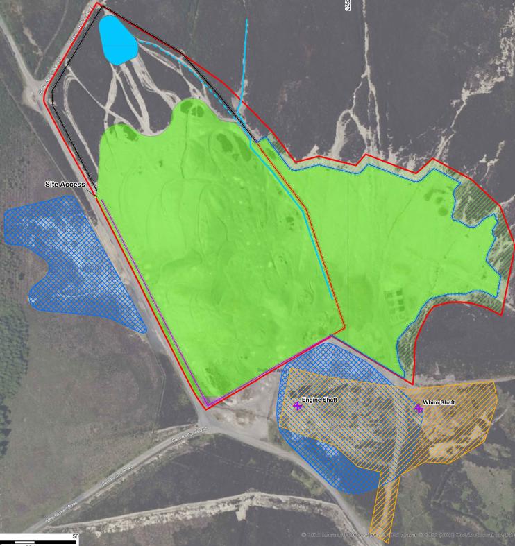
3.1.2 This ES is based on the plan included at Appendix 3.1 and illustrated in Figure 3.1 below, and briefly comprises:
3.1.3 ’Transportation of sediment from the Peel silt lagoon to Cross Vein Mine (the Site), treatment of it on the Site, and thereafter its use in remediation of the Site including capping works. The Proposed Development will also include the construction of a settlement pond, temporary treatment plant, work access tracks, drainage ditches, fencing and landscape works.’
Figure 3.1: Overview of Remediation Works on Site (Wardell Armstrong, 2025)
3.1.4 For the purposes of this ES, there will be two phases of the Proposed Development assessed:
• Remediation phase:
o transport of sediment from the temporary lagoon to Cross Vein;
o construction of settlement pond at Cross Vein;
o treatment of the sediment for re-use on the mine site; and
o the remediation of an area of the mine known as ‘the deads’ by applying a capping layer and growing medium.
• Post-remediation phase: o The long-term state of the site following completion of works.
3.2 Background
3.2.1 Periodic dredging is undertaken at Peel Marina due to the build-up of sediment which reduces safe depths for commercial vessels and restricts access to berths. Peel Marina was most recently dredged in 2020 and 2021 with approximately 23,000 m3 of sediment removed. However, chemical analysis of the sediment in the marina recorded concentrations of lead that exceeded Centre for Environment, Fisheries and Aquaculture Science (Cefas)1 Action Levels so the sediment could not be deposited out at sea. The sediment has therefore been stored in a temporary dewatering lagoon under a planning permission granted in March 2019 (Ref: 18/01293/B). The sediment has since dewatered to an approximate volume of 16,000 m3.
3.2.2 The source of the heavy metal contamination in the marina sediment is considered to be from several metalliferous mines located within the River Neb catchment including the Cross Vein Mine.
3.2.3 The planning permission for the temporary lagoon is currently in the process of being renewed to extend the lifetime of both the lagoon and the discharge pipelines along the River Neb between Ballaterson Farm and Peel Marina, to December 2027 (Ref: 24/00301/B). The planning application covers both the ongoing operation and decommissioning of the temporary lagoon facility.
3.2.4 A scheme to treat the sediment currently stored in the lagoon to make it suitable for re-use as part of a remediation scheme at Cross Vein Mine is now proposed, and it is the works associated with this scheme that form the Proposed Development assessed in this ES.
3.3 The Proposed Development
3.3.1 The Proposed Development aims to treat approximately 16,000 m³ of sediment currently stored in the lagoon, making it suitable for reuse in a remediation scheme at
1 The Centre for Environment, Fisheries and Aquaculture Science (Cefas) is an agency of the Department of Environment, Food and Rural Affairs (DEFA) that collects, manages and interprets data on the aquatic environment, biodiversity and fisheries.
Cross Vein Mine. The remediation works will address 4.3 ha of mining spoil known as the ‘deads,’ which was previously used for metal ore processing. The primary objective is to mitigate migration of heavy metals into the River Neb catchment and Peel Marina. It is proposed that the treated sediment is used as a capping layer across the ‘deads’ to reduce surface run-off and leaching of the underlying heavy metal impacted soils currently at the surface. The capping layer would serve to break or weaken potential pollution linkages and mitigate the risks.
3.3.2 The recent topographical survey of the site shows the existing levels range between 238.86 mAOD and 253.00 mAOD; therefore, assuming a capping layer of between 500
– 800 mm, the anticipated post-remediation levels will be between 239.36 mAOD and 253.80 mAOD. The exact thickness of the cap and the final levels will be confirmed at detailed design stage but are not considered likely to differ significantly. The capping layer will be graded at the edges of the site to tie into the levels of the adjacent areas. Due to the undulating nature of the surrounding land there is unlikely to be a noticeable increase in elevation post-remediation particularly once the site becomes re-vegetated.
3.3.3 This remediation process will comprise three stages; enabling works, treatment of sediment and capping of the mining spoil. It will begin with the collection and transportation of the sediment from the dewatering lagoon to the Cross Vein Mine Site, where it will be treated. It is considered that the most likely form of treatment will be ex-situ chemical and physical stabilisation / solidification of the sediment to make it suitable for use as part of the capping layer. The treated sediment will be combined with an imported growing medium (topsoil) layer, approximately 150 millimetres (mm) in depth, to facilitate the restoration of the Site to heathland.
3.3.4 The proposed capping area and main components of the remediation strategy are illustrated in Figure 3.1 (and Appendix 3.1). Remediation Phase Enabling Works
3.3.5 The enabling works will comprise the collection and transport of the 16,000 m3 of dewatered dredged sediment from the lagoon to the mine, construction of a settlement pond and the set-up of plant at the mine site to enable sediment treatment and site remediation through capping.
3.3.6 There is an existing area of hardcore forming a haul road around the lagoon providing ease of vehicle access to remove the sediment. The sediment will be removed from the lagoon by an excavator and placed onto a dumper truck before being transported to a heavy goods vehicle (HGV) for transport to Cross Vein Mine.
3.3.7 The dredged sediment will be transported to Cross Vein Mine within three months, between August and October 2026, with an estimated 8 m3 per HGV load. Assuming a 22-day working month, the average number of HGV movements per day is expected to be 60 two-way movements per day (30 arrivals and 30 departures).
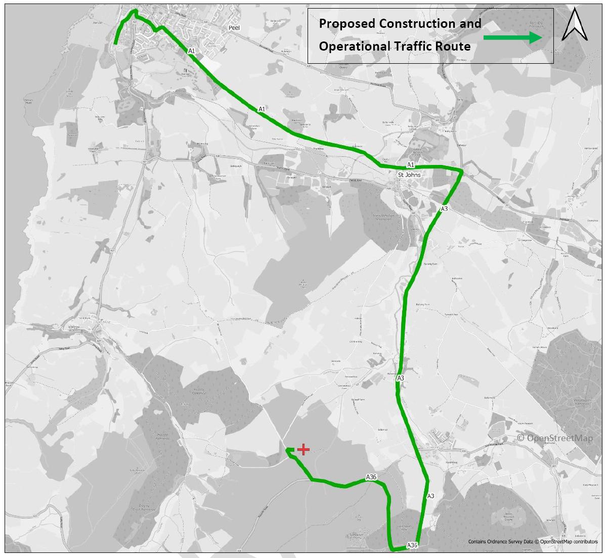
3.3.8 The proposed route of the HGVs is shown in Figure 3.2. The route heads north from the dewatering lagoon in Peel along Mill Road until this adjoins Station Road. The route then goes onto the A27 and through Heathfield Drive and Queens Drive. The roundabout on Queens Drive then leads onto the A1. The A1 is followed 4.7 km east until the crossroads at St John’s, where the A1 and A3 intersect. The A3 is then followed for 5.3 km south through Lower Foxdale and Foxdale until a right turn onto the A36. The A36 is then followed until Glen Rushen Road which then leads to Cross Vein Mine.
Figure 3.2: Proposed Transport Route (Wardell Armstrong, 2025)
3.3.9 It is anticipated that the number of staff to be undertaking work during the transportation of the sediment will be 5-10 operating between 8am and 6pm Monday to Friday and between 9am and 2pm on Saturday. A temporary access track/area of hardstanding may be required at the mine Site to enable the HGVs to offload the sediment for treatment.
A location map displaying a proposed green traffic route from Peel to a site marked with a red cross.
3.3.10 An area likely to be 20 m x 20 m will be allocated for the temporary treatment plant, this will be in the north of the Cross Vein Mine Site to avoid the mine workings and the ecological exclusion zones, in place to protect areas of bryophytes. The treatment area will be located near to the stockpiled sediment, and comprise water storage tanks, a grout pump, a batching plant, storage of stabilisation agents and fuel storage. The treatment area will be contained to prevent contamination of the surrounding area via infiltration. The method of containment will be confirmed at the detailed design stage but is anticipated to comprise the stockpile being placed on an impermeable membrane and bunded.
3.3.11 Furthermore, the landscaping works are anticipated to blend with the surrounding scape with the sowing of suitable native plant species such as grasses for acid soils. This will be confirmed at detailed design stage.
3.3.12 The exact details of the temporary treatment area will be confirmed once a contractor is appointed for the project, but indicatively we anticipate that the temporary treatment area will be around 20 m by 20 m and will typically comprise grout batching plant, cement/additive storage, water storage and grout pump. The plant used is a typical excavator around 3 m high and a grout batching plant around 1.5 m high. The treatment area is likely to covered in an impermeable membrane and within a containment bund which is typically around 500 mm high and less than a metre wide and is usually constructed from the existing ground if suitable. The temporary treatment area will be in the northern area of the site to avoid the mining and ecological exclusion zones and will be removed at the end of the site works. There would also be one or two site cabins for office and welfare of the Site workers, details of which can be agreed by a suitably worded planning condition.
3.3.13 To manage potential surface water run-off, a settlement pond will be constructed in the north of the site to trap any mobilised sediment and limit contamination of the River Neb catchment during the works. The positioning of the pond is to avoid the mine workings and ecological exclusion zones. To further limit water run-off, suitable sediment traps will be installed during construction of settling pond. Treatment
3.3.14 The sediment is not suitable for reuse in its current form given the risk posed to the water environment and therefore it requires treatment to be re-used as part of the
capping layer. The treatment of the sediment from the dewatering lagoon will take place on the site.
3.3.15 The main objectives of the capping layer at Cross Vein Mine are:
• Physical – reduce the infiltration of rainfall into the mining spoil, reduce the formation of channels in the mining spoil from surface run-off and the mobilisation of the fine-grained fraction of the mining spoil being transported towards the River Neb catchment.
• Chemical – reduce leaching of lead, zinc and copper from the mining spoil.
3.3.16 The sediment needs to be treated to create a suitable material to address the above physical and chemical requirements, whilst not causing an increase to the contaminant loading at the site. On this basis, it is considered that the most likely form of treatment is chemical and physical stabilisation/solidification of the sediment.
3.3.17 Stabilisation/solidification is a well-established remediation technique for reducing the leaching of heavy metals in soils. To lock in heavy metals into soil/waste, the sediment needs to be stabilised through the addition of binder material such as cement and other specific binder additives. The additives result in the chemical fixation of soluble species into more insoluble, chemically stable compounds, therefore reducing leaching. By treating the sediment, a new more solid material is created. This new material slows contaminant release rate and prevents contaminants from entering the environment at unacceptable levels.
3.3.18 Site-specific remedial targets for the protection of the water environment around Cross Vein will be derived and agreed with DEFA. The treated sediment will not exceed these targets to be considered suitable for re-use at Cross Vein Mine.
3.3.19 For the treatment phase at Cross Vein, 10-15 staff would work between 8am and 6pm Monday to Friday and between 9am and 2pm on Saturday. However, extended hours and/or further weekend work may be feasible owing to the isolated nature of the mine and would be agreed with DEFA if required. Temporary welfare facilities will be provided for staff.
3.3.20 An excavator and dumper truck will move the sediment around the Site during both treatment and capping.
Capping
3.3.21 Capping will consist of the ‘deads’ being reprofiled and capped with the treated sediment and a suitable growing medium. The growing medium will be seeded to complete the remediation of the project.
3.3.22 Due to the Site’s previous use by unauthorised off-road vehicles, re-profiling work is required prior to the placement of the capping layer to create a more even topographic profile to facilitate capping and promote efficient drainage.
3.3.23 An existing ditch towards the east of the site will be realigned to run into the new settlement pond at the beginning of the re-profiling and capping works to capture mobilised sediment. A series of sediment control measures such as leaky dams and engineered heather bales have already been installed in several water channels across the wider Cross Vein Mine by DEFA to trap finer-grained sediment transported by surface run-off during rainfall events from the ‘deads‘ area. DEFA will be responsible for maintaining the settlement pond after the remediation works has been completed. If the pond requires periodic dredging, it is considered that the heavy metals concentrations in the sediment are likely to reduce following the remediation of the area and therefore, dredged material may be suitable for disposal at landfill on island subject to further chemical assessment.
3.3.24 Temporary sediment controls such as heather bales, coir logs or sedimats will be implemented as necessary during the remediation works to prevent the migration of fine-grained sediments into the River Neb catchment, which may become mobilised during the works.
3.3.25 Following completion of the works, the settlement pond will be cleaned out and any sediment dredged from the pond will be chemically assessed and disposed of at a suitable facility or, if feasible, treated to an appropriate specification for re-use as part of the capping layer.
3.3.26 Approximately 4,000 – 5,000 m3 of growing medium (topsoil) for acid grassland and heather will need be sourced from elsewhere on island. This is anticipated to be transported to the Site over a period of around a month between October and November 2026. Assuming a 22-day working month and an estimation of circa 8 m3 per load, the average number of HGV movements per day associated with this aspect of work is expected to be 58 two-way movements (29 arrivals and 29 departures.
3.3.27 The growing medium will comprise a clean low fertility soil capable of supporting native upland flora such as heather, common bent, cotton grass and blaeberry. Parts of the remediation site that support calaminarian grassland will be retained and, if feasible, enhanced. Post-Remediation Phase
3.3.28 The successful establishment of native vegetation will further stabilise the engineered capping layers, limiting downstream dispersal of sediments. The Site will ultimately naturalise and once again become part of the ecologically significant surrounding heathland. It is anticipated that the end use of the Site will eventually be Public Land Open to Ramblage, corresponding with the current designation. However, given the nature the Site, even with management to maintain optimum conditions, it is anticipated that the new heathland habitats could take approximately 10 years to establish. Therefore, it is recommended that public access to the Site is controlled for up to 10 years to allow the heathland and habitats to establish entirely.
3.3.29 A pedestrian access gate will be installed on the boundary of the Site which will be locked until the heathland and habitat is fully established. Once unlocked, the use of bicycles will be heavily discouraged, whilst the use of motorised bikes will be prohibited on the Site. This is to ensure the habitats can have the best chances of establishment and flourishment and contribute ecologically to the local area.
3.4 Indicative Development Timescales
3.4.1 These indicative development timescales are based on planning approval being granted by the end of November 2025.
3.4.2 The enabling works, including the transportation of the dewatered dredged sediment, are likely to take place between August and October 2026. It is anticipated to take four months to complete the treatment and capping works at Cross Vein, from November 2026 to February 2027. This programme avoids breeding bird season. However, work intensity may be affected by winter weather.
3.4.3 Working hours are anticipated to be between 8am and 6pm Monday to Friday and between 9am and 2pm on Saturday. Nonetheless, owing to the mine Site’s rural location, there may be the option to extend working hours and include further weekend work if necessary. Agreement would be sought for any change to typical hours.
3.5 Mitigation and Design
3.5.1 A key purpose of the Proposed Development is to mitigate contamination issues affecting public open space and the wider environment.
3.5.2 Three exclusion zones have been implemented into the design, as shown within Figure 3.1/Appendix 3.1. These comprise one mine working exclusion zone, protecting the former mine shafts and shallow mine tunnels, and two ecological exclusion zones to protect areas of bryophytes. The treatment plant and settlement pond will be positioned so they do not overlap or interfere with these zones.
3.5.3 Short-term risk of dust particles becoming airborne from wind or vehicle movement can be managed by the contractor through dampening down of the growing medium. The capping layer to the mining spoil across the Site will inhibit the mobilisation of fine-grained fraction of mining spoil by surface run-off.
3.5.4 A Construction Environmental Management Plan (CEMP) will be implemented which will set out appropriate mitigation and management measures during the works.
Copyright in submitted documents remains with their authors. Request removal
Source & Provenance
Official reference
25/90698/B
Source authority
Isle of Man Government Planning & Building Control