Version Date Author Checker Reviewer Approver Changes
01 11/07/2025 DK MBM ST AD First Draft
02 31/07/2025 DK MBM ST AD Final Document
This report has been prepared for the Manx Utilities Authority (MU) (the “Client”) in accordance with the terms and conditions of appointment (the “Appointment”) between the Client and Arcadis Consulting (UK) Limited (“Arcadis”) for the purposes specified in the Appointment. For avoidance of doubt, no other person(s) may use or rely upon this report or its contents, and Arcadis accepts no responsibility for any such use or reliance thereon by any other third party.
Contents
VERSION CONTROL..........................................................................................................1
1.3 Scope of Planning Statement..............................................................................................................5
2 NEED FOR THE PROPOSED DEVELOPMENT.......................................................7
3 APPLICATION SITE AND SURROUNDING AREA..................................................8
3.1 Site Description ....................................................................................................................................8
3.2 Site Designations and Constraints .....................................................................................................9
3.3 Planning History .................................................................................................................................11
4 DESCRIPTION OF THE PROPOSED DEVELOPMENT.........................................16
4.1 The Proposed Development ..............................................................................................................16
4.2 Major features .....................................................................................................................................16
4.3 Construction .......................................................................................................................................19
6.6 Trees ....................................................................................................................................................36
6.7 Cultural Heritage.................................................................................................................................37
6.8 Flooding and Drainage.......................................................................................................................38
6.9 Noise and Vibration............................................................................................................................40
6.11 Transport .............................................................................................................................................41
1.1.1 This Planning Statement has been prepared by Arcadis Consulting (UK) Limited (‘Arcadis’), on behalf of Manx Utilities (‘the Applicant’) to accompany a planning application for the development of a first-time wastewater network for flows from the Laxey and Baldrine catchments, located in the Garff Sheading. The Site location is presented on the Site Location Plan ref. 10046355-ARC-EAC-ZZ-DR-ZZ-00001.
1.1.2 This proposed first-time wastewater network comprises a sewage treatment works (STW); five associated sewage pumping stations (SPS); and a system of connecting below ground pipelines, linking the network together. To facilitate the development of one of the SPSs in Laxey, the demolition of three holiday chalets is also proposed. Together, the first-time wastewater network and associated developments comprise the ‘proposed development’. The combined area occupied by the proposed development is referred to as ‘the Site’.
1.1.3 The planning application description of development is as follows:
‘Proposed development of a wastewater network in Garff, comprising: a Sewage Treatment Works; five associated Sewage Pumping Stations; interconnecting pipelines; and associated works, including the demolition of three holiday chalets.’
1.1.4 The proposed development is part of the Applicant’s Regional Sewage Treatment Strategy Phase 2 (RSTS 2) programme of work. The primary objective of the proposed development is to provide first-time sewage treatment for the wastewater generated in the Laxey and Baldrine catchments, within the Garff Sheading. It forms part of the Applicant’s commitments to the Isle of Man Programme for Government1 and is designed to meet wider environmental objectives and water quality targets.
1 REGIONAL SEWAGE TREATMENT STRATEGY (Phase 2)
1.2 Supporting Documentation
1.2.1 This Planning Statement should be read in conjunction with the supporting reports and drawings that accompany the planning application, as set out in Table 1. Table 1 Supporting Documentation for Planning Application
1.2.2 The submission is also supported by a range of plans and drawings that display the extent of the proposed development, including site plans, elevations and floor plans, as detailed in Table 1 of the Covering Letter.
1.3 Scope of Planning Statement
1.3.1 The purpose of this Planning Statement is to describe the proposed development for which planning permission is sought, set out the wider planning context, and identify how the proposals respond to, and comply with, relevant planning policy.
1.3.2 This Planning Statement seeks to demonstrate that the proposed development accords with the requirements of The Isle of Man Strategic Plan (2016) and the Area Plan for the East (2020), which form the development plan. The purpose of this is to ensure that the Isle of Man Government Department for Environment, Food and Agriculture (DEFA), as the relevant Planning Authority, have sufficient information to be able to determine the planning application without delay. The Planning Statement
also acts to provide consultees and stakeholders with relevant information on the proposed development.
1.3.3 The structure of this Planning Statement is set out as follows:
• Chapter 2 identifies the need for the proposed development.
• Chapter 3 sets out the site description, site designation and constraints, project development and relevant planning history of the Application Site.
• Chapter 4 provides a description of the proposed development.
• Chapter 5 sets out the planning policy relevant to the Application Site and the proposed development.
• Chapter 6 provides an appraisal of how the proposed development complies with relevant local and national planning policy and guidance.
• Chapter 7 summarises the Planning Statement and concludes by setting out why the proposed development is acceptable.
2 Need for the Proposed Development
2.1.1 The Laxey and Baldrine catchments do not currently have any sewage treatment facilities. As a consequence, untreated sewage flows from these areas are discharged directly into the Irish Sea.
2.1.2 The proposed development is a key component in addressing existing sewage treatment challenges in the Laxey Bay area, ultimately seeking to ensure that untreated sewage is no longer discharged into the Irish Sea. The proposals seek to ensure compliance with the Isle of Man's Water Pollution (Bathing Water Standards and Objectives) Scheme 2021 and associated European Union (EU) Bathing Water Directive 2006, aiming to achieve at least a ‘good’ water quality standard for Laxey Bay.
2.1.3 Developing a wastewater treatment network in the Laxey and Baldrine catchments supports the UNESCO Biosphere status of the Island by enhancing water quality and preserving biodiversity. It aligns with the Isle of Man Programme for Government and the National Infrastructure Strategy by investing in sustainable infrastructure that promotes public health and environmental resilience. Additionally, the Climate Change Action Plan 2022-27 targets reduced pollution and increased resilience to climate impacts, which efficient wastewater management directly supports.
2.1.4 Given the importance of achieving these targets for environmental and public health reasons, and complying with national policy, the proposed development is clearly an essential infrastructure development for the Island. In developing the proposed development, a high quality, carefully considered design has been produced that is demonstrably acceptable in relation to planning policy and environmental impact, as set out below and in the referenced supporting documents.
3 Application Site and Surrounding Area
3.1 Site Description
3.1.1 The Site extends across a large area of Laxey Bay (IM4 7DB), linking the settlements of Laxey and Baldrine with the proposed new Garff STW at the westernmost point of the proposed development. The new STW is to be located in Axnfell, which is within the 36 hectares (ha) Axnfell Plantation (IM4 7AU), adjacent to Ballacollister Road. At its easternmost, the Cairns SPS is proposed on the bank off the Laxey River, adjacent to Laxey Harbour. The below ground pipeline route between the STW and the Cairns SPS forms the northern section of the proposed development. The Garwick Glen SPS (IM4 6ER), which will pump sewage from Baldrine, forms the southernmost point of the proposed development. The Site is illustrated in full indicatively on the Plan ref. 10046355-ARC-EAC-ZZ-DR-ZZ-00001.
3.1.2 As set out in paragraph 1.1.1, the proposed development comprises of a STW, the five SPSs and connecting below ground pipelines. The STW and SPSs have above ground operational components and form the largest sites. Descriptions of these sites are provided below:
• The Garff STW is to be located along the southern edge of the Axnfell Plantation, adjacent to Ballacollister Road, which connects Laxey to the B12 Road. The STW is proposed within an existing woodland plantation, identified as field number 614470, which is bordered by dense woodland on the north, west, and east sides, and a stone wall along the southern boundary.
• The Ballacollister SPS is proposed approximately 250 metres to the east of the Garff STW in an agricultural field immediately to the south of Ballacollister Road. The field is bounded by hedgerows.
• The Cairn SPS is proposed immediately to the northeast of the Laxey River in the southeast of Laxey. This SPS will be located within the Laxey Settlement Boundary on land allocated for ‘Buildings or Land for Civic, Cultural or Other Use’. Holiday chalets are located to the west of the site, and to the north exists residential dwellings and dense woodland.
• The Telephone Exchange SPS is proposed to be located between the Ballacollister SPS and the Cairn SPS, in Laxey. This SPS will also be located on agricultural land and is surrounded by agricultural land to the east, west and south, with residential dwellings to the north.
• The Killkellan SPS is proposed partway between Laxey and Baldrine. It will be sited within an area immediately to the south of where the railway crosses the A2 Road, between the Manx Electrical Railway and the A2 Road. The Garwick Glen SPS is proposed in the settlement of Baldrine. It will be located on an area of agricultural land to the east of the A2 Road and immediately north of Clay Head Road.
3.1.3 Approximately 6.6km of below ground pipelines will be provided to connect the SPSs with the STW. The proposed pipeline routes predominantly cross agricultural land or will be installed below highways. The pipeline will cross the Laxey River immediately to the south of the Cairns SPS and the Garwick Glen watercourse.
3.2 Site Designations and ConstraintsGarff Sewage Treatment Works
3.2.1 The proposed site of Garff STW forms part of the Axnfell plantation. The Isle of Man (IoM) Surface Water Flood Risk Mapping2 shows that land within the site is at very low risk of flooding. There are no other designations or planning policy constraints on the site. Ballacollister SPS
3.2.2 No designation or constraints have been identified at this site. The site is considered to be at a very low risk of flooding from surface water and at negligible risk of flooding from rivers and tidal sources, as identified on IoM National Flood Risk mapping. Cairn SPS
3.2.3 The site is allocated for ‘Buildings or Land for Civic, Cultural or Other Use’ in the Area Plan for the East, which establishes the principle of these uses at this site. The site is within the Laxey Conservation area, and it is adjacent to the River Laxey. The IoM
2 IOMFloodhub - Flood Risk Maps
National Flood Risk Mapping identifies the site as being within an area at high risk of flooding from surface water, river and tidal sources. The River Laxey flood risk sensitivity is assessed to be ‘low’ due to the existing high risk of fluvial and tidal flooding to the site, thus further development is unlikely to increase this risk of flooding, and the development proposed is water compatible. This is considered further in Chapter 8 of the Environmental Statement (ES) and the associated Flood Risk Assessment (FRA). Laxey Bay Marine Nature Reserve (MNR) is located to the east of the Cairn site, where the Laxey River flows into Laxey Bay. Additionally, the Cairn site is partly within a Registered Tree Area (RTA) RA 2076.
Telephone Exchange SPS
3.2.4 No designation or constraints have been identified at this site. The IoM Surface Water Flood Risk Mapping shows that the site is in an area at a very low risk of surface water flooding. There are small, isolated areas at a low risk of flooding from surface water, on the road immediately to the north of the site boundary. There is no risk of flooding from fluvial or tidal sources. Killkellan SPS
3.2.5 No designation or constraints have been identified in or near this site. The site is considered to be at a very low risk of surface water flooding and at negligible risk of flooding from rivers or tidal sources as identified by the IoM National Flood Risk Mapping. Garwick Glen SPS
3.2.6 This site is located in area adjacent to Areas Containing Registered Trees. The site is not considered to be at risk of flooding from fluvial or tidal sources. However, the site has areas mapped as at high risk of surface water flooding, associated with a surface water flow path flowing northeast across the site to the Baldrine Stream. Pipeline
3.2.7 The pipeline route between Telephone Exchange SPS and Cairn SPS crosses the settlement of Laxey. The pipeline route between Killkellan SPS and Garwick Glen SPS crosses land designated as Green Gaps, as shown in the Area Plan for the East Baldrine map.
3.3 Planning History
3.3.1 Relevant planning applications on or near the Application Site are presented in Table 2 History of Planning Applications on or in proximity to the Application Sitebelow:
Table 2 History of Planning Applications on or in proximity to the Application Site
Application Reference
Address Description of Development and Notes Decision
20/00082/B Breeze Hill Laxey Isle of Man IM4 7DL
Erection of replacement sewage treatment works with associated landscaping and bridge for vehicle access. See Section 5.3 for further details. Refused – See Below.
21/01102/B Shore Hotel River Wall Glen Road Laxey IM4 7DA
Strengthening of the existing river wall and construction of a glass flood wall along the edge of the river to provide flood protection.
This application intersects with the Cairn SPS location.
Permitted
23/00304/B Burford Ballabeg Laxey Isle of Man IM4 7HB Alterations and extension to dwelling to create additional/improved living accommodation The application is adjacent to the Killkellan SPS.
Permitted
Planning Application Ref. 20/00082/B
3.3.2 Planning application (ref. 20/00082/B) for the development of a STW on the site of the proposed Cairns SPS was refused for the following reasons:
Reason for Refusal 1: “The proposed development would be contrary to the designation of the site as Tourism and Leisure/Tourism on the Laxey Local Plan/draft Area Plan for the East and the development would furthermore remove the opportunity for further tourism-related development on this site which could support the economy of Laxey and the surrounding area, contrary to the local and draft Area Plan and Transport Policy 13”.
3.3.3 The site is no longer identified for tourism uses in the Area Plan for the East, which superseded the Laxey Local Plan. Therefore, this policy conflict no longer exists. Moreover, the proposals for a SPS, which is largely below ground is significantly different from the previously proposed STW.
Reason for Refusal 2: “The Committee is not satisfied that the impact of the additional traffic and in particular the nature of vehicles which would use Minorca Hill would be acceptable given the narrow and winding nature of this highway and the proximity of properties to it. The development would therefore be contrary to General Policy 2g and 2i of the Strategic Plan”.
3.3.4 General operation and maintenance of the currently proposed SPS will generate only 1 visit per week, made by a utilities van. There will only be a need for irregular visits from HGVs/tankers, and these will be significantly less than if the site were an STW. Given the nature of Minorca Hill a banksman will assist HGV drivers, which this will ensure that vehicles safely travel along the road. This will mean delays on the highway, however, given the limited number of visits anticipated to the site, there will be negligible impacts. Therefore, the impact of the current proposal on the transport network will be negligible, and significantly less than the refused proposals.
Reason for Refusal 3: “The Committee is not satisfied that there would not be an unacceptable impact through odour nuisance on those living and visiting the surrounding area, contrary to Environment Policy 22 and General Policy 2g of the Strategic Plan”.
3.3.5 The current proposal at the Cairn site is for a SPS, involves no treatment on site and the flows of wastewater are fresh, therefore the potential risk of malodours is negligible compared to an STW. Moreover, odour control measures are integrated into the proposed design of the SPS.
Reason for Refusal 4: “The proposed development would neither preserve nor enhance the character or appearance of the Conservation Area contrary to Environment Policy 35 of the Strategic Plan and Planning Policy Statement 1/01 CA/02: rather, it would have an adverse impact through the appearance of the proposed building and potential smell nuisance to the area”.
3.3.6 The current proposal for the SPS is significantly smaller than the previously proposed STW. Moreover, the majority of the SPS will be below ground. The proposed aboveground components have been sensitively designed, incorporating a materials palette that reflects the local architectural vernacular, including hand laid stone. The design of the current is sympathetic to the designated Conservation Area.
Reason for Refusal 5: “The Committee remains concerned that the site is vulnerable to flooding and that the development would thus be contrary to Environment Policies 10 and 13 and General Policy 2l of the Strategic Plan”.
3.3.7 The Flood Risk Assessment submitted with the current planning application demonstrates that the proposed SPS at the site complies with relevant planning policy in respect of flood risk and there will be no unacceptable risk on or off site.
Reason for Refusal 6: “The development would have a detrimental impact on the enjoyment of the footpath due the visual impact of the development and particularly this impact when viewed from footpath above, on the character and appearance of the Conservation Area, contrary to Environment Policy 35 and Planning Policy Statement 1/01 CA/02”.
3.3.8 The previously proposed STW at this time was significantly larger than the modest SPS proposals that form part of the current planning application. The majority of the SPS will be below ground and the design of the above ground components, which incorporate carefully selected materials representative of the local architectural style, reflect the sensitivity of the Conservation Area designation.
Reason for Refusal 7: “The Committee is not satisfied that all of the possible alternatives have been fully explored and that there is not a potential way of treating Laxey's sewage in a manner which would not result in the same level of harm as does the current application”.
3.3.9 A thorough optioneering process has taken place which has resulted in the proposed development. This has fully explored alternatives and a wide range of options. An overview of this process is provided in Section 3.4, and an overview is provided in Appendix 1.
3.3.10 Manx Utilities has carefully considered the reasons for refusal of planning application ref. 20/00082/B. The development which is now proposed is fundamentally different to the previously refused development. The preceding paragraphs establish that the previously stated reasons for refusal have been addressed by the proposed development and are not relevant to the current proposals.
3.4 Project Evolution
3.4.1 In 2020 Manx Utilities proposed to locate a STW to serve the Garff catchment on the site where the Cairn SPS is now sited in Laxey. Planning application (ref. 20/00082/B) for that scheme was submitted in January 2020. This application was refused by planning committee in July 2020, as detailed in Table 2 and Section 5.3.
3.4.2 To do nothing and continue discharging the community’s untreated sewage into Laxey Bay is not an option. Therefore, as a consequence of the refusal of the planning application, Manx Utilities commissioned an extensive feasibility and optioneering study to explore alternative locations for the STW. The feasibility study, undertaken by Arcadis carefully considered the reasons for refusal of planning application 20/00082/B, the feedback on the proposals and potential options for addressing the need. The proposed development, that is the subject of this application, is the outcome of those feasibility and optioneering studies. An overview of the optioneering process is outlined in Appendix 1.
3.5 Pre Application Discussions
3.5.1 Manx Utilities has engaged both formally through an Environmental Impact Assessment (EIA) Scoping process, and informally, with DEFA during preparation of EIA and planning application.
3.5.2 An EIA Scoping Technical Note was prepared and issued to the planning authority in November 2024. The purpose of this was to provide consultees with sufficient information to form a Scoping Opinion on the EIA and the scope and methodology of the impact assessments proposed. Responses to that consultation were carefully considered and the actions taken in response are detailed within the relevant ES Chapters.
3.5.3 Arcadis also met with DEFA Planning on the 30/06/25 to present the latest proposals and discuss issues relating to the EIA scope and planning history.
3.5.4 Significant engagement has also taken place with the public, including two public exhibitions. A Statement of Community Involvement (CA11812) has been produced which details this process and reports on the feedback received.
3.6 Environmental Impact Assessment (EIA)
3.6.1 The process of environmental impact assessment (EIA) described in the Isle of Man Strategic Plan 2016, follows the same general principles as the UK Town and Country Planning (Environmental Impact Assessment) Regulations 2017, and states the following:
‘In cases where developments are likely to have significant environmental effects, whether public or private, by virtue of their nature, size or location, EIAs will be required, and the general principles set out in Appendix 5 should be followed.’
3.6.2 Appendix 5 of the Isle of Man Strategic Plan 2016 sets out development categories where EIA is always required. Although the proposed development does not fall clearly into any of these categories, it is considered to fall under the criteria ‘major developments, which are of more than local importance’, given the potential for environmental effects. Therefore, an EIA has been undertaken, and an Environmental Statement (ES) has been prepared, which records and communicates the environmental impacts of the proposed development.
4 Description of the Proposed Development
4.1 The Proposed Development
4.1.1 The planning application seeks permission for the:
‘Development of a wastewater network in Garff, comprising of a Sewage Treatment Works, five associated Sewage Pumping Stations, interconnecting pipelines, and associated works, including the demolition of three holiday chalets.’
4.2 Major features
Sewage Treatment Works
4.2.1 The location of proposed new Garff STW located in Axnfell Plantation is illustrated on plan ref 10046355-ARC-XX-XX-DR-C-0276.
4.2.2 All flows form the wastewater network will be pumped to the new STW, where they will be treated to a discharge standard of 40:60 (Biochemical Oxygen Demand (BOD): Suspended Soils (SS)). The treated effluent will then gravitate back to the existing outfall that discharges into Laxey Bay.
4.2.3 The STW treatment process will comprise three covered Integrated Rotating Biological Contactors (IRBCs), which will provide operational treatment capacity for the period up to 2050. Also, the site includes sufficient space for a potential fourth covered IRBC to serve predicted future flows beyond 2050. The proposed STW also includes a Motor Control Centre (MCC) building (a GRP kiosk), and an above ground Inlet Screening area (steel and stainless-steel structures).
4.2.4 The IRBCs will be covered and enclosed, and the covers will be connected to an air suction ventilation odour extraction and neutralisation process. Here the removed air will be drawn across carbon activated media, or similar, which is designed to remove potential odours, before being released to the atmosphere odour stacks, which will be 3.65 metres in height. The STW will be surrounded by a perimeter security fence (height 2m) and the existing Manx Stone hedges to the southwest of the site adjacent to the existing access road. No external operational lighting is proposed.
Pumping Stations
4.2.5 Each pumping station comprises of a below ground pumping wet well with duty standby pumps and a below ground valve chamber. These will be accessed via surface access cover.
4.2.6 Stormwater storage will be provided at the Cairn and Garwick Glen SPS site. This storage enables the additional flows from the catchment to the SPS, which are generated during heavy rainfall/storm events, to be stored for a period of 2 hours at 3 x dry weather flow (3DWF) and then subsequently transferred to the STW for treatment. This limits the discharge of untreated, albeit diluted storm flows, from the SPS. Provision for UV treatment of storm flows during the bathing season will be provided at the Cairn SPS site, and space for potential future UV treatment shall be allowed for at the Garwick Glen site, should it be deemed necessary.
4.2.7 For the Telephone Exchange, Garwick Glen and Killkellan SPS sites an above ground Glass Reinforced Plastic (GRP) MCC will be provided. These modest utilitarian structures provide secure, weatherproof housing for the electrical controls that operate the SPS. Also, above ground GRP Odour Control Units (OCU) will be installed at all SPS sites.
4.2.8 The MCC, UV treatment for storm flows and a hydraulic turbine for generating power from the returned treated effluent from the STW at the Cairn SPS site will be contained within a purpose-built building finished with a traditional hand laid stone facing to the walls and an imitation slate roof (refer to planning application drawings 10046355-ARC-XX-XX-SP-X-0601 and 10046355-ARC-XX-XX-SP-X-0602). The Cairn OCU equipment will be placed outside the building, screened with timber fencing, and odour will be released to atmosphere via a faux chimney (approximately 4.7m high) on the roof of the stone blockwork building. The pumping station specifications are outlined in Table 3. No external lighting is proposed for the SPS sites.
4.2.9 The MCC and OCU at the Ballacollister SPS will be contained within a purpose-built building finished with a traditional hand laid stone facing to the walls and with a grass roof.
Table 3 Pumping station specifications
SPS Plant summary Site Layout Plan Reference Nominal Specification (maximum parameters) The Cairn SPS, storm tank/PS and MCC/UV treatment building 10046355-ARC-XX-XXDR-C-0271 SPS wet well – 31m3, 4.35m depth, 3m diameter 150m3 storm storage, 476m3 total volume, 5.5m depth, 10.5m diameter Telephone Exchange SPS 10046355-ARC-XX-XXDR-C-0272 Wet well: 51m3, 4m depth, 4m diameter Ballacollister SPS 10046355-ARC-XX-XXDR-C-0275 Wet well: 25m3, 3.3m depth, 3m diameter
Garwick Glen
SPS/storm tank 10046355-ARC-XX-XXDR-C-0273
Wet well: 410m3 (10.69 deep, 7m diameter) constructed volume due to existing pipe invert depths, 64m3 storm storage set by overflow weir level
4.2.13 Table 4 Pipeline route lengthsprovides a summary of the pipe lengths. These are typically installed at a depth of 0.9m below ground in fields and 1.2m under road crossings. The wayleave is typically 6m wide in total, 3m to either side of the pipeline.
Table 4 Pipeline route lengths
Pipeline Approx. length (m)
Garwick Glen SPS to Killkellan SPS 1041.29 Killkellan SPS to Telephone Exchange SPS 2126.23 The Cairn SPS to Telephone Exchange SPS 608.81 Telephone Exchange SPS to Ballacollister SPS 928.25 Ballacollister SPS to Garff STW 351.17 Route for Treated Gravity Sewer 1584.27 Total length of pipeline 6640.02
4.3 Construction
4.3.1 The construction phase is scheduled to begin in 2026 and last 18-24 months. The peak period of construction is anticipated to be in the six-month period following construction commencement. Temporary construction compounds accommodating office, welfare and storage facilities will be located adjacent to the SPSs and Garff STW.
4.3.2 To facilitate the construction works at the Cairn SPS it is anticipated that a temporary vehicular bridge over the River Laxey will be needed to enable safe access and transport of construction plant and materials. It is not envisaged at this stage that piling will be required at the STW site or any of the SPS sites.
4.3.3 Demolition requirements include the removal of three wooden chalets within the Cairn SPS site. No other demolition is required.
4.4 Operational phase
4.4.1 Untreated sewage will be pumped via the five SPSs up to Garff STW to be treated. Following this, the treated effluent will return via a gravity sewer to the Cairn SPS and then be discharged into the Irish Sea via the existing Laxey outfall, with storm flows being treated by UV during the bathing season.
4.4.2 The operational lifespan of the proposed development is 60-100 years for civil structures, with MEICA equipment being replaced every 15-20 years.
4.5 Operational Trips
4.5.1 Operation of the new wastewater system will require regular visits to the sites. It is anticipated that these activities will generate the following operational vehicle trips/movements under regular circumstances:
• STW – 1 vehicle visit by van per day (2 vehicle movements per day), and 1 HGV visit every 3-4 days.
• All SPS – 1 vehicle visit by van per week each (2 vehicle movements per week) and 1-2 times annually by HGV.
4.6 Access
Garff Sewage Treatment Works
4.6.1 Access to the Garff STW site will normally be via Ballacollister Road, approximately 1.5km from the A2 and 4.5km from the A18. Ballacollister SPS
4.6.2 Likewise, the access to Ballacollister SPS will normally be via Ballacollister Road, approximately 500 metres to the northeast of the Garff STW. Telephone Exchange SPS
4.6.3 Access to the Telephone Exchange SPS will normally be from Ballacollister Road. Access from the nearby A2, via Telephone Exchange Road, will not normally be allowed to avoid maintenance vehicles passing through a dense residential area.
Cairn SPS
4.6.4 Access to the Cairn SPS will be via Old Laxey Hill into Breeze Hill, approximately 750 metres from its junction with the A2. Due to narrowing of Breeze Hill in one location only transit type vehicles will be allowed unsupervised access. On very infrequent occasions, or in an emergency, access with a small tanker may be required and this shall only be undertaken with the aid of a banksman. Killkellan SPS
4.6.5 Access to this SPS will be direct from the A2, and vehicles will only normally access the new layby from the south, avoiding the need for maintenance vehicles to cross in front of the path of oncoming traffic Garwick Glen SPS
4.6.6 Access to the Garwick Glen SPS will be via Clay Head Road, which connects to the A2 approximately 150 metres to the west of the site access.
5 Planning Policy Context
5.1.1 This chapter sets out the national and local planning policy relevant to the Application Site and the proposed development.
5.2 Overview
5.2.1 Section 10 of the Town and Country Planning Act 1999 sets out the context for determining planning applications. Section 10 (4) sets out the considerations that the DEFA must have regard to, as follows:
(a) the provisions of the development plan, so far as material to the application;
(b) any relevant statement of planning policy under Section 3;
(c) such other considerations as may be specified for the purpose of this subsection in a development order or a development procedure order, so far as material to the application; and
(d) all other material considerations.
5.3 Development Plan
5.3.1 In respect of Section 10 (4), the ‘development plan’ comprises the following documents:
• The Island Development Plan, The Isle of Man Strategic Plan 2016 (adopted April 2016)
• Area Plan for the East Written Statement (adopted December 2020)
The Isle of Man Strategic Plan 2016 (adopted April 2016)
5.3.2 The Strategic Plan sets out the general policies for the development and other use of land across the Island. It provides an Island wide policy framework.
5.3.3 The Cabinet Office adopted the Draft Strategic Plan on 16 February 2016, and the Town and Country Planning (Isle of Man Strategic Plan) Order 2016 was approved by Tynwald on 15 March 2016.
5.3.4 Table 5 Relevant Strategic Plan Policiessets out the Strategic Plan policies that are relevant to the proposed development:
Table 5 Relevant Strategic Plan Policies
Policy
General Policies General Policy 2: Development within land-use zones General Policy 3: Development outside of areas zoned for development
Strategic Policies
Strategic Policy 4: Resources
Strategic Policy 5: Resources
Environment Policies
Environment Policy 1: Protection of the Open Countryside
Environment Policy 4: Wildlife and Nature Conservation
Environment Policy 5: Wildlife and Nature Conservation
Environment Policy 6: Wildlife and Nature Conservation
Environment Policy 7: Watercourses and Wetlands
Environment Policy 10: Areas Subject to Flooding and Erosion Environment Policy 13: Areas Subject to Flooding and Erosion Environment Policy 22: Pollution Environment Policy 24: Pollution-Sensitive Development
Environment Policy 35: Development within Conservation Areas
Environment Policy 36: Development adjacent to Conservation Areas
Environment Policy 40: Archaeology
Environment Policy 41: Archaeology
Infrastructure Policies
Infrastructure Policy 4: Water Supply and Water Conservation
Infrastructure Policy 5: Water Supply and Water Conservation
Waste Policies
Waste Policy 1: Waste
Transport Policies
Transport Policy 7: Car Parking
Transport Policy 8:
Area Plan for the East Written Statement (adopted December 2020)
5.3.5 The Area Plan for the East elaborates on the broad policies set out in the Isle of Man Strategic Plan relating them to precise areas of land.
5.3.6 Table 6 The Area Plan for the East relevant policiessets out the Area Plan for the East proposals that are relevant to the proposed development:
Table 6 The Area Plan for the East relevant policies
Landscape Proposals Landscape Proposal 1 Landscape Proposal 10: for the Manx Electric Railway, the Mountain Railway and the Isle of Man Steam Railway
Urban Environment Proposals
Urban Environment Proposal 3: The historic built environment
Utilities Proposals
Utilities Proposal 5: Water supply, sewerage and drainage
Utilities Proposal 6: Drainage
5.4 Material ConsiderationsRegional Sewage Treatment Strategy (Phase 2) 2019 –
Phase 2 of the Isle of Man Regional Sewage Treatment Strategy seeks to implement first time sewage treatment works in the Peel, Laxey and Baldrine catchments in order to ensure raw sewage is no longer discharged into the Sea in these locations. 3
3 See Footnote 1.
6 Planning Assessment
6.1.1 This Chapter provides an appraisal of how the proposed development complies with relevant local and national planning policy and guidance. The Environmental Statement provides the primary evidence base on these issues.
6.1.2 The Chapter establishes that the provision of the scheme would accord with the general aims and objectives of the relevant Development Plan Policies and the proposals would not give rise to any significant material harm. The supporting documents confirm that there are no technical or environmental issues that would prevent the development of the application site for the proposed development.
6.1.3 The relevant planning considerations are:
• Principle of Development
• Landscape and Visual Impact
• Air Quality and Odour
• Biodiversity
• Trees
• Cultural Heritage
• Flooding and Drainage
• Noise and Vibration
• Tourism
• Transport
6.2 Principle of Development
6.2.1 This section of the Planning Statement establishes that the principle of the proposed development is supported by planning policy. First, it establishes that a planning policy basis exists for the development of a wastewater network within the Garff Sheading, and it confirms that the principle of the use of the proposed sites that comprise the network is acceptable. Principle of a Wastewater Network
6.2.2 The continued discharge of the community’s untreated sewage into the Irish Sea must stop, and a modern system of wastewater treatment provided for reasons of public health and environmental sustainability. To do nothing, is not an option.
6.2.3 The principle of a sewerage network to serve the Laxey and Baldrine catchments is established within the Area Plan for the East, an adopted development plan. The Area Plan Objective for Transport and Utilities vi. states that an objective of the Plan is:
‘To plan for the provision of water supply, sewerage and drainage services that efficiently and effectively meet community needs without harm to the natural environment.’
6.2.4 Utilities Proposal 5 and Utilities Proposal 6, recognise and support the urgent need for wastewater treatment facilities to be provided the intentions for both are set out below:
Utilities Proposal 5: Intention - To plan for the provision of water supply, sewerage and drainage services that efficiently and effectively meet community needs and protect the natural environment. This shall be taken to represent a policy statement on Utilities in the East.
Utilities Proposal 6: intention – To reduce the impact of flooding, stormwater and overland flow on catchments and neighbouring properties.
6.2.5 The development of a modern wastewater network is essential to achieve the intentions of Utilities Proposals 5 and 6.
6.2.6 The Manx Utilities Regional Sewage Treatment Strategy (Phase 2), which was prepared to address this significant public health and environmental issue, is, a strong material consideration in determination of the planning application. It strongly supports the development of wastewater treatment facilities and approves the provision of independent STWs for Peel, Laxey and Baldrine to ‘stop raw sewage being pumped into the Irish Sea’. Phase 2 of the Manx Utilities Regional Sewage Treatment Strategy, which was approved in March 2019 by the Tynwald, was accompanied by a commitment for funding these much-needed schemes. In July 2022, following further design development, and updated costings, Tynwald
approved a total of £40.45m to deliver the RSTS2 schemes. For a thorough account of the evolution of sewage treatment planning and implementation, from the IRIS Scheme to 2022, see the research paper issued by the Office of the Clerk of Tynwald, Research and Scrutiny Support Sewerage: From the IRIS Scheme to the Regional Sewage Treatment Strategy PP 2022/0097 (issued 13 July 2022).
6.2.7 The proposed development will achieve the treatment of sewage in both Laxey and Baldrine and following the delivery of the Peel STW (consented by 23/01407/B), will together achieve the objective of stopping raw sewage being pumped into the Irish Sea.
6.2.8 The development plan policies and relevant environmental strategies present strong support for the principle of a wastewater network in the Garff Sheading. The principle of the development of a wastewater network to serve the Laxey and Baldrine catchments is clearly established in policy terms and endorsed by Tynwald. Principle of the Development of the Proposed Sites Cairns SPS
6.2.9 In terms of the principle of developing the specific sites that comprise the proposed wastewater network, the proposed Cairns SPS will be located on land allocated for Buildings or Land for Civic, Cultural or Other Use, as identified within the Area Plan for the East. Buildings or Land for Civic, Cultural or Other Use “include cemeteries, faith, education, community health, other social infrastructure and sports centres”. The proposed wastewater network and SPS is clearly ‘social infrastructure’, that is essential to protect human health and the environment. Therefore, the Cairns SPS represents an acceptable form of development on an allocated site. The principle of siting the Cairn SPS in the proposed location is established and supported by the allocation of the land as Land for Civic, Cultural and Other Use. All Other Sites
6.2.10 The STW and the four other SPSs will be sited on unallocated land in the countryside, as defined in Environmental Policy 1 of the Area Plan for the East, as the sites are not within settlement boundaries or on land designated for development in the Area Plan.
6.2.11 For development on unallocated land in the countryside the following policies are of relevance:
• General Policy 3 of the Strategic Plan, which sets out that development will not be permitted outside of areas zoned for development within the appropriate Area Plan unless it meets an exception. Of note, an exception is set out in criterion (g) which permits ‘development recognised to be of overriding national need in land use planning terms and for which there is no reasonable and acceptable alternative.’
• Environmental Policy 1 of the Area Plan for the East which seeks to protect the countryside and its ecology for its own sake. In doing this, the policy sets out that ‘Development which would adversely affect the countryside will not be permitted unless there is an over-riding national need in land use planning terms which outweighs the requirement to protect these areas and for which there is no reasonable and acceptable alternative.’
6.2.12 The proposals are considered to fully align with these policies, given that there is a clear over-riding national need in land use planning terms which outweighs the requirement to protect these areas and that the there are no reasonable acceptable alternatives. Chapter 2 of this statement sets out the over-riding national need to provide a wastewater network to stop the discharge or raw sewage into the Irish Sea; to do nothing is not a reasonable option. Appendix 1 presents evidence demonstrating that there is no reasonable and acceptable alternative.
6.2.13 The proposed development and embedded package of mitigation measures have been carefully designed and are robustly assessed in the Environmental Statement. The benefits of the proposed development outweigh any potential harm, and potential adverse impacts have been minimised as far as reasonably practicable. Therefore, it is considered that principle of the proposed development in these locations is acceptable.
6.3 Landscape and Visual Impact
6.3.1 The proposals will introduce built development in urban and rural locations within the Garff Sheading and therefore the landscape and visual impacts have been considered as part of the EIA.
6.3.2 The Isle of Man Strategic Plan 2016 includes policies relevant to Landscape and Visual Impact, notably:
• General Policy 2 advises that development will normally be permitted provided that it respects the site and its surroundings and does not adversely affect the character of the surrounding landscape or townscape.
• Environment Policy 2 seeks “the protection of the character of the landscape will be the most important consideration unless it can be shown that: (a) the development would not harm the character and quality of the landscape; or (b) the location for the development is essential.”
• Strategic Policy 4 advises that development proposals should protect or enhance the landscape quality… or urban and rural areas.
• Strategic Policy 5 identifies that new development should be designed so as to make a positive contribution to the environment of the Island.
6.3.3 The relevant policies from the Area Plan for the East relating to landscape impact, are as follows:
• Landscape Proposal 1 requires development proposals to demonstrate consideration of landscape strategies and key views and lists the relevant landscape character areas and providing landscape strategies for these areas. Of relevance to the proposed development are the landscape character areas Glen Roy (B5), Laxey (D2) and Laxey Bay (E5). Specific policies also relate to these landscape character areas as set out below.
• Landscape Proposal 3 seeks to ensure that new development makes a positive contribution to the local character and distinctiveness of urban areas.
• Landscape Proposal 5 seeks to protect the setting of the Lady Isabella Water Wheel, located in Laxey. Landscape Proposal 10 seeks to protect views experienced from the Manx Electric Railway.
6.3.4 Chapter 5 of the Environmental Statement considers the landscape and visual amenity implications of the proposed development. It identifies that the most visible features of the proposed development will be from the STW, sited atop a ridgeline; the Garwick Glen SPS during the winter, due to the lack of screening from foliage; and the Cairn SPS due to the surrounding roads and public rights of way (PRoW).
6.3.5 The EIA considered the impact in each of the landscape character areas (Fig ref. 10046355-ARC-EAC-ZZ-DR-ZZ-00015 - Landscape Character Areas) set out under Landscape Proposal 1 and responded to the strategies for these areas.
6.3.6 The proposed design evolved with and was informed by the findings of the EIA. This enabled careful siting of the proposed plant and equipment to reduce the massing and appearance of the proposed development. For example, the Killkellan SPS will be seen in the context of the A2 and Manx electric tram crossing at Ballabeg and contained by the adjacent built form; and the Telegraph Exchange SPS is contained by rising landform on one side and a strong roadside hedgerow on the other.
6.3.7 In addition to the sensitive design and selective siting, planting mitigation is proposed, which will over time help to reduce the visual effects of the proposed development. Proposed planting will effectively screen the Garff STW (Fig ref. 10046355-ARCEAC-ZZ-DR-ZZ-00019 - Garff STW Zone of Theoretical Visibility). ES Chapter notes that by year 15 of operation there will be no significant residual effects remaining and views of the STW atop the ridgeline will be negligible.
6.3.8 Whilst visible during the winter, the Garwick Glen SPS is only found to have a moderate adverse effect, which is not material for decision making. This impact is reduced by local undulations in the slopes surrounding the SPS, which help to reduce the massing and appearance of the internal above ground features in some views. The impact will reduce as the landscaping proposals surrounding the SPS mature during the operational lifespan of the proposed development.
6.3.9 Within the urban context of Laxey, the new Cairns SPS building will be traditionally laid stone clad with a pitched imitation slate roof to reflect the traditional materials of the harbour scene. This will be the most noticeable feature within the site and is sympathetic to the setting (Fig ref. 10046355-ARC-EAC-ZZ-DR-ZZ-00019- Cairns SPS Zone of Theoretical Visibility).
6.3.10 Interactions with the Manx Electric Tram are primarily with the pipeline, however, this will be installed below ground and therefore following construction there will be no permanent impact on its setting. There is an interaction with the Killkellan SPS, however, this is only considered to have a slight adverse impact, which is not unacceptable. Therefore, the proposals align with the requirements of Landscape Proposal 10 of the Area Plan for the East.
6.3.11 The above ground components of the proposed wastewater network are necessarily utilitarian and functional in appearance due to technical, operational and health and safety requirements. However, design process has carefully considered how the use of materials and colours can help to sensitively integrate elements into their local context.
6.3.12 The ES confirms there would negligible long term landscape impact, and there would be no harm on the setting of the Lady Isabella Water Wheel, which is located some distance from the proposals to the south of Laxey. Therefore, the proposals comply with the requirements of Landscape Proposal 5 of the Area Plan for the East.
6.3.13 Within the rural landscapes, much of the above ground infrastructure will employ dark green finishes, which will help to blend the features with their immediate backdrop whether it be the combination of deciduous trees and landform at Garwick Glen, Forestry planting at Axnfell Plantation, local garden boundary vegetation at Killkellan, or roadside hedgerow at Telegraph Exchange Road.
6.3.14 Together, these interventions ensure that the proposals contribute positively to local character and distinctiveness, in accordance with Landscape Proposal 3 of the Area Plan for the East and well as the Policies within the Strategic Plan 2016, as listed above. The ES Landscape Chapter concludes that that upon completion of the works, and once the landscaping proposals are matured, there will be a negligible impact on landscapes. Therefore, it is considered that in accordance with Landscape Proposal 1 of the Area Plan for the East and Environment Policy 2 of the Island Strategic Plan, the impacts on landscape are acceptable, and will not introduce and visually intrusive or incongruous features to the locality. The proposed design respects the settings surroundings and character of the areas it will be located within. It also protects the various landscapes it is sited within. Accordingly, the proposed development
complies with the requirements of General Policy 1, Environment Policy 2, Strategic Policy 4 and Strategic Policy 5.
6.4 Air Quality and Odour
6.4.1 The Isle of Man Strategic Plan 2016 policies on air quality and odour, which are relevant to determination of this application are:
• Strategic Policy 4 requires that developments must not cause or lead to unacceptable environmental pollution or disturbance.
• Environment Policy 22 states that development will be prohibited if it causes unacceptable harm to amenity of nearby properties through airborne pollutants and odour, amongst other criteria.
6.4.2 ES Chapter 2 Air Quality and Odour considers the impact of the proposed development in terms of air quality and odour.
6.4.3 The proposed development incorporates passive and active OCUs to treat potential odour from the STW and SPS. Processes with the potential generate odours will be contained within sealed structures, the air will be drawn from those structures into active OCUs and forced through a filtration system prior to atmospheric release. The passive units utilise natural drafts, which force the air through the filtration system prior to atmospheric release.
6.4.4 An odour assessment was undertaken as part of the EIA, which considered the potential impacts at sensitive receptors during normal operations. The assessment area was defined by odour dispersion, receptor locations, and sensitive receptors identified through a desktop study. This assessment found that maximum offsite predicted odour concentrations are negligible at all of the sensitive receptors in accordance with the Institute of Air Quality Management odour effect descriptors. The assessment therefore concluded that there will be an acceptable level of impact in terms of odour and air pollution; there will be no environmental or pollution or disturbance; and there will be no amenity impacts on nearby properties. Therefore, the proposed development complies with the requirements of Strategic Policy 4 and Environment Policy 22.
6.5 Biodiversity
6.5.1 The relevant Isle of Man Strategic Plan 2016 on protecting and enhancing wildlife, habitats, and ecological systems are:
• General Policy 2 identifies that development will normally be permitted provided that is does not adversely affect protected wildlife or locally important habitats on the site or adjoining land.
• Strategic Policy 4 requires developments to protect of enhance the nature conservation or urban as well as rural areas.
• Environment Policy 4 advises that development will not be permitted if it adversely affects statutory and non-statutory species and sites.
• Environment Policy 7 prohibits harm to aquatic habitats, requiring mitigation for watercourses, wetlands, and ponds.
6.5.2 The ecology impacts of the proposed development are considered in detail in Chapter 4 of the ES.
6.5.3 The River Laxey and Laxey Bay is currently polluted by unscreened sewage discharges. By preventing discharge of untreated sewage, the proposed development will have a significant positive impact on the water environment when operational.
6.5.4 The proposed development will treat sewage before sea discharge and employ UV treatment for overflows during the bathing season, which will significantly reduce pollution. This will benefit both the environment and human health, ensuring that Laxey Bay is a safe space for recreation and that the natural environment is protected, whilst ensuring that the wastewater disposal needs of the area are met.
6.5.5 The Laxey Bay MNR is a habitat of national importance and, therefore, the impact here must be assessed against the stringent policy requirements within Environment Policies 4 and 7. Therefore, a Marine Environment Technical Note (ES Appendix 4.7) to assess impacts has been produced. This study found that the construction works would be of low to negligible impact, as there would be no works to the infrastructure within the Laxey Bay MNR. The assessment acknowledges that work to construct the temporary bridge upstream of the MNR could result in suspended sediment reaching
the MNR. However, where this risk exists, impacts can be mitigated with established pollution prevention solutions during construction. Therefore, limited construction impacts on the MNR are predicted, and it is concluded that, when operational, the proposed development will significantly improve water quality in this area. Given this, the proposals are considered to comply with the requirements of Environment Policies 4 and 7.
6.5.6 Several fish species that are present in Laxey Bay are protected and therefore Environment Policies 4 and 7 are relevant. A Fish Ecology Technical Note (ES Appendix 4.8) has been produced to assess these impacts. It concludes that the majority of impacts are of low magnitude. Medium impacts were identified in terms of underwater noise to Atlantic Salmon and European Eel. However, these would not result in population-level effects. As no adverse impacts have been identified, the proposals are considered to be in compliance with Environment Policies 4 and 7.
6.5.7 The greatest impact on other species and habitats will take place during the construction phases, and these impacts are found to be slight to moderately adverse. This includes impacts on bats, birds the common lizard and dark bush-crickets. Table 4.7 identifies the impact on these receptors and sets out the mitigation to ensure that there is no unacceptable harm on them. In terms of operational impacts, Table 4.8 identifies that there will be limited impact during operation of the network, and that there are predicted to be ecological benefits due to habitat creation as of year 10 of the proposed development, which will rise increasingly throughout the 60-100year lifespan of the development.
6.5.8 The proposed pipeline route involves the greatest land-take of the proposed development, albeit temporary. The pipeline route been designed to avoid the most sensitive locations, it does not have any direct interactions or overlaps with designated or non-statutory designated sites. It is therefore considered that the pipeline, which would be underground, would not conflict with relevant planning policies.
6.5.9 Mitigation in relation to the proposed development overall, as set out in Table 4.7 and 4.8 of the ES, focusses on habitat restoration and reasonable avoidance measures to achieve no net loss of biodiversity. During the operational phase, habitat restoration
and creation will mature, which will offset any initial construction impacts, and lead to an eventual biodiversity gain.
6.5.10 A robust Construction Environmental Management Plan (CEMP) will be prepared once a construction contractor is appointed. This will require implementation of measures to minimise environmental harm, outlining methods to prevent pollutants from entering waterbodies, and include adherence to construction standards and timing of works, ensuring compliance with Environment Policy 7.
6.5.11 Whilst there will be short term ecological impacts during the construction of the proposed development, these impacts will be offset by mitigation that results in a 11.56% biodiversity net-gain and controlled through a CEMP. Furthermore, any impacts on ecology during construction are significantly outweighed by the clear benefits of the proposed development for the natural environment during operation. As set out throughout this section, the proposed development accords with the detailed requirements of Environment Policies 4 and 7 and aligns with the broad requirements of General Policy 2 and Strategic Policy 4.
6.6 Trees
6.6.1 The proposed development will involve the removal of trees in some locations, and this is assessed in Chapter 4 of the ES. For example, at the Axnfell Plantation, where the Garff STW will be sited, removal of 0.35ha of mixed forestry plantation is required, and along the pipeline route where 0.4ha of secondary broadleaved woodland will be removed.
6.6.2 Environment Policy 3 of the Strategic Plan states that development will not be permitted where there is an unacceptable loss of woodland.
6.6.3 Replacement tree planting is proposed at the Axnfell Plantation to mitigate the loss of trees associated with the proposed STW. The planting of woodland edge shrub and understorey species is proposed to mitigate the biodiversity loss due to tree removal along the pipeline route. The limited tree removal is not considered to be significant in the context of the wider locality, appropriate mitigation is proposed, and the loss of trees is outweighed by the significant environmental benefits of the
proposed development therefore it is considered that the proposals are in conformity with Environment Policy 3.
6.7 Cultural Heritage
6.7.1 Due to the expansive nature of the proposed development, the potential implications for the cultural and heritage environment have been carefully considered as part of the EIA.
6.7.2 The Isle of Man Strategic Plan 2016 policies relevant to safeguarding heritage and archaeological assets are:
• Strategic Policy 4 seeks to protect or enhance the fabric and setting of historic assets.
• Environment Policy 35 advises that development within conservation areas will only be acceptable in if it preserves or enhances the character and setting of the conservation area it is sited within, and special features of the conservation area are protected.
• Environment Policy 40 prohibits development that would harm archaeological sites, Ancient Monuments, or their settings.
• Environment policy 41 requires archaeological evaluations for proposals on sites of known or potential significance, and where preservation in situ is not feasible, mandates excavation or recording before construction through planning conditions or agreements with developers.
6.7.3 Chapter 3 of the ES considers the potential for the proposed development to affect the setting of nearby heritage assets. Heritage assets within 500 metres of the Site’s boundary were assessed. 69 non-designated heritage assets and one designated heritage asset, Laxey Conservation Area, were identified. Figure ref. 10046355-ARCEAC-ZZ-DR-ZZ-00011 (Designated and non-Designated Historic Environment Assets) identifies the locations of the heritage assets.
6.7.4 Within the Site, there are five non-designated heritage assets. These assets include the ‘low-value’ post-Medieval mine trial adit for the Laxey Bay Mine, and several ‘low’ or ‘negligible’ value features: a series of linear features, a former field boundary, a
horseshoe-shaped feature, and another linear feature. The presence of these assets suggests the potential for unrecorded below-ground archaeological remains, which are expected to be of low value, due to the existing concentration of similarly valued assets in the area. In accordance with Environment Policies 40 and 41Archaeological investigation will be undertaken prior to and during construction, including an archaeological evaluation, a watching brief, and liaison between Manx Heritage and Manx Utilities. Any archaeological findings will be recorded during construction.
6.7.5 The only permanent impact following the completion of construction would be on the Laxey Conservation Area, as the Cairns SPS will be sited within it. The historic built environment within Laxey is associated with the industries of the railway, the harbour, mining and milling. Landscaping and the use of neutral-coloured materials in the construction of the SPS, including stone and imitation slate, will minimise the proposed development’s visual impact within the Conservation Area setting. The existing holiday chalets on site do not contribute positively to the historic character of the Conservation Area. Their proposed removal will not have a negative impact. It is therefore considered that the proposed development will preserve the character and appearance of the Conservation Area and be in compliance with the requirements of Environment Policy 35 and Strategic Policy 4.
6.8 Flooding and Drainage
6.8.1 Several areas of the proposed new wastewater network are located within areas at risk of flooding. The Cairns SPS site is located within an area at risk from tidal, fluvial and surface water flooding. The Garwick Glen SPS site is in an area at risk of surface water flooding. Where the pipeline route crosses waterbodies, it inevitably enters into an area of fluvial flooding, including at the Cairns SPS. Sections of the pipeline route also interact with areas at risk of surface water flooding. No other elements of the proposed development are identified as being within areas of flood risk.
6.8.2 The relevant Isle of Man Strategic Plan 2016 policies on protection from flooding and proper drainage include:
• Environment Policy 10 requires that any planning application for developments with potential flood risks must include a Flood Risk Assessment (FRA).
• Environment Policy 13 prohibits developments that pose an unacceptable flooding risk on or off-site.
6.8.3 In accordance with Environment Policy 10, an FRA has been prepared and is submitted with the planning application.
6.8.4 The FRA identifies that the Cairns SPS and the Garwick Glen SPS represent ‘water compatible development’, and that the pipeline will be undergrounded and therefore will not succumb to flood risk. As there will be limited staffing of the proposed development, flood risk is not identified as an issue in terms of risk to operators.
6.8.5 Notwithstanding this, ensure that the Cairns SPS is resilient to the flood risk present at the site the finished floor and building threshold are proposed at 0.45 metres above the modelled flood levels in a 1–200-year flood event. This will ensure that the building is protected from flooding even in the worst modelled scenario, providing strong protection against uncertainty in the modelling.
6.8.6 The FRA modelling identified a permanent bridge across the Laxey to serve a previously proposed STW on the Cairns SPS site (subject to planning application ref. 20/00082/B). This bridge was anticipated to exacerbate flood risk. However, following changes to the overall scheme that now result in an SPS proposed on this site, and due to the identified flood risk, it is now intended to only construct a bridge temporarily to provide access during construction. This will be removed following construction works and thus will have no permanent impact in terms of flood risk.
6.8.7 A drainage strategy has been prepared to address management of surface water at the various development sites that comprise the proposed wastewater network, which is submitted with the planning application.
6.8.8 The sites impacted by flooding are considered to be water compatible development, and to offer additional protection the ground levels at the Cairns SPS are to be raised above modelled flood levels. The additional flood risk from the installation of a bridge across the Laxey to access the Cairns SPS (formerly the Laxey STW subject to application ref. 20/00082/B) has also been mitigated as the bridge is no longer proposed. Therefore, there are not considered to be any unacceptable impacts in relation to flood risk, and it is concluded that the proposed development complies with the requirements of Environment Policy 13.
6.9 Noise and Vibration
6.9.1 The Isle of Man Strategic Plan 2016 policies on air quality and odour, which are relevant to determination of this application are:
• Strategic Policy 4 requires that developments must not cause or lead to unacceptable environmental pollution or disturbance.
• Environment Policy 22 states that development will be prohibited if it causes unacceptable harm to amenity of nearby properties in terms of vibration and noise, amongst other criteria.
6.9.2 Chapter 6 of the ES reviews noise and vibration from construction operations and sets out a range of mitigation requirements during this phase. It does not review the operational impact of noise and vibration as these impacts were considered to be minimal given the nature of the facility and the technology proposed including mitigation. The Environmental Health Team agreed with this decision in response to the ES Scoping Report, due to the proximity to receptors and knowledge of noise levels from similar infrastructure. They requested further detail and detail of the design will be agreed with DEFA as design proposals progress. Furthermore, evidence from other wastewater networks on the Island, including STWs and SPSs that include the same technology have resulted in no impact in this regard.
6.9.3 Therefore, the impact of noise and vibration during construction will be mitigated as set out in Chapter 6 of the ES, and operational impacts will be negligible, with further detail to be agreed with DEFA as design proposals progress. Accordingly, the proposals accord with Strategic Policy 4 and Environment Policy 22.
6.10 Tourism
6.10.1 Three holiday chalets will be demolished to facilitate construction of the Cairns SPS. They have not been used for over 8 years.
6.10.2 Although there is a policy presumption in favour of tourism uses within the relevant development plan framework, there are no specific policies that seek to protect these uses. Notwithstanding this, the loss of three chalets is considered to have a negligible impact on the provision of tourism both on the Island and in the locality of Laxey, where it is evident that there are several alternative options for overnight
accommodation, such as The Shore Hotel, The Bridge Inn and Laxey Campsite. It is evident that the holiday lets are not required to meet demand, as they have not operated for a significant time.
6.10.3 The significant public health and environmental benefits of the proposed development significantly outweigh the loss of three chalets. Moreover, the improvements to the water environment that will result from the proposed development will enhance the attractiveness of the Isle of Man as a tourist destination.
6.11 Transport
6.11.1 In accordance with Transport Policy 8, a Transport Assessment has been prepared to evaluate the potential traffic impacts of the proposed development, which is submitted with the planning application. It evaluates site access and trip generation during the operational phase.
6.11.2 In terms of site access, the Transport Statement displays that all sites are safely accessible and off carriageway parking is provided at each site. The majority of the sites are set a short distance from the A2 Road and the STW and Ballacollister SPS are accessed from Ballacollister Road.
6.11.3 The Transport Assessment identifies that when operational, traffic flows associated with the proposed development are expected to be minimal. As identified in section 3.5, there will be daily visits to the STW and weekly visits to the SPS. This number of journeys will have a negligible impact on traffic flow. Therefore, the proposed development is considered to comply with the requirements of Transport Policy 8 and would not result in any adverse impact on the highway network.
6.11.4 Construction traffic will be managed through a CEMP or CTMP to be agreed with the Principal Contractor when appointed. The Transport Statement provides the basis for such a future document.
7 Conclusion
7.1.1 Section 10(4) of the Town and Country Planning Act 1990 requires that an application for planning permission should be assessed having regard to the relevant development plan and material considerations, amongst other criteria.
7.1.2 Chapter 6 of this Planning Statement assesses the acceptability of the proposed development in this context. It identifies that development plan policy and material considerations lend significant weight to the principle of the proposed development. The proposed development will provide first time sewage treatment for the Laxey and Baldrine catchments. This will ensure that untreated sewage is no longer discharged into the Irish Sea in the Laxey Bay, achieving objectives set by Tynwald. In this context, Chapter 6 goes on to consider the proposed development against relevant development plan policy. In doing this, it concludes that the proposed development aligns with the requirements of all identified development plan policies.
Therefore, having regard to the details submitted with this application submission, the proposed development is considered acceptable in planning terms and should be granted in accordance with the relevant development plan provisions and material considerations.
Appendix 1: Optioneering for the main STW site
1.1. Introduction and Context
1.1.1. This appendix seeks to set out the significant optioneering exercise that Manx Utilities undertook following refusal of planning application in 2020 (insert reference) to develop an STW on the Cairns SPS site.
1.1.2. First, an assessment undertaken in 2009 (the Dalrymple Assessment), which identified 48 potential sites, and expanded it to include additional sites previously designated by the Applicant, was reviewed. This was undertaken alongside a ‘call for sites’, where options were identified through workshops, and design studies. This culminated in the identification of 76 potential options, including an alternative "pump away" to Onchan option.
1.2.1. A “Coarse Screening Assessment” of the 76 potential options was carried out. This used +/scoring criteria to compare the options and to determine the viability of the sites. The viable options were then ranked in order of optimum parameters and favourability. Following this initial coarse screening assessment, a shortlist of the top 5 ranked options was compiled and a further “Fine Screening Assessment” was undertaken.
• Elevation and distance from most downstream point of existing sewage infrastructure (weighting 5%)
1.3. Options Appraisal – Fine Screening Assessment
1.3.1. The Fine Screening Assessment developed concept designs for the top fiveshortlisted sites:
• Option 1 – Site 1
• Option 2 –Site 2
• Option 3 – Site 3
• Option 4 – Site 4
• Option 5 – Site 54
1.3.2. Additionally, the study considered a "pump away" option to Meary Veg STW, as well as an increase in existing outfall lengths as alternatives to treatment. These two additional options were discounted due to the low scores of each.
1.4. Option Development Following Estates Negotiations
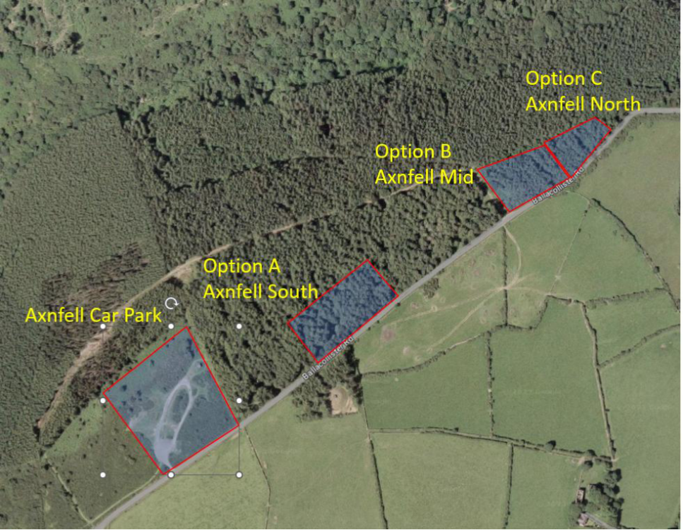
1.4.1. Landowner negotiations were initiated for the preferred site options. However, these negotiations stalled for various reasons. Subsequently, the Treasury approached Manx Utilities with a number of potential alternative sites within the Axnfell Plantation.
1.4.2. The benefit of these sites was that the Isle of Man Government owned them, and they were prepared sell the land to the Applicant for a nominal sum. DEFA undertook an initial environmental assessment of these available sites, as illustrated in Figure 1 below, and assessed that Option C, Axnfell North was the most suitable site for development, which had the least environmental impact. The main reason being that the identified area of the plantation had predominantly low value tree species and was programmed for harvesting at some time in the future.
4 The optioneering sites at paragraph 1.3.1 have been anonymised throughout for privacy reasons.
Figure 1 Axnfell Plantation Options Plan
1.4.3. The qualitative fine screening assessment and high-level costing of the shortlisted sites were then updated to include the Axnfell Plantation option for comparison. The results are summarised the table below:
Table 7 Fine Screening Revised Top Five Selection List
Rank Site Name Score
1 Option 2 – Site 2 26%
2 Option 3 – Site 3 24%
3 Option 1 – Site 1 23%
4 Option 7 – Axnfell Plantation (North – Option C) 21%
5 Option 4 – Site 4 18%
An aerial site location map showing three potential development options outlined in red near Ballacollister Road and Axnfell Car Park.
1.4.4. The revised qualitative fine screening assessment presented in Table 7 (based upon Site 1 and Site 2 being discounted) ranks the Site 3 option second, with the Axnfell Plantation option ranking next.
1.4.5. However, when considering in combination the Quantitative and Qualitative elements, Manx Utilities concluded that Axnfell North represented the preferred available option.
Table 8 Option Progression Order
Progression Order<br><br>1st<br><br>
Option<br><br>Option 1 – Site 1 (Not Progressed)
2nd
Option 2 – Site 2 (Not Progressed)
3rd
Option 7 – Axnfell Plantation North
4th
Option 3 – Site 3
5th
Option 4 – Site 4
6th
Option 5 – Site 5
7th
Option 6 – Pump Away Option
Arcadis Consulting (UK) Limited Suite 4D, Fourth Floor Hodge House 114-116 St Mary Street Cardiff CF10 1DY T: +44 (0)29 2092 6700
arcadis.com
Copyright in submitted documents remains with their authors. Request removal
Source & Provenance
Official reference
25/90738/B
Source authority
Isle of Man Government Planning & Building Control