Planning Statement In Support Of The Conversion Of Existing Barn To Residential Accommodation (Class 3.3), The Grange, Clypse Moar Road, Onchan Im4 5Bg.
A photograph showing a large, weathered stone outbuilding with a corrugated roof and dark openings, set in a gravel yard.
1.0 INTRODUCTION
1.1 The site is part of the holding associated with The Grange, a residential dwelling with a number of outbuildings, all situated to the north of Little Mill Road and to the west of Clypse Reservoir. Access to The Grange and its outbuildings is the public highway which provides access to the Clypse and Kerrowdhoo Reservoirs as well as a small number of dwellings Clypse Cottages, Clypse Lodge, Clypse Moar Farm, Clypse Reservoir House, the Grange gatehouse as well as The Grange itself.
1.2 As well as The Grange, the holding accommodates the gatehouse, a small stone two storey outbuilding alongside the house, a garage building which sits to the north west of the main house, a barn which sits at right angles to the garage and another barn to the rear of that. Behind this group of buildings is another, detached barn together with single storey stone animal outbuilding to the west.
1.3 The holding now extends to approximately 2.9 ha (7 acres) although formerly was larger.
2.0 PLANNING POLICY
2.1 Area Plan for the East (2020)
2.2.1 The site lies within an area designated on the Area Plan for the East as not for a particular purpose.
2.2.2 The Environmental Constraints map which accompanies the Area Plan does not identify any constraints applying to any of the land or buildings owned in association with The Grange.
2.2.3 On the Infrastructure Constraints map, the site lies within an area considered to be “Unsuitable for development, danger of pollution to water supply” due to its proximity to the two adjacent reservoirs.
2.2.4 The Area Plan adopts the findings and recommendations of the Landscape Character Assessment which designates the site as Incised Inland Slopes - D3 - Conrhenny and Groudle where it states the following:
Landscape Strategy Conserve and enhance:
a) the character, quality and distinctiveness of this area of relatively sparse settlement;
b) its valley bottom woodland;
c) its National Glens; d) the various archaeological features within the area.
Key Views Dramatic views to an Upland backdrop to the North and West. Dramatic, panoramic views eastwards across the ever-changing colour and nature of the sea and sky, contribute to strongly recognisable sense of place.
Close and distant views to the northern edge of Onchan/ Douglas settlement, which is visually harsh in places.
Channelled views along the corridor of the Groudle River, which is enclosed in places.
2.2 Isle of Man Strategic Plan 2016
2.2.1 The Strategic Plan sets out largely non geographic policies which apply to development on the Island. Where land is not designated for a particular purpose, there is a presumption against development unless it falls within one of the exceptions listed in General Policy 3. This includes:
(b) conversion of redundant rural buildings which are of architectural, historic, or social value and interest; (Housing Policy 11).
2.2.2 Housing Policy 11 and Environment Policy 16 provide further advice on such development:
Environment Policy 16:
The use of existing rural buildings for new purposes such as tourist, or smallscale industrial/commercial use may be permitted where:
a) it is demonstrated that the building is no longer required for its original purpose and where the building is substantially intact and structurally capable of renovation;
b) the reuse of the building will result in the preservation of fabric which is of historic, architectural, or social interest or is otherwise of visual attraction;
c) it is demonstrated that the building could accommodate the new use without requiring extension or adverse change to appearance or character;
d) there would not be unacceptable implications in terms of traffic generation;
e) conversion does not lead to dispersal of activity on such a scale as to prejudice the vitality and viability of existing town and village services; and
f) the use of existing buildings involves significant levels of redevelopment to accommodate the new use, the benefits secured by the proposal in terms of impact on the environment and the rural economy shall outweigh the continued impact of retaining the existing buildings on site. Proposals to convert rural
buildings to residential accommodation will be considered along with the advice given at Section 8.10 of this document.
Housing Policy 11:
Conversion of existing rural buildings into dwellings may be permitted, but only where:
(a) redundancy for the original use can be established;
(b) the building is substantially intact and structurally capable of renovation;
(c) the building is of architectural, historic, or social interest;
(d) the building is large enough to form a satisfactory dwelling, either as it stands or with modest, subordinate extension which does not affect adversely the character or interest of the building;
(e) residential use would not be incompatible with adjoining established uses or, where appropriate, land-use zonings on the area plan; and
(f) the building is or can be provided with satisfactory services without unreasonable public expenditure.
Such conversion must:
(a) where practicable and desirable, re-establish the original appearance of the building; and
(b) use the same materials as those in the existing building. Permission will not be given for the rebuilding of ruins or the erection of replacement buildings of similar, or even identical, form.
Further extension of converted rural buildings will not usually be permitted, since this would lead to loss or reduction of the original interest and character.
Both policies contain similar provisions with generally similar criteria. Whilst not defined within these policies, Housing Policy 13, which provides guidance on the renovation of dwellings which have lost their habitable status by abandonment, states that “substantially intact” involves “there being at least three of the walls, standing up to eaves level and structurally capable of being retained”.
2.2.3 Development which is harmful to the countryside is presumed against (Environment Policy 1).
2.2.4 On the Isle of Man Planning Scheme (Development Plan) Order 1982 the site does not lie within an area of an area of High Landscape or Coastal Value and Scenic Significance. As such, Environment Policy 2 is not applicable to this development.
2.2.5 Development is generally directed towards sustainable locations and to existing settlements (Strategic Policies 1, 2 and 10, Spatial Policy 5, Housing Policy 4 and Transport Policy 1).
2.2.6 Development which would be harmful to ecology is presumed against (Environment Policy 4).
2.2.7 In pre 1920 buildings the use of traditional materials is preferred (Environment Policy 34).
2.2.8 The loss of agriculturally productive land is presumed against: this is considered to be Classes 3/2 and 2/3 and above. The site lies within an area of Class 3 soil quality.
2.3 Landscape Character Assessment (2008)
2.3.1 This was an exercise commissioned by the Department to supersede the 1982 Areas of an area of High Landscape or Coastal Value and Scenic Significance. The Assessment subdivides the Island into a series of landscape Character Types and with a range of guidance on how to protect the various elements identified as important within them. The full assessment as it applies to this site is set out in Appendix One.
2.3.2 The conclusion of this landscape character area is:
The overall strategy is to conserve and enhance the character, quality and distinctiveness of this area of relatively sparse settlement, its valley bottom woodland, its National Glens and the various archaeological features within the area.
3.0 THE PROPOSAL
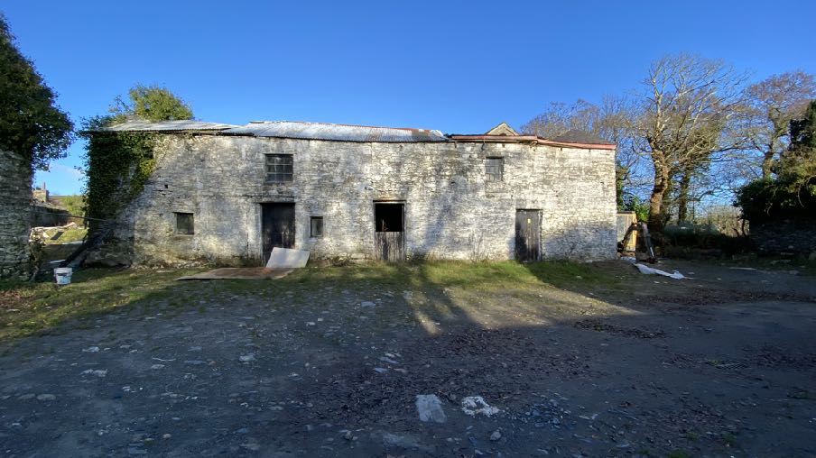
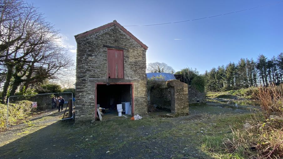
3.1 Proposed is the conversion of the barn immediately to the rear of The Grange to living accommodation.
3.2 The barn currently appears thus:
Eastern elevation
Southern elevation
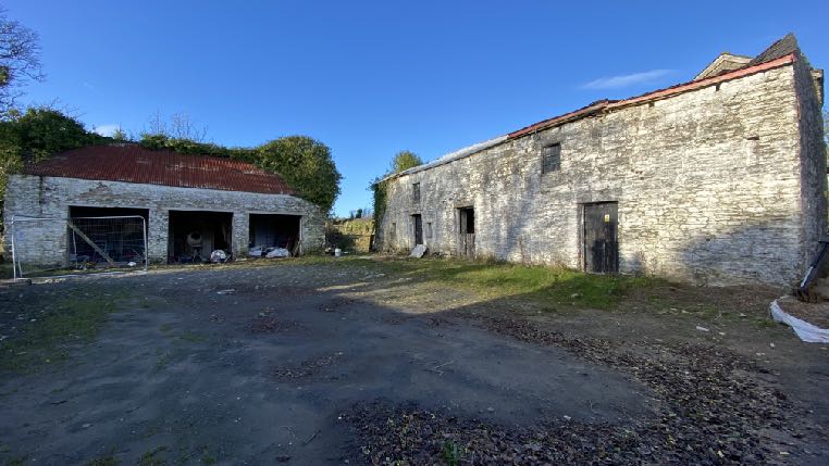
Exterior photograph of a large, weathered stone outbuilding or barn with multiple windows and a pitched roof, showing signs of age and disrepair.A photograph showing a rural site with two stone outbuildings and a gravel yard. The larger building on the right appears to be a barn, while the smaller structure on the left has open bays.
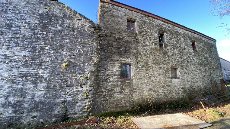
Northern elevations
3.3 The stone building has a mix of slate and sheeted roofing with most of the walls intact. There is variety of window openings with the main section having no openings in the rear
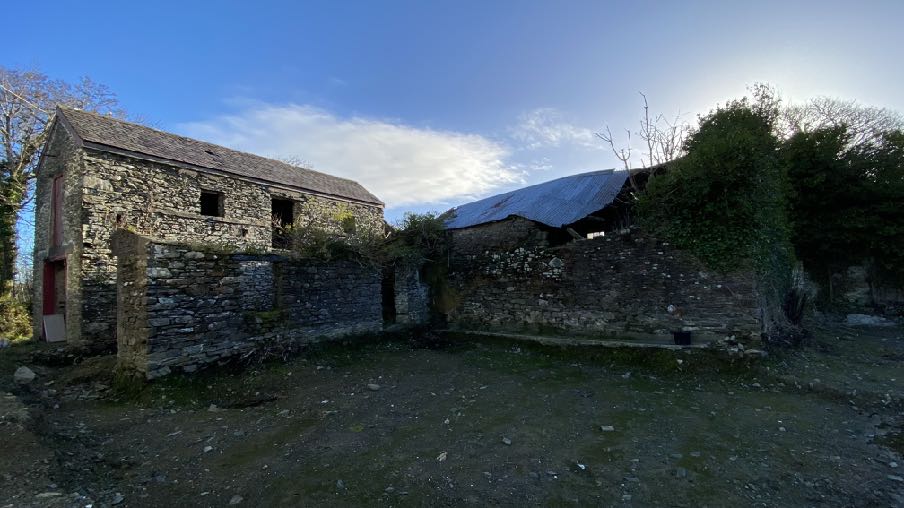
A photograph showing a rural site with a two-story stone outbuilding and a lower ruined wall structure.A photograph showing a stone outbuilding or barn with a large ground-floor opening and a smaller upper door, situated in a rural setting with people standing near a temporary fence.
and doors and windows in the front (south) elevation. The detached garage has three garage door openings facing east onto the yard to the rear of The Grange.
3.4 Proposed is the renovation of both buildings, the linking of the two and the creation of a four bedroomed dwelling therefrom.
3.5 It is proposed to slightly extend the rear section of the building by way of a lean to single storey stone addition on the footprint of existing walling as may be seen in the last photograph above. Five Conservation style roof lights will be installed in this new, longer roof plane. A new window will be installed in the rear (north) elevation at first floor level and bifold doors below. Four new Conservation style roof lights will be introduced on the rear pitch.
3.6 On the principal (southern) elevation, The majority of the front wall will be rebuilt. A new small window will be introduced on the ground floor with a widening of the existing central doorway but other openings at ground floor level to remain as existing. On the first floor, one existing window opening is to remain as existing with the other two openings enlarged slightly and three further windows added. The roof will be reconstructed and an array of solar panels added.
3.7 Patio doors will be provided to the existing garage door openings. Whilst it would be desirable to retain the garaging, the internal depth is only 4.2m and insufficient to accommodate a full sized car and as such, new garaging is proposed across the courtyard. The former garage roof will have three roof lights installed in both pitches.
3.8 The link section will be a simple rendered, single storey annex which provides a porch leading internally to both adjacent structures which are both part of the proposed single dwelling.
3.9 The existing openings in the eastern elevation of the barn are largely to be retained with slight enlargement.
3.10 All roofing is to be in slate with no change to the eaves or ridge heights or the pitches of the roofs. The window frames and doors will be dark grey coloured.
3.11 The new garaging will take the form of a double garage with an external footprint of 6.6m by 6.5m with a single garage door and roof pitched and finished to match the existing buildings with which it would be associated. Two further parking spaces are proposed alongside.
3.12 The residential curtilage associated with the new dwelling is to incorporate the courtyard in front of the buildings along with an area of garden to the west, extending down to the side of The Grange. The lower part of field 534630 will be part of the land associated with unit 2 and may be used for agricultural (grazing of animals) or horticultural purposes (growing fruit and/ or vegetables).
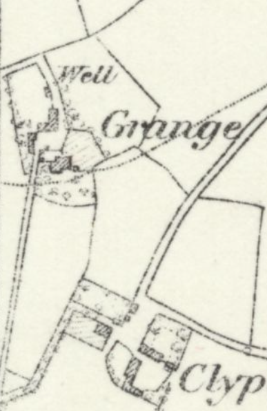
3.13 The buildings are shown, or structures in their place, on the 1860s County Series maps:
A black and white historical site map or plan showing property boundaries, building footprints, and labels such as 'Well Grange'.
3.14 The applicant has had a survey of the buildings undertaken for the presence or potential presence of birds. Manx Birdlife undertook the survey in February 2025 and considered the existing garage, the L shaped stone buildings and the more modern building to the north, separately.
3.15 The garage showed no evidence of breeding birds but there was evidence of roosting birds in the stone outbuilding and an old robin’s nest, likely from the previous year, was found in a cavity in one of the walls of the adjoining building. Robins are considered to be of least conservation concern but nevertheless are protected if nesting or breeding.
3.16 The report confirms no records of breeding birds within 100m of the property and with the buffer extended to 250m there was one record of breeding robin. As the survey was carried out side of the breeding season, it was unlikely that any active nests would have been found. Any evidence found would have been from the 2024 breeding season. It was not possible to search the areas of ivy on each of the buildings for presence of nests. It was not possible to access all areas of building 2 and building 4 due to health and safety reasons. There was no access to building 3 so it was not possible to survey the interior of the building.
3.17 The recommendation of the report is as follows:
The buildings and trees surveyed do have potential for breeding and roosting birds, primarily within the stone walls and areas of ivy but given the limited evidence found, any redevelopment of the buildings would have a negligible impact on the availability of suitable nesting sites for breeding birds. Any impact, however small can easily be mitigated for by the installation of nest boxes and by ensuring all works timed to be carried out outside the breeding season.
•Any work on the property should be carried out outside of the breeding bird season (generally late March to early August).
•As much of the existing ivy coverage as possible should be maintained throughout the property whether on buildings or on trees for the habitat benefits it provides.
•A site inspection should be carried out prior to clearing any areas of ivy on the buildings or trees for species such as wood pigeon which are known to breed throughout the year.
•Nest boxes should be installed to mitigate for the loss of any potential nest sites. Nest boxes can be installed at any time during the year but the autumn months are optimal.
•Additional nest boxes for species such as Swift (Red listed on the Birds of Conservation Concern in the Isle of Man (BoCCIoM), 2021 and are therefore considered to be of greatest conservation concern) could also be incorporated into the redevelopment using swift bricks or external nest boxes. (See below for species specific recommendations).
•Additional steps could be taken on the wider property to provide suitable nesting habitat for birds such as nesting boxes in surrounding trees. (See below for species specific recommendations) or the provision of further areas of scrubby cover.
•Specific species referred to above are swallows, swifts, robins, wrens, and house sparrows.
3.17 The development will incorporate the recommendations of the PEAR and will include bird and bat habitat as shown in the submitted drawings.
3.18 A Structural Engineer’s Report is included, prepared by BSA and dated 07.04.25. It states that the roofs of both outbuildings to be uneven and distorted with part of the higher section on barn 2 to have its roof collapsed or partially collapsed. The walls all showed cracking, distortion and loose mortar. The report states that it is highly unlikely that the buildings have concrete foundations with any support probably to have been corbelled stone. New concrete ground floor slabs with thickened out edges, against the internal perimeter walls of the buildings should be provided to receive a new concrete block load bearing lining wall, which in turn would take the loadings of the proposed replacement upper floors and replacement/upgraded roof structures. This would lesson any additional loadings being transmitted onto the existing stone foundation of the external walls.
3.19 It recommends that the front wall of the southern barn should be carefully demolished due to its condition and rebuilt on a new concrete strip foundation, carried out in small sections at a time with the existing adjacent stone walls ecru rely propped up to prevent fall.
All roofing is to be replaced in accordance with Building Regulations. The other barn is considered to be more stable and no wall rebuilding is required.
4.0 ASSESSMENT
4.1 There is a provision for the creation of new dwellings through the conversion of existing buildings of interest (General Policy 3 and Housing Policy 11) subject to certain criteria.
(a) redundancy for the original use can be established;
(b) the building is substantially intact and structurally capable of renovation;
(c) the building is of architectural, historic, or social interest;
(d) the building is large enough to form a satisfactory dwelling, either as it stands or with modest, subordinate extension which does not affect adversely the character or interest of the building;
(e) residential use would not be incompatible with adjoining established uses or, where appropriate, land-use zonings on the area plan; and
(f) the building is or can be provided with satisfactory services without unreasonable public expenditure.
Such conversion must:
(a) where practicable and desirable, re-establish the original appearance of the building; and
(b) use the same materials as those in the existing building. Permission will not be given for the rebuilding of ruins or the erection of replacement buildings of similar, or even identical, form.
Further extension of converted rural buildings will not usually be permitted, since this would lead to loss or reduction of the original interest and character.
4.2 Redundancy for the original use can be established
4.2.1 The building is presently partly used for storage although a part of the building is currently unsafe for access due to its structural condition (see below). The garage building whilst having garage door openings, has an internal length of 4.2m which is short of current
requirements for accommodating a modern car and much less than is required for most modern farming machinery.
4.2.2 The main building has two storeys of accommodation and generally small openings which does not facilitate use by modern agricultural machinery. Furthermore, the majority of the openings of all the buildings are into the courtyard to the rear of the main house necessitating any vehicles or movements associated with the buildings to come via the shared access and to be in close proximity to the dwelling. The recently approved application for the detached garage and access to the south of the house (23/01349/B demonstrates the desire to separate the traffic and functions of these buildings from those of the main house. There is also limited manoeuvring space for large vehicles or animals in this existing farmyard.
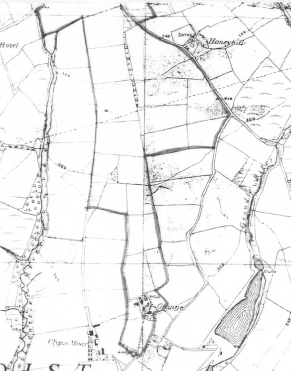
4.2.3 As such, the continued use of these buildings for agriculture is very much constrained by their location, orientation and design. Furthermore, it is clear from looking at previous applications for the site when it was a working farm, that the land holding was formerly considerably larger than it now is. This map is taken from the 1986 application for alterations to the house (86/01262/B).
4.2.4 It demonstrates that the farm holding formerly stretched to the Creg ny Baa backroad and accommodated over 100 acres compared with the holding of 7 acres.
4.2.5 It is submitted that the buildings are no longer suitable for their originally intended use for agriculture and that they are redundant for those purposes. 4.3 The building is substantially intact and structurally capable of renovation;
4.3.1 A Structural Engineer’s report is provided which demonstrates that the building is mostly structurally capable of retention and conversion but with the rebuilding of the southern elevation. This retains the majority of the walls and is thus compliant with this section of the policy. It is noted that in a similar policy for renovation of existing rural former dwellings, “structurally intact” is defined as “this will involve there being at least three of the walls, standing up to eaves level and structurally capable of being retained”. In this case the existing building is completely intact with only one wall requiring to be carefully replaced.
4.4 The building is of architectural, historic, or social interest;
4.4.1 The 1860s maps show buildings on the site roughly in the form that they appear today. Whilst the building with the garage doors has clearly been altered over time, they retain the existing building footprint and the main building is largely unaltered.
4.4.2 Traditional farm groups are becoming more scarce as modern agricultural practices move away from buildings of such narrow depth and with such small openings. In many cases such farm groups have been supplemented by newer, larger span buildings and in some cases the old and new may sit alongside each other and still function as an agricultural group but in others, the layout of the farm is such that the older buildings are no longer suitable, as is the case here. There were relatively few additional buildings added to the building group - the piggery building to the west which is in such poor condition that it is not to be retained, and the more modern building to the north. As such, the building group remains largely as it formerly did.
4.4.3 In the interests of preserving historic agricultural practices and traditional farmsteads, we would submit that the age of these buildings and their relatively unaltered appearance makes them eligible for conversion under Housing Policy 11(c).
4.5 The building is large enough to form a satisfactory dwelling, either as it stands or with modest, subordinate extension which does not affect adversely the character or interest of the building;
4.5.1 The submitted drawings demonstrate that the buildings may be converted with minimal change to become an attractive unit of residential accommodation. There are
minimal new windows or changes to existing openings and most openings are being retained as is. The three existing garage doors are to remain and be glazed and there will be a modest, simple, single storey link added to join the existing garage building to the main barn.
4.5.2 There will be a very modest extension which utilises existing walling at the rear of the building and we consider that the buildings are large enough to satisfactorily form a dwelling unit and that the proposed additions are modest and subordinate in line with the policy.
4.6 Residential use would not be incompatible with adjoining established uses or, where appropriate, land-use zonings on the area plan; and
4.6.1 As explained above, the proximity of the barns to the house would result in agricultural activity being close to and sharing much of the same access as the house and as such, the conversion of these buildings to a single residential unit would result in a more compatible use next to the main house. Traffic would involve smaller, quieter vehicles and more sociable times of day and with less potential mess and smell than if they were used for agriculture or equestrian purposes.
4.6.2 Whilst residential use and development is generally presumed against in such areas of the countryside Housing Policy 11 and General Policy 3 both clearly make provision for the creation of a residential unit through the conversion of existing buildings.
4.6.3 We would therefore submit that the proposed use is compatible with the existing adjoining land uses and the designation of the site in compliance with the policy.
4.6.4 The retention of part of field 534630 with this property provides a useful area of space for the occupants of the application property to use either for the keeping of animals or the growing of fruit and vegetables whilst retaining an appropriate and proportionate area of domestic garden to the west. There is the potential also for field 5342653 to be available to the owner of either unit to add to the agricultural land, should additional land be needed for grazing or planting.
4.7 The building is or can be provided with satisfactory services without unreasonable public expenditure.
4.7.1 There is existing electricity, water, drainage and telephone services available to the buildings.
4.8 Such conversion must:
(a) where practicable and desirable, re-establish the original appearance of the building; and
4.8.1 The proposed conversion works change the building very slightly and do not affect its mass, siting or character. The building will appear as a converted barn without any domestic porches, conservatories or other features. The conversion therefore largely retains the original appearance of the buildings.
(b) use the same materials as those in the existing building. Permission will not be given for the rebuilding of ruins or the erection of replacement buildings of similar, or even identical, form.
4.8.2 The conversion will involve the introduction of rendered walling in the link section which whilst contrasting to the adjacent stone buildings which differentiate between the original and new fabric - a form of conversion often accepted by the Department. Otherwise the materials to be used - stone and slate will replicate the original materials on the building and the windows and doors will be framed in a dark grey colour.
4.9 Conclusion
4.9.1 The application building is part of a group of structures which formerly provided a base for a larger agricultural holding which is no longer associated with the group. The buildings are redundant for their original purposes but still capable of being used for other purposes. The condition of this building is such than unless a new purpose is found for it, it is unlikely to be maintained and will eventually fall into further disrepair and become dangerous and potentially be demolished.
4.9.2 Much of the building group - in this case the principal building - is of some age and as such, of historical interest and we believe it is appropriate to try to retain the group as is and find a new use for it. Whilst the existing garage is a more modern structure, it sits upon the footprint of a former building which is shown on the 1860s maps and formed part of the character of the group. What is proposed will retain this character.
4.9.3 There is existing access to the site which will be retained.
4.9.4 The proposed development would introduce new opportunities for wildlife habitat and will ensure the management and use of the site which is presently unused and contributes little to the surrounding area or environment.
4.9.5 We believe that the proposal meets the requirements of all of the relevant planning policies and will result in the retention of an important part of Onchan’s farming history whilst creating an opportunity for an interesting and comfortable rural dwelling to be created with no adverse environmental impact.
Sarah Corlett 25.05.25
APPENDIX ONE
EXCERPT FROM THE LANDSCAPE CHARACTER ASSESSMENT (2008) D3 CONRHENNY/GROUDLE Key Characteristics
• Gently rolling topography, which is cut by a series of rivers.
• Contain the relatively narrow corridors of the Groudle and Ballacottier Rivers.
• Patchwork of organised pasture and arable fields delineated by a combination of hedgerows, Manx banks and visible drainage ditches.
• Patches of regular coniferous woodland plantations as visible landmarks with the surrounding landscape.
• Distinctive black and white Manx milestones lining the A2 road corridor.
• Series of scattered, isolated farmsteads (several of which have associated modern farm buildings).
• Sense of enclosure provided by Uplands to the north-west.
• Open views to visually harsh red roofs of modern housing developments at the edge of Onchan dominate views southwards.
• Dramatic, panoramic views eastwards across the ever-changing colour and nature of the sea and sky, contribute to strongly recognisable sense of place.
Overall Character Description This character area encompasses gently rolling topography, which is cut by a series of small rivers and streams, including Groudle River and Ballacottier River, which flow north-south across the area. To the north of Onchan, the Groudle River has been dammed to form two triangular reservoirs, Kerrowdhoo and Clypse, which are visible on the horizon on approach to the area. Landscape within the area is covered by a patchwork of organised pasture and arable fields, which are delineated by a combination of hedgerows and Manx banks. Ditches are also characteristically visible at field boundaries in certain locations.
Three regular-shaped coniferous woodland plantations are situated on sloping land to the northeast of Onchan and provide recognisable sense of place. Set against a dramatic upland backdrop, these woodlands create a sense of enclosure surrounding Conrhenny equestrian centre and provide recognisable landscape features within an otherwise predominantly open landscape. To the south, the area is served by the main A2 road, which runs along the
coastline and connects Douglas in the south to Laxey in the north. A series of relatively quiet, rural roads lead northwards from this main road corridor, towards the upland backdrop.
Settlement pattern consists of a series of scattered, isolated farmsteads, several of which have visually intrusive modern farm buildings in proximity to the older, traditional farmhouses. A sense of enclosure is provided by Uplands to the northwest. Overall, there is a relatively strong sense of tranquillity throughout the character area, at distance from major roads corridors and the edges of Onchan.
To the north of Onchan, the geometric course of the A18 (TT course), with several viewing platforms and Marshals’ boxes, provides a recognisable transport corridor within the area. The sense of tranquillity is greatly disturbed during TT season. The meandering path of the Groudle River (which is enclosed and wooded in places) abuts the north-eastern edge of Onchan and flows eastwards to join the sea at Port Groudle. Just to the south of this river corridor, King Edward Bay golf course (situated on a prominent hill, and consisting of several areas of rough grassland and heathland) provides a distinct and recognisable landscape feature. In several places, open views to visually harsh red roofs of modern housing developments at the edge of Onchan dominate views southwards. Dramatic, panoramic views eastwards across the ever-changing colour and nature of the sea and sky, contribute to a strongly recognisable sense of place.
Key Views
• Dramatic views to an Upland backdrop to the north and west.
• Dramatic, panoramic views eastwards across the ever-changing colour and nature of the sea and sky, contribute to strongly recognisable sense of place.
• Close and distant views to the northern edge of Onchan/ Douglas settlement, which is visually harsh in places.
• Channelled views along the corridor of the Groundle River, which is enclosed in places.
Historic Features
• St. Adamnan’s/Lonan Old Church
• Standing stones and tumuli
Ecological Features
• Biodiversity value within regular patches of predominantly coniferous woodland.
• Stream corridors.
• Intact network of mature hedgerows.
Evaluation of Inherent Landscape Sensitivities
• Fragmented woodland in valley bottoms.
• Rivers and reservoirs with riparian habitats.
• Scattered settlement pattern of isolated farms and hamlets.
• Sites of archaeological importance.
• Manx Milestones by roadside.
• Well-vegetated character alongside A-roads.
• Victorian Isle of Man Steam Railway and station.
Landscape Strategy The overall strategy is to conserve and enhance the character, quality and distinctiveness of this area of relatively sparse settlement, its valley bottom woodland, its National Glens and the various archaeological features within the area.
Copyright in submitted documents remains with their authors. Request removal
Source & Provenance
Official reference
25/90528/B
Source authority
Isle of Man Government Planning & Building Control