Planning Statement In Support Of The Conversion Of Existing Outbuilding To Residential Accommodation (Class 3.3), The Grange, Clypse Moar Road, Onchan Im4 5Bg.
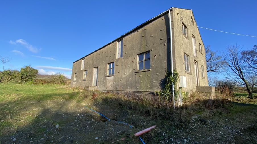
A photograph showing a large, grey concrete outbuilding or agricultural structure situated in a grassy field under a clear blue sky.
1.0 INTRODUCTION
1.1 The site is part of the holding associated with The Grange, a residential dwelling with a number of outbuildings, all situated to the north of Little Mill Road and to the west of Clypse Reservoir.
1.2 Access to The Grange and its outbuildings is the public highway which provides access to the Clypse and Kerrowdhoo Reservoirs as well as a small number of dwellings - Clypse Cottages, Clypse Lodge, Clypse Moar Farm, Clypse Reservoir House, the Grange gatehouse
as well as The Grange itself.
1.3 As well as The Grange, the holding accommodates the gatehouse, a small stone two storey outbuilding alongside the house, a garage building which sits to the north west of the main house, a barn which sits at right angles to the garage and another barn to the rear of that. Behind this group of buildings is another, detached barn together with single storey stone animal outbuilding to the west.
1.4 The holding now extends to approximately 2.9ha (7 acres) although formerly was larger.
2.0 PLANNING POLICY
2.1 Area Plan for the East (2020)
2.2.1 The site lies within an area designated on the Area Plan for the East as not for a particular purpose.
2.2.2 The Environmental Constraints map which accompanies the Area Plan does not identify any constraints applying to any of the land or buildings owned in association with The Grange.
2.2.3 On the Infrastructure Constraints map, the site lies within an area considered to be “Unsuitable for development, danger of pollution to water supply” due to its proximity to the two adjacent reservoirs.
2.2.4 The Area Plan adopts the findings and recommendations of the Landscape Character Assessment which designates the site as Incised Inland Slopes - D3 - Conrhenny and Groudle where it states the following:
Landscape Strategy Conserve and enhance:
a) the character, quality and distinctiveness of this area of relatively sparse settlement;
b) its valley bottom woodland;
c) its National Glens; d) the various archaeological features within the area.
Key Views Dramatic views to an Upland backdrop to the North and West. Dramatic, panoramic views eastwards across the ever-changing colour and nature of the sea and sky, contribute to strongly recognisable sense of place.
Close and distant views to the northern edge of Onchan/ Douglas settlement, which is visually harsh in places.
Channelled views along the corridor of the Groudle River, which is enclosed in places.
2.2 Isle of Man Strategic Plan 2016
2.2.1 The Strategic Plan sets out largely non geographic policies which apply to development on the Island. Where land is not designated for a particular purpose, there is a presumption against development unless it falls within one of the exceptions listed in General Policy 3. This includes:
(b) conversion of redundant rural buildings which are of architectural, historic, or social value and interest; (Housing Policy 11).
2.2.2 Housing Policy 11 provides further advice on such development:
Housing Policy 11:
Conversion of existing rural buildings into dwellings may be permitted, but only where:
(a) redundancy for the original use can be established;
(b) the building is substantially intact and structurally capable of renovation;
(c) the building is of architectural, historic, or social interest;
(d) the building is large enough to form a satisfactory dwelling, either as it stands or with modest, subordinate extension which does not affect adversely the character or interest of the building;
(e) residential use would not be incompatible with adjoining established uses or, where appropriate, land-use zonings on the area plan; and
(f) the building is or can be provided with satisfactory services without unreasonable public expenditure.
Such conversion must:
(a) where practicable and desirable, re-establish the original appearance of the building; and
(b) use the same materials as those in the existing building. Permission will not be given for the rebuilding of ruins or the erection of replacement buildings of similar, or even identical, form.
Further extension of converted rural buildings will not usually be permitted, since this would lead to loss or reduction of the original interest and character.
Whilst not defined within these policies, Housing Policy 13, which provides guidance on the renovation of dwellings which have lost their habitable status by abandonment, states that “substantially intact” involves “there being at least three of the walls, standing up to eaves level and structurally capable of being retained”.
2.2.3 Development which is harmful to the countryside is presumed against (Environment Policy 1).
2.2.4 On the Isle of Man Planning Scheme (Development Plan) Order 1982 the site does not lie within an area of an area of High Landscape or Coastal Value and Scenic Significance. As such, Environment Policy 2 is not applicable to this development.
2.2.5 Development is generally directed towards sustainable locations and to existing settlements (Strategic Policies 1, 2 and 10, Spatial Policy 5, Housing Policy 4 and Transport Policy 1).
2.2.6 Development which would be harmful to ecology is presumed against (Environment Policy 4).
2.2.7 In pre 1920 buildings the use of traditional materials is preferred (Environment Policy 34).
2.2.8 The loss of agriculturally productive land is presumed against: this is considered to be Classes 3/2 and 2/3 and above. The site lies within an area of Class 3 soil quality.
2.3 Landscape Character Assessment (2008)
2.3.1 This was an exercise commissioned by the Department to supersede the 1982 Areas of High Landscape or Coastal Value and Scenic Significance. The Assessment subdivides the Island into a series of landscape Character Types and with a range of guidance on how to
protect the various elements identified as important within them. The full assessment as it applies to this site is set out in Appendix One.
2.3.2 The conclusion of this landscape character area is:
The overall strategy is to conserve and enhance the character, quality and distinctiveness of this area of relatively sparse settlement, its valley bottom woodland, its National Glens and the various archaeological features within the area.
3.0 THE PROPOSAL
3.1 Proposed is the conversion of the outbuilding immediately to the rear of The Grange to living accommodation with additional use as tourist accommodation.
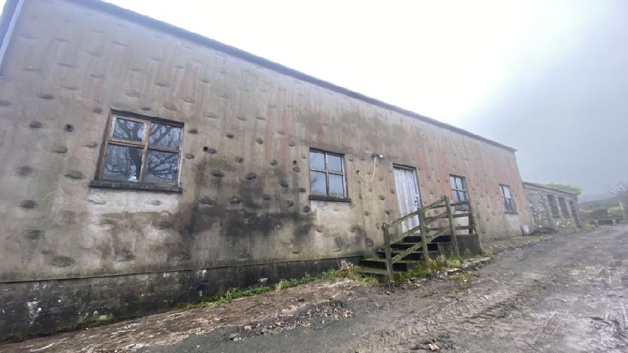
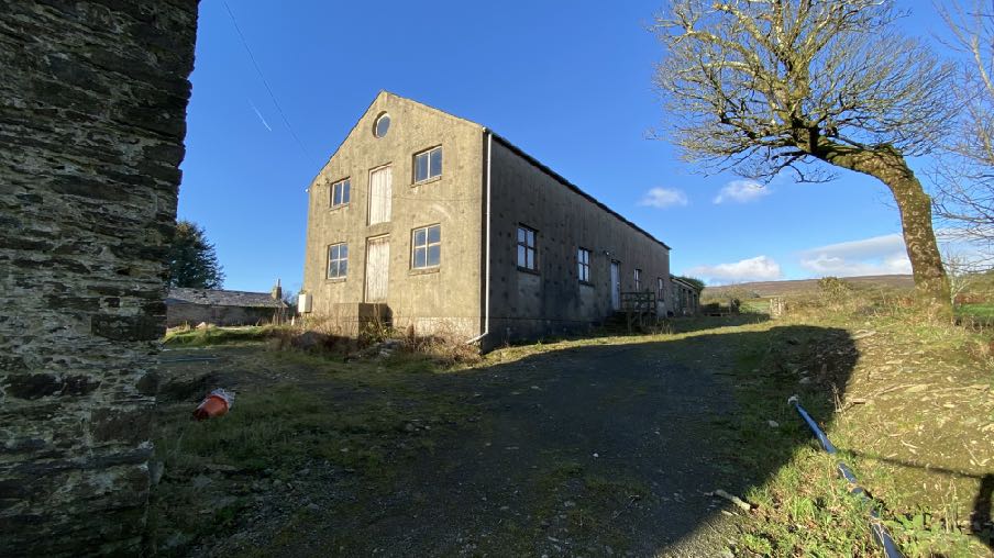
3.2 The barn currently appears thus:
Eastern elevation
A photograph showing the exterior of a long, single-story concrete outbuilding with a rough, pockmarked facade and wooden steps leading to a door.
Southern elevation
Western elevation
A photograph of a large, rectangular concrete outbuilding situated in a grassy rural field under a clear blue sky.A photograph showing a large, two-story concrete outbuilding with a gable end, situated in a rural setting with a gravel driveway leading up to it.
3.3 The building has no planning approval as far as we can ascertain although it is shown on a planning application dating from 1986 (86/01262/B). In addition, discussions with the Government Rating Officer confirm that a rating inspection in 1991 shows, in the officer’s report, a note that the building was in situ then. There are no discernible additions or alterations which have been undertaken in any recent times.
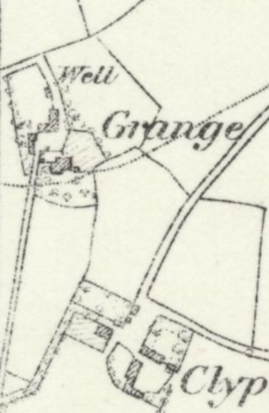
3.4 There is a small structure shown on the 1860s County Series maps in the location of this building although what currently exists is much larger. It is assumed that the small existing stone building is what is shown on this historic map.
A black and white historical map or site plan showing property boundaries, field divisions, and building outlines with labels such as 'Well Grange'.
3.5 Proposed is the conversion of the building to a four bedroomed dwelling and a triple garage is also proposed to the west of the building. A new access is proposed to the west of the existing building group, together with the demolition of existing single storey agricultural buildings:
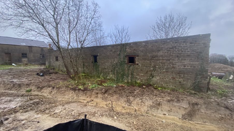
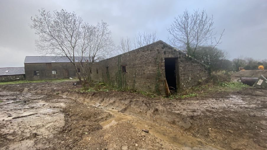
A photograph showing a long, single-story brick outbuilding with open apertures, situated on a site with disturbed earth and a new access path.A photograph showing a brick outbuilding situated in a muddy field with visible excavation work in the foreground and another building in the background.
3.6 No extensions are proposed to the building although a new small balcony with external steps is proposed to be added to the northern elevation of the two storey element. Two new first floor windows are to be added to the eastern elevation together with a full height glazed window where there is currently a door. A new door will be installed alongside and five conservation style rooflights added to the eastern roof plane. The door and windows in the stone section of the building will remain as they are.
3.7 A new stone entrance ramp will be added to the western elevation and a new window with Juliet style balcony added above the existing centrally positioned roof light. The ground floor windows will be retained and two further windows added to the first floor.
3.8 One existing window will be altered in the northern elevation and one window removed in the southern elevation.
3.9 The applicant would like to add interest to the building by adding stone cladding to the front elevation. It is felt that this also reflects the agricultural context of the building. If this is not felt appropriate, elevations are also included which show the existing render finish retained, as an alternative.
3.10 The residential curtilage associated with the new dwelling is to incorporate a small area to the east beyond which the field will be retained as a paddock and/or area for growing fruit and vegetables. It is not proposed to incorporate this into the residential curtilage.
3.11 The garden associated with this unit will be mostly to the west of the building with an area provided to accommodate vehicular parking including a triple garage incorporating the opportunity for EV charging (details provided) and three additional car parking spaces. This garage is roughly on the footprint of the existing animal outbuildings which are not structurally capable of being converted and are of limited height.
3.12 The garage will provide opportunities for the storage of equipment and vehicles potentially required for the maintenance of the garden and paddock although there is also adequate space for additional domestic structures to be constructed - for example sheds or greenhouses - under the provisions of the Town and Country Planning (Permitted Development) Order 2025 which could be accommodated without detriment to the neighbours’ amenities or the character or appearance of the site.
3.13 Given the amount of existing established planting, it is not proposed nor considered necessary to introduce any additional landscaping.
3.14 The applicant has had a survey of the buildings undertaken for the presence or potential presence of birds. Manx Birdlife undertook the survey in February 2025 and considered the existing garage, the L shaped stone buildings and the more modern building to the north, separately.
3.15 The report concludes that it was not possible to access the northernmost building and makes no comment about the suitability of this for bird habitat or presence.
3.16 The report confirms no records of breeding birds within 100m of the property and with the buffer extended to 250m there was one record of breeding robin. As the survey was carried out side of the breeding season, it was unlikely that any active nests would have been found. Any evidence found would have been from the 2024 breeding season. It was not possible to search the areas of ivy on each of the buildings for presence of nests. It was not possible to access all areas of building 2 and building 4 due to health and safety reasons. There was no access to building 3 so it was not possible to survey the interior of the building.
3.17 The recommendation of the report is as follows:
The buildings and trees surveyed do have potential for breeding and roosting birds, primarily within the stone walls and areas of ivy but given the limited evidence found, any redevelopment of the buildings would have a negligible impact on the availability of suitable nesting sites for breeding birds. Any impact, however small can easily be mitigated for by the installation of nest boxes and by ensuring all works timed to be carried out outside the breeding season.
•Any work on the property should be carried out outside of the breeding bird season (generally late March to early August).
•As much of the existing ivy coverage as possible should be maintained throughout the property whether on buildings or on trees for the habitat benefits it provides.
•A site inspection should be carried out prior to clearing any areas of ivy on the buildings or trees for species such as wood pigeon which are known to breed throughout the year.
•Nest boxes should be installed to mitigate for the loss of any potential nest sites. Nest boxes can be installed at any time during the year but the autumn months are optimal.
•Additional nest boxes for species such as Swift (Red listed on the Birds of Conservation Concern in the Isle of Man (BoCCIoM), 2021 and are therefore considered to be of greatest conservation concern) could also be incorporated into the redevelopment using swift bricks or external nest boxes. (See below for species specific recommendations).
•Additional steps could be taken on the wider property to provide suitable nesting habitat for birds such as nesting boxes in surrounding trees. (See below for species specific recommendations) or the provision of further areas of scrubby cover.
•Specific species referred to above are swallows, swifts, robins, wrens, and house sparrows.
3.18 The development will incorporate the recommendations of the PEAR and will include bird and bat habitat as shown in the submitted drawings.
3.19 A Structural Engineer’s Report is included which demonstrates that the building is structurally capable of the proposed conversion works. This report, prepared by BSA and dated 07.04.25, describes the building as approximately 40 years old and constructed from masonry other than the rear single storey section which is stone. Externally, the buildings show no indication of significant structural defects or spread, unevenness to the ridge or major deflection to the main roof slopes. Other than hairline cracks within the render, the taller section of the building is in good condition. The stone section shows more cracking.
3.20 The report concludes that the buildings are in fair condition and would lend themselves to conversion and alteration to residential or holiday accommodation which would necessitate the upgrading of insulation and re-roofing.
4.0 ASSESSMENT
4.1 There is a provision for the creation of new dwellings through the conversion of existing buildings of interest (General Policy 3 and Housing Policy 11) subject to certain criteria.
(a) redundancy for the original use can be established;
(b) the building is substantially intact and structurally capable of renovation;
(c) the building is of architectural, historic, or social interest;
(d) the building is large enough to form a satisfactory dwelling, either as it stands or with modest, subordinate extension which does not affect adversely the character or interest of the building;
(e) residential use would not be incompatible with adjoining established uses or, where appropriate, land-use zonings on the area plan; and
(f) the building is or can be provided with satisfactory services without unreasonable public expenditure.
Such conversion must:
(a) where practicable and desirable, re-establish the original appearance of the building; and
(b) use the same materials as those in the existing building. Permission will not be given for the rebuilding of ruins or the erection of replacement buildings of similar, or even identical, form.
Further extension of converted rural buildings will not usually be permitted, since this would lead to loss or reduction of the original interest and character.
Redundancy
4.2 The building is presently empty and unused. It is not clear from the layout of the space and form of the building, what it was originally intended for. There are no openings suitable for agricultural implements or vehicles nor animals. There is also a first floor.
4.3 If the building had originally been used for agricultural purposes, the land which was then associated with it was substantially more than is the case now. The 7 acres of the holding is mostly occupied by buildings or residential curtilage with the fields spread around the buildings with no easy means of access between them as the existing buildings are in the way.
4.4 The building is sizeable and it is not believed that any use of it, given its size, would be capable of being considered ancillary to either of the adjacent buildings.
4.5 As such, we believe that the building is redundant for whatever its original use was and there is no evidence of the building having been used in recent times, for any purpose.
Substantially intact and structurally capable of renovation
4.6 The building is structurally sound and in remarkably good condition despite not having been used or maintained for some time. The accompanying Structural Engineer’s Report confirms not only that the building is sound but is also capable of conversion works to residential or holiday accommodation.
Architectural, historic or social interest
4.7 The building is clearly a later addition to the farm building group, having been in situ for
at least forty years although not appearing in its currently form on the 1860s mapping. It lacks the interest of the form and materials of the adjacent buildings but nevertheless exists although not publicly visible.
4.8 Whilst it is not our position that the whole building is of architectural, historic or social interest, the northern stone section is clearly older and retains its original appearance and we consider that this element is of sufficient interest to satisfy the requirements of the policy. This section is very modest and would not in itself be capable of forming a useful unit of accommodation. The conversion of the whole building would see this section retained largely as is and thus any historic element of the original building group would be retained.
The building is large enough to form a satisfactory dwelling, either as it stands or with modest, subordinate extension which does not affect adversely the character or interest of the building
4.9 Other than the small balcony and external stair, the building is not being extended.
Residential use would not be incompatible with adjoining established uses or, where appropriate, land-use zonings on the area plan
4.10 It is also proposed to convert the existing buildings to the south of this structure, to residential accommodation. If this is permitted and implemented, and even were it not, the application building sits separately to the other buildings to the south and is to be accessed separately. The layout of the site as shown protects the privacy and amenities of both The Grange and the potential residential unit immediately to the south with a new hedge introduced between the two existing outbuildings to demarcate the boundary between them and to provide acceptable levels of privacy for both units.
4.11 The retention of part of field 534630 provides a useful area of space for the occupants of the application property to use either for the keeping of animals or the growing of fruit and vegetables whilst retaining an appropriate and proportionate area of domestic garden to the west. There is the potential also for field 5342653 to be available to the owner of either unit to add to the agricultural land, should additional land be needed for grazing or planting.
The building is or can be provided with satisfactory services without unreasonable public expenditure
4.12 All of the development can be provided with all required services - which are currently available to The Grange and the adjacent residences.
Such conversion must: (a) where practicable and desirable, re-establish the original appearance of the building; and (b) use the same materials as those in the existing building. Permission will not be given for the rebuilding of ruins or the erection of replacement buildings of similar, or even identical, form
4.13 The proposal does not alter the existing building significantly and retains its existing character and appearance. No part of the building is proposed to be replaced and whilst the applicant would like to add stone cladding, which would change the appearance of the building, we consider this enhances its character but an option to retain the current render finish is also proposed for consideration.
Conclusion
4.14 The application building is part of a group of structures which formerly provided a base for a larger agricultural holding which is no longer associated with the group. The buildings are redundant for their original purposes but still capable of being used for other purposes.
4.15 Much of the building group is of some age and as such, of historical interest and we believe it is appropriate to try to retain the group as is and find a new use for it. The principal part of this building is certainly newer than its neighbours but an existing part of the building group affording a sizeable amount of floorspace.
4.16 Were this application to be refused, the building will remain as it is and is of a size as not to be capable of providing ancillary uses for any of the buildings to the south. Its design does not lend itself to agricultural use and as such it is difficult to see what else this building could be used for such that it does not fall into disrepair and adversely affect the amenities of the other buildings on the site.
4.17 If the original use of this building was not agricultural, it would represent previously developed land for which there is provision for redevelopment under General Policy 3c. The proposed redevelopment would reduce the impact on the wider environment through the introduction of darker cladding as proposed, but as the building is not publicly visible, what is proposed would certainly not increase the impact of the building.
4.18 The conversion of the building would result in it being thermally insulated and more energy efficient than it currently is and a properly maintained and renovated building will contribute more positively to the surrounding area than does or would a building which has no useful purpose and as such is not well maintained. General Policy 3c would permit the rebuilding of the current structure in a less impactful form however, as the building is structurally sound, we consider it preferable and more environmentally acceptable to reuse and repurpose it rather than completely replacing it.
4.19 There is existing access to the site and the proposed additional track to the west of the building group will also the northernmost unit to be converted to residential use without adversely affecting the privacy or amenities of those in The Grange or the second converted outbuilding, should that application also be permitted.
4.20 The proposed development would introduce new opportunities for wildlife habitat and will ensure the management and use of the site which is presently unused and contributes little to the surrounding area or environment.
4.21 Cumulatively we consider that the proposal will enhance the character and appearance of the building group, enabling historic fabric to be repurposed and new life found for this important building group within Onchan’s rural landscape and history.
Sarah Corlett 21.05.25
APPENDIX ONE
EXCERPT FROM THE LANDSCAPE CHARACTER ASSESSMENT (2008) D3 CONRHENNY/GROUDLE Key Characteristics
• Gently rolling topography, which is cut by a series of rivers.
• Contain the relatively narrow corridors of the Groudle and Ballacottier Rivers.
• Patchwork of organised pasture and arable fields delineated by a combination of hedgerows, Manx banks and visible drainage ditches.
• Patches of regular coniferous woodland plantations as visible landmarks with the surrounding landscape.
• Distinctive black and white Manx milestones lining the A2 road corridor.
• Series of scattered, isolated farmsteads (several of which have associated modern farm buildings).
• Sense of enclosure provided by Uplands to the north-west.
• Open views to visually harsh red roofs of modern housing developments at the edge of Onchan dominate views southwards.
• Dramatic, panoramic views eastwards across the ever-changing colour and nature of the sea and sky, contribute to strongly recognisable sense of place.
Overall Character Description This character area encompasses gently rolling topography, which is cut by a series of small rivers and streams, including Groudle River and Ballacottier River, which flow north-south across the area. To the north of Onchan, the Groudle River has been dammed to form two triangular reservoirs, Kerrowdhoo and Clypse, which are visible on the horizon on approach to the area. Landscape within the area is covered by a patchwork of organised pasture and arable fields, which are delineated by a combination of hedgerows and Manx banks. Ditches are also characteristically visible at field boundaries in certain locations.
Three regular-shaped coniferous woodland plantations are situated on sloping land to the northeast of Onchan and provide recognisable sense of place. Set against a dramatic upland backdrop, these woodlands create a sense of enclosure surrounding Conrhenny equestrian centre and provide recognisable landscape features within an otherwise predominantly open landscape. To the south, the area is served by the main A2 road, which runs along the
coastline and connects Douglas in the south to Laxey in the north. A series of relatively quiet, rural roads lead northwards from this main road corridor, towards the upland backdrop.
Settlement pattern consists of a series of scattered, isolated farmsteads, several of which have visually intrusive modern farm buildings in proximity to the older, traditional farmhouses. A sense of enclosure is provided by Uplands to the northwest. Overall, there is a relatively strong sense of tranquillity throughout the character area, at distance from major roads corridors and the edges of Onchan.
To the north of Onchan, the geometric course of the A18 (TT course), with several viewing platforms and Marshals’ boxes, provides a recognisable transport corridor within the area. The sense of tranquillity is greatly disturbed during TT season. The meandering path of the Groudle River (which is enclosed and wooded in places) abuts the north-eastern edge of Onchan and flows eastwards to join the sea at Port Groudle. Just to the south of this river corridor, King Edward Bay golf course (situated on a prominent hill, and consisting of several areas of rough grassland and heathland) provides a distinct and recognisable landscape feature. In several places, open views to visually harsh red roofs of modern housing developments at the edge of Onchan dominate views southwards. Dramatic, panoramic views eastwards across the ever-changing colour and nature of the sea and sky, contribute to a strongly recognisable sense of place.
Key Views
• Dramatic views to an Upland backdrop to the north and west.
• Dramatic, panoramic views eastwards across the ever-changing colour and nature of the sea and sky, contribute to strongly recognisable sense of place.
• Close and distant views to the northern edge of Onchan/ Douglas settlement, which is visually harsh in places.
• Channelled views along the corridor of the Groundle River, which is enclosed in places.
Historic Features
• St. Adamnan’s/Lonan Old Church
• Standing stones and tumuli
Ecological Features
• Biodiversity value within regular patches of predominantly coniferous woodland.
• Stream corridors.
• Intact network of mature hedgerows.
Evaluation of Inherent Landscape Sensitivities
• Fragmented woodland in valley bottoms.
• Rivers and reservoirs with riparian habitats.
• Scattered settlement pattern of isolated farms and hamlets.
• Sites of archaeological importance.
• Manx Milestones by roadside.
• Well-vegetated character alongside A-roads.
• Victorian Isle of Man Steam Railway and station.
Landscape Strategy The overall strategy is to conserve and enhance the character, quality and distinctiveness of this area of relatively sparse settlement, its valley bottom woodland, its National Glens and the various archaeological features within the area.
Copyright in submitted documents remains with their authors. Request removal
Source & Provenance
Official reference
25/90529/B
Source authority
Isle of Man Government Planning & Building Control