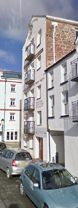
Planning Statement In Respect Of Alterations And Extensions, 2A, Water Street, Ramsey Im8 1Jp
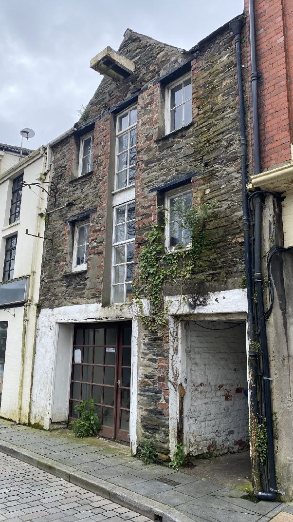
A street-level photograph showing the front elevation of a multi-story stone building with sash windows and a ground floor entrance.
1.0 Introduction
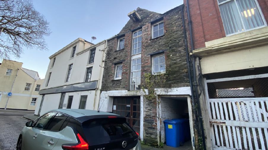
1.1 2A, Water Street is a three storey, stone faced building which sits facing the rear of the Courthouse building in the centre of Ramsey. The building is part of a terrace of buildings which comprise the side and rear of 2-4, Peel Street (shown as 10 Peel Street on the Government mapping), and on the other side of the building are the Masonic Buildings - a distinctive red bricked building which sits slightly taller than 2A and the rear of 2-4, Peel Street. The application building is currently laid out as offices.
1.2 The application property has two large apertures at ground floor level, one with glazing and serves as a door and window and the other, a presently open aperture which provides pedestrian access to the rear of this property and also to the rear of 8, Peel Street (currently "Good Stuff” restaurant and previous applications have referred to this property as 8-10, Peel Street).
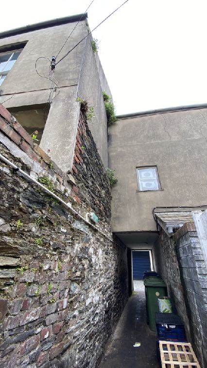
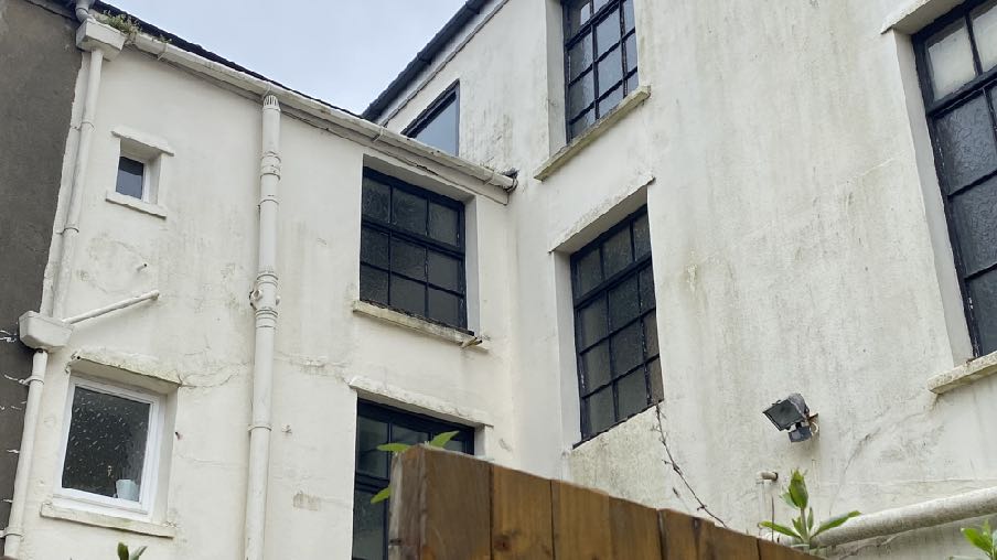
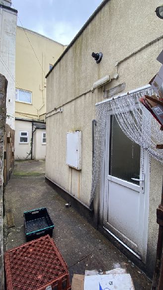
1.3 At the rear of the property is a single storey annex which is contained within a small rear yard which is also shared with 2-4, Peel Street. The rear elevation of the main part of 2-4, Peel Street has three floors of windows which overlook this yard as well as three floors of windows in the rear of the rear annex of this property. 2-4, Peel Street is used as an office
A street-level photograph showing a tall, narrow stone building with a gable end, situated between a white building and a red brick structure, with a car parked in the foreground.
at ground floor level with recent planning approval for use as a gaming lounge (21/00696/C) with the upper floors used as offices.
1.4 The windows in the properties alongside are mostly fitted with obscured glazing and the Masonic Buildings project out further at the rear than does the application property.
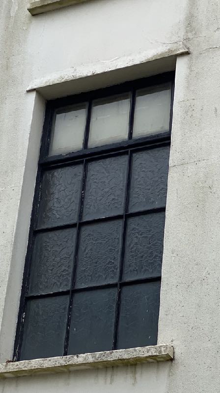
A low-angle photograph looking up a narrow rear alleyway flanked by a rough stone wall and a rendered building, leading to a blue door at the end.A close-up photograph showing a window with a black frame and textured glass set into a white rendered wall with a stone lintel and sill.
1.5 The building directly opposite the rear of the application site is a commercial kitchen with a pedestrian door opening out into the shared rear access lane.
A low-angle photograph showing the white rendered exterior wall of a building with dark-framed windows and a vertical downpipe. A wooden fence is visible in the foreground, indicating a boundary.A photograph showing the narrow side passage and rear wall of a building, featuring a white door with a beaded curtain and utility boxes.
1.6 The Masonic Buildings are also used as offices.
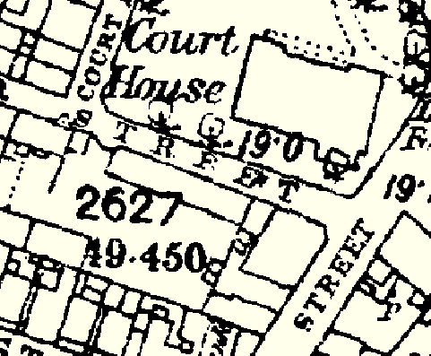
1.7 This part of Ramsey is now similar to its arrangement in the 1860s as can be seen on the County Series maps:
A black and white historical map or site plan showing property boundaries, building footprints, and street names such as 'Court House Street'.
2.0 Planning policy
2.1 The starting point for the determination of any development proposal is the land use designation. In the Isle of Man this currently takes the form of a variety of plans: the Isle of Man Planning Scheme (Development Plan) Order 1982 was the first development plan which was gradually superseded by a series of local plans in the 1980s and 90s and then in the 2000s onwards, these became Area Plans. The most recent Area Plans cover a large part of the island and there are adopted plans for the south and east. The remainder of the Island (the north and west) is the subject of an Area Plan which is in the process of preparation and is currently in draft form and to be the subject of a public inquiry in July 2024.
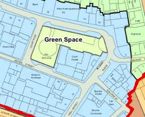
2.2 The site lies within an area designated on the Ramsey Local Plan adopted in 1999, as Mixed Use (Town Centre) which is the only adopted development plan for this site (below left):
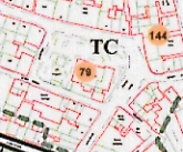
2.3 The site also lies within the town’s Conservation Area shown in green dashed lines above left. The Registered Building status of the Courthouse is also identified (“79”).
2.4 On the draft Area Plan for the North and West, the site is designated as Town Centre Parliament Street East (above right).
2.5 The Area Plan also contains maps which illustrate various types of constraint environmental and infrastructural. The Environmental Constraints applicable to this site are solely the Conservation Area.
A close-up view of a cadastral map or site plan showing property boundaries outlined in red, plot numbers such as 79 and 144, and the text 'TC'.This image displays a site location plan or cadastral map showing property boundaries, street names, and a designated 'Green Space' area.
2.6 The Infrastructure constraints include the identification of the site as within an area at risk of tidal flooding. This area extends to almost all of Parliament Street, Waterloo Road and Albert Road but exclude the Courthouse.
2.7 There are no trees, Registered or otherwise, on the site and the building on the site is not Registered, the nearest Registered Building being the Courthouse referred to above.
2.8 The land use designation then leads to policies which guide development. These policies are in both the Area/Local Plans and the Strategic Plan, which is generally a nongeographical policy document applicable to the whole Island.
Ramsey Local Plan Written Statement
2.9 This contains policies which encourage office development in the town centre (paragraph 4.18) but with little other guidance on the development of this area other than encouraging residential use above office and retail uses in the town centre (Policy R/R/P4 paragraph 3.15), a presumption in favour of retaining retail uses at ground floor level and no more than 30% of a frontage to be used for office uses including finance related establishments, although Water Street is not specifically referred to in the list of main shopping streets.
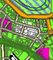
A low-resolution colored site location plan showing the property layout, surrounding roads, and green spaces.
Draft Area Plan for the North and West
2.10 The draft Area Plan for the North and West recognises the importance of Ramsey as a Service Centre, second only to Douglas in the settlement hierarchy in the Strategic Plan (see later) where development will be concentrated in the north of the Island. The overall issues for Ramsey Town Centre are stated in the draft plan as being:
1. How to respect and maintain the interactive relationships between the working harbours, the quay side businesses and town centre uses;
2. How best to define the ‘town centre’;
3. Strengthening the High Street and maintaining vibrant centres;
4. Creating attractive places where people want to and can: spend time, live, shop, work and easily move around;
5. Optimising the use of our centrally located sites which are vacant or underused and in a poor state of repair;
6. How to deal with flood risk in coastal locations which are seeing more regular and severe storm events as a result of climate change.
2.11 Development of unoccupied sites is encouraged at paragraph 8.6.3:
Comparably high building densities within the town limit the options for infill development to meet housing need, but the 2021 Census shows a high property vacancy rate of 16% and quayside buildings have become un-occupied in some areas. Bringing un-occupied sites and buildings back into re-use will benefit the local economy, enhance the townscape quality and increase the available number of residential dwellings.
2.12 The “Overview of Ramsey” explains at paragraph 9.3.1 that:
This Plan presents practical and sensible proposals for Peel and Ramsey and the other settlements in terms of their centres, however those centres are defined. It addresses local issues and puts forward clear and positive proposals that respond to those issues that affect each town centre. This Plan ensures a town centre focussed approach that will help to attract high quality investment and strengthen confidence and a will to develop and occupy sites. The opportunity has been taken to identify ‘mixed use zones’ as a planning tool to guide and protect development types.
9.3.4 Ramsey - The town centre in Ramsey is vulnerable to flood risk, particularly along the East Quay. Under-investment in quayside buildings has resulted in vacant properties and underoccupied urban sites that mar the public face of Ramsey. Consequently, there is a need for regeneration of these sites, together with sympathetic flood risk alleviation measures and public realm improvements, so as to enhance the public face of the town centre and bolster the local economy.
9.3.5 Setting out Town Centre Mixed Use Areas in Ramsey, defining a town centre boundary and providing suitably worded Town Centre Proposals provides a focus for both public and private sector investment and support a variety of uses that allows for greater flexibility to better respond to changing market demands. Providing greater flexibility of uses can be used as a mechanism to support viable regeneration initiatives in those areas where it is desirable to encourage regeneration, and to bring vacant premises back into commercial use, thereby enhancing the public face of the town.
2.13 The site falls into an area referred to as Parliament Street East where the following advice is provided at paragraph 9.8.3
MUA 2: Parliament Street: The eastern end continues to serve as the historic retail core. This area includes Parliament Street between the Christian Street/Parliament Street junction and Peel Street/Market Hill, opening out into a square at the Courthouse. Parliament Street is characterised by retail uses, with active shop frontages occurring at ground floor level. Storage and residential uses are found within the upper floors above shops. Court Row, Water Street and Peel Street accommodate financial and service uses. These uses complement the main retail uses in Parliament Street, and are easily accessible. The open space surrounding the Courthouse supports temporary market stalls and events. Gap sites can be found within the historic urban fabric.
9.8.4 Town Centre Proposal 2a: Parliament Street – East
1. Historic buildings in Parliament Street (East) should be retained, brought back into active use and sympathetically renovated. Sympathetic modifications that help to minimise flood risk and promote inclusive access will be supported;
2. The re-use of previously developed sites in Parliament Street is encouraged. The future design of new buildings should be resilient to flood risk, of high design quality and respond to the context of the vernacular character of Parliament Street East;
3. The predominant use within Parliament Street - East will be retail use and is identified as the ‘primary shopping area’. Retail uses shall be retained in this area. Residential and financial uses to upper floors are supported. Offices to support financial and professional services will be encouraged in Water Street, Peel Street and Court Row, together with community facilities such as creative arts studios;
4. Future uses should support an extended evening economy;
5. Future relocation of existing general industrial uses away from Water Street to areas designated for industrial uses will be supported if in alignment with any future regeneration strategy.
6. Any future improvements to public realm and public access or egress points shall ensure that the design is inclusive and accessible.
2.14 The Strategic Plan sets out generally non-geographic policies which apply Island wide. There is a general encouragement of sustainable development which is directed to established settlements (Strategic Aim, Strategic Policies 1, 2 and 10, Spatial Policy 5 and Housing Policy 4) with Ramsey being one of the five Services Centres which will provide regeneration and choice of location for housing, employment and services (Spatial Policy 2).
2.15 The design and appearance of development should be appropriate and of a high quality (Strategic Policies 3 and 5 and Environment Policy 42).
2.16 Development in areas designated for development is generally supported, provided that it complies with the following general standards of development:
General Policy 2: Development which is in accordance with the land-use zoning and proposals in the appropriate Area Plan and with other policies of this Strategic Plan will normally be permitted, provided that the development:
(a) is in accordance with the design brief in the Area Plan where there is such a brief;
(b) respects the site and surroundings in terms of the siting, layout, scale, form, design and landscaping of buildings and the spaces around them;
(c) does not affect adversely the character of the surrounding landscape or townscape;
(d) does not adversely affect the protected wildlife or locally important habitats on the site or adjacent land, including water courses;
(e) does not affect adversely public views of the sea;
(f) incorporates where possible existing topography and landscape features, particularly trees and sod banks;
(g) does not affect adversely the amenity of local residents or the character of the locality;
(h) provides satisfactory amenity standards in itself, including where appropriate safe and convenient access for all highway users, together with adequate parking, servicing and manoeuvring space;
(i) does not have an unacceptable effect on road safety or traffic flows on the local highways;
(j) can be provided with all necessary services;
(k) does not prejudice the use or development of adjoining land in accordance with the appropriate Area Plan;(l) is not on contaminated land or subject to unreasonable risk of erosion or flooding;
(m) takes account of community and personal safety and security in the design of buildings and the spaces around them; and
(n) is designed having due regard to best practice in reducing energy consumption.
2.17 Sustainable development which reduces journeys and energy use and increases thermal efficiency is now encouraged (Residential Design Guide (which also gives advice about design) and Climate Change Act 2021).
2.18 Existing buildings can often be converted to multiple apartments provided that certain criteria are met and which also relate to new proposals for apartments (Housing Policy 17 and Strategic Policy 12).
2.19 Development is expected to optimise/make the best use of sites (Strategic Policy 1).
2.20 Development within Conservation Areas must preserve or enhance the character or appearance of the area (Environment Policy 35 and Planning Policy Statement 1/01 Conservation of the Historic Environment of the Isle of Man CA2). There is a presumption against the demolition of buildings within a Conservation Area which make a positive contribution to the character or appearance of the area.
2.21 Registered Building consent is required for the demolition of any building or structure within a Conservation Area (Section 19 of the Town and Country Planning Act 1999).
2.22 Development which is at risk of flooding or would increase flood risk elsewhere is generally discouraged (Environment Policies 10 and 13).
2.23 The Residential Design Guide referred to in 2.21 above also provides advice on how the impact of new development on existing residential property, may be measured. This includes a general presumption against development where windows which look directly towards each other are closer than 20m and there are also 25 degree and 45 degree assessments to measure the impact on outlook and light. This does not refer to commercial units although the occupiers of adjacent buildings may make the point that their light/outlook is affected if there were to be an extension which failed these assessments.
3.0 Planning history
3.1 The planning history of an area can give an insight into what has previously been considered acceptable and unacceptable and provided there has been no change of circumstance or policy since then, the same conclusion should be reached in any future development proposals.
3.2 In this case, however there have been relatively few applications: the application property has been the subject of the following applications:
87/00538/B - alterations to front elevation including new shopfront - permitted
90/00299/D - erection of advertising - permitted
91/00355/C - change of use from commercial to residential accommodation - permitted
3.3 8-10 Peel Street received permission for replacement windows under 08/00606/B and 10/00176/B having been refused under 09/01925/B. They also had permission for an extension for additional living accommodation (92/00598/B). The restaurant use arrived in the early 1990s (90/01628/B and 91/01760/D).
3.4 The Masonic Buildings have not been the subject of any applications since 1984 when the modern record keeping commenced.
4.0 The proposal
4.1 Proposed is the demolition of the rear annex and its replacement with a wider and taller rear annex (but projecting no further out from the rear elevation than does the existing single storey annex) which will provide two floors of additional office accommodation in the form of toilets, lobbies and a staff room with a roof terrace on the second floor. The roof terrace is surrounded by a 1.25m high parapet wall and is accessed from the second floor office alongside. The rear annex will be finished in “cappuccino” coloured PVC cladding and all windows will be dark grey uPVC framed single lights.
4.2 On the front elevation the existing windows are to be replaced with dark grey coloured uPVC framed sliding sash with the central doors replaced with dark grey Crittal style windows with metal Juliet style balconies on the first and second floors. The existing large ground floor door and window will be replace with simpler aluminium folding doors in three sections.
5.0 Assessment and conclusion
5.1 The site accommodates an existing, historic building which is located within a settlement, in a sustainable location close to existing public transport links and is designated for Mixed Use on the adopted and draft development plans. Furthermore, the site lies within a Conservation Area where there is a presumption that development will either preserve or enhance the character or appearance of the area and also where investment in buildings of historic interest and character should be encouraged. The proposal retains the building as is preferred by Environment Policy 39.
5.2 The potential issues in this case are considered to be:
• The impact on the appearance and character of the area and the Conservation Area (General Policy 2 and Environment Policies 35 and 42)
• The impact of the proposed works on the occupants of adjacent buildings (General Policy
2) and
• The impact from and to the development in respect of tidal flooding (Environment Policies 10 and 13).
5.3 It is not considered that there will be any impact on highway safety nor any issue with the principle of the use of the building as there will be no changes in either respect. Whilst the application proposes an increase in the floor area of the building, this is not considered significant and given the nature of the proposed additional floorspace - toilets and lobbies mostly - it is not considered that this would create an unreasonable additional demand for car parking which is not met on site.
5.4 Impact on the appearance and character of the area and Conservation Area
5.4.1 This is possibly the most important consideration for development on this site given its CA status. The existing building has been altered over time, particularly at ground floor level but retains its original character above this, including the winch housing at the top of the front elevation. The further investment in this building should be welcomed as well as any efforts to increase the usability of the building.
5.4.2 The large window/door at ground floor level is not original. The proposed replacement of what exists with doors which mirror the proportion of the apertures above and all of
which will be framed in consistent material and colour will all enhance the character and appearance of the building and the Conservation Area in which it sits. The works to the front elevation are therefore considered to satisfy Environment Policy 35 and General Policy 2 of the Strategic Plan.
5.4.3 The proposed works at the rear take the form of a contemporary addition to the building which has been designed to be a simple addition to the structure and will not be publicly visible. There will therefore not be any adverse impact on the character and appearance of the Conservation Area which will be preserved.
5.5 Impact on those in adjacent property
5.5.1 The premises in the vicinity are largely commercial although some premises have residential accommodation on upper floors.
5.5.2 The existing building has only one window above ground floor level, that serving the first floor office. What is proposed has four windows on the first floor and an additional door in the second floor on the rear elevation.
5.5.3 The application drawings show the 45 degree impact of the proposed rear extension on the windows in 2, Water Street, the only windows affected being a very small window in the second floor and a slightly larger window on the first floor which is presently fitted with obscured glass. Three of the four openings in this rear elevation (with the exception of the smallest window) have obscured glazing on at least the bottom two thirds of each window.
5.5.4 In 2-4, Peel Street there are two windows in the second and third floor which will look out towards the proposed additional building although there is a clear and uninterrupted outlook from these windows to the west across the open yard. These windows are fitted entirely with obscured glazing as are the other two windows to the south.
5.5.5 The building directly behind the proposed rear extension is the kitchen which serves the restaurant in 8, Peel Street and is a single storey annex of the main building.
Flood risk
5.6.6 The site lies within an area identified as being at risk from tidal flooding although it is noted that the Courthouse building across Water Street is not so identified. The proposed development will not significantly change or increase this risk through the replacement of an
existing door and window on the front elevation with a set of doors nor through the modest increase of ground floor space at the rear given the scale of the extension and the nature of the space being created.
5.6.7 The Development Procedure Order does not require a Flood Risk Assessment for applications for extension where there is no change of use involved. Furthermore, the building is an office and will remain so, which is not generally considered to constitute a vulnerable use. The building is likely to be used in the daytime, will not have any overnight sleeping accommodation and certainly not on the ground floor, and the additional ground floor space at the rear will accommodate a toilet, lobby and small staff kitchenette space (big enough only for a fridge and sink), none of which will result in persons being within these spaces for any significant length of time. As such, the risk of harm to personal safety from flooding is considered to be low. In addition, the flood risk relates to tidal flooding which is more predictable than other forms of flooding and can result in adequate preparation being undertaken in advance.
5.6.8 However, the application acknowledges the potential risk of flooding, bearing in mind that the building exists and there is no potential for increasing the floor level of the building. The rear extension ground floor level will be 100mm higher than the existing annex and is the maximum that can be achieved given the floor levels above. In addition, the following will be employed in the implementation of the proposed works:
• The sealing of new services entering the building
• Addition of non-return valves in the underground drainage system serving the property
• Tiled floor finishes and skirtings to the ground floor
• The use of solid wood or steel for the internal doors, fixtures and fittings instead of particle board.
• The use of water resistant wall lining materials such as cement board instead of standard plasterboard.
• All electrical sockets and switches to be positioned at least 1m above the ground floor level.
6.0 Conclusion
6.1 This is a highly sustainable site within a Conservation Area, and with the Courthouse Registered Building in close proximity. It is highly beneficial to both the Conservation Area and the town centre more generally for this building to be capable of accommodating a viable use which will ensure its continued maintenance and occupation. The draft Area Plan specifically encourages the use of buildings in Water Street as offices to support the professional and financial sector and the optimisation of sites is encouraged in Strategic Policy 1.
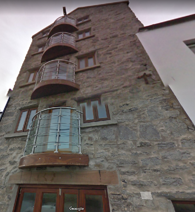
5.2 It is considered that the proposed window and door replacements on the front elevation will enhance the building. Similar warehouse type buildings elsewhere in the Island, within Conservation Areas, have been subject to modernisation and sympathetic treatment, such as the Viking Longhouse in Peel and Castletown below respectively:
A street-level photograph showing a row of buildings, including a white building with balconies and a sign, alongside a building with exposed stone upper walls. Cars are parked on the street in the foreground.A low-angle photograph of a tall, multi-story stone building featuring curved balconies and wooden window frames, likely a converted barn or substantial house.
5.3 Whilst there is a requirement for car parking, the building exists and has no parking at present, but is within the town centre where there are other forms of transport and where walking an cycling would be possible to and from other amenities and facilities.
5.4 Flood risk needs to be taken into account but the building exists and the proposed extension is not considered substantial, particularly at ground floor level. The proposal does not materially change the type or level of use. However, a range of flood defence measures are proposed to reduce the risk of damage from any flood water which could enter the building.
5.5 The proposed rear annex as proposed will provide opportunities for additional facilities to be provided for the building without taking away valuable commercial floor space and the roof terrace will provide welcome staff leisure space.
5.6 Any rear extension has the potential to create an adverse impact on the outlook and privacy of those in adjacent properties. The extension has been designed to avoid having a significant or adverse impact on the outlook from principal windows in any of the adjacent properties and whilst there are new windows proposed in the application building at the rear, these will look towards a commercial kitchen and not towards any residential or sensitive accommodation. It is noted that almost all of the windows in the properties to the west are fitted with obscured glazing.
5.7 We believe that the proposal will positively affect the Conservation Area through sympathetic alterations to the front elevation which will enhance the appearance of the building and with these, and the addition at the rear enabling the building to be more usable and a more attractive suite of accommodation, leading to its continued occupation and maintenance.
Sarah Corlett 04.06.2024
Appendix One
Relevant Strategic Plan policies
Strategic Aim: To plan for the efficient and effective provision of services and infrastructure and to direct and control development and the use of land to meet the community’s needs, having particular regard to the principles of sustainability whilst at the same time preserving, protecting, and improving the quality of the environment, having particular regard to our uniquely Manx natural, wildlife, cultural and built heritage.
Strategic Policy 1: Development should make the best use of resources by:
(a) optimising the use of previously developed land, redundant buildings, unused and underused land and buildings, and reusing scarce indigenous building materials;
(b) ensuring efficient use of sites, taking into account the needs for access, landscaping, open space(1) and amenity standards; and
(c) being located so as to utilise existing and planned infrastructure, facilities and services.
Strategic Policy 2: New development will be located primarily within our existing towns and villages, or, where appropriate, in sustainable urban extensions(2) of these towns and villages. Development will be permitted in the countryside only in the exceptional circumstances identified in paragraph 6.3.
Strategic Policy 3: Proposals for development must ensure that the individual character of our towns and villages is protected or enhanced by:
(a) avoiding coalescence and maintaining adequate physical separation between settlements; and
(b) having regard in the design of new development to the use of local materials and character.
Strategic Policy 4: Proposals for development must:
(a) Protect or enhance the fabric and setting of Ancient Monuments, Registered Buildings(1), Conservation Areas(2) , buildings and structures within National Heritage Areas and sites of archaeological interest;
(b) protect or enhance the landscape quality and nature conservation value of urban as well as rural areas but especially in respect to development adjacent to Areas of Special Scientific Interest and other designations; and
(c) not cause or lead to unacceptable environmental pollution or disturbance.
Strategic Policy 5: New development, including individual buildings, should be designed so as to make a positive contribution to the environment of the Island. In appropriate cases the Department will require planning applications to be supported by a Design Statement which will be required to take account of the Strategic Aim and Policies.
Strategic Policy 10: New development should be located and designed such as to promote a more integrated transport network with the aim to:
(a) minimise journeys, especially by private car;
(b) make best use of public transport;
(c) not adversely affect highway safety for all users, and
(d) encourage pedestrian movement.
Spatial Policy 5: New development will be located within the defined settlements. Development will only be permitted in the countryside in accordance with General Policy 3.
General Policy 2: Development which is in accordance with the land-use zoning and proposals in the appropriate Area Plan and with other policies of this Strategic Plan will normally be permitted, provided that the development:
(a) is in accordance with the design brief in the Area Plan where there is such a brief;
(b) respects the site and surroundings in terms of the siting, layout, scale, form, design and landscaping of buildings and the spaces around them;
(c) does not affect adversely the character of the surrounding landscape or townscape;
(d) does not adversely affect the protected wildlife or locally important habitats on the site or adjacent land, including water courses;
(e) does not affect adversely public views of the sea;
(f) incorporates where possible existing topography and landscape features, particularly trees and sod banks;
(g) does not affect adversely the amenity of local residents or the character of the locality;
(h) provides satisfactory amenity standards in itself, including where appropriate safe and convenient access for all highway users, together with adequate parking, servicing and manoeuvring space;
(i) does not have an unacceptable effect on road safety or traffic flows on the local highways;
(j) can be provided with all necessary services;
(k) does not prejudice the use or development of adjoining land in accordance with the appropriate Area Plan;
(l) is not on contaminated land or subject to unreasonable risk of erosion or flooding;
(m) takes account of community and personal safety and security in the design of buildings and the spaces around them; and
(n) is designed having due regard to best practice in reducing energy consumption.
Environment Policy 4: Development will not be permitted which would adversely affect:
(a) species and habitats of international importance:
(i) protected species of international importance or their habitats; or
(ii) proposed or designated Ramsar and Emerald Sites or other internationally important sites.
(b) species and habitats of national importance:
(i) protected species of national importance or their habitats; (1) Wildlife Sites are defined in Appendix 1 41
(ii) proposed or designated National Nature Reserves, or Areas of Special Scientific Interest; or
(iii) Marine Nature Reserves; or
(iv) National Trust Land.
(c) species and habitats of local importance such as Wildlife Sites, local nature reserves, priority habitats or species identified in any Manx Biodiversity Action Plan which do not already benefit from statutory protection, Areas of Special Protection and Bird Sanctuaries and landscape features of importance to wild flora and fauna by reason of their continuous nature or function as a corridor between habitats.
Some areas to which this policy applies are identified as Areas of Ecological Importance or Interest on extant Local or Area Plans, but others, whose importance was not evident at the time of the adoption of the relevant Local or Area Plan, are not, particularly where that plan has been in place for many years. In these circumstances, the Department will seek site specific advice from the Department of Agriculture, Fisheries and Forestry if development proposals are brought forward.
Environment Policy 10: Where development is proposed on any site where in the opinion of the Department of Local Government and the Environment there is a potential risk of flooding, a flood risk assessment and details of proposed mitigation measures must accompany any application for planning permission. The requirements for a flood risk assessment are set out in Appendix 4.
Environment Policy 13: Development which would result in an unacceptable risk from flooding, either on or off-site, will not be permitted.
Environment Policy 35: Environment Policy 35: Within Conservation Areas, the Department will permit only development which would preserve or enhance the character or appearance of the Area, and will ensure that the special features contributing to the character and quality are protected against inappropriate development.
Environment Policy 39: The general presumption will be in favour of retaining buildings which make a positive contribution to the character or appearance of the Conservation Area.
Environment Policy 42: New development in existing settlements must be designed to take account of the particular character and identity, in terms of buildings and landscape features of the immediate locality. Inappropriate backland development, and the removal of open or green spaces which contribute to the visual amenity and sense of place of a particular area will not be permitted. Those open or green spaces which are to be preserved will be identified in Area Plans.
Transport Policy 7: The Department will require that in all new development, parking provision must be in accordance with the Department’s current standards.
Planning Policy Statement 1/01 - Conservation of the Historic Environment of the Isle of Man
POLICY CA/2 SPECIAL PLANNING CONSIDERATIONS When considering proposals for the possible development of any land or buildings which fall within the conservation area, the impact of such proposals upon the special character of the area, will be a material consideration when assessing the application. Where a development is proposed for land which, although not within the boundaries of the conservation area, would affect its context or setting, or views into or out of the area; such issues should be given special consideration where the character or appearance of a conservation area may be affected.
POLICY CA/6 DEMOLITION Any building which is located within a conservation area and which is not an exception as provided above, may not be demolished without the consent of the Department. In practice, a planning application for consent to demolish must be lodged with the Department. When considering an application for demolition of a building in a conservation area, the general presumption will be in favour of retaining buildings which make a positive contribution to the character or appearance of the conservation area. Similar criteria will be applied as those outlined in RB/6 above, when assessing the application to demolish the building, but in less clear cut cases, for example, where a building could be said to detract from the special character of the area, it will be essential for the Department to be able to consider the merits of any proposed new development when determining whether consent should be given for the demolition of an unregistered building in a conservation area. Account will be taken of the part played in the architectural or historic interest of the area by the building for which demolition is proposed, and in particular of the wider effects of demolition on the building’s surroundings and on the conservation area as a whole.
Copyright in submitted documents remains with their authors. Request removal
Source & Provenance
Official reference
24/00690/B
Source authority
Isle of Man Government Planning & Building Control