PLANNING STATEMENT FOR THE OVERNIGHT PARKING OF A MOTORHOME, AXNFELL PLANTATION PICNIC AREA AND CAR PARK, CHIBBBYR PHERICK ROAD, GLEN ROY, LAXEY
24/00590/C
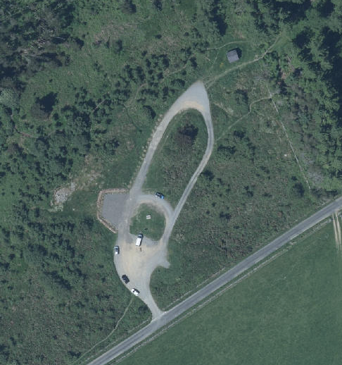
An aerial view of a rural property showing a looped driveway and parking area with several vehicles parked near a main road.
1.0 Introduction
1.1 As the site is owned and managed by Department of Environment, Food and Agriculture, the application should be referred to the Council of Ministers for determination under Article 16 (1)(b) of the Town and Country Planning (Development Procedure) Order 2019.
1.2 The site is part of a small informal car park and picnic area which serves Axnfell Plantation, a wooded area which has the Glen Roy river running eastwards towards Laxey, to the north and the Chibbyr Pherick Road to the south.
1.3 Axnfell Plantation extends to approximately 36 hectares (88 acres) and includes a steeply sloping wooded glen and more open, naturally vegetated areas with paths running throughout. The glen is used for leisure and recreation including motorcycle trials from time to time cycling and walking.
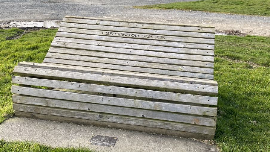
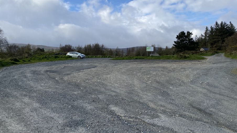
1.4 There is a small area for parking which also has a star gazing bench and information board to the south of the wooded area as well as another bench with memorial plaque to the west of this. The parking area includes roughly surfaced informal areas which are also used for turning and access, and a more formal area off the circulation area, to the west of the informal tracks.
1.5 This application proposes to permit overnight stays by a motorhome within the formal parking area where the vehicle is parked in the photographs above. As this will involve people sleeping and
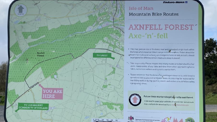
A photograph of an information sign displaying a map of the Axonfell Forest mountain bike routes with a 'You Are Here' marker.
staying within the car parking area, it is believed that this represents a material change of use of the car park for which planning approval is required.
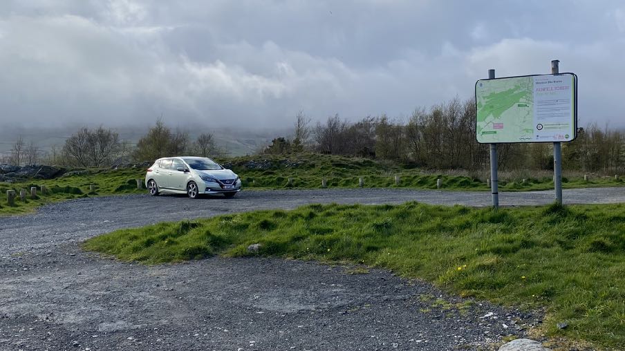
A photograph showing a gravel parking area with a white car and a large information sign board displaying a map.A photograph of a wooden bench with 'CELEBRATING OUR DARK SKIES' carved into the backrest, situated on a concrete pad next to grass and a gravel path.
1.6 The car park is managed by the Department as part of its estate rather than being subject to separate legislation although the Forestry Act 1984 enables the Department to do the following: “lay out, plant and improve any land vested in them, in connection with the use of such land by the public for the purpose of recreation, and in particular erect buildings and carry out works, to provide facilities and services for the enjoyment and convenience of the public, including meals and refreshments, camp-sites, parking places for vehicles, shelters and toilets, and provide facilities and services for open-air recreation”.
A wide-angle photograph of a gravel parking area or layby in a rural setting, featuring a white car parked on the left side with hills and trees in the background.
2.0 Planning policy
2.1 Planning policy takes a number of forms: development plans set out what purpose or function land is designated for - land is designated for a particular purpose or not - and these development plans take the form of a variety of adopted Area or Local Plans (or where there is neither, Isle of Man Planning Scheme (Development Plan) Order 1982). Above this, there is the Isle of Man Strategic Plan 2016 which is not geographic but provides over-arching strategic policies which apply across the Island. Area Plans should be in general conformity with the Strategic Plan but where there is any contradiction or conflict, whichever was adopted later would prevail (paragraph 1.4.4).
2.2 Consideration can also be given in the determination of any planning application, to Planning Policy Statements, Planning Circulars, National Policy Directives (there is none as yet) or other statements of planning policy as well as other Government policies (Section 10(4) of the Town and Country Planning Act 1999. Planning involves a balance of all of these considerations as well as anything else which could be considered a material consideration. In this case we believe that the Government Economic Strategy (including the Annual Report of December 2023) and the Island Visitor Strategy are both material considerations which should be given weight in the planning balance.
2.3 Area Plan for the East (2020)
2.3.1 The site lies within an area designated on the Area Plan for the East as not for a particular purpose and is as such, considered as part of the countryside.
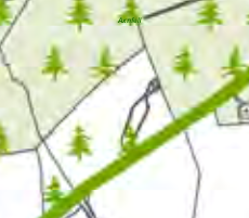
2.3.2 The tree symbols on the Environmental Constraints map which accompanies the Area Plan, denotes plantation and the light green shaded area indicates an area of predominantly woodland or
A detailed section of a site plan displaying property boundaries, tree symbols, and a building footprint.
trees. The site is designated on the Island Environment Map as an area for recreation on hill lands and in plantations where it is the Department’s policy to allow recreation.
2.3.3 The trees within the plantation are not Registered.
2.3.4 The opportunities for tourism within the woodlands and plantations is recognised in the Area Plan as follows:
Tourism Proposal 6 The provision of low key rural tourist accommodation such as small scale camping pods in woodlands/plantations in the East will only be acceptable where it can be demonstrated that there will be no adverse impact on the character and appearance of the landscape and the environment generally. Planning conditions will be imposed seeking removal of buildings no longer required for such uses.
2.3.5 The draft Area Plan incorporates the findings of the Landscape Character Assessment which identifies the site as falling within an area of D3 Conrhenhny and Groudle Incised Inland Slopes where the following guidance is provided (the full description in the original 2008 Assessment is set out in Appendix One):
Landscape Strategy Conserve and enhance:
a) the character, quality and distinctiveness of this area, with its relatively sparse settlement other than the characteristic settlement of Laxey;
b) its distinct small-scale field pattern;
c) its valley bottom woodland along National Glens;
d) the setting of the various historic and archaeological features within the area.
Key Views Dramatic views to an Upland backdrop to the North and West. Channelled views East and West along the corridor of Laxey Glen. Views to the instantly recognisable Lady Isabella water wheel as a landmark within the area. Panoramic views eastwards across the sea from areas of higher land within the character area.
2.4 Isle of Man Strategic Plan 2016
2.4.1 There is a general presumption against development in undesignated areas, as set out in General Policy 3 of the Strategic Plan (see Appendix One). Environment Policies 1 and 2 presume
against development which would be harmful to the character and appearance of the countryside, EP 2 placing even more weight on the protection of the character and quality of the countryside in areas which were identified on the Isle of Man Planning Scheme (Development Plan) Order 1982 as of an area of High Landscape or Coastal Value and Scenic Significance which includes this site although these areas have been replaced by the Landscape Character Assessment.
2.4.2 There are no buildings on the site, Registered or otherwise. The site is not within a Conservation Area. There are no Registered Trees on the site.
2.4.3 The Strategic Plan acknowledges the value of open, undeveloped space:
10.3.2 Open Space forms part of our heritage as well as being an attractive and usable asset, and, in the wider context, provides visual and spiritual relief from the developed urban settlements on the Island. In addition, it provides recreational enjoyment in respect of various active and some less active forms of sporting activity. Open Spaces also provide a means of improving the health and fitness of the Island’s population. Open Space is defined in this context as land used for recreational purposes, both formal and informal, including amenity space whether privately or publicly owned.
2.4.4 Development which would adversely affect the environment is presumed against (Environment Policy 22) and
7.17.2 In addition to the above, changes in the activities associated with the current permitted use of land or a building, which in themselves do not constitute development and therefore do not require planning permission, can have an adverse impact on adjacent properties by virtue of noise, light or general disturbance. For example the addition of security lighting on a property may cause light pollution affecting adjacent properties and the wider area. The introduction of new activities into established parks and recreation areas can have an impact on neighbours. In such cases the Department would advocate the person or organisation considering the change to give careful consideration to the potential impact of such activity in terms of location, siting and design.
2.4.5 Development for the improvement of existing facilities must have regard to any potential adverse impact on those in neighbouring property (Environment Policy 23).
2.4.6 Whilst tourism is not one of the exceptions listed in General Policy 3, Government has an adopted strategy, Our Island, Our Future, which promotes tourism. This document, coupled with the Economic Strategy promote the development of tourism as part of the general objective to build “a
secure, vibrant and sustainable future for our Island”. The economic strategy talks of ensuring that the Island’s amenities and leisure facilities are attractive and developing a tourism offering which is more diverse, supports our Island all year round, and is a valued and growing part of our Island’s proposition for both visitors and residents. It also talks of expanding the availability of facilities and activities for target demographics, in particular improving options for children, young people, and families.
2.5.7 The Tourism Strategy provides a more detailed look at how the industry should be responding to the need for the tourism offer to develop. It specifically refers to the creation of a motorhome stopover network within the Island and clarifies the value of tourist facilities for those visiting the Island as well as those who live on it and may wish to have a break without leaving the Isle of Man. It explains that “The campaign focuses on celebrating the Island’s uniqueness through its ancient and compelling history, and beautiful vibrant landscapes which provide a playground for visitors of all ages, demonstrating the extraordinary experiences available in any season on the Isle of Man.”
2.4.8 Axnfell Forest is a Dark Skies Discovery Site.
3.0 Planning history and relevant applications
3.1 The site itself has not been the subject of any applications although the small stone building close by was the subject of an application for re-roofing the building which was permitted (15/00401/B).
3.2 Development which supports the Government’s Visitor Strategy have been considered acceptable where the site was not designated for development and examples of this include Reayrt Vradda in Port Erin (20/00496/B) where a 30 glamping pod/cabin, camping site was approved and is being implemented, and at Broogh Fort (22/01064/B) where an application for change of use from a residential dwelling to three tourist units was initially refused as the site was not designated for development, but permitted on appeal where the inspector noted that:
55. This appeal turns on the acceptability of the proposed conversion with respect to planning policy and Government guidance related to tourism, in the light of the effects of the development on the appearance, character and amenity of the site and surrounding area and any benefits that would accrue as a result of its implementation
56. A wide range of adopted planning policy generally supports proposals for the creation of tourist accommodation by conversion of rural buildings, whilst applying the same level of control over environmental impact as to other forms of development. In this regard I refer to StrP5, BP11-12, BP14 and EP13 of the IMSP noted above.
57. However, StrP8, GP3, EP16 and HP11 of the IMSP together maintain the provisos that such buildings for conversion should be redundant from their previous use, should be of high quality fabric or interest or otherwise occupy previously developed land or be required for countryside interpretation or in the national interest.
58. First, it is not disputed in this case that the proposed conversion would not qualify in terms of any of these policy criteria or exceptions.
59. At the same time, I consider it equally beyond dispute that, as set out above in the cases of both the Appellant and the Department, the proposed development would have no unacceptably adverse visual, amenity or highway impacts upon the appeal property or on any neighbours or on the wider rural landscape. Therefore, there would be no conflict with the aims of EP1 or GP2 of the IMSP to protect the countryside for its own sake and the environment generally.
60. Moreover, Government guidance, in particular the Tourism Strategy and draft Economic Strategy, supports new tourist accommodation in a more diverse, year-round
tourism offer within a growing the Island economy. This appears to have been reflected in the several examples of previous tourism approvals cited by the Appellant.
I have reached the overall conclusion that the lack of planning harm, the positive provision of desirable tourist accommodation and the benefits that would arise due to the development together outweigh any degree of conflict with StrP8, GP3, EP16 or HP11 of the IMSP and justify the approval sought in this case.
3.3 The Department owns and manages a substantial part of the Island and is trying to maximise the use of and benefit from these areas in line with adopted recreation and leisure and tourism strategies. In this respect it has recently gained planning approval for the parking of catering vans in three of the Island’s plantations. The inspector who considered the applications reached the same positive conclusion in all cases, making the following comments:
11. However, the accompanying text in Chapter 5 of the written statement which relates to the Natural Environment sets out that the plantations, have significant recreational amenity and there is scope to develop this further. Most of the working forests are open to the public and are popular with walkers, horse riders and cyclists and several are being developed for further recreation purposes through the addition of car parks and other facilities.
47. The proposed change of use would allow for the stationing of a mobile catering facility, the exact nature of which is not yet known, and would depend on the operator appointed to manage the unit. The Applicant has indicated that there are a number of options which would likely include converted vehicles such as vans, horse boxes, caravans and trailers. However, the common denominator would be that it would be a single catering unit and would have to be mobile. I agree with the Planning Authority that the parking of the vehicle would not need permission as the land is a car park. It is the use for business purposes which takes the land use into a different category of use.
48. Whatever the mobile catering unit ends up being, in visual terms, as a parked vehicle it would not be discernible from the other parked vehicles which use the car park. Even if it was parked for longer periods, which is likely over the summer season, as a parked vehicle it would not appear as an unexpected feature within the context of the car park. Therefore, the mobile catering unit would not, in itself, harm the character and appearance of the countryside environment.
49. The use of the unit for the preparation of food and drink and the sale of such items would be small scale and is unlikely to generate customer activity other than in
association with the recreational use of the Archallagan Plantation. It would be a facility which may encourage those wishing to enjoy the outdoors, to come to the Plantation knowing car parking is available, as well as somewhere to enjoy a cup of tea or coffee and a sandwich or cake after a walk or ride in the forest. It would facilitate recreational activities by providing refreshments and an opportunity to linger to enjoy the expansive views across the Island and consider the interpretation of the countryside.
50. The proposal would also provide the opportunity for the establishment of a new business supporting growth of employment on the Island.
51. For the reasons set out above it is reasonable to conclude that the proposed change of use for the stationing of a mobile catering unit and the consequential establishing of a business providing refreshments within the Archallagan Plantation car park, would not cause identifiable harm to the countryside environment nor to any other material considerations which might compromise established planning policy and weigh negatively against granting of permission in this instance.
3.4 It should be noted that some of the sites of the catering vehicles are also sites where it is proposed to accommodate overnight parking of motorhomes although the motorhome parking spaces are not in the same parking space within each car park, as will be the catering vehicles. The Axnfell car park and picnic area was not the subject of an application for one of these catering vehicles.
4.0 The proposal
4.1 This application, is seeking permission for the overnight accommodation of a motorhome within the site. As this involves people staying on the site, in the vehicles, we believe this represents a material change of use and as such, planning permission is being sought. It should be noted that there is nothing to prevent the overnight parking of any vehicle within the car park (where no-one is remaining in the vehicle) other than the land owner’s own regulations or preferences.
4.2 The application proposes a motorhome parking space in the small formal car parking area. No electric hook ups, toilets or other facilities are being proposed nor any additional lighting as the vehicle is expected to have its own cooking, sleeping, toilet and washing facilities. This is particularly important here due to the Dark Skies status. Anyone intending to stay here would know through the marketing and booking material that there are no facilities on site and if there is a need for recharging, emptying etc, then they would programme their stay so that they will stay at a site where they can do this, before or after their visit to this site, for example at a permanent camp site.
4.3 It is intended that the users of the vehicle will book in advance to stay at the site and may stay for a prescribed period, probably around a maximum of four nights per site during any one stay and the authorised parking period would run between 1800hrs until 0800hrs the following day. Those staying on the site might wish to take advantage of the footpath network which is accessible from this site as well as the many visitor attractions in Laxey - the Lady Isabella Water Wheel, Laxey Glen and Gardens, the former mines washing floor and Lady Evelyn water wheel, the beach and harbour and many restaurants and cafes, all of which are within reasonable walking distance of the site.
4.4 It is anticipated that the motorhome would be parked on this site, as part of a series of stops in other parts of the Island - the network referred to in the Visit IOM’s strategy. The sites would be available for overnight parking throughout the year.
4.5 The allocated parking space would be identified through signage rather than surface marking.
4.6 Enforcement of the occupation of the space would be undertaken through the existing car park management regime.
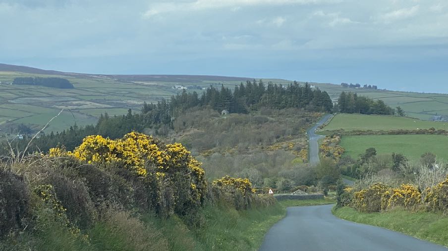
4.7 The site is close to a public highway although a lightly trafficked one due to the restricted width of road at the northern end and the sharp turn down onto Rencell Hill although it is accepted that at times, motorists use this as an alternative to the A2 coast road to get to and from work.
4.8 Monitoring of the appropriate use of this parking space would be undertaken by the Department as they currently manage this car park.
4.9 In terms of impact, it is reiterated that in planning terms, there is nothing to prevent vehicles being parked in this car park overnight, were they unoccupied and this space could be occupied by a vehicle or vehicles, including larger vehicles at any time (provided that this was not a permanent use). As such, the visual impact of one motorhome parked in this car park is not considered to be such as to warrant refusal of this application.
4.10 Similarly, there is nothing to prevent any vehicle driving into and out of the site at any time and as such, there can be no objection to the application on the basis of highway safety.
4.11 Whilst the site itself is relatively isolated, this itself leads to those staying on the site having the opportunity to be surrounded by spectacular scenery and its flora and fauna as well as being within a Dark Skies Discovery Site without any unnatural light sources or facilities to impair their appreciation of the natural environment.
A landscape photograph showing a winding rural road flanked by hedgerows with yellow gorse, leading towards a distant view of the coast and fields.
5.0 Responses to the comments made
5.1 There have been criticisms of the principle of this type of overnight camping opportunity in that the proposal does not involve the provision of any facilities - waste disposal, electricity etc. The stopover points are to be exactly that: not fully equipped camp sites which are used exclusively for that purpose and are very different to the various camp sites around the Island which have a range of facilities - electricity, sewage disposal, wet weather facilities, toilet and shower blocks - and are designed for short term stays. They are designed to be used short term as part of a network of sites which offer varying levels of facilities and enable visitors (or locals) to stay in many different parts of the Island with its different offerings of cultural, natural and recreational facilities and attractions. As such, whilst it is understood that some of the contributors consider that the sites will be less attractive or not desirable if they have no such facilities, this will be demonstrated if the application is permitted and the spaces are advertised and there is either no demand for them or any initial use is not maintained longer term. If this occurs then each site can continue as a parking space to serve the site in or next to which it is located as no physical changes are proposed in any of the cases.
5.2 The Department is aware that there are many instances of “wild camping” and unauthorised motorhome parking, some of which have adverse impacts on ecology, adjacent neighbours and/or the visual impact of the area, particularly where a large number of campers arrive at one time. This initiative is aimed at providing authorised facilities in areas and in scale that will not result in such impacts on the surrounding areas.
5.3 The test should be whether the proposal is acceptable in planning terms.
5.4 The nature of the type of camping facility will be communicated to the potential campers when they book the space and the facilities or lack of will be clearly stated so that potential campers are aware of what the site will offer. This site is particularly remote and those wishing to stay here are unlikely to be people seeking well illuminate family oriented camp sites with electricity, waste disposal facilities and an obviously managed presence.
5.5 The site is a car park where anyone may park either during the day or in the evening. As such, it is not understood how a motorhome parked in this location overnight would obstruct access to the rocky area beyond any more than would one or two legitimately parked vehicles, potentially motorhomes which could be parked here at any time but just could not be occupied overnight. There is nothing to prevent a motorhome parking here during the day when it is more likely that access would be required and where it would be much more visible from the surrounding area than during the evening and overnight when the vehicles are unlikely to be seen or that there would be many people to see them.
5.6 The site is monitored by the Department’s wardens and rangers as part of their estate checks.
5.7 Whilst it is accepted that at certain times of the day the adjacent highway is used by some motorists avoiding the A2, and when the Mountain Road is closed from the Creg na Baa catching some motorists heading north, unawares, in the later evenings the road is less busy. There has been no objection to the application from the Highway Services Division of Department for Infrastructure and no evidence that motorhomes accessing this site - as they are free to do currently - would be the cause of any adverse effect on highway safety.
5.8 It is hoped that this clarifies the position in respect of this application and addresses the issues which have been raised thus far.
6.0 Conclusion
6.1 The site is not designated for development but it is clear from the Strategic Plan and the decisions taken in respect of various applications that tourism development which supports Government Strategy can be considered acceptable for that reason. We would suggest that the application supports the Government’s Tourism Strategy in being part of a network of overnight stops for motorhomes and will not only provides facilities for those who already come to the Island in their motorhomes, but also may attract new motorhome tourists to the Island.
6.2 The recent Government Economic Strategy 2022 - 2032 aims to create a “secure, vibrant and sustainable future” for the Island, “improved health and well being” and By actively investing in key services & infrastructure that attract and retain economically active people, supported by a range of incentives and disincentives to sustain targeted growth” with the Island becoming an even more attractive place to live. These investments include culture, light and transport facilities whilst protecting the natural environment and “expanding and improving facilities and activities for children, young people and families”.
6.3 The application is aimed at providing new visitor facilities and will also support existing camp sites where motorhomes are permitted, enabling visitors to stay in various parts of the Island rather than staying in one location and enabling visitors to experience more of the Island and the attractions it offers. The Visitor Strategy specifically refers to the desirability of establishing a network of motorhome stop over sites.
6.4 There are no residential properties within the vicinity of the site which could be affected by the proposed additional use of this car park for the overnight parking of one vehicle and we would suggest that there will be no adverse environmental or visual impact as a result of what is proposed. As such, we would submit that the proposal is not in conflict with any of the policies within the Strategic Plan or any relevant local or Area Plan for this site and will support the Government strategy on promoting tourism on the Isle of Man.
Sarah Corlett 15.10.24
Appendix One
Landscape Character Assessment
D3 CONRHENNY/GROUDLE Key Characteristics
• Gently rolling topography, which is cut by a series of rivers.
• Contain the relatively narrow corridors of the Groudle and Ballacottier Rivers.
• Patchwork of organised pasture and arable fields delineated by a combination of hedgerows, Manx banks and visible drainage ditches.
• Patches of regular coniferous woodland plantations as visible landmarks with the surrounding landscape.
• Distinctive black and white Manx milestones lining the A2 road corridor.
• Series of scattered, isolated farmsteads (several of which have associated modern farm buildings).
• Sense of enclosure provided by Uplands to the north-west.
• Open views to visually harsh red roofs of modern housing developments at the edge of Onchan dominate views southwards.
• Dramatic, panoramic views eastwards across the ever-changing colour and nature of the sea and sky, contribute to strongly recognisable sense of place.
Overall Character Description This character area encompasses gently rolling topography, which is cut by a series of small rivers and streams, including Groudle River and Ballacottier River, which flow north-south across the area. To the north of Onchan, the Groudle River has been dammed to form two triangular reservoirs, Kerrowdhoo and Clypse, which are visible on the horizon on approach to the area. Landscape within the area is covered by a patchwork of organised pasture and arable fields, which are delineated by a combination of hedgerows and Manx banks. Ditches are also characteristically visible at field boundaries in certain locations. Three regular-shaped coniferous woodland plantations are situated on sloping land to the northeast of Onchan and provide recognisable sense of place. Set against a dramatic upland backdrop, these woodlands create a sense of enclosure surrounding Conrhenny equestrian centre and provide recognisable landscape features within an otherwise predominantly open landscape. To the south, the area is served by the main A2 road, which runs along the coastline and connects Douglas in the south to Laxey in the north. A series of relatively quiet, rural roads lead northwards from this main road corridor, towards the upland backdrop. Settlement pattern consists of a series of scattered, isolated farmsteads, several of which have visually intrusive modern farm buildings in proximity to the older, traditional farmhouses. A sense of enclosure is provided by Uplands to the northwest. Overall, there is a relatively strong sense of tranquillity throughout the character area, at distance from major roads corridors and the edges of Onchan. To the north of Onchan, the geometric course of the A18 (TT course), with several viewing platforms and Marshals’
boxes, provides a recognisable transport corridor within the area. The sense of tranquillity is greatly disturbed during TT season. The meandering path of the Groudle River (which is enclosed and wooded in places) abuts the north-eastern edge of Onchan and flows eastwards to join the sea at Port Groudle. Just to the south of this river corridor, King Edward Bay golf course (situated on a prominent hill, and consisting of several areas of rough grassland and heathland) provides a distinct and recognisable landscape feature. In several places, open views to visually harsh red roofs of modern housing developments at the edge of Onchan dominate views southwards. Dramatic, panoramic views eastwards across the ever-changing colour and nature of the sea and sky, contribute to a strongly recognisable sense of place.
Key Views
• Dramatic views to an Upland backdrop to the north and west.
• Dramatic, panoramic views eastwards across the ever-changing colour and nature of the sea and sky, contribute to strongly recognisable sense of place.
• Close and distant views to the northern edge of Onchan/ Douglas settlement, which is visually harsh in places.
• Channelled views along the corridor of the Groudle River, which is enclosed in places.
Historic Features
• St. Adamnan’s/Lonan Old Church
• Standing stones and tumuli
Ecological Features
• Biodiversity value within regular patches of predominantly coniferous woodland.
• Stream corridors.
• Intact network of mature hedgerows.
Evaluation of Inherent Landscape Sensitivities
• Fragmented woodland in valley bottoms.
• Rivers and reservoirs with riparian habitats.
• Scattered settlement pattern of isolated farms and hamlets.
• Sites of archaeological importance.
• Manx Milestones by roadside.
• Well-vegetated character alongside A-roads.
• Victorian Isle of Man Steam Railway and station.
Landscape Strategy
The overall strategy is to conserve and enhance the character, quality and distinctiveness of this area of relatively sparse settlement, its valley bottom woodland, its National Glens and the various archaeological features within the area.
Appendix One - policies
Strategic Plan
Strategic Policy 4: Proposals for development must:
(a) Protect or enhance the fabric and setting of Ancient Monuments, Registered Buildings(1), Conservation Areas(2) , buildings and structures within National Heritage Areas and sites of archaeological interest;
(b) protect or enhance the landscape quality and nature conservation value of urban as well as rural areas but especially in respect to development adjacent to Areas of Special Scientific Interest and other designations; and
(c) not cause or lead to unacceptable environmental pollution or disturbance.
General Policy 3: Development will not be permitted outside of those areas which are zoned for development on the appropriate Area Plan with the exception of:
(a) essential housing for agricultural workers who have to live close to their place of work; (Housing Policies 7, 8, 9 and 10);
(b) conversion of redundant rural buildings which are of architectural, historic, or social value and interest; (Housing Policy 11);
(c) previously developed land(1) which contains a significant amount of building; where the continued use is redundant; where redevelopment would reduce the impact of the current situation on the landscape or the wider environment; and where the development proposed would result in improvements to the landscape or wider environment;
(d) the replacement of existing rural dwellings; (Housing Policies 12, 13 and 14);
(e) location-dependent development in connection with the working of minerals or the provision of necessary services;
(f) building and engineering operations which are essential for the conduct of agriculture or forestry;
(g) development recognised to be of overriding national need in land use planning terms and for which there is no reasonable and acceptable alternative; and
(h) buildings or works required for interpretation of the countryside, its wildlife or heritage.
Environment Policy 1: The countryside and its ecology will be protected for its own sake. For the purposes of this policy, the countryside comprises all land which is outside the settlements defined in Appendix 3 at A.3.6 or which is not designated for future development on an Area Plan. Development which would adversely affect the countryside will not be permitted unless there is an over-riding national need in land use planning terms which outweighs the requirement to protect these areas and for which there is no reasonable and acceptable alternative.
Environment Policy 2: The present system of landscape classification of Areas of High Landscape or Coastal Value and Scenic Significance (AHLV’s) as shown on the 1982 Development Plan and subsequent Local and Area Plans will be used as a basis for development control until such time as it is superseded by a landscape classification which will introduce different categories of landscape and policies and guidance for control therein. Within these areas the protection of the character of the landscape will be the most important consideration unless it can be shown that:
(a) the development would not harm the character and quality of the landscape; or
(b) the location for the development is essential.
Environment Policy 3: Development will not be permitted where it would result in the unacceptable loss of or damage to woodland areas, especially ancient, natural and semi-natural woodlands, which have public amenity or conservation value.
Environment Policy 4: Development will not be permitted which would adversely affect:
(a) species and habitats of international importance:
(i) protected species of international importance or their habitats; or (ii) proposed or designated Ramsar and Emerald Sites or other internationally important sites.
(b) species and habitats of national importance:
(i) protected species of national importance or their habitats;
(ii) proposed or designated National Nature Reserves, or Areas of Special Scientific Interest; or
(iii) Marine Nature Reserves; or
(iv) National Trust Land.
(c) species and habitats of local importance such as Wildlife Sites, local nature reserves, priority habitats or species identified in any Manx Biodiversity Action Plan which do not already benefit from statutory protection, Areas of Special Protection and Bird Sanctuaries and landscape features of importance to wild flora and fauna by reason of their continuous nature or function as a corridor between habitats.
Some areas to which this policy applies are identified as Areas of Ecological Importance or Interest on extant Local or Area Plans, but others, whose importance was not evident at the time of the adoption of the relevant Local or Area Plan, are not, particularly where that plan has been in place for many years. In these circumstances, the Department will seek site specific advice from the Department of Agriculture, Fisheries and Forestry if development proposals are brought forward.
Environment Policy 22: Development will not be permitted where it would unacceptably harm the environment and/or the amenity of nearby properties in terms of:
i) pollution of sea, surface water or groundwater;
ii) emissions of airborne pollutants; and
iii) vibration, odour, noise or light pollution.
Environment Policy 23: When considering alterations and improvements to existing facilities the Department will require that consideration be given to the potential adverse impact of the proposed changes to existing neighbours.
Copyright in submitted documents remains with their authors. Request removal
Source & Provenance
Official reference
24/00590/C
Source authority
Isle of Man Government Planning & Building Control