PLANNING STATEMENT FOR THE OVERNIGHT PARKING OF UP TO FOUR MOTORHOMES, WILDLIFE PARK CAR PARK, SULBY, IM7 5EA
24/00596/C
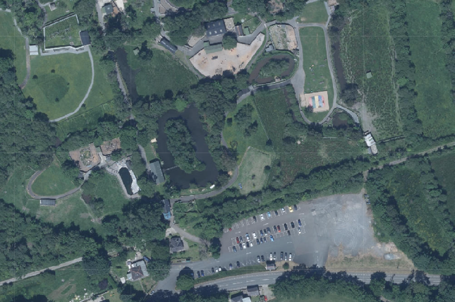
An aerial site plan showing a large paved parking area surrounded by green fields and trees.
1.0 Introduction
1.1 As the site is owned and managed by Department of Environment, Food and Agriculture, and the application, the application should be referred to the Council of Ministers for determination under Article 16 (1)(b) of the Town and Country Planning (Development Procedure) Order 2019 noting that the original application was submitted prior to 1st August, 2024 where an amended Procedure Order was brought into effect.
1.2 The site is part of the car park which serves the Wildlife Park which is situated on the northern side of the A3 TT course and mid way between the settlements of Sulby to the north east and Ballaugh to the south west.
1.3 The Wildlife Park extends to the north of the car park to approximately 17ha (42 acres) in which there are formal animal enclosures, expanses of natural habitat with flora and fauna and pedestrian trails, a cafe, playground, miniature train circuit and various buildings which animals reside within and a small entrance kiosk and shop alongside the car park.
1.4 The car park is separated from the Wildlife Park by vegetation which grows on both sides of the former railway line public footpath. Parking bays are marked on the hard surface and include spaces for disabled users and a bus stop. The car park level falls from the roadway to the north.
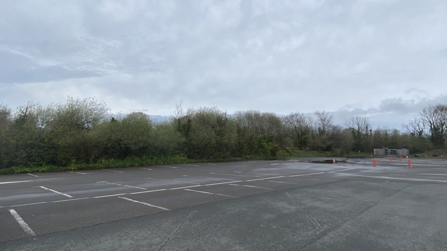
A photograph showing a paved parking area with white bay markings, bordered by a dense line of trees and bushes under an overcast sky.
1.5 The Park is open throughout the year to the public who pay to enter with longer opening times throughout the summer.
1.6 The car park which serves the Wildlife Park is subject to control under the Department for Infrastructure Off-Street Parking Places Order 2023 which allows motor cars, motor cycles, vans and coaches to park at all times without any type of authorisation to be displayed but for no longer than 16 hours in any 24 hour period. The regulations also prohibit people sleeping or living in any vehicle.
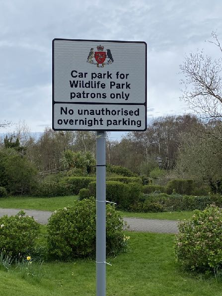
A photograph of a white signpost stating 'Car park for Wildlife Park patrons only' and 'No unauthorised overnight parking' set against a backdrop of greenery and trees.A street-level photograph showing a rural road junction with a stop sign, trees, and buildings in the background.
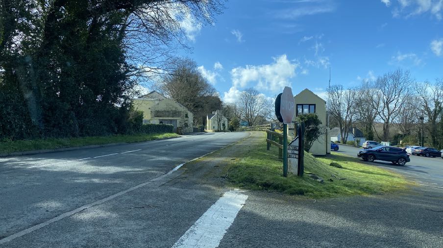
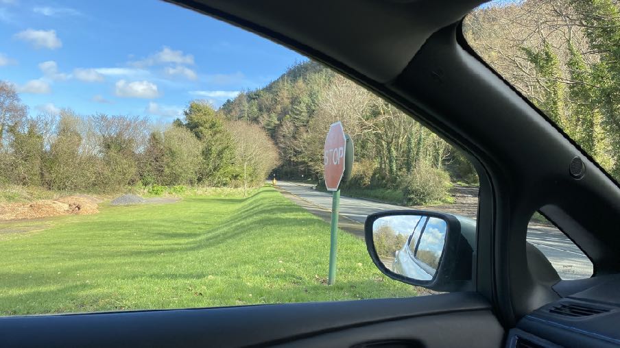
1.7 Access into the site is from a point level with the entrance kiosk with the exit further to the north (see photos below).
1.8 Close to the site are residential properties outwith the applicant’s ownership including Gate Cottage, Hillcrest, Tan-y-Bryn and opposite the site, Rose Cottage.
1.9 This application proposes to permit overnight stays within the car park by up to four motorhomes. As this will involve people sleeping and staying within the car park, it is believed that this represents a material change of use of the car park for which planning approval is required.
A photograph taken from inside a vehicle showing a rural road junction with a stop sign and wooded hillside in the background.
2.0 Planning policy
2.1 Planning policy takes a number of forms: development plans set out what purpose or function land is designated for - land is designated for a particular purpose or not - and these development plans take the form of a variety of adopted Area or Local Plans (or where there is neither, Isle of Man Planning Scheme (Development Plan) Order 1982). Above this, there is the Isle of Man Strategic Plan 2016 which is not geographic but provides overarching strategic policies which apply across the Island. Area Plans should be in general conformity with the Strategic Plan but where there is any contradiction or conflict, whichever was adopted later would prevail (paragraph 1.4.4).
2.2 Consideration can also be given in the determination of any planning application, to Planning Policy Statements, Planning Circulars, National Policy Directives (there is none as yet) or other statements of planning policy as well as other Government policies (Section 10(4) of the Town and Country Planning Act 1999. Planning involves a balance of all of these considerations as well as anything else which could be considered a material consideration. In this case we believe that the Government Economic Strategy (including the Annual Report of December 2023) and the Island Visitor Strategy are both material considerations which should be given weight in the planning balance.
2.3 Isle of Man Planning Scheme (Development Plan) Order 1982
2.3.1 The only adopted development plan for this site is the Isle of Man Planning Scheme (Development Plan) Order 1982. This took the form of an all Island map and a Written Statement which has been superseded by the Strategic Plan.
2.3.2 In a large part of the north and west of the Island, this plan, albeit of a considerable age, remains the only adopted land use document. However, Cabinet Office is in the process of preparing an Area Plan for this remaining area and a draft, and modified draft plan has been published which are to be the subject of a pubic inquiry commencing on 16th July, 2024.
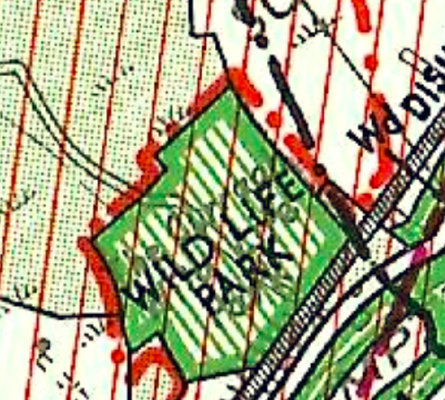
2.3.3 The 1982 Plan designates the Wildlife Park itself as an “Area for Open Space not open to the general public” with the car park as an “area of land owned by the Isle of Man Forestry, Mines and Lands Board or the Government Property Trustees”. All of the area is within an area designated as of High Landscape or Coastal Value and Scenic Significance. This has relevance to Environment Policy 2 (see paragraph 2.5.1) although these areas have
been superseded in the two adopted Area Plans (for the South and East) by the Landscape Character Assessment (see paragraph 2.4.5).
Excerpt from Isle of Man Planning Scheme (Development Plan) Order 1982
A close-up section of a topographical map showing a green shaded area labeled 'WILD LIFE PARK' with red grid lines and boundary markers.
2.4 Draft Area Plan for the North and West
A planning site location map highlighting the Ballaugh Curragh Ramsar Site in green, showing field boundaries and surrounding rural land.
2.4.1 As stated above, Cabinet Office is in the process of preparing an area plan for the remaining parts of the Island which aren’t covered by the Area Plans for the South and East. This plan has progress through the preliminary publicity stage and a draft plan and accompanying documents was published in June 2022. A modified version of these documents was published and a public inquiry was held in July, 2024.
2.4.2 On the most recent iteration of the Proposals Map associated with the Area Plan for the North and West (APNW) the site falls outwith the settlement boundaries and maps for Sulby and Ballaugh
and falls within the much wider area of countryside - that is, land not designated for a particular purpose.
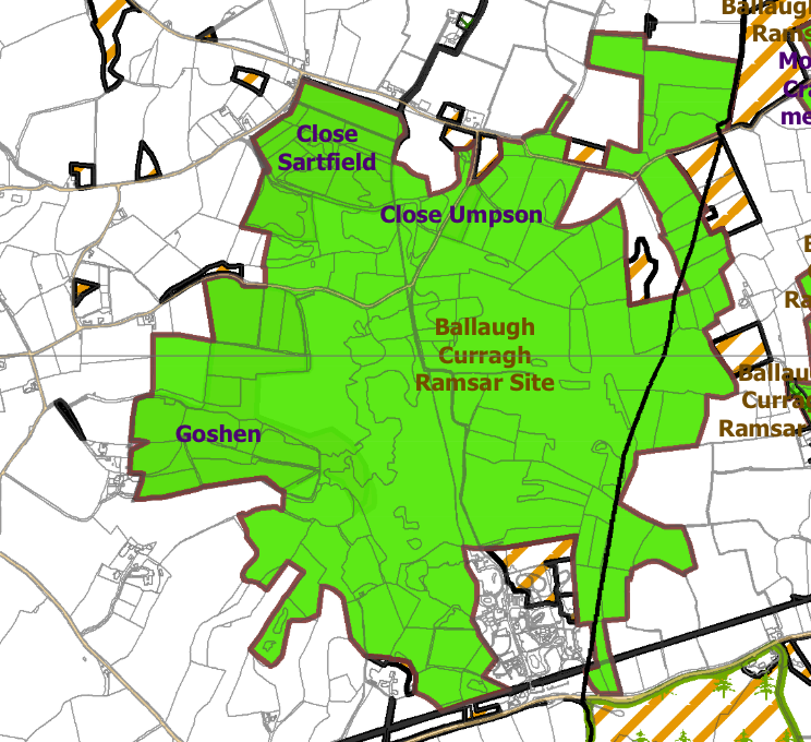
2.4.3 The draft APNW contains additional Constraints maps which identify specific issues relating to certain areas within the plan boundaries. There are no Constraints identified for this site on the Environmental Constraints map although the land to the east and surrounding the main area
within the Wildlife Park is designated as an ASSI and RAMSAR site. RAMSAR indicates a wetland site of international importance and this is the only one on the Island. There are additional Wildlife Sites at the periphery of the ASSI all of which are shown below.
2.4.4 There are high voltage cables shown as running under the former railway line which separates the car park from the Wildlife Park but no other Infrastructural Constraints shown on the relevant map and no indication of any flood risk.
2.4.5 The draft Area Plan incorporates the findings of the Landscape Character Assessment which identifies the site as falling within an area of F6 The Curraghs Undulating Lowland Plain where the following guidance is provided (the full description in the original 2008 Assessment is set out in Appendix One):
Landscape Strategy To conserve and enhance: a) the character, quality, distinctiveness and ecological value of this area as well as managing the area sensitively to accommodate the needs of farmers, tourists and visitors.
Key views
• Views to wooded and non-wooded upland slopes directly to the south of the area.
• Open views across the area are often constrained by woodland; however, views to adjacent farmland can be gained from the north, eastern and western edges of the area.
2.5 Isle of Man Strategic Plan 2016
2.5.1 There is a general presumption against development in undesignated areas, as set out in General Policy 3 of the Strategic Plan (see Appendix One). Environment Policies 1 and 2 presume against development which would be harmful to the character and appearance of the countryside, EP 2 placing even more weight on the protection of the character and quality of the countryside in areas which were identified on the Isle of Man Planning Scheme (Development Plan) Order 1982 as of an area of High Landscape or Coastal Value and Scenic Significance which includes this site.
2.5.2 There are no buildings on the site, Registered or otherwise. The site is not within a Conservation Area. There are no Registered Trees on the site.
2.5.3 The Strategic Plan acknowledges the value of open, undeveloped space:
10.3.2 Open Space forms part of our heritage as well as being an attractive and usable asset, and, in the wider context, provides visual and spiritual relief from the developed urban settlements on the Island. In addition, it provides recreational enjoyment in respect of various active and some less active forms of sporting activity. Open Spaces also provide a means of improving the health and fitness of the Island’s population. Open Space is defined in this context as land used for recreational purposes, both formal and informal, including amenity space whether privately or publicly owned.
2.5.4 Development which would adversely affect the environment is presumed against (Environment Policy 22) and
7.17.2 In addition to the above, changes in the activities associated with the current permitted use of land or a building, which in themselves do not constitute development and therefore do not require planning permission, can have an adverse impact on adjacent properties by virtue of noise, light or general disturbance. For example the addition of security lighting on a property may cause light pollution affecting adjacent properties and the wider area. The introduction of new activities into established parks and recreation areas can have an impact on neighbours. In such cases the Department would advocate the person or organisation considering the change to give careful consideration to the potential impact of such activity in terms of location, siting and design.
2.5.5 Development for the improvement of existing facilities must have regard to any potential adverse impact on those in neighbouring property (Environment Policy 23).
2.5.6 Whilst tourism is not one of the exceptions listed in General Policy 3, Government has an adopted strategy, Our Island, Our Future, which promotes tourism. This document, coupled with the Economic Strategy promote the development of tourism as part of the general objective to build “a secure, vibrant and sustainable future for our Island”. The economic strategy talks of ensuring that the Island’s amenities and leisure facilities are attractive and developing a tourism offering which is more diverse, supports our Island all year round, and is a valued and growing part of our Island’s proposition for both visitors and
residents. It also talks of expanding the availability of facilities and activities for target demographics, in particular improving options for children, young people, and families.
2.5.7 The Tourism Strategy provides a more detailed look at how the industry should be responding to the need for the tourism offer to develop. It specifically refers to the creation of a motorhome stopover network within the Island and clarifies the value of tourist facilities for those visiting the Island as well as those who live on it and may wish to have a break without leaving the Isle of Man. It explains that “The campaign focuses on celebrating the Island’s uniqueness through its ancient and compelling history, and beautiful vibrant landscapes which provide a playground for visitors of all ages, demonstrating the extraordinary experiences available in any season on the Isle of Man.”
3.0 Planning history and relevant applications
3.1 The Wildlife Park has been the subject of a number of applications including ones for the construction of a rolling stock shed for the miniature railway (91/00977/B), a bat house (04/02321/B), an animal hospital and staff facilities (08/01298/B), creation of a car park (10/01634/B), erection of a conservatory extension to the shop (11/01749/B), change of use of the gatehouse to office accommodation (12/00194/C), creation of a pedestrian access from the existing car park (12/00195/B).
3.2 The Wildlife Park is one of a number of Government owned sites which benefits from its own Permitted Development Order. This was introduced in 2012 and allows a range of development within a defined area (which excludes the car park) to be undertaken without the need for a planning application.
3.3 Development which supports the Government’s Visitor Strategy have been considered acceptable where the site was not designated for development and examples of this include Reayrt Vradda in Port Erin (20/00496/B) where a 30 glamping pod/cabin, camping site was approved and is being implemented, and at Broogh Fort (22/01064/B) where an application for change of use from a residential dwelling to three tourist units was initially refused as the site was not designated for development, but permitted on appeal where the inspector noted that:
55. This appeal turns on the acceptability of the proposed conversion with respect to planning policy and Government guidance related to tourism, in the light of the effects of the development on the appearance, character and amenity of the site and surrounding area and any benefits that would accrue as a result of its implementation
56. A wide range of adopted planning policy generally supports proposals for the creation of tourist accommodation by conversion of rural buildings, whilst applying the same level of control over environmental impact as to other forms of development. In this regard I refer to StrP5, BP11-12, BP14 and EP13 of the IMSP noted above.
57. However, StrP8, GP3, EP16 and HP11 of the IMSP together maintain the provisos that such buildings for conversion should be redundant from their previous use, should be of high quality fabric or interest or otherwise occupy
previously developed land or be required for countryside interpretation or in the national interest.
58. First, it is not disputed in this case that the proposed conversion would not qualify in terms of any of these policy criteria or exceptions.
59. At the same time, I consider it equally beyond dispute that, as set out above in the cases of both the Appellant and the Department, the proposed development would have no unacceptably adverse visual, amenity or highway impacts upon the appeal property or on any neighbours or on the wider rural landscape. Therefore, there would be no conflict with the aims of EP1 or GP2 of the IMSP to protect the countryside for its own sake and the environment generally.
60. Moreover, Government guidance, in particular the Tourism Strategy and draft Economic Strategy, supports new tourist accommodation in a more diverse, yearround tourism offer within a growing the Island economy. This appears to have been reflected in the several examples of previous tourism approvals cited by the Appellant.
I have reached the overall conclusion that the lack of planning harm, the positive provision of desirable tourist accommodation and the benefits that would arise due to the development together outweigh any degree of conflict with StrP8, GP3, EP16 or HP11 of the IMSP and justify the approval sought in this case.
3.4 The Department owns and manages a substantial part of the Island and is trying to maximise the use of and benefit from these areas in line with adopted recreation and leisure and tourism strategies. Indeed, the Forestry Act 1984 enables the Department to “lay out, plant and improve any land vested in them, in connection with the use of such land by the public for the purpose of recreation, and in particular erect buildings and carry out works, to provide facilities and services for the enjoyment and convenience of the public, including meals and refreshments, camp-sites, parking places for vehicles, shelters and toilets, and provide facilities and services for open-air recreation”. In this respect it has recently gained planning approval for the parking of catering vans in three of the Island’s plantations. The inspector who considered
the applications reached the same positive conclusion in all cases, making the following comments:
11. However, the accompanying text in Chapter 5 of the written statement which relates to the Natural Environment sets out that the plantations, have significant recreational amenity and there is scope to develop this further. Most of the working forests are open to the public and are popular with walkers, horse riders and cyclists and several are being developed for further recreation purposes through the addition of car parks and other facilities.
47. The proposed change of use would allow for the stationing of a mobile catering facility, the exact nature of which is not yet known, and would depend on the operator appointed to manage the unit. The Applicant has indicated that there are a number of options which would likely include converted vehicles such as vans, horse boxes, caravans and trailers. However, the common denominator would be that it would be a single catering unit and would have to be mobile. I agree with the Planning Authority that the parking of the vehicle would not need permission as the land is a car park. It is the use for business purposes which takes the land use into a different category of use.
48. Whatever the mobile catering unit ends up being, in visual terms, as a parked vehicle it would not be discernible from the other parked vehicles which use the car park. Even if it was parked for longer periods, which is likely over the summer season, as a parked vehicle it would not appear as an unexpected feature within the context of the car park. Therefore, the mobile catering unit would not, in itself, harm the character and appearance of the countryside environment.
49. The use of the unit for the preparation of food and drink and the sale of such items would be small scale and is unlikely to generate customer activity other than in association with the recreational use of the Archallagan Plantation. It would be a facility which may encourage those wishing to enjoy the outdoors, to come to the Plantation knowing car parking is available, as well as somewhere to enjoy a cup of tea or coffee and a sandwich or cake after a walk or ride in the forest. It would facilitate recreational activities by providing refreshments and an opportunity to linger to enjoy the expansive views across the Island and consider the interpretation of the countryside.
50. The proposal would also provide the opportunity for the establishment of a new business supporting growth of employment on the Island.
51. For the reasons set out above it is reasonable to conclude that the proposed change of use for the stationing of a mobile catering unit and the consequential establishing of a business providing refreshments within the Archallagan Plantation car park, would not cause identifiable harm to the countryside environment nor to any other material considerations which might compromise established planning policy and weigh negatively against granting of permission in this instance.
3.5 It should be noted that some of the sites of the catering vehicles are also sites where it is proposed to accommodate overnight parking of motorhomes although the motorhome parking spaces are not in the same parking space within each car park, as will be the catering vehicles. The Wildlife Park car park was not the subject of one of these applications for the installation of these catering vehicles.
4.0 The proposal
4.1 The original application proposed the accommodation of up to ten motorhomes. However, following concern by the planning officer for one of the other applications for motorhome parking, regarding the amount of space afforded to each motorhome parking space and advice from the Isle of Man Fire Service, which has been provided separately, , the proposal has been amended and the application seeks permission for only four overnight motorhome spaces abutting the trees alongside the former railway line, similar to the location of the original application.
4.2 This application, is seeking permission for the overnight accommodation of up to four motorhomes within the site. As this involves people staying on the site, in the vehicles, we believe this represents a material change of use and as such, planning permission is being sought. It should be noted that there is nothing to prevent the overnight parking of any vehicle within the car park (where no-one is remaining in the vehicle) other than the land owner’s own regulations.
4.3 No electric hook ups, toilets or other facilities are being proposed nor any additional lighting as each vehicle is expected to have its own cooking, sleeping, toilet and washing facilities. Anyone intending to stay here would know through the marketing and booking material that there are no facilities on site and if there is a need for recharging, emptying etc, then they would programme their stay so that they will stay at a site where they can do this, before or after their visit to this site, for example at a permanent camp site.
4.4 It is intended that each vehicle will book in advance to stay at the site and may stay for a prescribed period, probably around a maximum of four nights per site during any one stay and the authorised parking period would run between 1800hrs until 0800hrs the following day. The motorhomes could remain in that parking space for all of their four days if they were visiting the Wildlife Park during that time but most are unlikely to do so due to the limited area and lack of facilities and possibly the regulations which apply to each site - in this case vehicles may only remain parked for 16 hours in any 24. It may well be in some instances, those staying on the site might wish to take advantage of the footpath network which is accessible from this site, as well as the Wildlife Park itself with permission from the applicant, so some vehicles could remain in the allocated spaces during the day as well as overnight on some occasions subject to the appropriate regulatory permission as would be the case with any other vehicle parking within the car park.
4.5 It is anticipated that the motorhomes would be parked on this site, as part of a series of stops in other parts of the Island - the network referred to in the Visit IOM’s strategy. The sites would be available for overnight parking throughout the year.
4.6 The allocated parking spaces would be identified through signage rather than surface marking along these lines:
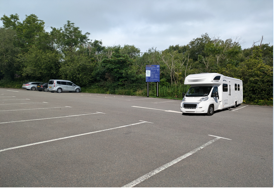
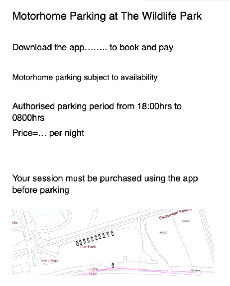
A photograph of a paved parking area with white bay markings, featuring a large white motorhome parked in the foreground and other vehicles in the background near a tree line.The image displays a text notice regarding motorhome parking regulations and fees, accompanied by a small site plan at the bottom illustrating the parking layout and surrounding features.
4.7 Enforcement of the occupation of the spaces would be undertaken through the Infrastructure Off-Street Parking Places Order 2023 as is the current car park.
4.8 Whilst the car park is next to a busy thoroughfare, the parking spaces are positioned as far from the road as is possible and lower than it, providing privacy and some protection from the noise of passing traffic and well as maximum distance from any residential property.
4.9 Monitoring of the appropriate use of these parking spaces would be undertaken by the Department as they currently administer the no overnight parking regulation.
4.10 In terms of impact, it is reiterated that in planning terms, there is nothing to prevent vehicles being parked in this car park overnight, were they unoccupied and these spaces could be occupied by vehicles, including larger vehicles at any time (provided that this was not a permanent use of this site). As such, the visual impact of vehicles parked in this car park is not considered to be such as to warrant refusal of this application.
4.11 Similarly, there is nothing to prevent any vehicle driving into and out of the site at any time and indeed, the capacity of the Wildlife Park is significant, indicated by the size of the car park, and as such, there can be no objection to the application on the basis of highway safety.
4.12 Due to the position of the proposed spaces, it is unlikely that anyone passing the site would notice the parked vehicles or be able to ascertain whether they were occupied or not during the overnight periods.
4.13 Whilst the site itself is relatively isolated, leading to an overnight stay being quiet and close to nature, it is reasonably close to both Ballaugh and Sulby where there are both shops and public houses as well as churches which over night motorhome occupants may utilise.
4.14 The car park accommodates approximately 80 spaces with an additional area to the east which is capable of accommodating additional vehicles if this is required. The motorhome parking is being sought during times when the car park will not be occupied by vehicles of persons visiting the Wildlife Park so there is no issue in respect of any reduction in capacity of the car park for these purposes.
5.0 Response to submissions
5.1 We note the submissions which are critical of the proposals in terms of the lack of facilities. The stopover points are to be exactly that: not fully equipped camp sites which are used exclusively for that purpose and are very different to the various camp sites around the Island which have a range of facilities - electricity, sewage disposal, wet weather facilities, toilet and shower blocks - and are designed for short term stays. They are designed to be used short term as part of a network of sites which offer varying levels of facilities and enable visitors (or locals) to stay in many different parts of the Island with its different offerings of cultural, natural and recreational facilities and attractions and will not detract from these more established and equipped sites but rather will support them as campers may well move on from the stop over sites to more equipped sites to utilise these facilities.
5.2 As such, whilst it is understood that some of the contributors consider that the sites will be less attractive or not desirable if they have no such facilities, this will be demonstrated if the application is permitted and the spaces are advertised and there is either no demand for them or any initial use is not maintained longer term. If this occurs then each site can continue as a parking space to serve the site in or next to which it is located as no physical changes are proposed in any of the cases. The Department is aware that there are many instances of “wild camping” and unauthorised motorhome parking, some of which have adverse impacts on ecology, adjacent neighbours and/or the visual impact of the area, particularly where a large number of campers arrive at one time. This initiative is aimed at providing authorised facilities in areas and in scale that will not result in such impacts on the surrounding areas.
5.3 The test should be whether the proposal is acceptable in planning terms. In the case of the Wildlife Park, the car park is generally not used in the evening after the Park is closed, other than by staff or those associated with deliveries or maintenance of the establishment.
5.4 Concern has been expressed that the occupation of some of the car park by up to ten motorhomes will result in an inability of the car park to accommodate those who wish to visit the Wildlife Park. Please note that the proposal now reduces the number of overnight motorhome parking to four. This is a very real material concern as there is no significant parking space available in the area which could accommodate any overspill and without any safe means of crossing the A3 As stated in the application, the existing car park accommodates 80 marked spaces with additional areas at the eastern part of the site which
could be available was there a need for additional parking spaces. These marked spaces are shown on the additional site plans provided, 03A and 04, along with the large area to the east which is available for additional parking should the need arise. This area is not currently marked out as there has not been a need for this area to be used for parking to date.
5.5 At present the car park accommodates large vehicles, including camper vans, which are parked there on a regular basis. Whilst the car park does not have a segregated area for larger vehicles, there is no issue with the accommodation of larger vehicles whose drivers chose the most appropriate space for their vehicle. Unless those in the motorhome parking space were visiting the Wildlife Park, as with any other vehicles, they would be unable to remain within the car park as part of the management regime of the Wildlife Park, so they will not end up moving or being moved to another space within the car park during the day. The spaces will only be reserved for motorhomes during the hours of 1800 - 0800. There will not, as a result, be a loss of any more than the four spaces proposed.
5.6 In terms of the number of spaces which are regularly used within the car park the car park is not full other than when there is a quarterly event. It might be that those who pay to stay in the spaces are offered a discount on entry to the Wildlife Park, this will be considered if the application is permitted and the proposal is implemented.
5.7 The type of potential signage is shown above although the precise sign will not be designed until after any permission is granted as it will need to be tendered and commissioned. The Department may erect signage without Advertisement Consent under Class 9 of Schedule 1 of the Advertisements Regulations. The Department would have no issue with a condition which requires details of the signs to be provided and approved and their display prior to use and retention as such thereafter.
5.8 If there is a need for the trimming back of the trees and vegetation alongside the motorhome parking area, then this will be undertaken as part of the maintenance of the car park, noting that larger vehicles often park there regardless of the proposed development. None of the trees is Registered so can be trimmed as required by the Department.
5.9 Barbecues will not be permitted and generators not allowed to be operated after 2200hrs. Enforcement will be through the Department’s current system of both staff who are on site and their rangers and wardens who operate throughout the Island.
5.10 It is not intended to have electricity supplies as there is insufficient capacity within the existing supply system and it is not intended that the car park toilets will be accessible during the evening.
5.11 In terms of the impact on residential amenity, the nearest properties are Rose Cottage, Tan-y-Bryn and Hillcrest. Of these, only the owner of Rose Cottage has written in, stating that they do not oppose the application but have concerns over the mains gas line which runs through the site, the impact of heavy vehicles which would use the site, more information on monitoring and management and the condition of the existing toilet block. There is no objection stated on the basis of the proposal per se. It has been suggested by others that the spaces should be relocated to the east of the site, however this area is prone to holding water in times of heavy rain and as such is not suitable for either permanent parking or camping. Whilst this area is available when dry, it would be unfeasible to change the position of the camping spaces depending on the weather.
5.12 It is also relevant that as there are to be four spaces, if there is more than one motorhome on site at any one time, quietness and respectfulness may be self policing.
5.13 In terms of additional bins, the Department will ensure that there is sufficient bin storage available to the users of the spaces and if necessary will provide additional bins for their use. It is emphasised that the spaces are for short term use (up to 4 days and for the evenings not all day).
5.14 All of the above will be communicated to the potential campers when they book the space and the facilities or lack of will be clearly stated so that potential campers are aware of what the site will offer.
5.15 The relevance of the gas main is unclear but the proposal is not on the route of this infrastructure which is laid within the former railway line. This route is used by vehicles, albeit unlawfully.
5.16 There are already heavy vehicles using the entrance for deliveries.
5.17 The monitoring and management of the spaces would be through the Forestry Bylaws and there are staff at the site every day of the year so can manage and enforce motorhomes that stay there longer than the prescribed 4 days or which are there without
the relevant permission or permit. The Department also has a number of rangers and wardens whose responsibilities will be expanded to include these sites.
5.18 In respect of the emptying of waste water into nearby watercourses either directly or indirectly, the Department routinely test the water in the streams and can establish a baseline level to use if there are concerns about waste being deposited therein. The parking requires prior booking so the Department will be aware of and able to contact those who use the spaces if issues arise.
5.19 Concern was expressed that the spaces would not have sufficient area between them and as such the proposal has been amended to provide 6m beside each parked motorhome in accordance with what we believe to be the requirements from the Isle of Man Fire and Rescue Service.
5.20 It is hoped that this clarifies the position in respect of the proposal and satisfactorily addresses the points which have been raised thus far.
6.0 Conclusion
6.1 The site is not designated for development but it is clear from the Strategic Plan and the decisions taken in respect of various applications that tourism development which supports Government Strategy can be considered acceptable for that reason. We would suggest that the application supports the Government’s Tourism Strategy in being part of a network of overnight stops for motorhomes and will not only provides facilities for those who already come to the Island in their motorhomes, but also may attract new motorhome tourists to the Island. It is also possible that local residents who own a motorhome may wish to make use of this network for a holiday or break on Island.
6.2 The recent Government Economic Strategy 2022 - 2032 aims to create a “secure, vibrant and sustainable future” for the Island, “improved health and well being” and By actively investing in key services & infrastructure that attract and retain economically active people, supported by a range of incentives and disincentives to sustain targeted growth” with the Island becoming an even more attractive place to live. These investments include culture, light and transport facilities whilst protecting the natural environment and “expanding and improving facilities and activities for children, young people and families”.
6.3 The application is aimed at providing new visitor facilities and will also support existing camp sites where motorhomes are permitted, enabling visitors to stay in various parts of the Island rather than staying in one location and enabling visitors to experience more of the Island and the attractions it offers. The Visitor Strategy specifically refers to the desirability of establishing a network of motorhome stop over sites.
6.4 We would suggest that there will be no adverse environmental or visual impact as a result of what is proposed and the distance between the proposed spaces and the nearest residential properties, including the main road which separates the car park from Rose Cottage. As such, we would submit that the proposal is not in conflict with any of the policies within the Strategic Plan or any relevant local or Area Plan for this site and will support the Government strategy on promoting tourism on the Isle of Man.
Sarah Corlett 15.11.24
Appendix One
Landscape Character Assessment
F6 THE CURRAGHS Key Characteristics
• Predominantly flat area of wet willow carr woodland, situated on the site of the peat filled Lake Andreas
• Areas of willow and birch woodland, underlain by a diverse wet understorey
• Intricate, damp and shady landscape
• Pockets of traditionally managed meadows
• Curraghs Wildlife Park provides public access and trails through the woodland and other associated habitats
• Strong sense of tranquillity throughout the area, especially at distance from A3
Overall Character Description Situated to the south of Jurby, east of Ballaugh and nestling at the foot of the uplands, this character area encompasses an area of wet woodland and associated habitats. The area is predominantly flat and lies upon the site of the peat-filled Lake Andreas. ‘Curragh’ is a Manx term, which describes an area of ‘wet, boggy, willow wood’ (known elsewhere as willow carr). Landscape within the area, characteristically consists of areas of willow and birch woodland (coppiced in places), underlain by a diverse wet or boggy understorey of ferns, brambles and other damp-thriving flora. These conditions facilitate the creation of an intricate, shady and damp landscape, which provides a diverse habitat for wildlife. The area would previously have been less wooded (open meadow) and was previously also a peat digging area with trenches and ditches. Pockets of the area are traditionally managed as meadows (often exhibiting colourful displays of orchids). The method by which the curragh system is drained is important for management as a wildlife habitat (determining the wetness of the surrounding landscape and hence the types of habitats that it can sustain). The Curraghs Wildlife Park (situated towards the southern edge of the area) provides public access to parts of this landscape, via a number of footpaths and trails. Other than this, one minor road runs through the area, connecting with minor roads to the north and the main A3 to the south. There is a strong sense of tranquillity throughout the area, and views to the directly adjacent uplands and slopes to the south provide recognisable sense of place.
Key Views
• Views to wooded and non-wooded upland slopes directly to the south of the area.
• Open views across the area are often constrained by woodland; however, views to adjacent farmland can be gained from the north, eastern and western edges of the area.
Historic Features
• ‘Ballaugh Curragh is the largest remaining intact example of the distinctive Manx habitat, historically important as a plentiful source of fish, waterfowl and willow, and an important part of the Island's cultural heritage’ (DEFA).
• Manx National Heritage manages much of the site for its wildlife and for public enjoyment, while the Manx Wildlife Trust manages the orchid-rich hay meadows.
Ecological Features
• Area of Special Scientific Interest and RAMSAR site for birds and wildlife.
• Hen harrier roost.
• Traditionally-managed meadows with displays of thousands of orchids.
• Carr woodland and fragmented deciduous woodland in surrounding field boundaries.
• Few vertical elements.
• Very sparse settlement pattern.
• Dramatic views south to Uplands.
• Field pattern delineated by a mixture relatively tall Manx hedge-banks and substantial hedgerows with deciduous trees.
Landscape Strategy The overall strategy should be to conserve and enhance the character, quality, distinctiveness and ecological value of this area as well as managing the area sensitively to accommodate the needs of farmers, tourists and visitors.
Appendix One - policies
Strategic Plan
Strategic Policy 4: Proposals for development must:
(a) Protect or enhance the fabric and setting of Ancient Monuments, Registered Buildings(1), Conservation Areas(2) , buildings and structures within National Heritage Areas and sites of archaeological interest;
(b) protect or enhance the landscape quality and nature conservation value of urban as well as rural areas but especially in respect to development adjacent to Areas of Special Scientific Interest and other designations; and
(c) not cause or lead to unacceptable environmental pollution or disturbance.
General Policy 3: Development will not be permitted outside of those areas which are zoned for development on the appropriate Area Plan with the exception of:
(a) essential housing for agricultural workers who have to live close to their place of work; (Housing Policies 7, 8, 9 and 10);
(b) conversion of redundant rural buildings which are of architectural, historic, or social value and interest; (Housing Policy 11);
(c) previously developed land(1) which contains a significant amount of building; where the continued use is redundant; where redevelopment would reduce the impact of the current situation on the landscape or the wider environment; and where the development proposed would result in improvements to the landscape or wider environment;
(d) the replacement of existing rural dwellings; (Housing Policies 12, 13 and 14);
(e) location-dependent development in connection with the working of minerals or the provision of necessary services;
(f) building and engineering operations which are essential for the conduct of agriculture or forestry; (g) development recognised to be of overriding national need in land use planning terms and for which there is no reasonable and acceptable alternative; and
(h) buildings or works required for interpretation of the countryside, its wildlife or heritage.
Environment Policy 1: The countryside and its ecology will be protected for its own sake. For the purposes of this policy, the countryside comprises all land which is outside the settlements defined in Appendix 3 at A.3.6 or which is not designated for future development on an Area Plan. Development which would adversely affect the countryside will not be permitted unless there is an over-riding national need in land use planning terms
which outweighs the requirement to protect these areas and for which there is no reasonable and acceptable alternative.
Environment Policy 2: The present system of landscape classification of Areas of High Landscape or Coastal Value and Scenic Significance (AHLV’s) as shown on the 1982 Development Plan and subsequent Local and Area Plans will be used as a basis for development control until such time as it is superseded by a landscape classification which will introduce different categories of landscape and policies and guidance for control therein. Within these areas the protection of the character of the landscape will be the most important consideration unless it can be shown that:
(a) the development would not harm the character and quality of the landscape; or
(b) the location for the development is essential.
Environment Policy 3: Development will not be permitted where it would result in the unacceptable loss of or damage to woodland areas, especially ancient, natural and seminatural woodlands, which have public amenity or conservation value.
Environment Policy 4: Development will not be permitted which would adversely affect:
(a) species and habitats of international importance:
(i) protected species of international importance or their habitats; or (ii) proposed or designated Ramsar and Emerald Sites or other internationally important sites.
(b) species and habitats of national importance:
(i) protected species of national importance or their habitats;
(ii) proposed or designated National Nature Reserves, or Areas of Special Scientific Interest; or
(iii) Marine Nature Reserves; or
(iv) National Trust Land.
(c) species and habitats of local importance such as Wildlife Sites, local nature reserves, priority habitats or species identified in any Manx Biodiversity Action Plan which do not already benefit from statutory protection, Areas of Special Protection and Bird Sanctuaries and landscape features of importance to wild flora and fauna by reason of their continuous nature or function as a corridor between habitats.
Some areas to which this policy applies are identified as Areas of Ecological Importance or Interest on extant Local or Area Plans, but others, whose importance was not evident at the time of the adoption of the relevant Local or Area Plan, are not, particularly where that plan has been in place for many years. In these circumstances, the Department will seek site specific advice from the Department of Agriculture, Fisheries and Forestry if development proposals are brought forward.
Environment Policy 22: Development will not be permitted where it would unacceptably harm the environment and/or the amenity of nearby properties in terms of:
i) pollution of sea, surface water or groundwater;
ii) emissions of airborne pollutants; and
iii) vibration, odour, noise or light pollution.
Environment Policy 23: When considering alterations and improvements to existing facilities the Department will require that consideration be given to the potential adverse impact of the proposed changes to existing neighbours.
Copyright in submitted documents remains with their authors. Request removal
Source & Provenance
Official reference
24/00596/C
Source authority
Isle of Man Government Planning & Building Control