Planning Statement In Respect Of The Conversion Of Former Ramsey Bakery To Industrial (Class 2.3), Storage (Class 2.4) And Office Units (Classes 1.2 And 2.1), Station Road, Ramsey Im8 2Lf
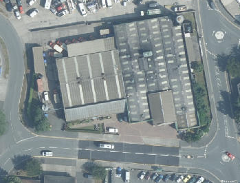
An aerial view of a commercial industrial site showing two large units with parking areas and surrounding roads.
1.0 Introduction
1.1 The site lies to the north of Station Road and in between Bowring Road to the east and Bircham Avenue to the west. The site accommodates a large industrial building which until relatively recently was used by Ramsey Bakery for the processing and manufacture of baked products mostly for the local market. Ramsey Bakery is no longer in operation.
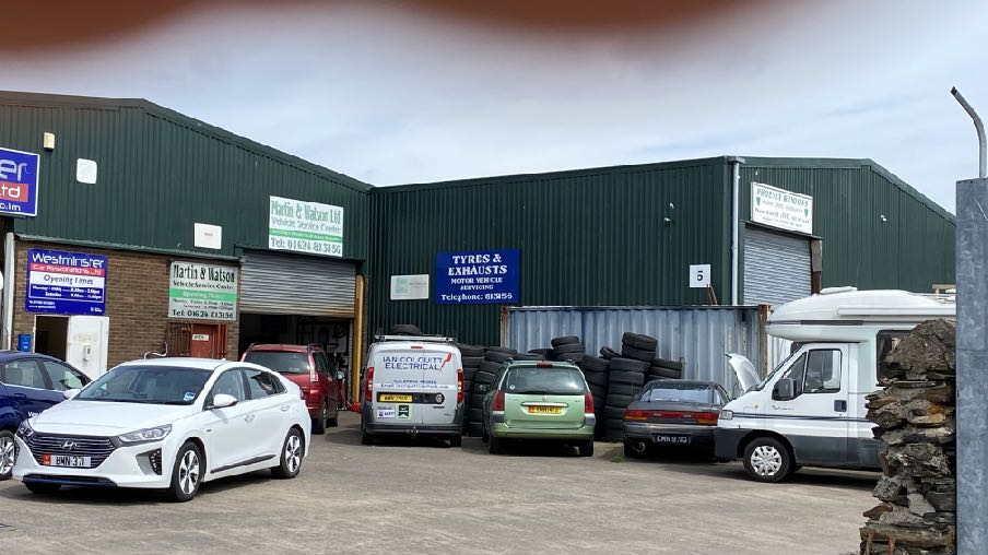
1.2 The site lies to the north of the Shoprite supermarket and public car park and the Ramsey Fire Station: to the south of a number of industrial units including Haldane Fisher, Westminster Car Restorations Ltd, Martin & Watson Vehicle Service Centre, Tyres and Exhausts and Phoenix Windows.
1.3 The site of the former bakery was originally Ramsey steam railway station.
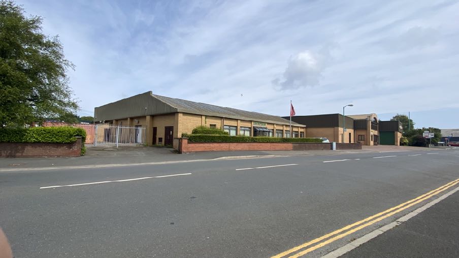
1.4 The building accommodates a large internal space which was formerly used for the baking and packaging of bread and bread products together with associated administrative and staff facilities. The frontage onto Station Road includes a glass entrance porch, ground floor windows and towards Bowring Road, taller industrial sections of the building, all finished in light coloured facing brickwork at ground floor and the taller elements in brown cladding.
1.5 There is some car parking in front of the building off Station Road as well as an area of landscaped space in front of the entrance. Around the side, off Gladstone Avenue the building
A street-level photograph showing a single-story commercial building with a brick facade and pitched roof, situated along a road with double yellow lines.
becomes more industrial in appearance, with a detached store building but separated from the road by a short grass strip with two small trees.
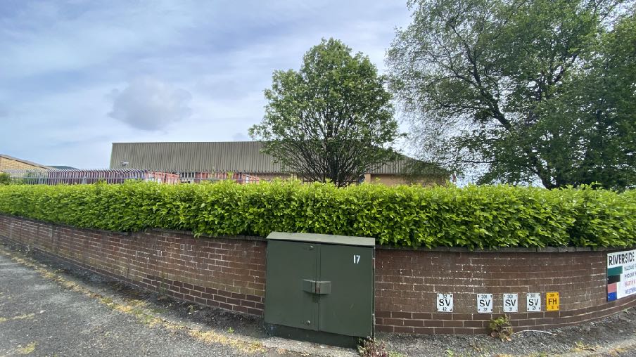
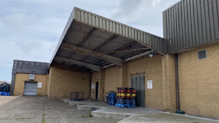
A street-level photograph showing a brick boundary wall topped with a green hedge, with a large industrial-style building visible in the background.A photograph showing the exterior of a commercial building featuring a large corrugated metal loading bay canopy and concrete apron.
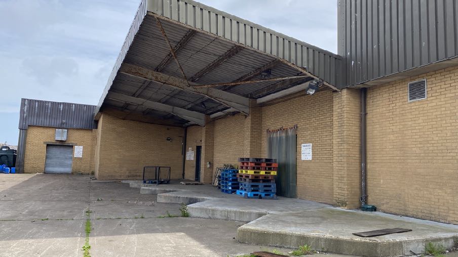
1.6 The rear of the site and the building is wholly industrial in nature with a raised concrete delivery area adjacent to the rear roller shutter doors.
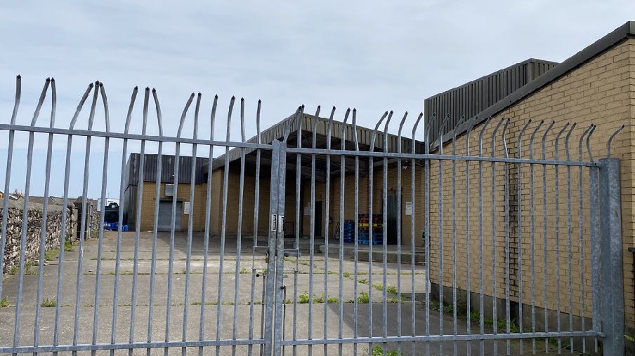
1.7 There are three means of vehicular access into the site: two accesses off Station Road - one leading to the parking in front of the entrance and the other leading to the south western side of the building and a third access off Gladstone Avenue. The latter two have security gates.
A photograph showing a single-story brick industrial building viewed through a metal security fence with anti-climb spikes.
2.0 Planning policy
2.1 The starting point for the determination of any development proposal is the land use designation. The most recent Area Plans cover a large part of the Island and there are adopted plans for the south and east. The remainder of the Island (the north and west) is the subject of an Area Plan which is in the process of preparation and is currently in draft form. The adopted development plan for this part of the Island is the Ramsey Local Plan which, if the draft Area Plan for the North and West is adopted, will be superseded by it.
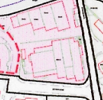
2.2 The site lies within an area designated on the Ramsey Local Plan adopted in 1999, as Light Industrial. The Local Plan is the only adopted development plan for this site (below left):
Ramsey Local Plan Written Statement
2.3 This contains policies which acknowledge the industrial area between Station Road and the Sulby River and talks of developing the land to the west as part of a development brief although this does not appear to include the site. This and the West Ramsey Development Framework identify the site as existing industrial land and staying as such.
2.4 Unlike the land to the west, the site is not subject to any particular policies in the Written Statement (shown by the red dashed line top right). The site lies outside the town’s Conservation Area and no buildings on or near the site are Registered.
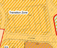
Draft Area Plan for the North and West
2.5 On the draft Area Plan for the North and West, the site is designated, somewhat unhelpfully not for a particular use but as a “Transition Zone” (above right). One has to look into the Written Statement to try to understand what this means and here it states:
This image displays a site plan or block plan illustrating the layout of buildings and property boundaries for a planning application.A cropped section of a planning map displaying a designated 'Transition Zone' with hatched boundaries and road layouts.
9.3.3 Transition zones between primary town centre uses and quieter residential areas also have a role to play in respect of future opportunities for growth.
9.10 The Transition Zones
9.10.1 The transition zones incorporate a mix of uses generally on larger floorplates (or coarse grained) adjacent to the town centre that support the principle town centre uses. Transition zones help to provide a buffer between quieter residential areas and the livelier town centre uses that extend into the evening. They also present opportunities for business expansion adjacent to the existing town centre, where larger floor plates are needed.
9.10.2 Within Ramsey, transition zones are located within areas encompassing St. Pauls Square (including the Shoprite supermarket), the MER Station, a large area incorporating the Co-op supermarket, bus station and former Raymotor’s Garage, and the Shoprite supermarket, Fire Station, former Ramsey Bakery and Ramsey Town Commissioners’ Yard. Transition zones in Ramsey are characterised by anchor retail uses and bulky goods retail, transport facilities and car parking, petrol stations, civic and industrial uses and private dwellings.
9.10.4 Future development proposals within the transition zones should complement town centre uses, but not replace them. In some instances, development parameters may be set out in the form of a Development Brief or a Regeneration Strategy, to guide the future redevelopment of a transition zone.
9.10.5 In respect of the proposed Comprehensive Treatment Area (CTA) in Ramsey, a succinct Development Brief has been included in Chapter 8. A feasibility report will be prepared in the future that sets out more detailed information in respect of the site opportunities and challenges that are presented at this key gateway into Ramsey town centre from the North.
Town Centre Proposal 9: The Transition Zones
1. A mix of uses (some with larger floorplates) with good links to the historic core that contribute positively to the townscape will be supported. Acceptable land uses include civic land uses, leisure uses, bulky goods retailing and public transport hubs;
2. The re-use of previously developed sites in transition zones is encouraged, in accordance with development parameters set out in any future Development Brief or
regeneration strategy alongside Strategic and Area Plan policy guidance. Vacant premises should be brought back into re-use;
3. Future re-development in the transition zones should be of high design quality and integrate well with both the historic core and residential hinterland, whilst providing natural surveillance on to the street;
4. Attractive boundary treatments that help to restore a sense of the original street enclosure will be supported and views of rear properties should be screened from view;
5. Future investigation of/provision for park and ride facilities, cycle parking infrastructure and electric vehicle charging points is supported. Car and cycle parking areas should incorporate green infrastructure elements within the transition zones, to positively contribute to townscape quality and biodiversity enhancement.
2.6 The site also lies within a Comprehensive Treatment Area and here the draft Area Plan Written Statement includes some clarification of what this means:
Built Environment Proposal 1: Urban Regeneration The Area Plan supports regeneration within our urban settlements generally but particularly supports regeneration in the following locations: 1. The Fire Station, Shoprite Supermarket and West Quay, Ramsey – for office, leisure, retail, hotel, residential, entertainment venues, food and drink uses and public open space or a combination thereof. Emergency services provision on the site opposite the existing Fire Station will also be supported…
Urban Environment Recommendation 1
For Government owned land in the North and West which is vacant or underused, it is recommended that Departments work together with the Manx Development Corporation to clarify issues including strategic approach, preferred uses, funding mechanisms, timing, which should include a focus on townscape and public realm improvement and connectivity in line with the Vision set out in this Plan. The achievement of co-operation and skills development will assist in the process of optimising the potential of all vacant and underused sites and delivery of high quality schemes on site.
8.15 Comprehensive Treatment Area – West Quay and Sulby River, Ramsey (area is shown on Maps 4 and 5)
8.15.1 Land within West Quay and overlooking the Sulby River is very visible on approach to the town centre over the Stone Bridge. Despite planning approval for a variety of uses
having been granted, much of the site remains undeveloped and has done for some time. The site has a negative effect on this prominent area of Ramsey Harbour and impacts on the appearance of the town as a whole.
8.15.2 The area fronting onto the harbour should be sympathetically developed in a manner that respects the historic building line, scale and massing. Current land uses within the industrial site next to the Stone Bridge, incorporating the Ramsey Town Commissioners Depot, could be rationalised to include combined emergency services provision. There may be future opportunities to look at the design/position of the existing Shoprite supermarket site in a manner that restores the original sense of enclosure to the street scene, and introduces replacement residential properties on the site of the existing Fire Station Site.
8.15.3 West Quay, Ramsey is a strategic freight corridor and maintaining access for commercial vehicles, including HGV’s, must be considered in any proposed development. A Development Brief has been prepared to set out development parameters for future development in this area, as detailed below.
8.15.4 The 1999 Act prescribes under S.4(2) that: “If an area is designated under this section by an area plan, the plan shall:
(a) describe the treatment which is proposed by the Cabinet Office; and
(b) specify the period, which shall not exceed 5 years beginning with the date on which the plan is adopted, within which that treatment is to begin.”
Built Environment Proposal 2 - CTA Proposal for West Quay and Sulby River, Ramsey (Treatment Plan)
Development of this area shall include office, leisure, retail, hotel, residential, entertainment venues, food and drink uses and public open space or a combination thereof. Emergency services provision on the site opposite the existing Fire Station will also be supported if this is deemed a practical change in service provision.
All new development and regeneration proposals within the Comprehensive Treatment Area must demonstrate design elements to provide and enhance areas of public realm through sensitive and context-specific design.
Within 12 months of the date when this plan is adopted, the Cabinet Office shall publish a broad feasibility study for the CTA reflective of this Proposal (the Development Brief below) and other Proposals in this plan which seek to improve townscape and achieve
the optimum use of brownfield sites in existing settlements. The minimum details shall include:
i. A site context and existing conditions plan, showing levels at the appropriate local datum, existing land uses and building footprints, adjoining roads and access points and land in government ownership.
ii. Detailed analysis of the issues and identification of possible solutions/options going forward.
iii. An exploration of whether any areas of the CTA which may need to be master planned.
iv. An exploration of the feasibility of connecting this area via a new ‘over river’ link/ walkway/bridge to the area close to North Shore Road/Bowring Road junction.
Where land is designated a ‘CTA’, Cabinet Office may acquire that land or any part thereof by agreement or compulsorily to facilitate treatment by development, redevelopment or improvement.
Development Brief for area defined as ‘CTA Proposal for West Quay and Sulby River’
1. This area is considered suitable for civic land uses, tourism or leisure uses, professional and financial service uses, food and drink, residential land uses and bulky goods retailing; open spaces and improved public realm and circulation space for vehicles and people actively travelling.
2. Active ground floor uses are encouraged at ground floor levels to take advantage of key views towards the waterfront and Sulby River. Residential and tourist accommodation uses, together with professional and financial service uses are encouraged shall be considered possible uses in upper storeys of buildings to take advantage of key views towards the waterfront and Sulby River.
3. Development proposals in this area going forward must should be accompanied by a Design Statement that sets out the baseline site characteristics and identifies distinctive townscape elements and natural features that form part of the character of the area, and identifies suitable design approaches that can build upon this distinctive townscape. Any Design Statement shall take into account this Plan and any Feasibility Study published by Cabinet Office in line with BE Proposal 2 set out above.
4. Based on the townscape studies undertaken, the storey heights of new buildings – subject to final detailed design – should be limited to a maximum of four storeys on West Quay - overlooking the harbour, dropping down to three storeys in height overlooking
the River, and then dropping down to two storeys in height towards the residential hinterland.
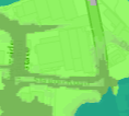
A low-resolution site location map showing green land parcels, road networks, and a body of water in the corner.
2.7 The Area Plan also contains maps which illustrate various types of constraint - environmental and infrastructural. There are no Environmental Constraints applicable to this site.
2.8 The Infrastructure constraints include the identification of the site as within an area at risk of tidal flooding (see green colouring below taken from the national flood risk mapping). This area extends much further south than the site.
2.9 There are no trees, Registered or otherwise, on the site and the building on the site is not Registered, the nearest Registered Building being the Courthouse referred to above.
2.10 The draft Area Plan for the North and West recognises the importance of Ramsey as a Service Centre, second only to Douglas in the settlement hierarchy in the Strategic Plan (see later) where development will be concentrated in the north of the Island. The overall issues for Ramsey Town Centre are stated in the draft plan as being:
1. How to respect and maintain the interactive relationships between the working harbours, the quay side businesses and town centre uses;
2. How best to define the ‘town centre’;
3. Strengthening the High Street and maintaining vibrant centres;
4. Creating attractive places where people want to and can: spend time, live, shop, work and easily move around;
5. Optimising the use of our centrally located sites which are vacant or underused and in a poor state of repair;
6. How to deal with flood risk in coastal locations which are seeing more regular and severe storm events as a result of climate change.
2.11 Development of unoccupied sites is encouraged at paragraph 8.6.3:
Comparably high building densities within the town limit the options for infill development to meet housing need, but the 2021 Census shows a high property vacancy rate of 16% and quayside buildings have become un-occupied in some areas. Bringing un-occupied sites and buildings back into re-use will benefit the local economy, enhance the townscape quality and increase the available number of residential dwellings.
2.12 The “Overview of Ramsey” explains at paragraph 9.3.1 that:
This Plan presents practical and sensible proposals for Peel and Ramsey and the other settlements in terms of their centres, however those centres are defined. It addresses local issues and puts forward clear and positive proposals that respond to those issues that affect each town centre. This Plan ensures a town centre focussed approach that will help to attract high quality investment and strengthen confidence and a will to develop and occupy sites. The opportunity has been taken to identify ‘mixed use zones’ as a planning tool to guide and protect development types.
9.3.4 Ramsey - The town centre in Ramsey is vulnerable to flood risk, particularly along the East Quay. Under-investment in quayside buildings has resulted in vacant properties and underoccupied urban sites that mar the public face of Ramsey. Consequently, there is a need for regeneration of these sites, together with sympathetic flood risk alleviation measures and public realm improvements, so as to enhance the public face of the town centre and bolster the local economy.
9.3.5 Setting out Town Centre Mixed Use Areas in Ramsey, defining a town centre boundary and providing suitably worded Town Centre Proposals provides a focus for both public and private sector investment and support a variety of uses that allows for greater flexibility to better respond to changing market demands. Providing greater flexibility of uses can be used as a mechanism to support viable regeneration initiatives in those areas where it is desirable to encourage regeneration, and to bring vacant premises back into commercial use, thereby enhancing the public face of the town.
2.15 The Strategic Plan sets out generally non-geographic policies which apply Island wide. There is a general encouragement of sustainable development which is directed to established settlements (Strategic Aim, Strategic Policies 1, 2 and 10, Spatial Policy 5 and Housing Policy 4) with Ramsey being one of the five Services Centres which will provide regeneration and choice of location for housing, employment and services (Spatial Policy 2).
2.16 The design and appearance of development should be appropriate and of a high quality (Strategic Policies 3 and 5 and Environment Policy 42).
2.17 Development in areas designated for development is generally supported, provided that it complies with the following general standards of development:
General Policy 2: Development which is in accordance with the land-use zoning and proposals in the appropriate Area Plan and with other policies of this Strategic Plan will normally be permitted, provided that the development:
(a) is in accordance with the design brief in the Area Plan where there is such a brief;
(b) respects the site and surroundings in terms of the siting, layout, scale, form, design and landscaping of buildings and the spaces around them;
(c) does not affect adversely the character of the surrounding landscape or townscape;
(d) does not adversely affect the protected wildlife or locally important habitats on the site or adjacent land, including water courses;
(e) does not affect adversely public views of the sea;
(f) incorporates where possible existing topography and landscape features, particularly trees and sod banks;
(g) does not affect adversely the amenity of local residents or the character of the locality;
(h) provides satisfactory amenity standards in itself, including where appropriate safe and convenient access for all highway users, together with adequate parking, servicing and manoeuvring space;
(i) does not have an unacceptable effect on road safety or traffic flows on the local highways;
(j) can be provided with all necessary services;
(k) does not prejudice the use or development of adjoining land in accordance with the appropriate Area Plan;
(l) is not on contaminated land or subject to unreasonable risk of erosion or flooding;
(m) takes account of community and personal safety and security in the design of buildings and the spaces around them; and
(n) is designed having due regard to best practice in reducing energy consumption.
2.18 Sustainable development which reduces journeys and energy use and increases thermal efficiency is now encouraged (Residential Design Guide (which also gives advice about design) and Climate Change Act 2021).
2.19 Existing buildings can often be converted to multiple apartments provided that certain criteria are met and which also relate to new proposals for apartments (Housing Policy 17 and Strategic Policy 12).
2.20 Development is expected to optimise/make the best use of sites (Strategic Policy 1).
2.21 Development should make adequate provision for car parking (Transport Policy 7 and General Policy 2). Parking standards are set out in Appendix Seven of the Strategic Plan and generally require light industrial development to provide one space per 30 sq m nett floorspace; storage and distribution 1 space per 100 sq m gross floorspace and for general industrial one space per 50 sq m gross floorspace. In town offices should provide one space for every 50 sq m nett of floorspace. All of these standards may be relaxed in a town centre location within a reasonable distance of an existing or proposed bus route where it can be demonstrated that there would not be unacceptable on street parking as a result.
2.22 Development which would be at or increase unacceptable risk of flooding is presumed against (Environment Policies 10 and 13).
3.0 Planning history
3.1 The planning history of an area can give an insight into what has previously been considered acceptable and unacceptable and provided there has been no change of circumstance or policy since then, the same conclusion should be reached in any future development proposals.
3.2 In this case the bakery was approved as a brand new bakery in the 1970s and has had a series of extensions and alterations over time, the most recent being the addition of a flour silo in 2003.
3.3 To the rear, permission was granted for the demolition of Ramsey Cycles on Bowring Road and its replacement by a storage compound which is now used by Haldane Fisher builders’ merchants. The units in this row have been in situ for at least 40 years.
4.0 The proposal
4.1 The proposal seeks permission for the conversion of the existing building and site to predominantly industrial use with a small area of offices and with the central units to be used for storage. The relative areas are:
Office use 100 sq m Storage 935 sq m General industrial 1072 sq m
4.2 The site is currently laid out to serve a single user and as such, the parts of the building which face east and north have limited space for access. As such, to enable these parts of the building to have adequate access, a section of the northern part of the existing building is to be removed so that these parts of the building will have access - vehicular and pedestrian.
4.3 In total, 36 spaces will be provided which equates to more than the required amount (2 spaces for the offices, 10 spaces for the storage area and 22 spaces for the industrial floorspace).
4.4 A small area of grass on the western side of the site is to be removed to facilitate a better arrangement of parking spaces here and the stepped loading bays will be removed at the rear of the
A photograph showing the exterior of a yellow brick industrial building with a large corrugated metal loading bay canopy and stacked pallets.
site. A very small area of planted border in front of the front entrance will be removed to better accommodate vehicular turning in this part of the site.
4.5 The existing brick building abutting Poylldooey Road will be used for the storage of bicycles.
4.6 The existing area between the eastern elevation and the road which is grassed with existing trees and shrubs will be retained with additional planting to enhance what has become a wildlife area where waxwings are a common sight when they come to the Island at the start of winter.
4.7 Internally, there will be a new mezzanine area over the self storage with additional storage areas provided at this half level alongside the existing first floor mezzanine accommodation.
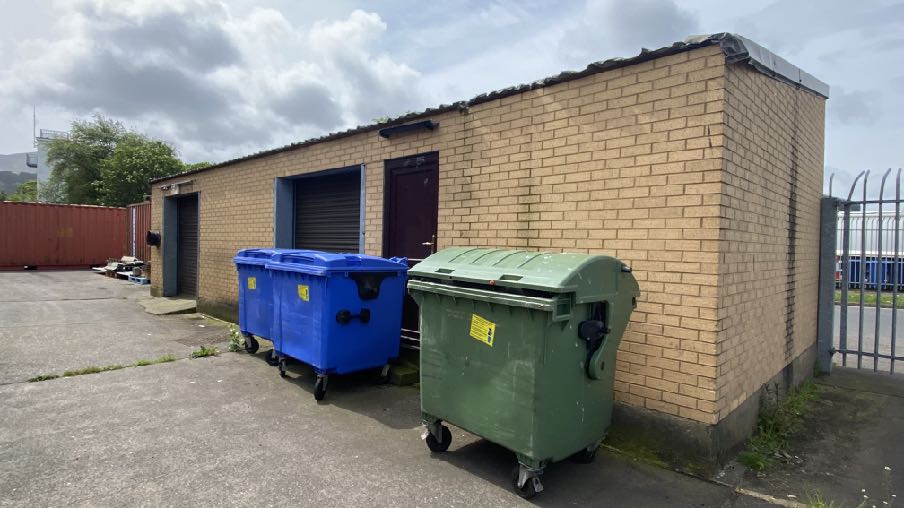
Exterior photograph of a single-story yellow brick building featuring roller shutter doors and large waste bins in a paved yard.
5.0 Assessment and summary
5.1 The site is located within a settlement, in a sustainable location close to existing public transport links and is designated for Light Industrial on the adopted development plan and somewhat more vaguely in the emerging Area Plan as a Transition Zone where a wider range of uses appears to be accepted. The site has a serviceable building on it with all services provided, three means of access and car parking. There should therefore, be a presumption in favour of development here and the best use of the site. The principal issues are considered to be:
•The impact from and on flood risk from any new use or any intensification of use of the site
•Car parking and highway safety
•Impact of the proposal on adjacent users
5.2 Flood risk
5.2.1 The site lies within an area at high risk of tidal flooding although the building exists and may be used for purposes which accommodates people, vehicles and activities without the need for any further planning approval (if it were to continue to be used as a bakery). A Flood Risk Assessment has been commissioned from Axis Consulting Engineers and is provided with the application.
5.2.2 The FRA describes the existing ground floor level as being at 5.290m, compared with the tidal flood levels for a 1 in 200yr flood event, which are 5.640m. As the building exists and modification of the ground floor level would be difficult, a series of passive flood protection measures are proposed around the site.1m flood boards are proposed to be provided across all thresholds: these provide a 650mm freeboard which exceeds the 600mm allowance. These boards will be capable of being deployed at short notice.
5.2.3 Within the building sockets and fuse boxes will be raised by 1m providing a 650mm freeboard above flood levels. Consideration will be given to the installation of non return valves on the foul drainage system to prevent reverse head occurring during extreme tidal events. As well, consideration will be given to the installation of automated sump pumps within the building which may be activated if the primary defence systems are partially breached.
5.3.4 A flood evacuation plan will be put into place noting that 12hr flood warnings can be provided by the Met Office.
5.2.5 The proposal will reduce the amount of floorspace which is at ground floor level, therefore reducing areas more susceptible to flood damage.
5.3 Car Parking
5.3.1 The bakery generated a requirement for parking for its delivery vehicles, its staff and for items being delivered to the premises. What is proposed reduces the available industrial floor area whilst increasing the amount of parking on the site such that it provides the amount of parking required by the Strategic Plan in respect of general industrial office and storage space. Discussions with the Highway Services Division of Department for Infrastructure prior to the submission of the application have resulted in the layout of the site being acceptable in highway safety terms.
5.4 Impact on adjacent users
5.4.1 The site sits alongside a range of industrial uses including window manufacture, car repairs and a builder’s merchants. The continued use of this site for general industrial use is therefore considered to be acceptable in this context. The proposal reduces the amount of usable industrial floorspace whilst increasing the amount of parking on the site and otherwise maintaining the existing access to and from the site.
5.5 Other matters
5.5.1 The draft Area Plan would appear to suggest that the site could be used for purposes other than light industry, where such uses form an acceptable transition from the intensive town centre uses to the residential areas further from the centre of the settlement. Uses referred to include civic land uses, leisure uses, bulky goods retailing and public transport hubs, office, retail, hotel, residential, entertainment venues, food and drink uses and public open space or a
A photograph showing the exterior of a green industrial unit with vehicle service signs and several cars parked in front.
combination thereof. The status of the emerging plan is less than the adopted plan as it has not yet been the subject of independent scrutiny through a public inquiry or Tynwald approval.
5.5.2 This is a highly sustainable, brownfield site where development of almost all kind should be directed and permitted. This is emphasised by the Comprehensive Treatment Area designation in the draft Area Plan. The site is presently surrounded by a car park, fire station and industrial uses.
5.5.3 Whilst there is a requirement for car parking, the building exists and has a parking demand at present, but is within the town centre where there are other forms of transport and where walking and cycling would be possible to and from other amenities and facilities. In any case, the proposal satisfies the requirement for parking spaces
5.5.4 We would submit that this proposal will repurpose a sound building in a highly sustainable location in a manner which will retain and potentially increase employment opportunities in the primary settlement in the north of the Island in accordance with Spatial Policy 2 and incorporating appropriate flood protection measures to enhance flood protection for users of the building.
Sarah Corlett
07.03.2024
Appendix One
Relevant Strategic Plan policies
Strategic Aim: To plan for the efficient and effective provision of services and infrastructure and to
direct and control development and the use of land to meet the community’s needs, having particular regard to the principles of sustainability whilst at the same time preserving, protecting, and improving the quality of the environment, having particular regard to our uniquely Manx natural, wildlife, cultural and built heritage.
Strategic Policy 1: Development should make the best use of resources by:
(a) optimising the use of previously developed land, redundant buildings, unused and under-used land and buildings, and reusing scarce indigenous building materials;
(b) ensuring efficient use of sites, taking into account the needs for access, landscaping, open space(1) and amenity standards; and
(c) being located so as to utilise existing and planned infrastructure, facilities and services.
Strategic Policy 2: New development will be located primarily within our existing towns and villages, or, where appropriate, in sustainable urban extensions(2) of these towns and villages. Development will be permitted in the countryside only in the exceptional circumstances identified in paragraph 6.3.
Strategic Policy 3: Proposals for development must ensure that the individual character of our towns and villages is protected or enhanced by:
(a) avoiding coalescence and maintaining adequate physical separation between settlements; and
(b) having regard in the design of new development to the use of local materials and character.
Strategic Policy 4: Proposals for development must:
(a) Protect or enhance the fabric and setting of Ancient Monuments, Registered Buildings(1), Conservation Areas(2) , buildings and structures within National Heritage Areas and sites of archaeological interest;
(b) protect or enhance the landscape quality and nature conservation value of urban as well as rural areas but especially in respect to development adjacent to Areas of Special Scientific Interest and other designations; and
(c) not cause or lead to unacceptable environmental pollution or disturbance.
Strategic Policy 5: New development, including individual buildings, should be designed so as to make a positive contribution to the environment of the Island. In appropriate cases the Department
will require planning applications to be supported by a Design Statement which will be required to take account of the Strategic Aim and Policies.
Strategic Policy 10: New development should be located and designed such as to promote a more integrated transport network with the aim to:
(a) minimise journeys, especially by private car;
(b) make best use of public transport;
(c) not adversely affect highway safety for all users, and
(d) encourage pedestrian movement.
Spatial Policy 2: Outside Douglas development will be concentrated on the following Service Centres to provide regeneration and choice of location for housing, employment and services Ramsey - Peel - Port Erin - Castletown - Onchan
Area Plans will define the development boundaries of such centres so as to provide a range of housing and employment opportunities at a scale appropriate to the settlement.
Spatial Policy 5: New development will be located within the defined settlements. Development will only be permitted in the countryside in accordance with General Policy 3.
General Policy 2: Development which is in accordance with the land-use zoning and proposals in the appropriate Area Plan and with other policies of this Strategic Plan will normally be permitted, provided that the development:
(a) is in accordance with the design brief in the Area Plan where there is such a brief;
(b) respects the site and surroundings in terms of the siting, layout, scale, form, design and landscaping of buildings and the spaces around them;
(c) does not affect adversely the character of the surrounding landscape or townscape;
(d) does not adversely affect the protected wildlife or locally important habitats on the site or adjacent land, including water courses;
(e) does not affect adversely public views of the sea;
(f) incorporates where possible existing topography and landscape features, particularly trees and sod banks;
(g) does not affect adversely the amenity of local residents or the character of the locality;
(h) provides satisfactory amenity standards in itself, including where appropriate safe and convenient access for all highway users, together with adequate parking, servicing and manoeuvring space;
(i) does not have an unacceptable effect on road safety or traffic flows on the local highways;
(j) can be provided with all necessary services;
(k) does not prejudice the use or development of adjoining land in accordance with the appropriate Area Plan;
(l) is not on contaminated land or subject to unreasonable risk of erosion or flooding;
(m) takes account of community and personal safety and security in the design of buildings and the spaces around them; and
(n) is designed having due regard to best practice in reducing energy consumption.
Environment Policy 10: Where development is proposed on any site where in the opinion of the Department of Local Government and the Environment there is a potential risk of flooding, a flood risk assessment and details of proposed mitigation measures must accompany any application for planning permission. The requirements for a flood risk assessment are set out in Appendix 4.
Environment Policy 13: Development which would result in an unacceptable risk from flooding, either on or off-site, will not be permitted.
Environment Policy 42: New development in existing settlements must be designed to take account of the particular character and identity, in terms of buildings and landscape features of the immediate locality. Inappropriate backland development, and the removal of open or green spaces which contribute to the visual amenity and sense of place of a particular area will not be permitted. Those open or green spaces which are to be preserved will be identified in Area Plans.
Transport Policy 7: The Department will require that in all new development, parking provision must be in accordance with the Department’s current standards.
Copyright in submitted documents remains with their authors. Request removal
Source & Provenance
Official reference
24/00304/B
Source authority
Isle of Man Government Planning & Building Control