Planning Statement In Support Of The Demolition And Replacement Of 6 And 8, Bridge Road With Two New Buildings Accommodating Class 1.1 And Class 1.3 Uses At Ground Floor With Seven Apartments (Class 3.4) Above, Douglas Im1 5Ag
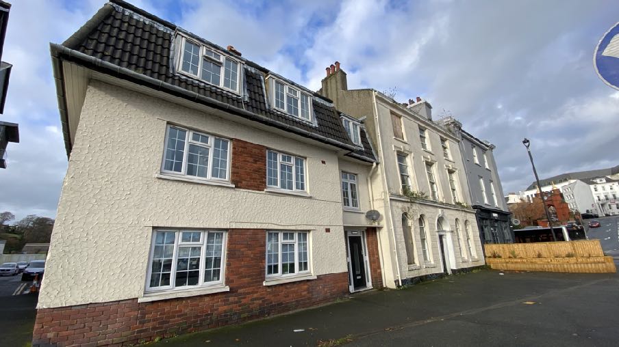
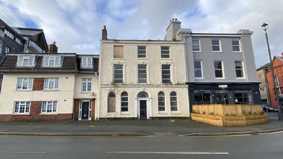
A street-level photograph showing the existing buildings on the site, featuring a white rendered building with dormer windows adjacent to older terraced structures with arched ground-floor windows.
1.0 Introduction
1.1 6 and 8, Bridge Road are two conjoined buildings which front onto Bridge Road and which look east over Douglas Inner Harbour. Number 8 is semi-detached with a single vehicle width lane to the south which has double yellow lines along its length: number 6 is a mid terrace building with the Railway Hotel attached to the north.
1.2 The properties each have a small rear yard area with a currently open area to the rear of number 8 following the demolition of a former warehouse building. There is a further warehouse to the rear of number 6.
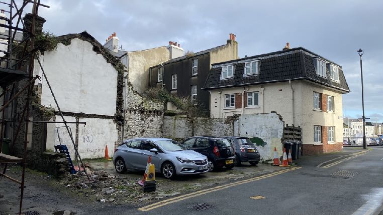
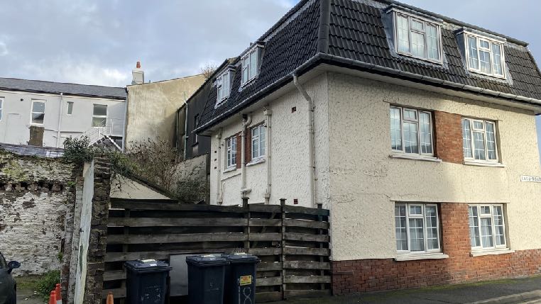
A street-level photograph showing a partially demolished building with exposed brickwork and scaffolding on the left, adjacent to a standing white residential building with parked cars in front.A street-level photograph showing an existing two-story building with white rendering and a dark tiled roof, viewed alongside a wooden fence and waste bins.
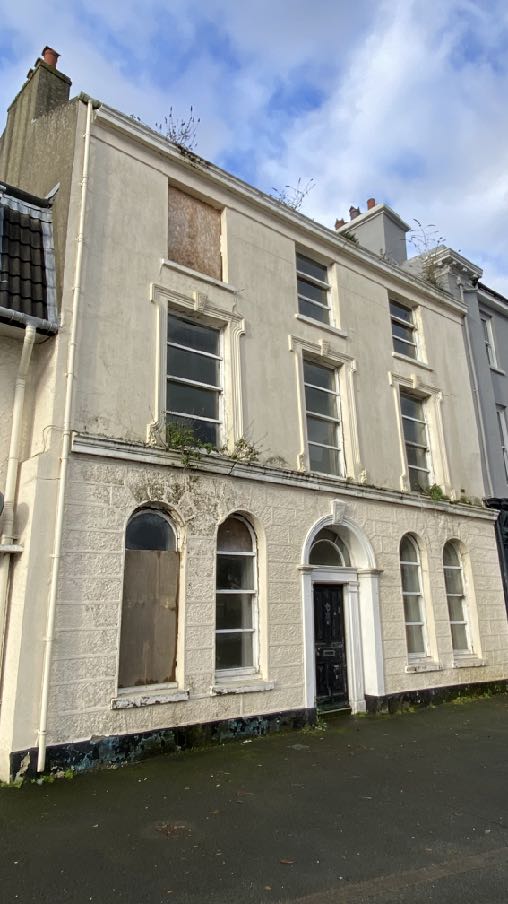
1.3 The two properties appear very different from each other: number 6 is a three storey Victorian building with its front elevation featuring mouldings, string courses and cornice at first floor ground level and eaves level with a traditional chimney at each end and round headed windows on the ground floor. The windows are sliding sash although some are boarded up. The front door is centrally positioned and it too has a round headed with similar fanlight above the door. This building has a basement.
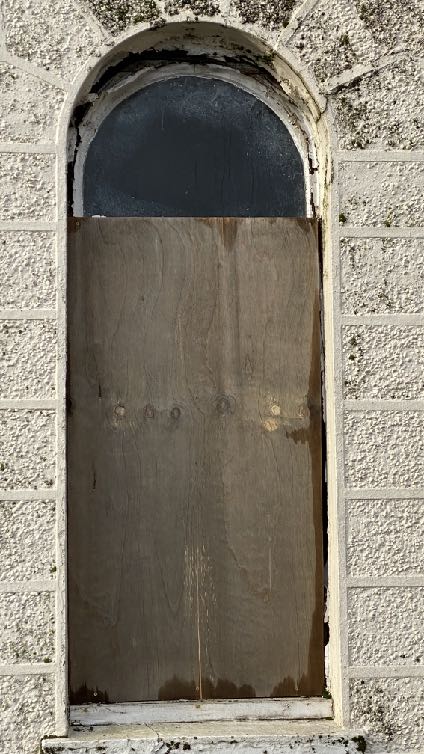
A low-angle photograph of a three-story terraced building facade showing signs of age and disrepair, likely the existing structure proposed for demolition.
1.4 Number 8 by contrast is much more modern with a double Roman heavy mansard roof, brick plinth above which is mock roughcast render work with horizontally proportioned plastic framed casement and fixed windows including three within the mansard level. Whilst this has three floors of accommodation, one is contained within the roof, leading to the building sitting lower than number 6 which in turn is slightly lower than the Railway Hotel.
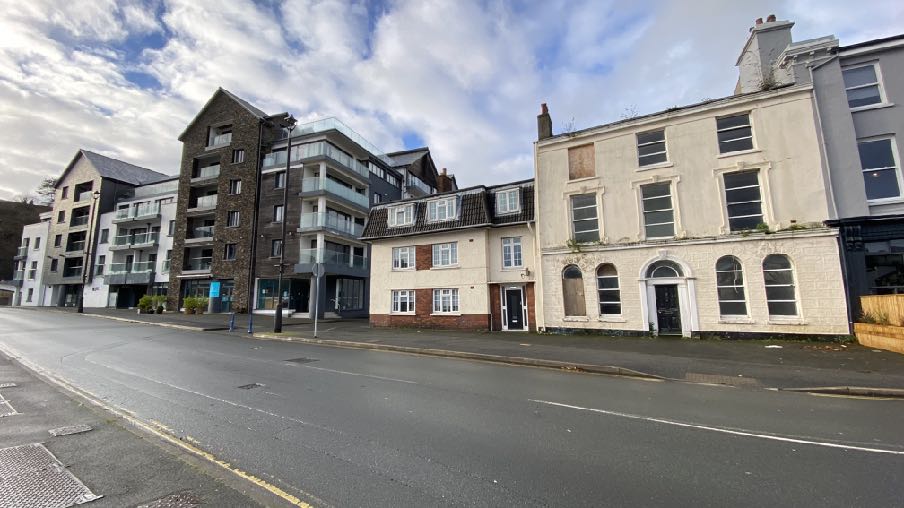
1.5 The terrace is lower in height than the much more modern Quay West apartment block to the south of the lane.
Street-level photograph showing a row of buildings in Douglas, featuring a central white building with boarded-up windows that appears to be the subject of the proposed demolition.A street-level photograph showing a row of buildings in Douglas, featuring modern apartment blocks on the left and older, potentially vacant commercial or residential properties on the right.
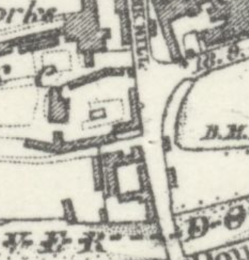
1.6 The layout of this part of Douglas in the 1860s was very different, with no through roadto the south of the railway station and a row of buildings between the Railway Hotel and thestation which no longer exist.
A close-up view of a historical black and white map showing building footprints, property boundaries, and road layouts.
2.0 Planning context Area Plan for the East
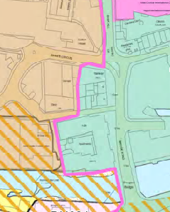
2.1 The site lies within an area designated on the Area Plan for the East which was adopted in 2020, as Mixed Use.
2.2 The pink line delineates the town centre boundary (the site falls within it) and the green shading denotes The Quayside area of Mixed Use for which there is a specific proposal and a number of references in the Written Statement:
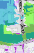
A site location plan showing property boundaries outlined in pink, surrounding roads like Sandy Creek, and adjacent land parcels.
2.4.1 The Strategic Plan states that “the focus of development will continue to be in and around Douglas. The current policy of constraining further greenfield development has aided the process of regeneration within the existing urban area. In terms of the Island Spatial Strategy (ISS) for Douglas and the East, the key elements are:
• continued regeneration within Douglas, particularly around the Promenades and Quayside and Douglas Regeneration Area to create further housing, employment, retail and leisure opportunities…
9.10.10 Mixed Use Area 7 – The Quayside The Quayside area has undergone regeneration on its northern side which has enhanced the area as a destination for people visiting restaurants and bars. On its southern side, industrial uses in older warehouse type buildings predominate. Redevelopment of the southern side to complement the quayside as a whole is to be encouraged. The Quays are also strategic freight corridors and maintaining access for commercial vehicles, including HGV’s, must be considered in any proposed development.
Due to the former industrial uses of South Quay, significant site preparation including decontamination may be required.
Town Centre – Mixed Use Proposal 7 There will be a presumption in favour of food and drink and other leisure-type uses on North Quay. There will be a presumption in favour of the comprehensive re-development of the southern side of the quay, including the potential re-positioning of the highway of South Quay between Old Castletown Road and Fort Anne Road, for new uses in the following categories:
• Tourism
• Offices
• Food and Drink
• Leisure • Reception and function venues
• Business hubs/share-service offices
• Residential uses at first floor level and above.
13.2.4 The Strategic Plan emphasises the importance of the continued regeneration within Douglas, particularly around the Promenades and Quayside
and Douglas Regeneration Area to create further housing, employment, retail and leisure opportunities.
Appendix 2 - recommendations stout in the Retail Study 2009:
The majority of any new floorspace should be distributed primarily to town centre or edge-of-centre locations in Douglas - for example, Strand Street and the existing shopping core and Douglas Quayside.
2.3 The Area Plan also includes Environmental and Infrastructural Constraints Maps. The former shows the Conservation Area in which the site lies and the latter (below left) shows the very rear of the site being within the 2016 Flood Risk Study Area. The Flood Hub maps show this a little more clearly (below right) and denotes the rear of number 6 being at risk of river and tidal flooding.
The Isle of Man Strategic Plan 2016
2.4 This sets out strategic policies which apply Island-wide. It acknowledges Douglas as the principal settlement which will remain the main employment and services centre for the Island (Spatial Policy 1).
A low-resolution, abstract view of a site plan or map featuring prominent red and blue lines overlaid on a grayscale background.A colored site location map showing the application site at the junction of Bridge Road and Bank Hill in Braddan, with surrounding land use zones.
2.5 There are policies which promote sustainable development within settlements and which minimise the reliance on the private motor car (Strategic Policies 1, 2 and 10, Spatial Policy 5 and Transport Policy 1). Business Policies 9 and 10 also promote the provision of retail floorspace in existing settlements.
2.6 There are policies which recommend high standards of design and finish and development which enhances the environment (Strategic Policies 3 and 5, General Policy 2 and Environment Policy 42).
2.7 Development is presumed against which would result in harm to historic fabric and character (Strategic Policy 4).
2.8 Development is encouraged which makes the best use of sites (Strategic Policy 1).
2.9 The Strategic Plan and Planning Policy Statement 1/01 - Conservation of the Historic Environment of the Isle of Man both contain policies which protect the character and appearance of Conservation Areas and where development must either preserve or enhance the character or appearance thereof and take into account the special character of the CA in the determination of any application for development (Environment Policy 35 and CA/2).
2.10 In addition the demolition of buildings which make a positive contribution to the CA is presumed against (Environment Policy 39 and Planning Policy Statement 1/01 - Conservation of the Historic Environment of the Isle of Man CA/6). The PPS also explains that “Similar criteria will be applied as those outlined in RB/6 above, when assessing the application to demolish the building, but in less clear cut cases, for example, where a building could be said to detract from the special character of the area, it will be essential for the Department to be able to consider the merits of any proposed new development when determining whether consent should be given for the demolition of an unregistered building in a conservation area.” The full wording of RB/6 is set out in Appendix One to this document.
2.11 Development which would be at risk or increase risk of flooding is presumed against and development which is considered to be at risk is expected to be accompanied by a Flood Risk Assessment (Environment Policies 10 and 13 and General Policy 2).
2.12 Development is expected to have an acceptable impact on highway safety (Transport Policy 4, General Policy 2). Two car parking spaces are required to be provided per two bed apartments and space for service vehicles of the commercial units. These standards may be relaxed where the development:
(a) would secure the re-use of a Registered Building or a building of architectural or historic interest; or
(b) would result in the preservation of a sensitive streetscape; or
(c) is otherwise of benefit to the character of a Conservation Area.
(d) is within a reasonable distance of an existing or proposed bus route and it can be demonstrated a reduced level of parking will not result in unacceptable on street parking in the locality (Appendix Seven).
2.13 Development is expected to have an acceptable impact on the living conditions of those in adjacent property (General Policy 2 and the Residential Design Guide).
2.14 General Policy 2 sets out general standards of development which should be satisfied: Development which is in accordance with the land-use zoning and proposals in the appropriate Area Plan and with other policies of this Strategic Plan will normally be permitted, provided that the development:
(a) is in accordance with the design brief in the Area Plan where there is such a brief;
(b) respects the site and surroundings in terms of the siting, layout, scale, form, design and landscaping of buildings and the spaces around them;
(c) does not affect adversely the character of the surrounding landscape or townscape;
(d) does not adversely affect the protected wildlife or locally important habitats on the site or adjacent land, including water courses;
(e) does not affect adversely public views of the sea;
(f) incorporates where possible existing topography and landscape features, particularly trees and sod banks;
(g) does not affect adversely the amenity of local residents or the character of the locality;
(h) provides satisfactory amenity standards in itself, including where appropriate safe and convenient access for all highway users, together with adequate parking, servicing and manoeuvring space;
(i) does not have an unacceptable effect on road safety or traffic flows on the local highways;
(j) can be provided with all necessary services;
(k) does not prejudice the use or development of adjoining land in accordance with the appropriate Area Plan;
(l) is not on contaminated land or subject to unreasonable risk of erosion or flooding;
(m) takes account of community and personal safety and security in the design of buildings and the spaces around them; and
(n) is designed having due regard to best practice in reducing energy consumption.
2.15 The Strategic Plan has a number of policies and some guidance on the creation of apartments:
Strategic Policy 12: Favourable consideration will generally be given to proposals for improving the quality and condition of the existing housing stock and for the creation of flats by conversion of redundant boarding houses, and vacant or under-used space above commercial premises subject to compliance with detailed standards (see section 8.13).
Housing Policy 17: The conversion of buildings into flats will generally be permitted in residential areas provided that: (a) adequate space can be provided for clothes-drying, refuse storage, general amenity, and, if practical, car-parking; (b) the flats created will have a pleasant clear outlook, particularly from the principal rooms and (c) if possible, this involves the creation of parking on site or as part of an overall traffic management strategy for the area.
8.13.4 In recent years, interest has grown in the development of residential dwellings from redundant commercial space, primarily above shops. In the United Kingdom, inspiration for such development came from the LOTS initiative (Living Over The Shop) started in 1989 and the FOS programme (Flats Over the Shop), set up in 1991. The Department generally supports the conversion of redundant storage space above shops (which are often outside of residential areas), into residential development unless the occupants would suffer adverse noise, general disturbance or loss of residential amenity from other land uses.
9.4.5 It is accepted that in some circumstances a mix of uses can be appropriatewithin town centre locations such as residential flats above retail units or officeaccommodation, particularly where this can help to ensure the use of the area atdifferent times during the day, thus helping to ensure the security and vitality ofthese areas.
3.0 The proposal
3.1 Proposed is the demolition of all existing buildings on site and their replacement by two new buildings which provide Class 1 (shops) and/or Class 1.3 (consumption of food and drink on the premises) at ground floor level with seven apartments above (Class 3.4). Planning approval as well as Registered Building Consent is required for the demolition of the buildings as number 6 is currently physically attached to the Bridge Public House. Registered Building Consent is also being sought for the demolition of the existing buildings on site.
3.2 The new buildings have been designed to replicate what currently exists at number 6 and a continuation of this style in the new building in place of number 8 albeit slightly lower. The opportunity to expand the available floorspace for the commercial units has been taken by the addition of a single storey of flat roof at the rear, occupying the remainder of the site but leaving the rear private lane free for access.
3.3 No car parking is to be provided on the site.
3.4 Space for the storage of the refuse bins is provided at the rear with access thereto from the rear lane for collection. The building will be set at level of 6.00 which is above the freeboard level above Ordnance Datum recommended by the Flood Team to avoid the property being flooded.
3.5 The existing building at number 6 is in poor condition as is the warehouse building to the rear. There was a further warehouse between this and the lane - to the rear of number 8 which was demolished in 2022 due to its condition.
3.6 Structural surveys were undertaken of all three buildings in 2023 and are attached to this application. The warehouse, which is actually two conjoined buildings, showed signs of pronounced distortion in the roof of the three storey element, there was spalling evident on the north facing wall, a bow at first floor level in the elevation facing the lane and irregularities in the stone and brick face of the two storey wall facing the rear of number 6. Within the building steel beams displayed severe corrosion, timber beams showed decay and softening, support to the first floor joists did not appear robust. On the first and second floors the floor finishes exhibited pronounced sagging and did not feel secure underfoot with pronounced cracking to the walls with spalling finishes.
3.7 The conclusion of the report was that the building is in a very dilapidated condition and is not safe for occupation and in their view, the repairs would be uneconomic to undertake. It recommends demolition of the structure.
3.8 The survey of number 6 was undertaken in July 2023 and revealed that the render face of the front wall to each side of the front entrance exhibited a lean of 100mm over a height of 3.6m above ground level with pronounced vertical cracking at the ground and first floor window reveals with cracking to the first floor string to the front wall.
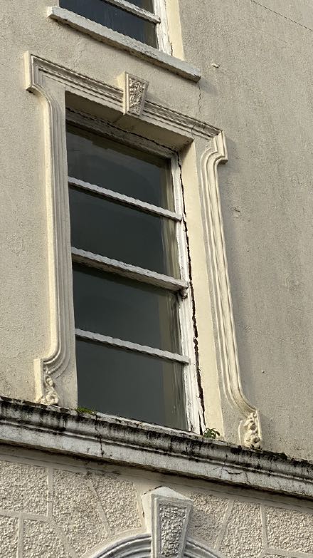
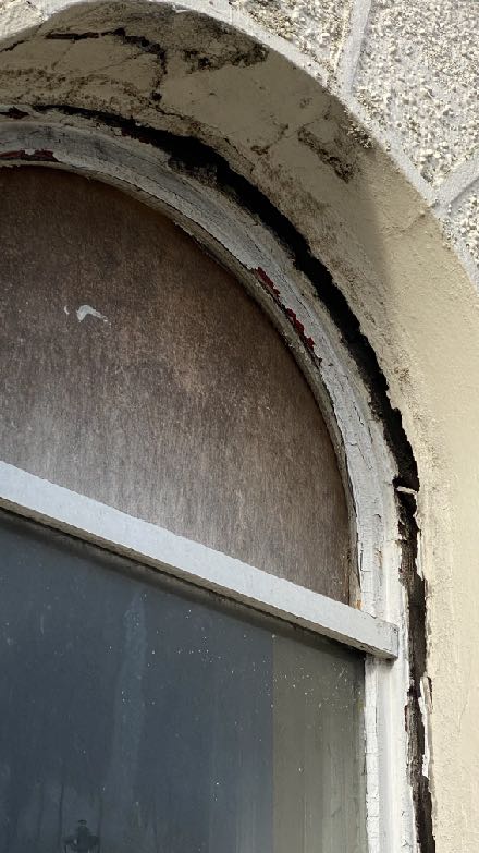
A close-up photograph of an existing building facade, highlighting a tall sash window with decorative molding and rendered walls.A close-up photograph showing a boarded-up arched window with significant cracking and staining on the surrounding stonework.
3.9 The timber lintel to the front wall exhibited decay and partial collapse. The timber lintel to the rear wall had collapsed. Internally the suspended timber floor finishes exhibited sagging and sloping and the front wall lintel was exposed with the wall and ceiling finishes exhibiting some spalling.
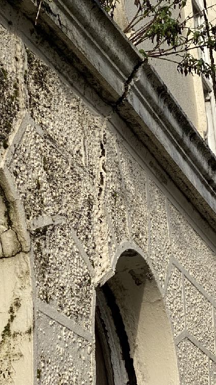
A close-up photograph of a weathered exterior wall featuring pebbledash rendering and stone quoins. An arched opening is visible at the bottom, indicating an older building structure.A close-up photograph showing a boarded-up arched window or doorway set into a roughcast stone wall, likely part of the existing building to be demolished.
3.10 The conclusion was that the building is in a dangerous condition and whilst not in imminent danger of collapse onto public areas, the extent of deterioration and lean to the front wall will propagate further adverse movement, resulting in endangerment to the public. Structural measures to precent further adverse movement of the front wall will be difficult and hazardous to implement. The condition of the front wall and internal structure represents a significant health and safety risk and whilst external shoring could be theoretically introduced to restrain the front wall, such an arrangement impacts the footway and would be unlikely to be visually acceptable. If the front wall were restrained, the decayed timber lintels would need to be replaced, effectively requiring the rebuilding of the entire front wall. Rebuilding the front wall is feasible whilst shorting the remainder of the building but the poor condition of the remainder of the building would not structurally justify retention.
3.11 Their recommendation was to demolish the building with support and waterproofing provided to the adjoining buildings and infilling of the basement taking account of surcharging party walls. Prior to this, the movement of the front wall should be monitored pending demolition and in the event of further significant movement, an exclusion zone should be introduced to safeguard passers by.
3.12 The survey of number 8 was undertaken in July, 2023 and it was observed that there was vertical open joints and stepped and vertical cracking on the front elevation, sloping cills, distorted render and a lean in the rear wall with a pronounced slope inside toward Lake Road. The conclusion here was that the building exhibits significant adverse structural movement which may have arisen during the construction of Quay West apartments around
It recommended the inspection of the internal cavities to confirm the effectiveness of the wall ties and remediate if necessary and monitor movement of the external walls with inspection in 2 years time with further suitable remedial work if then required.
4.0 Planning history
4.1 Planning approval and Registered Building consent was sought for the demolition of the existing buildings on site and their replacement with new development on a number of occasions:
11/00422/CON was for the demolition of the existing buildings was refused for the following reason:
Based on the fact there isn't an approved redevelopment scheme and the resulting visual impact from the proposed demolition on the streetscene and the Conservation area, it is considered the demolition of the buildings would be contrary to Policy CA/6 of Planning Policy Statement 1/01 and Environment Policies 35 and 39 of the Isle of Man Strategic Plan 2007. The Planning Authority considers the loss of the buildings to be unwarranted and would adversely affect the character and appearance of the Conservation Area.
A contemporaneous application, 11/00421/B for the demolition and and their replacement with 12 apartments was also refused for the following reasons:
1. The proposed development would, due to its height, design, massing and external appearance, introduce a prominent and incongruous development within the streetscene, be detrimental to the visual amenities of the locality and which would not preserve or enhance the character and appearance of the Conservation Area. The proposed development would therefore be contrary to General Policy 2 and Environment Policy 35 of the Isle of Man Strategic Plan 2007 and Planning Policy Statement 1/01.
2. Based on the fact that the redevelopment scheme is unacceptable, it is considered the demolition of the buildings would be contrary to Policy CA/6 of Planning Policy Statement 1/01 and Environment Policies 35 and 39 of the Isle of Man Strategic Plan 2007. The Planning Authority considers the loss of the buildings to be unwarranted and would adversely affect the character and appearance of the Conservation Area.
3. The proposed development, due to its height, design and massing would result in demonstrable harm to the residential environment of the apartments of Quay West in terms of overlooking, loss of privacy, visual intrusion and being overbearing and would consequently be contrary to General Policy 2 and Housing Policy 6 of the Isle of Man Strategic Plan 2007.
4. The proposed development would, due to its design and internal layout, result in
i. apartments 3, 6 and 9 having a poor residential environment by virtue of their outlook and lack of access to natural light;
ii. apartments 7, 8 and 10 having a poor residential environment by virtue of dining area/lounge in apartment 10 being positioned above Bedrooms 1 and 2 of apartment 8; and a dining area/lounge in apartment 7 being positioned below the master bedroom of apartment 10, which would result in general disturbance and increased noise to the affected apartments.
iii. apartment 3 having a poor residential environment by virtue of the terrace being overlooked from the above apartment's balconies.
The proposed development would therefore be contrary to General Policy 2 and Housing Policy 6 of the Isle of Man Strategic Plan 2007.
5. The proposed development is contrary to Housing Policy 5 and Paragraph 8.6.1 of the Isle of Man Strategic Plan 2007 in that the development would result in
i. the loss of public sector housing, which would not be replaced as part of the redevelopment scheme, and;
ii. no provision for affordable housing on the net increase of residential units on the site.
6. The proposed development would be contrary to Environment Policy 10 and 13 of the Isle of Man Strategic Plan 2007 in that the development poses an unacceptable risk from flooding and therefore should not be permitted until a detailed flood risk assessment along with details of any proposed mitigation
measures are submitted in accordance with Environment Policy 10 of the Isle of Man Strategic Plan 2007.
7. The proposed development would be contrary to General Policy 2 (h) & (i) and Transport Policy 4 of the Isle of Man Strategic Plan in that adequate visibility cannot be achieved from the proposed access, which would be detrimental to highway safety.
09/0909/F and 09/00911/CON proposed the demolition of the existing outbuildings and was refused for the following reason:
The proposed demolition of the outbuildings would e contrary to Policy CA/6 of Planning Policy Statement 1/01 - Conservation of the Historic Environment of the Isle of Man and Environment Policies 35 and 39 of the Isle of Man Strategic Plan 2007 in that no proper assessment has been carried out to assess the merits/justification for the demolition of the existing building. It is considered that the demolition of the existing outbuildings would adversely affect the character and appearance of the Conservation Area.
4.2 Other applications on the site include the following:
93/00497/B - replacement of windows on front elevation, 6, Bridge Road - permitted
07/02320/B - conversion of ground floor and first floor from residential to restaurant and wine bar, 7, Bridge Road - permitted
07/02321/B - conversion of residential to office use, 6, Bridge Road - permitted
5.0 Assessment
5.1 The proposed development in terms of its use of Class 1.1 and 1.3 with 3.4 above is in accordance with the Mixed Use Proposal 7 in the Area Plan and its designation as Mixed Use within a highly sustainable location in the Island’s capital city and supporting Strategic Policies 1, 2, 10 and 12, Spatial Policy 5, Business Policies 9 and 10 and Housing Policy 4. The opportunity has been taken in the removal of the warehouse at the rear to expand the area which may be used for commercial purposes, to enable this offer to be commercially and operationally attractive to potential occupants.
5.2 The proposed development will reduce the number and size of windows in the southern elevation of number 8 and as such it is considered that the impact on the living conditions of those in the nearest apartments to the south, will be improved on what exists. Whilst there is a new area of flat roof at the rear of the building, this will not be accessible from within the building nor used as part of it and this will be considerably lower than what currently and formerly existed on the site, allowing more space and better outlook for and from the adjacent buildings.
5.3 The issues which are relevant in this case are considered to be as follows:
• The acceptability of the demolition of the existing buildings on site (Environment Policy 39 and CA/6)
• The impact of the proposed replacement buildings on the character and appearance of the area, taking into account that the site lies within a Conservation Area (Environment Policy 35, CA/2, Strategic Policies 3 and 5, Environment Policy 42 and General Policy 2)
• The impact of the development on highway safety including the provision of car parking
• The impact of flood risk on and from the development (Environment Policies 10 and 13)
Demolition of buildings within a Conservation Area
5.4 Unfortunately there is no Conservation Area Character Appraisal for the North Quay CA. However, the site is clearly within it and number 6 is an old building which retains much of its original detailing and interest. There should, therefore, be a presumption in favour of the retention of this building. The warehouse to the rear does not appear to be as old as number 6 but is nevertheless interesting due to its age. The building at number 8 is much
more modern and, we would submit, is an incongruous building within this street scene and which does not contribute positively to the character and appearance of the CA. Its removal would, therefore, not be considered contrary to Environment Policy 39 and CA/6/RB/6.
5.5 The warehouse and number 6 are, however in very poor repair, through no fault of the applicant who purchased the site only recently.
5.6 The Structural Engineer’s reports for the buildings demonstrate the condition of these buildings together with information about what would be involved in any scheme to try to retain the front facade, which would effectively be rebuilt, taking into account the amount of fabric which would need to be replaced to make the building structurally acceptable.
5.7 The detailed plans and accompanying planning application demonstrate that the existing building at number 6 could be replicated, ensuring the continued positive contribution to the Conservation Area and enhanced by the removal of the existing building at number 8 and its replacement with something more sympathetic to number 6 and the otherwise traditional character of the rest of the terrace.
5.8 In summary, we would submit that the demolition and replacement of number 8 should be considered acceptable as this property does not currently contribute positively to the character or appearance of the Conservation Area, and its removal would therefore not contravene Environment Policies 35, 39 or RB/6 and CA/6 of the Planning Policy Statement 1/01. Whilst number 6 has historic interest due to its age as has the warehouse to the rear, their condition, described in the Structural reports attached to this applicant, demonstrate that neither building is in a condition which would enable their retention to be practical or economically viable, with any restoration or even stabilisation or safety works having a detrimental impact on the character and appearance of the area and the safety and convenience of those passing the site. The practicality and viability of retaining structurally deficient buildings are matters which may be considered, as described in RB/6.
Impact of the new development on the character and appearance of the area, including the Conservation Area
5.9 The proposed development will replicate the existing building at number 6 which is considered to preserve the character and appearance of the Conservation Area as it appears from Bridge Road.
5.10 The proposal to replace number 8 with a better designed and detailed building which takes its reference from number 6, is considered an enhancement of the Conservation Area.
5.11 The replacement of the warehouse is considered to have a limited impact due to its position at the rear of the site but a neutral impact due to its current condition thus preserving the character and appearance of the Conservation Area.
5.12 The introduction of a new, single storey extension at the rear in place of the former and current warehouses is considered to preserve the character and appearance of the Conservation Area through the use of appropriate parapet walling and string course detailing with the resulting annex providing much needed commercial and service floor space whilst having an unobtrusive impact on the surrounding buildings and the new buildings themselves.
Highway safety and car parking
5.13 Whilst there is no parking provided, it was resolved that the creation of car parking within the site (where there was none previously with the current parking provision being as a result of the demolition of the former warehouse on the site) would not preserve or enhance the character of the Conservation Area and that, as had been the case previously, the rear of the buildings should be occupied by buildings, not an open hard surfaced area which would not contribute positively to the character or appearance of the Area.
5.14 In addition, the amount of space at the rear of the site is limited and would not permit significant car parking, with limited visibility at the entrance and a narrow lane onto which the parking spaces would emerge.
5.15 The car parking requirement for this site would, according to the Strategic Plan, be two spaces per apartment - fourteen spaces in all with space for servicing of the commercial floorspace. These standards may, however, be relaxed in cases where the provision of parking could prejudice the preservation of a sensitive streetscene, is otherwise of benefit to a Conservation Area and/or the site is within reasonable distance of an existing or proposed bus route and it can be demonstrated that a reduced level of parking will not result in unacceptable on street parking.
5.16 The site is located in the heart of the Island’s capital, within walking distance of one of the largest retail units on the Island and the main shopping area. The existing buildings on
the site have no parking other than within the area cleared where the former warehouse was located. The amount of floorspace is not being increased compared with what exists on the site and the site is also just over 500m walk to the main bus terminal on the Island.
5.17 It is submitted that for all of these reasons, the lack of parking provision on the site should not justify refusal of this application and the proposal satisfies Transport Policies 4 and 7 and General Policy 2.
Flood risk
5.18 The rear of the site is identified as just within an area at risk of river and tidal flooding. As such, the application must demonstrate how the development will not increase flood risk to and from the proposal and include measures to demonstrate how this will be achieved. Discussion with the Isle of Man Flood Team reveals that the minimum floor area which will ensure the property and its occupants will not be at unreasonable risk of flooding, is 5.47mD02 with a freeboard level 300mm above that. The level on the pavement in front of the site is 5.8 and the proposed ground floor level will be set more than 150mm above this so will be above the recommended level. We would submit that this will address Environment Policies 10 and 13.
Living conditions of those in the proposed apartments
5.19 The living conditions of those in the proposed apartments will be the same as for those currently or could live in the existing buildings in terms of the amenity space, outlook and privacy. There are now fewer windows looking towards the apartments on the other side of the lane, improving the amenities of those in both sets of buildings.
5.20 Whilst there is no amenity space within the building, the units are spacious and provide airy and light rooms with pleasant views across the harbour. The Strategic Plan advocates “living above the shop” and the proposed layout follows the lead of many buildings along the quay, including Quay West, which have apartments over commercial premises. We believe that the proposal is acceptable and satisfies Housing Policy 17.
Conclusion
5.21 We would submit that this proposed has been carefully considered to result in the removal of existing fabric of poor structural condition and in the case of number 8, poor visual and architectural form, and their replacement with buildings which contribute positively to and enhance the character and appearance of the Conservation Area, with no
unacceptable impact on the living conditions of those in adjacent property, on highway safety and on flood risk and hope that the application will be considered positively.
Sarah Corlett 27.01.24
Appendix One
EXCERPT FROM Planning Policy Statement 1/01 - Conservation of the Historic Environment of the Isle of Man
POLICY RB/6 DEMOLITION There will be a general presumption against demolition and consent for the demolition of a registered building should not be expected simply because redevelopment is economically more attractive than repair and re-use of an historic building; or because the building was acquired at a price that reflected the potential for redevelopment, rather than the condition and constraints of the existing historic building. Where proposed works would result in the total or substantial demolition of a registered building, an applicant, in addition to the general criteria set out in RB/3 above, should be able to demonstrate that the following considerations have been addressed:-
In judging the effect of any proposed alteration or extension to a Registered Building, it is essential to have assessed the elements that make up the special interest of the building in question. They may comprise not only obvious features such as a decorative facade, or an internal staircase or plaster ceiling, but may include the spaces and layout of the building and the archaeological or technological interest of the surviving structure and surfaces. These elements can be just as important in the simple vernacular and functional buildings, as in grander status buildings. Cumulative changes reflecting the history of use and ownership can themselves present an aspect of the special interest of some buildings, and the merit of some new alterations or additions, especially where they are generated within a secure and committed long-term ownership, are not discounted.
The destruction of historic buildings is in fact very seldom necessary for reasons of good planning: more often it is the result of neglect, or failure to make imaginative efforts to find new uses or incorporate them into new developments.
• The condition of the building, the cost of repairing and maintaining it in relation to its importance and to the value derived from its continued use. Any such assessment should be based on consistent and long term assumptions. Less favourable levels of rents and yields cannot automatically be assumed for
historic buildings and returns may, in fact, be more favourable given the publicly acknowledged status of the building. Furthermore, historic buildings may offer proven performance, physical attractiveness and functional spaces, that in an age of rapid change, may outlast the short-lived and inflexible technical specifications that have sometimes shaped new developments. Any assessment should take into account possible tax allowances and exemptions. In rare cases where it is clear that a building has been deliberately neglected in the hope of obtaining consent for demolition, less weight should be given to the costs of repair;
• The adequacy of efforts made to retain the building in use. An applicant must show that real efforts have been made, without success, to continue the present use, or to find new uses for the building. This may include the offer of the unrestricted freehold of the building on the open market at a realistic price reflecting the building’s condition.
• The merits of alternative proposals for the site. Subjective claims for the architectural merits of a replacement building should not justify the demolition of a registered building. There may be very exceptional cases where the proposed works would bring substantial benefits for the community; these would have to be weighed against preservation. Even here, it will often be feasible to incorporate registered buildings within new development, and this option should be carefully considered. The challenge presented by retaining registered buildings can be a stimulus to imaginative new designs to accommodate them.
Copyright in submitted documents remains with their authors. Request removal
Source & Provenance
Official reference
24/00135/B
Source authority
Isle of Man Government Planning & Building Control