Planning Statement In Respect Of The Installation Of Signage, Manxonia House And Overcliffe, Bay View Road And The Promenade, Port St. Mary Im9 5Da
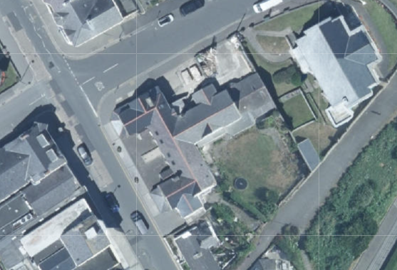
An aerial site location map showing a specific property outlined in red on a street corner, surrounded by other buildings and roads.
1.0 Introduction
1.1 Manxonia House and Overcliffe are conjoined buildings which are approved as being operated as a single unit (see Planning History) which mark the corner of The Promenade and Bay View Road in the heart of Port St. Mary village. Manxonia House sits on the corner and Overcliffe fronts onto The Promenade. To the east of Overcliffe is the Town Hall which provides the local authority’s offices and a community hall above. To the south of Manxonia House is Beach House, an office which is attached to Manxonia House but in separate use and ownership. Manxonia House and Beach House together form a symmetrical, two storey building with projecting gables facing Bay View Road and both having single storey slated, hipped roofed projections forward of the gables.
1.2 Overcliffe is attached to Manxonia House but lower (single storey) with slimmer arch headed windows in the projecting gable which is set back further from the highway than are the gables of the other two properties in the block, and without the single storey addition in front.
1.3 Overcliffe has its frontage open to The Promenade with four parking spaces at right angles to the road available in front of the building.
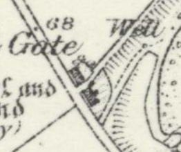
1.4 Overcliffe was thought to be formerly the School House and a group of buildings in this area appear on the 1860s County Series maps (see below). The Conservation Area Appraisal speaks more of this as follows:
“In 1869, the Ordnance Survey map shows a village with only sporadic development between Ballacreggan Farm and the Bay View Hotel. Two pairs of cottages that still stand today, now adjacent to the old school were the first properties on the seaward side of Bay View Road. The next property, some distance away, was a school which was located in the grounds of Ballamona, this later became the first Town Hall. With the exception of a handful
A close-up section of a historical map or site plan showing property boundaries, a gate, and a well.
of cottages, there was no other development until the junction with the Lhargan. At this point there was a group of buildings on the lower part of the Lhargan, including the terrace of cottages which remain today.”
“To the north, the frontage to Chapel Bay (now The Promenade) was sold for division into building plots. A new school was opened at the junction of The Promenade and Bay View Road; this has a date plaque of 1880.”
“Opposite is the former school, now occupied as offices, and the adjacent cottages which were built prior to 1869.”
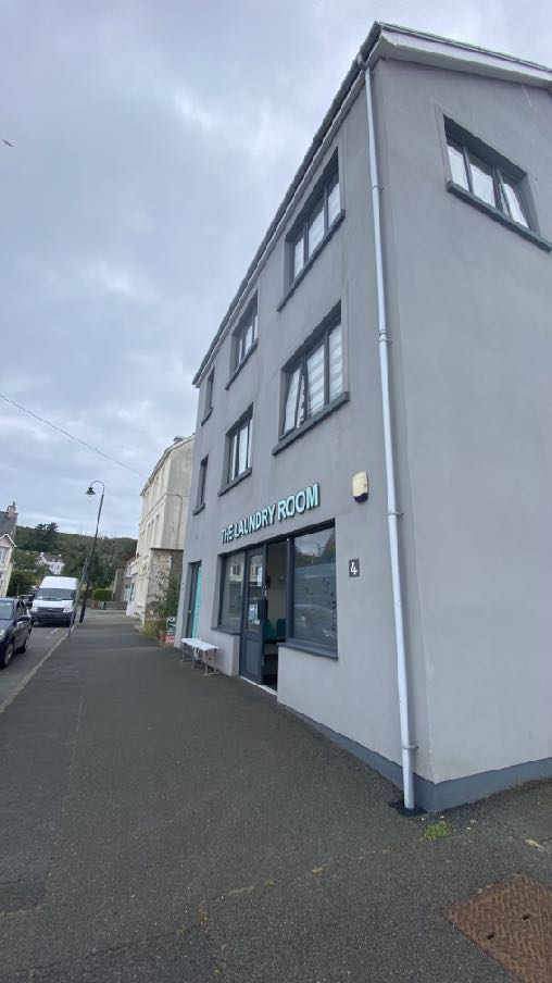
1.4 Across the road from Overcliffe is a public car park where parking is not restricted to any particular period of time but permanent parking is not permitted. Alongside this is a launderette above which is residential accommodation. Alongside this is a vacant development site which had permission for development for a pair of dwellings until 30.04.23 (19/00212/B). Next to this, fronting the corner of The Promenade and Bay View Road is a restaurant and take away, permitted (14/00703/B) to serve food on Tuesdays to Fridays 0800hrs - 1600hrs, on Saturday 0900 - 1600hrs and 0900 - 1400hrs on a Sunday although its current advertisement on the door advises that they are closed Sunday, Monday and Tuesday and the remainder of the week are open 1730 - 2020hrs. The reason given for the control of hours within that approval was “in order to control any potential impact on those living close to the site. The property already has permission for retail sales at the ground floor and as such there should be no further controls over the sale of cold food for consumption off the premises above the current situation which has no hours of operation limitations.”
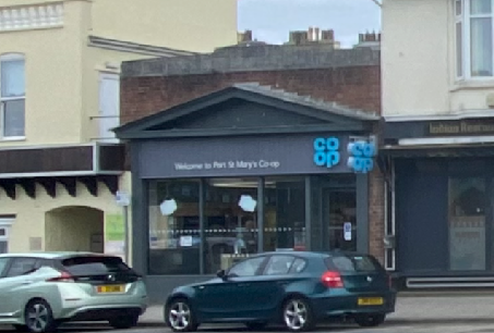
1.5 The Co-op across Bay View Road is currently open from 0800 - 2200hrs and the restaurants on each side currently or previously operated between 1700 - 2300hrs at the earliest and latest. The former Indian Restaurant on the corner has permission for these opening times (06/01160/B).
1.6 To the south of the Beach House office building are Rose and May Cottages - traditional Manx cottages in residential use. To the south of these is a lane which links Bay View Road with The Promenade and to the south of this are Mona Cottage, Cushag Cottage and Chapel Gate - residential properties.
1.7 The site is within an area with mixed usage but including a number of commercial properties most of which have signage. The laundry opposite the site has individual nonilluminated lettering (15/00452/D), the Co-op has illuminated and non-illuminated signage (16/01263/D with no restriction on the hours of illumination) and Ports of Call have a variety of non illuminated signage relating to the businesses operating therein.
A street-level photograph showing the exterior facade of a grey, three-story commercial building with a sign reading 'THE LAUNDRY ROOM'.A street-level photograph showing the exterior of a Co-op store with its signage and cars parked in front.
2.0 Planning policy
2.1 The starting point for the determination of any development proposal is the land use designation. In the Isle of Man this currently takes the form of a variety of plans: the Isle of Man Planning Scheme (Development Plan) Order 1982 was the first development plan which was gradually superseded by a series of local plans in the 1980s and 90s and then in the 2000s onwards, these became Area Plans. The most recent Area Plans cover a large part of the Island and there are adopted plans for the south and east. The remainder of the Island (the north and west) is the subject of an Area Plan which is in the process of preparation and is currently in draft form.
2.2 Area Plan for the South
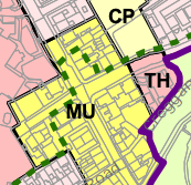
2.2.1 The site lies within an area designated on the Area Plan for the South adopted in 2013, as Mixed Use, reflecting the residential, community, office, retail, food and drink, tourism and recreation uses in the area, and within the proposed Conservation Area (green dashed line - below):
2.2.2 There are no Constraints identified on the relevant map accompanying the Area Plan other than the proposed CA.
A close-up of a planning map showing land use zones labeled MU, CP, and TH with a purple boundary line.
2.2.3 There are no trees, Registered or otherwise, on the site and the building on the site is not Registered. The site not shown as being at risk of flooding on the national flood risk maps.
2.2.4 The land use designation then leads to policies which guide development. These policies are in both the Area/Local Plans and the Strategic Plan, which is generally a nongeographical policy document applicable to the whole Island.
Area Plan for the South Written Statement
2.2.5 This makes no specific reference to the application site. It refers more generally to Port St. Mary as follows:
2.1.8 The key elements of the Island Spatial Strategy for the South are: regeneration within Castletown, Port St Mary and Port Erin to create further housing, employment and leisure opportunities in keeping with the scale of the settlements.
3.4 The overall strategy for the area is to maintain and enhance the character, quality and distinctiveness of the local built vernacular and integrity of the nucleated settlements of Port Erin, Port St. Mary and Ballagawne5 , the scattered traditional farm dwellings and to maintain the field pattern and semi-upland character of the upper slopes.
3.12.1 Port St Mary is a village of 1,913 people (2006 Census) occupying the coastal area east of Meayll Hill between Perwick Bay and Rhenwyllan Mill. It is classified as a ‘Service Village’ in the Island Spatial Strategy. Retail and business uses are generally small-scale, serving essentially local needs, and there is now only limited tourist accommodation. Renewal and redevelopment of the older built fabric has happened only slowly in recent years, but the Village has managed to retain its attractive appearance, charm and character. There is the possibility that harbour improvements will be undertaken in the future following on from the successful schemes in Douglas and Peel. A comprehensive, sensitively designed scheme which addresses satisfactorily the impacts would result in welcome investment in the Village. This may in turn result in greater use and renovation of the older buildings and enhance the Village’s general character and appeal. The Bay Queen Hotel site clearly needs investment, and would
provide a welcome opportunity for new residential development in Port St Mary. In addition, the older part of Port St Mary is proposed to be designated as a Conservation Area (Map 7).
3.14 ii. It is proposed that there should be a new Conservation Area embracing the older part of the Village around the harbour. This is to be assessed under a different process (see Map 7 for draft boundary).
2.2.6 The Written Statement refers to "some office provision” located primarily within the Mixed Use areas where existing buildings should primarily be used to accommodate them, and provides the following advice about retail use and the vitality of the village. There are no policies which refer to advertisements.
2.2.7 The Plan acknowledges that (6.28.5) “Port St Mary Village remains a popular destination for leisure boats, hikers, and railway travellers, and is of considerable visual attraction, particularly around the inner harbour, Lime Street, and Athol Street.”
2.2.8 The Former “National School” on Bay View Road is identified in the Area Plan Written Statement as worthy of consideration for Registration. The draft Conservation Area Appraisal refers to this group of buildings as set out in the Introduction of this document. The Conservation Area has not been adopted but remains a material consideration and development which would prejudice the designation of the CA should be presumed against.
2.3 Strategic Plan 2016
2.3.1 The Strategic Plan sets out generally non-geographic policies which apply Island wide. There is a general encouragement of sustainable development which is directed to established settlements (Strategic Aim, Strategic Policies 1, 2 and 10, Spatial Policy 5 and Housing Policy 4) with Port St. Mary being one of the nine Services Villages which will, where appropriate increase employment opportunities and where housing should be provided to meet local needs and in appropriate cases to broaden the choice of location of housing (Spatial Policy 3).
2.3.2 The design and appearance of development should be appropriate and of a high quality (Strategic Policies 3 and 5 and Environment Policy 42).
2.3.3 Development in areas designated for development is generally supported, provided that it complies with the following general standards of development:
General Policy 2: Development which is in accordance with the land-use zoning and proposals in the appropriate Area Plan and with other policies of this Strategic Plan will normally be permitted, provided that the development:
(a) is in accordance with the design brief in the Area Plan where there is such a brief;
(b) respects the site and surroundings in terms of the siting, layout, scale, form, design and landscaping of buildings and the spaces around them;
(c) does not affect adversely the character of the surrounding landscape or townscape;
(d) does not adversely affect the protected wildlife or locally important habitats on the site or adjacent land, including water courses;
(e) does not affect adversely public views of the sea;
(f) incorporates where possible existing topography and landscape features, particularly trees and sod banks;
(g) does not affect adversely the amenity of local residents or the character of the locality;
(h) provides satisfactory amenity standards in itself, including where appropriate safe and convenient access for all highway users, together with adequate parking, servicing and manoeuvring space;
(i) does not have an unacceptable effect on road safety or traffic flows on the local highways;
(j) can be provided with all necessary services;
(k) does not prejudice the use or development of adjoining land in accordance with the appropriate Area Plan;(l) is not on contaminated land or subject to unreasonable risk of erosion or flooding;
(m) takes account of community and personal safety and security in the design of buildings and the spaces around them; and
(n) is designed having due regard to best practice in reducing energy consumption.
2.3.4 Sustainable development which reduces journeys and energy use and increases thermal efficiency is now encouraged (Residential Design Guide - which also gives advice about design) and Climate Change Act 2021).
2.3.5 Development is expected to optimise/make the best use of sites (Strategic Policy 1).
2.3.6 Development within Conservation Areas must preserve or enhance the character or appearance of the area (Environment Policy 35 and Planning Policy Statement 1/01 Conservation of the Historic Environment of the Isle of Man CA2) and development outside must not adversely affect key views into or out of the CA (Environment Policy 36). There is a presumption against the demolition of buildings within a Conservation Area which make a positive contribution to the character or appearance of the area.
2.3.7 There are Strategic Plan policies which specifically relate to advertisements:
General Policy 6: Within our towns and villages, the display of external advertisements will be permitted on the site or building to which they relate provided they:
(a) are of a high standard of design and materials and relate well to the building and site on which they are to be displayed;
(b) are in keeping with and do not detract from the surrounding area; and
(c) are located so as not to cause a highway safety hazard.
General Policy 7: Within our towns and villages, the display of external advertisements on sites or buildings other than those to which they relate will not generally be permitted.
Environment Policy 37: As a general policy, advertisements within Conservation Areas will be permitted only if:
i) the proposal preserves or enhances the Conservation Area;
ii) the signage is in a style appropriate to the character of the area;
iii) traditional materials and finishes are used and glossy and highly reflective materials are excluded from proposals; and
iv) internally illuminated box fascia and projecting box signs are excluded from the proposals.
2.3.8 There is also guidance within the Planning Policy Statement 1/01 - Conservation of theHistoric Environment of the Isle of Man on the installation of the advertisements withinConservation Areas:
ADVERTISEMENT CONTROL All external advertisements affect not only the appearance of the building upon which they are displayed, but also the neighbourhood where the building is located. This will apply particularly to illuminated signage which is often formed from shiny, nontraditional materials and can result in an unsuitable and harsh appearance which detracts from the character of the building and a conservation area as a whole. The aesthetic quality of a building can be markedly affected by the installation of inappropriate external signage. Where matters such as Corporate Image are a consideration; for a conservation area the Department may require a deviation from what might be acceptable in other high street locations and many large corporate bodies do have alternative designs of signage which might be suitable for use in conservation areas. In many cases it will be necessary for signage to adopt traditional design and materials, in keeping with the character of the building and neighbourhood as a whole. Externally illuminated signage with the appropriate detailing and colour rendered lamps, may be judged suitable.
2.3.9 Development which would create pollution (including that relating to noise) ispresumed against (Environment Policy 22).
3.0 Planning history
3.1 The planning history of an area can give an insight into what has previously been considered acceptable and unacceptable and provided there has been no change of circumstance or policy since then, the same conclusion should be reached in any future development proposals.
3.2 In this case, the site has been the subject of the following applications:
3.2.1 88/01754 proposed the conversion of the premises to offices from retail and was permitted
3.2.2 89/01240/B - alteration to create new bathroom - permitted
3.2.3 13/91375 proposed the conversion of the building to entirely residential and with very similar external changes to what is now proposed. This was refused for the reason that: "Whilst the alterations to the property are not considered to be detrimental to the appearance and character of the property (which lies within a proposed Conservation Area), the loss of commercial use of the ground floor would be contrary to the spirit of the Area Plan for the South, Mixed Use Policy 2 and would reduce the range and viability of the village as a service centre and an attractive place to live and visit."
3.2.4 14/00451/B approved the conversion of the existing office accommodation to two dwellings, retention of existing first floor flat and retention of ground floor retail unit, replacement windows and reinstatement of boundary wall. 4.4
3.2.5 17/01153/B replacement of the existing windows in hardwood frames and was approved
3.2.6 18/00534/B - installation of replacement windows - permitted
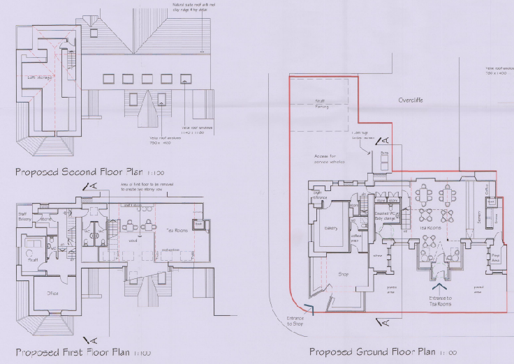
3.2.7 21/00501/B - conversion of Manxonia House from existing office, residential and retail space to retail (Class 1.1) and tea rooms (Class 1.3) - permitted subject, inter alia to a condition which requires:
No customers shall be served or remain in the building outside the following
hours: 8am - 9pm. Reason: In the interests of public amenity.
It should be noted that the application did not propose any particular opening hours but the planning officer recommends at his paragraph 6.4.3 without any other reference, that the opening hours should be so restricted to ensure that the premies is not open to customers outside the hours of 8am and 9pm to reduce the risk of noise disturbance during unsociable hours. He preceded this with the following comments:
However, the site is within a designated Mixed Use area which seeks to ensure that uses of the type proposed are centralised within town and village centres and to ensure that these centres remain vibrant and viable. Separate licensing and other legislation relating to opening hours and noise nuisance may come into consideration should future issues arise. For the current proposal, noise nuisance on the occupiers of the adjacent properties is not considered likely to be so severe as to warrant a refusal of planning permission.
The proposed layout was as follows:
The image displays architectural floor plans for the ground, first, and second floors of a commercial building. The layouts detail spaces including a shop, tea rooms, office, and staff parking areas.
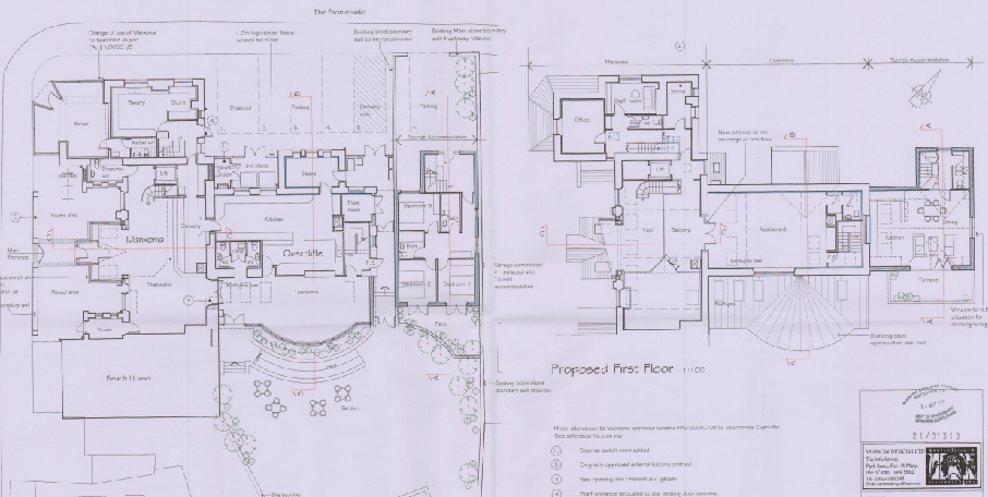
3.2.8 21/01313/B is described as proposing the conversion of Overcliffe from existing residential and commercial space into retail (class 1.1), tea rooms (class 1.3), restaurant (class 1.3), and tourist accommodation but included the merging of Overcliffe with Manxonia House and use of the unit as a single cafe/restaurant/tea rooms with extension, effectively superseding the previous application solely for Manxonia House (21/00501/B). This application was permitted subject, inter alia to a condition which required:
No customers shall be served or remain in the building outside the following
hours: 9am - 11pm.
Reason: The application has been assessed on this basis as requested in the application and in the interests of public amenity.
The proposed layout was as shown below including tables and chairs in the rear garden area:
This image displays a technical architectural floor plan labeled 'Proposed First Floor' showing detailed room layouts including a kitchen, dining area, and bedrooms.
3.2.9 23/00288/B - removal of two chimneys (retrospective) - permitted
3.2.10 Most recently planning approval has been granted for the variation of the conditions relating to the opening times of the property (23/01196/B).
4.0 The proposal
A night-time photograph of an illuminated rectangular sign reading 'hallmark HOTELS' mounted on a dark brick wall.A night-time photograph showing an illuminated sign for 'S & S NORTHERN' with contact details mounted above a building window.A 3D technical rendering of a rectangular illuminated sign with a red face and visible LED lighting elements on the back.
4.1 Proposed here is the installation of signage on the building. There are to be two signs, one rectangular sign and the other a smaller, circular sign. The rectangular sign is to be positioned above the lean to annex on the corner of Bay View Road and the Promenade and the other above the new entrance porch on the Bay View Road elevation.
4.2 The signage is both to be in a fret cut panel with acrylic lettering and with internal illuminators within the rectangular sign. Examples of similar signs are provided:
Examples of Fret Cut Tray Signage
Illumination
Fret Cut Panel with acrylic opal light diffuser sheet
Stencil cut detail backed in 3mm opal 050 acrylic, Flat cut 3mm white matt aluminium composite 12v LED carrier panel BEHIND STENCIL CUT DETAIL ONLY
5.0 Assessment
5.1 The site is a prominent one in the heart of Port St. Mary and on the approach to the centre. In addition, the building is an interesting and historic one and within a proposed Conservation Area. As such, any advertisements to be attached to the building need to respect the importance of the building and its site and the choice of materials need to be carefully made.
5.2 The signage is not box fascia and involves relatively simple materials and design, with few colours and no internal illumination. There are also only to be two signs so as not to clutter the building.
5.3 It is considered that the choice of materials and design is appropriate for the building, whether or not the Conservation Area status is confirmed and that what is proposed complies with General Policies 6 and 7 and Environment Policy 37. Whilst the Conservation Area is not yet adopted, it is important that decisions taken do not prejudice any potential future adoption and it is submitted that what is proposed would not do so.
Sarah Corlett 02.01.2024
Copyright in submitted documents remains with their authors. Request removal
Source & Provenance
Official reference
24/00002/D
Source authority
Isle of Man Government Planning & Building Control