Planning Statement For The Erection Of Stables, Burma Road, Andreas
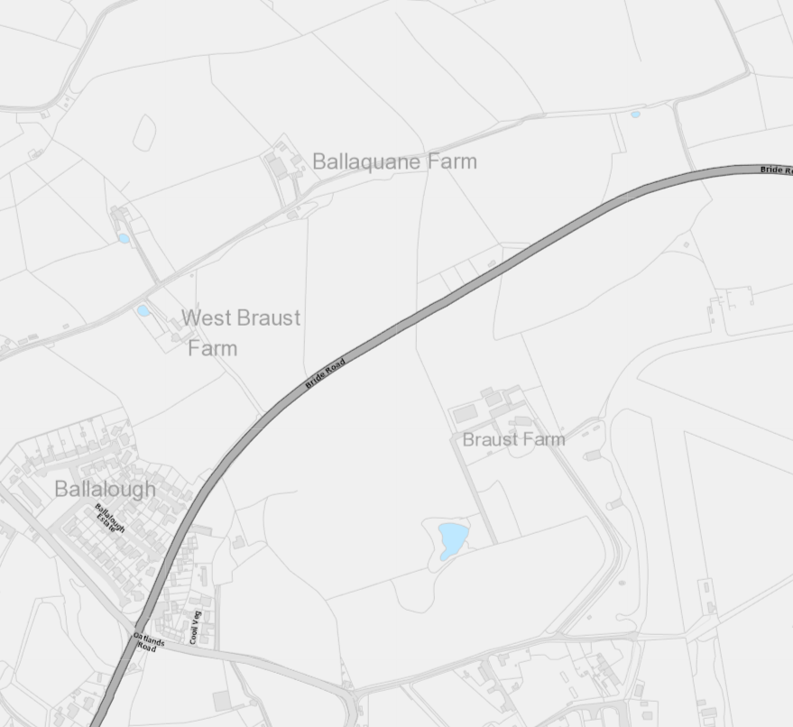
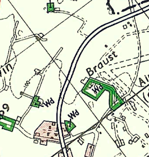
A site location map showing the proposed development area near Braust Farm and Ballaquane Farm along Bride Road.
The site
1.0 Introduction
1.1 The site is a triangular shaped field which sits between fields 124535 and 124359 which are all to the north west of the A17 Burma Road (also known as the Bride Road) which leads north east from Andreas village towards Bride. The site sits just over 600m from the Oatlands Road/Smeale Road/ Burma Road and Bride Road roundabout.
1.2 The site extends to 1.67ha (4 acres) and includes a small length of land within field 124359 which leads to and includes the entrance into both fields from the A17.
1.3 The entrance onto the A17 is a simple break in the roadside hedge with an upward slope from the road into the field where a series of fences demarcates each separate ownership. The fields to the north of the site are owned by the applicant’s family.
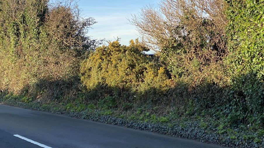
1.4 The roadside hedge is a traditional Manx sod hedge with gorse. Hawthorn and ivy growing upon it.
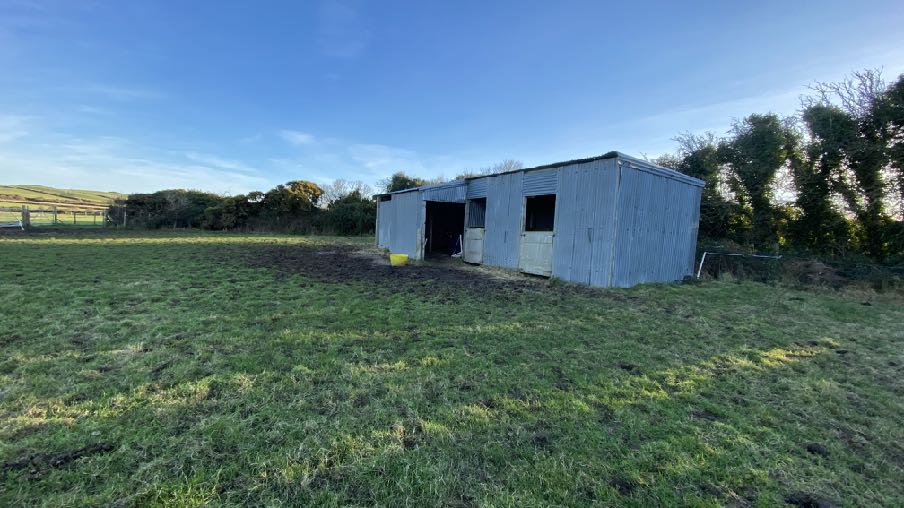
1.5 The site contains a single building which is a corrugated stable block which has been on the site for some time. This is just visible from the A17 although in summer months, the hedge foliage would screen it from view.
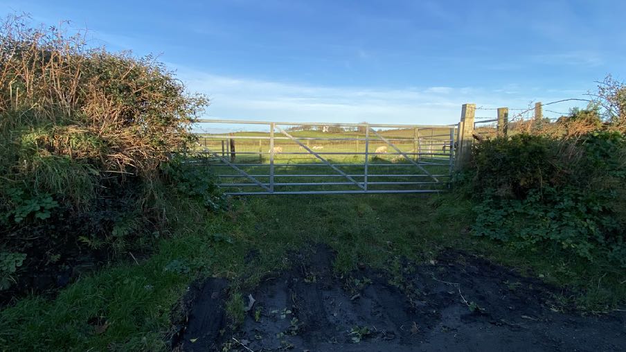
A photograph showing a metal farm gate at the end of a muddy track, leading to a grassy field with sheep and bordered by hedgerows.
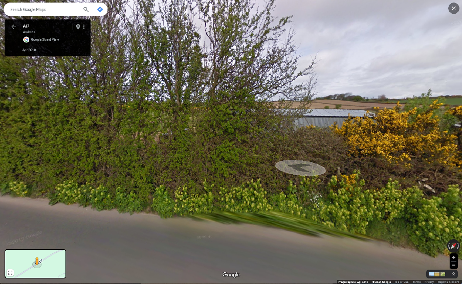
1.6 The existing stable building was on the site when the applicants recently purchased the site and whilst no planning approval appears to have been sought for the structure, it has been there since at least 2010, as is clear from the Google Streetview image below which renders the structure immune from the issue of an enforcement notice (Town and Country Planning Act 1999 Part 1(3)(a).
A photograph showing a paved road verge bordered by dense vegetation, bushes, and trees in a rural setting.A Google Street View screenshot showing the roadside boundary along the A17 with a dense hedge and gorse, and an agricultural building visible in the background.
The existing stable
A photograph showing a corrugated metal stable building situated in a grassy field with trees and rolling hills in the background.
2.0 Planning policy
2.1 The starting point for the determination of any planning application is the land use designation in the relevant adopted development plan. In this case this is the Isle of Man Planning Scheme (Development Plan) Order 1982 although this is in the process of being updated by the Area Plan for the North and West. On the 1982 Plan (below) the site is within an area not designated for a particular purpose and not part of an area of an area of High Landscape or Coastal Value and Scenic Significance.
2.2 In this part of the Island, the Isle of Man Planning Scheme (Development Plan) Order 1982 is being replaced by a new Area Plan (for the North and West). This is currently in draft form only so has limited effect but confirms the designation of the site not for any particular purpose. This also has maps which show specific constraints, including the Environmental Constraints and Infrastructure constraints of which there is none in relation to this site.
2.3 The site not shown on the national flood risk maps as being at risk of flooding.
2.4 Trees are generally protected under the Isle of Man Strategic Plan Environment Policy 3 although there are no Registered Trees on the holding and only self seeded hawthorn trees on the boundary with the road.
A topographic site plan showing a green highlighted boundary near a location labeled 'Braust', with surrounding buildings and contour lines visible.
2.5 Ecology is protected under Environment Policies 4 and 7.
2.6 There is a general presumption against development in undesignated areas, as set out in General Policy 3 of the Strategic Plan (see Appendix One). Environment Policy 1 presumes against development which would be harmful to the character and appearance of the countryside.
2.7 This site lies within an area on the Landscape Character Assessment as part of a large area of Undulating Lowland Plain (F3). The full advice on this type of area is set out in Appendix Two with the most relevant parts highlighted. The draft Area Plan summarises this as follows with a relevant Landscape Proposal:
6.4.3 The Undulating Lowland Plain of Andreas and Jurby (F3) encompasses a swathe of farmland underlain by the predominantly flat topography of the northern plain. To the west, the narrow course of the Lhen trench meanders through the landscape. The main A19 and A17 roads cross the area interlinking with a network of minor roads often lined with tall Manx sod banks. Settlement pattern is scattered and relatively isolated with the Andreas and Jurby Industrial Estates and IOM prison providing the largest groups of buildings within the area. Overall, there is a strong sense of tranquillity and openness. A strong recognisable sense of place is provided by views to the dramatic backdrop of the Uplands to the south, views of St. Patrick’s Church and distant views to the sea at the eastern and western edges of the area.
Landscape Strategy To conserve and enhance: a) the character, quality and distinctiveness of this rural area including the scattered settlement pattern, relatively strong field pattern delineated by a mixture of stone walls and relatively tall Manx hedge-banks and its network of enclosed minor rural roads
Key Views - Glimpsed views to the sea from the eastern and western edges of the area. Panoramic open views southwards towards a dramatic upland backdrop. Open views to landmark church towers (particularly St. Patrick’s Church) to the west of Jurby.
2.8 Whilst there is a presumption against development in this area according to General Policy 3 pf the Strategic Plan, there is provision for the erection of buildings for agriculture or equestrian pursuits (General Policy 3f and Environment Policies 15, 19, 20 and 21).
2.9 Sites of archaeological interest are protected (Environment Policy 40) and in archaeologically sensitive sites additional information is sometimes required (EP 41). Manx National Heritage have commented on 22/00232/B but only in respect of ecology, not archaeology. Clarification of the archaeological site would be useful.
2.10 The highest quality agricultural land (Classes 1 -2 including 2/3 and 3/2) will be protected fromdevelopment (Environment Policy 14). The soil here is Class 2.
3.0 Planning history
3.1 The site has not been the subject of any previous applications.
3.2 In addition, these applications for the erection of stables may be considered relevant:
21/01170/B - Ballahutchin Beg, Dalby, Patrick - permitted
3.3 This application proposed stables in an area of an area of High Landscape or Coastal Value and Scenic Significance but where the planning officer considers that “the key issues in the assessment of the application are the visual impacts of development on the character and appearance of the countryside and AHLV, whether there are any amenity impacts on the neighbours and the proposals effect on highway safety.” She also notes: “In this particular case, the proposal is for a single stable building and its siting in close proximity to the existing buildings along the main road, its low level design, green roof finish and timber cladding and its existing and proposed landscaping works all amount to a circumstance in this specific case which is considered to be exceptionable so as to not result in any adverse visual impacts on the AHLV” and “The submission indicates that the field is already used for grazing by the applicant's family horses and the proposed stable shelter is to be conducive to that. The nearest two properties are owned by the applicant and their family and thus it is not expected that the proposal will result in any unacceptable amenity harm given this situation. Beyond these two properties are a church and other residential properties however the distances between these and the proposed stable will limit any amenity impacts to an acceptable level so as to not harm any general living conditions or day-to-day operations.” And finally, “7.2 The proposal in this case would not result in the loss of high quality agricultural land (zoned as Class 3/2) and could be argued not to be a large scale equestrian development as referred to in
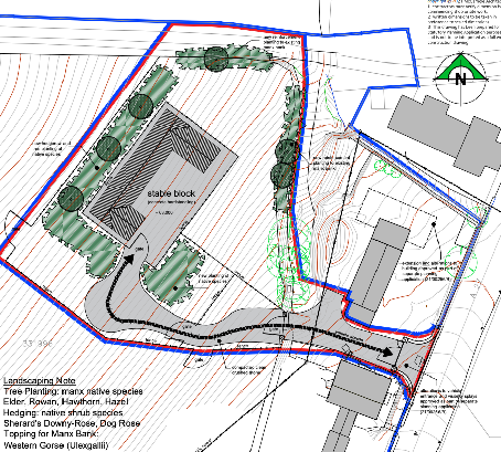
This image displays a site plan showing a plot of land outlined in red and blue boundary lines adjacent to Dalby Road. It illustrates the layout of existing buildings, including a barn and stables, and surrounding properties.This image displays a detailed site plan for a proposed stable block, illustrating the building footprint, access driveway, and surrounding landscaping features such as tree planting and hedging.
EP20. Nevertheless the overall the size, scale and positioning of the stable in proximity to and behind existing building is considered exceptional enough so out to outweigh EP 20 and the proposal is not considered to have an acceptable visual impact so as to not adversely harm the character and appearance of the AHLV or wider countryside.”
3.4 A stable a store room was approved to the north of the site in field 121172 under 06/01345/B.
3.5 Not all applications for stabling are considered so positively, however. 22/01158/B followed an earlier application which was also refused, for stabling, access and hardstanding at Garth, Marown.
3.6 The applications were refused due to the perceived lack of justification, the visual impact in an open position within the countryside and the isolated location of the proposed structures.
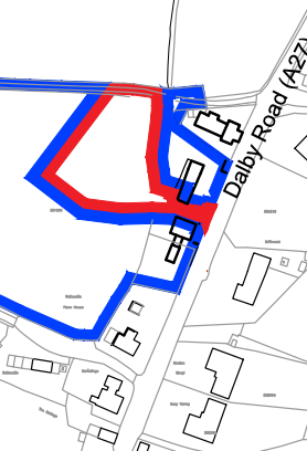
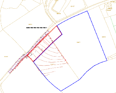
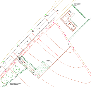
A site location plan showing a large plot of land outlined in blue with a specific area marked in red, set against a background of field boundaries and roads.A technical site plan showing property boundaries, road access, and the layout for a proposed stable building.
4.0 The proposal and assessment
4.1 The site lies within an area which is not designated for development but the Strategic Plan makes it clear that development associated with equestrian facilities can be acceptable if there is no adverse impact on the environment, citing local amenity and highway safety as well as the impact on the character and appearance of the countryside in terms of siting, design, size or finish. The buildings must also be appropriate to their function.
4.2 The site extends to 1.6ha (4 acres) acres and currently accommodates horses with an anticipated 4 when the applicants’ other horses which are kept elsewhere will be moved here following the sale of that other site.
4.3 The proposed stables are modest in size and appearance and their construction is typical of this type of building with a shallow pitched roof system, no first floor and a timber construction (no cavity walls or blockwork). The building is L shaped with 12m parallel with the road and 10m projecting north westwards. The building will have an Onduline black sheeted roof (made from partly recycled materials) and timber walls. The eaves level is 2.2m and the ridge 3.1m high.
4.4 The existing stable building will be dismantled and removed from site once the new stable is ready for use.
4.5 The existing roadside hedge prevents any significant view of the proposed stable from the public highway, and also provides shelter for the building from the south easterly winds with the orientation of the new stables also designed to provide shelter from the prevailing south westerly winds which can be severe in this part of the Island and whilst also providing shade and additional protection from insects from summer sun. The stables will also allow stabling which will rest the grazing areas, particularly in winter months.
4.6 The proposed stables will have no impact on ecology or trees.
4.7 The site lies in an area where the soil is Class 2. However, the proposed stable is not significantly different in size or siting to the existing and the field and its neighbours are already used for grazing so there is no impact on productive agricultural land and the area taken up by the stables is small compared with the overall acreage. There would be no material change on agriculturally productive land as a result of this application.
4.8 We believe that the proposal complies with the relevant policies and has no adverse environmental impact. The building would not result in any loss of local amenity and there will be no increase in traffic as a result of the proposal, arguably there could be a reduction in that better facilities and storage on site may reduce the number of visits to the site. Whilst visibility at the entrance for those existing the fields, is poor, the proposal will not significantly change the amount of traffic using it and as stated above, might actually reduce traffic.
4.9 Whilst the Landscape Character Assessment refers to traditional buildings in render and slate, the policies on equestrian development require that buildings are built appropriate to their function and a blockwork and slate building would not only be more visible and eye catching but would also be more permanent and potentially contrary to Environment Policy 21.
4.10 The use of the land for grazing is technically compliant with the definition of agriculture in the Strategic Plan but approval is also sought, if needed for the use of the land for the keeping of horses which is not considered to have an adverse impact any more than if the land were used for grazing by an agricultural animal.
4.11 We believe that there will be a significant improvement in both animal welfare as a result of more structurally sound and thermally efficient stabling for the animals, and visual impact in that a building in poor repair will be replaced by one of better construction and appearance and in darker finish materials.
Sarah Corlett 03.01.2024
Appendix One - policies
Strategic Plan
General Policy 3: Development will not be permitted outside of those areas which are zoned for development on the appropriate Area Plan with the exception of:
(a) essential housing for agricultural workers who have to live close to their place of work; (Housing Policies 7, 8, 9 and 10);
(b) conversion of redundant rural buildings which are of architectural, historic, or social value and interest; (Housing Policy 11);
(c) previously developed land(1) which contains a significant amount of building; where the continued use is redundant; where redevelopment would reduce the impact of the current situation on the landscape or the wider environment; and where the development proposed would result in improvements to the landscape or wider environment;
(d) the replacement of existing rural dwellings; (Housing Policies 12, 13 and 14);
(e) location-dependent development in connection with the working of minerals or the provision of necessary services;
(f) building and engineering operations which are essential for the conduct of agriculture or forestry;
(g) development recognised to be of overriding national need in land use planning terms and for which there is no reasonable and acceptable alternative; and
(h) buildings or works required for interpretation of the countryside, its wildlife or heritage.
Environment Policy 1: The countryside and its ecology will be protected for its own sake. For the purposes of this policy, the countryside comprises all land which is outside the settlements defined in Appendix 3 at A.3.6 or which is not designated for future development on an Area Plan. Development which would adversely affect the countryside will not be permitted unless there is an over-riding national need in land use planning terms which outweighs the requirement to protect these areas and for which there is no reasonable and acceptable alternative.
Environment Policy 3: Development will not be permitted where it would result in the unacceptable loss of or damage to woodland areas, especially ancient, natural and semi-natural woodlands, which have public amenity or conservation value.
Environment Policy 4: Development will not be permitted which would adversely affect:
(a) species and habitats of international importance:
(i) protected species of international importance or their habitats; or (ii) proposed or designated Ramsar and Emerald Sites or other internationally important sites.
(b) species and habitats of national importance:
(i) protected species of national importance or their habitats;
(ii) proposed or designated National Nature Reserves, or Areas of Special Scientific Interest; or
(iii) Marine Nature Reserves; or
(iv) National Trust Land.
(c) species and habitats of local importance such as Wildlife Sites, local nature reserves, priority habitats or species identified in any Manx Biodiversity Action Plan which do not already benefit from statutory protection, Areas of Special Protection and Bird Sanctuaries and landscape features of importance to wild flora and fauna by reason of their continuous nature or function as a corridor between habitats.
Some areas to which this policy applies are identified as Areas of Ecological Importance or Interest on extant Local or Area Plans, but others, whose importance was not evident at the time of the adoption of the relevant Local or Area Plan, are not, particularly where that plan has been in place for many years. In these circumstances, the Department will seek site specific advice from the Department of Agriculture, Fisheries and Forestry if development proposals are brought forward.
Environment Policy 14: Development which would result in the permanent loss of important and versatile agricultural land (Classes 1-2) will not be permitted except where there is an overriding need for the development, and land of a lower quality is not available and other policies in this plan are complied with. This policy will be applied to
(a) land annotated as Classes 1/2 on the Agricultural Land Use Capability Map; and
(b) Class 2 soils falling within areas annotated as Class 2/3 and Class 3/2 on the Agricultural Land Use Capability Map.
Environment Policy 15: Where the Department is satisfied that there is agricultural or horticultural need for a new building (including a dwelling), sufficient to outweigh the general policy against development in the countryside, and that the impact of this development including buildings, accesses, servicing etc. is acceptable, such development must be sited as close as is practically possible to existing building groups and be appropriate in terms of scale, materials, colour, siting and form to ensure that all new developments are sympathetic to the landscape and built environment of which they will form a part. Only in exceptional circumstances will buildings be permitted in exposed or isolated areas or close to public highways and in all such cases will be subject to appropriate landscaping. The nature and materials of construction must also be appropriate to the purposes for which it is intended. Where new agricultural buildings are proposed next to or close to existing residential properties, care must be taken to ensure that there is no unacceptable adverse impact through any activity, although it must be borne in mind that many farming activities require buildings which are best sited, in landscape terms, close to existing building groups in the rural landscape.
Environment Policy 19: Development of equestrian activities and buildings will only be accepted in the countryside where there will be as a result of such development no loss in local amenity, no loss
of high quality agricultural land (Classes 1 and 2) and where the local highway network can satisfactorily accommodate any increase in traffic (see Environment Policy 14 for interpretation of Class 1 and 2).
Environment Policy 20: There will be a presumption against large scale equestrian developments, which includes new buildings and external arenas, in areas with High Landscape or Coastal Value and Scenic Significance unless there are exceptional circumstances to override such a policy.
Environment Policy 21: Buildings for the stabling, shelter or care of horses or other animals will not be permitted in the countryside if they would be detrimental to the character and appearance of the countryside in terms of siting, design, size or finish. Any new buildings must be designed in form and materials to reflect their specific purpose; in particular, cavity-wall construction should not be used.
Appendix Two
Landscape Character Assessment
F3 ANDREAS AND JURBY Key Characteristics
• Swathe of farmland (covering the breadth of the Island).
• Irregular pattern of medium-sized arable and pasture fields.
• Field boundaries demarcated by traditional Manx hedges and simple post and wire fences.
• Inter-linking network of minor rural roads serve the area, together with the A10, A17 and A19.
• Generally few vertical elements, other than occasional telegraph poles.
• Scattered and relatively isolated settlement pattern.
• Traditional farm buildings (characteristically white, with grey roofs).
• Key settlements include the small town of Andreas and the villages of Bride, Jurby and Sandygate.
• The Isle of Man Government Industrial Estate and adjacent Jurby Aerodrome
• Disused airfield at Andreas
• Churches provide prominent landmarks within views.
• Views to dramatic upland backdrop to the south provide strong sense of place.
• Strong sense of openness and tranquillity (at distance from main A19 and A17 roads).
• Slightly marked sinuous valley of Lhen Trench.
• Sandpit at Cronk-y-Scotty
Overall Character Description Situated to the north of the Island, this landscape character area encompasses a swathe of farmland underlain by the predominantly flat topography of the northern plain. To the west, the relatively narrow course of the Lhen trench meanders through the landscape, which exhibits an irregular pattern of medium-sized arable fields and rough grassland/pasture. A variety of different forms of hedgerows and simple post and wire fences demarcate field boundaries. To the west, mature, intact low, trimmed hedges dominate the hedgerow network. Several single mature deciduous trees within Manx hedgerows and fields also contribute to a mature recognisable landscape structure. The main A19 and A17 roads (a source of noise and visual intrusion) cross the area and an inter-linking network of minor roads, often lined with species-rich verges, help to provide access to farms and settlements. Generally, few vertical elements punctuate the skyline of the area. However, telegraph poles and the telecommunications mast at Jurby Industrial Estate are a visible human influence. Settlement pattern is scattered and relatively isolated, with the Andreas and Jurby Industrial Estates providing the largest groups of buildings within the area. Several isolated farmsteads and individual houses also pepper the landscape. Traditional farm buildings characteristically exhibit white walls (which often provide a bright contrast to the muted upland backdrop to the north) and grey roofs. Alongside these traditional buildings, modern agricultural sheds and warehouses are sometimes visually intrusive. In addition, the distinctive churches of St. Andrews Church at Andreas (built predominantly from Sulby Glen stone) and St. Patrick’s Church to the west of Jurby and their associated medieval crosses are landmark features landscapes within the area. St. Patrick’s Church is
particularly prominent within views across the surrounding open, flat landscape. The prefabricated buildings on an old air force base and disused runway at Jurby (now housing several small businesses and shops, including Jurby Junk) exhibit a strong human influence over the character of this part of the area. Construction of the new prison development is also associated with this part of the area. Overall, there is a strong sense of tranquillity and openness throughout the area. A strong recognisable sense of place is provided by views to the dramatic backdrop of the Uplands to the south, views of St. Patrick’s Church and distant views to the sea at the eastern and western edges of the area.
Key Views
• Glimpsed views to the sea from the eastern and western edges of the area.
• Panoramic open views southwards towards a dramatic upland backdrop.
• Open views to landmark church towers (particularly St. Patrick’s Church) to the west of Jurby.
Historic Features
• St. Patrick’s Church and medieval crosses.
• St. Andrew’s Church and medieval crosses.
• Old airfields at Jurby and to the east of Andreas.
Ecological Features
• Species-rich verges.
• Mature hedgerows and single mature deciduous trees.
• Patches of rough grassland
• Area of Special Scientific Interest at Ballacrye
Evaluation of Inherent Landscape Sensitivities
• Strong sense of tranquillity.
• Scattered isolated settlement pattern.
• Enclosed minor rural roads.
• Vernacular character of buildings and churches.
• Presence of Manx Mile stones.
• Few tall vertical elements.
• Dramatic views south to Uplands.
• Field pattern delineated by a mixture of stone walls, relatively tall Manx hedge-banks and post and wire fences.
Landscape Strategy The overall strategy should be to conserve and enhance the character, quality and distinctiveness of this rural area including the scattered settlement pattern, relatively strong field pattern delineated by a mixture of stone walls and relatively tall Manx hedge-banks and its network of enclosed minor rural roads.
Copyright in submitted documents remains with their authors. Request removal
Source & Provenance
Official reference
24/00015/B
Source authority
Isle of Man Government Planning & Building Control