Loading document...
Public Estates \& Housing Division
Development of 20 Affordable Homes, Ballacubbon, Colby
April 2017
1.0 Introduction 2.0 Site 3.0 Design Proposals 4.0 Consultations 5.0 Transport Assessments 6.0 Compliance with 2016 Isle of Man Strategic Plan General Requirements 7.0 Disability Discrimination Act (DDA) 8.0 Drawings and Information Details 9.0 Aerial Images of Existing Site and Visualisations of Development Proposals
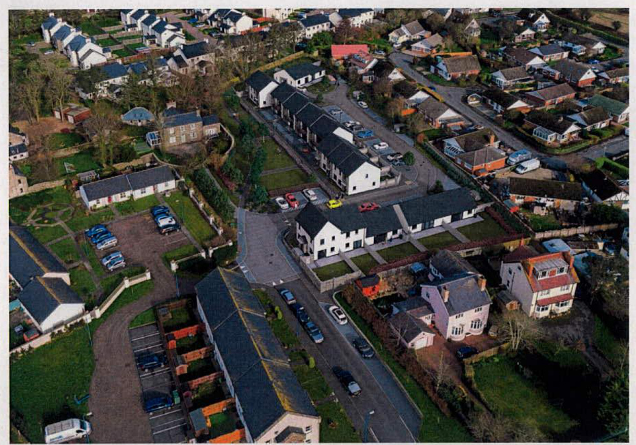
1.1 The Department of Infrastructure - Public Estates \& Housing Division proposes to construct 20 new Affordable Homes on "Phase 2" land at Ballacubbon, Colby adjacent to its earlier development. 1.2 The site identified as "Site 13" on Map 6 of the "Area Plan for the South" which came into operation on 1 March 2013 is part of a parcel of development land purchased by the former Department of Local Government and the Environment, of which approximately half has already been developed with Affordable Homes (First Time Buyer and Public Sector). 1.3 The site wraps around the boundaries of the original farmhouse and out buildings which remain in private ownership with a legal "Right of Way" (vehicular and pedestrian) extending from the farm house to the A7. {{image:191604}}
Recent aerial image showing proposed Ballacubbon development site 1.4 The Department of Infrastructure - Public Estates and Housing Division has prepared the design proposals and this design statement to support this Planning Application. The following consultants have also contributed to the Application:
Engineer: John Gray Chartered Structural and Civil Engineers, 5 Drinkwater Street, Douglas, Isle of Man, IM1 1AT Contact: J Gray Landscape Architect: Prescott Associates Ltd, Minerva House, Tynwald Mills, St. Johns, Isle of Man, IM4 3AF Contact: S & J Prescott Consulting Civil & Transportation Planning Engineers: Bryan G Hall, Suite E Joseph's Well, Hanover Walk, Leeds, LS3 1AB Contact: D Bell 1.5 Brief Project Description The proposed project is for the development of 20 Affordable Homes as outlined below:
2.0 Site
2.1 The site is currently bounded by the rear gardens of Croit Ny Glionney, Ballacriy Park and older properties on Main Road, Colby (A7). The newer development of Dreem Balley Cubbon, Cooyrt Balley Cubbon and Ballacubbon Farmhouse form the western boundary. The site is relatively flat, with a slight fall of approximately 1.8m from the northern to the southern boundary. The site area is approx. 1.6 Acres (6,485m²). The site is currently zoned as "Predominantly Residential" on Map 6 of the "Area Plan for the South".
2.2 Ownership:
The site is currently in the ownership of the Department of Infrastructure.
2.3 Location / Map Reference:
The site is located off the Main Road (A7) Colby opposite Colby Methodist Church & Hall. The map reference is SC2370.
2.4 Topographical Survey:
A topographical survey of the site and the edge of the adjacent Phase 1 was undertaken in January 2017. This updated a survey undertaken when the site was originally purchased and
was undertaken in more detail than the original survey, enabling all of the existing trees, boundary structures, sod banks and existing levels (which may have been impacted from the original survey to a small extent by the use of the Phase 2 site by the Phase 1 contractor) to be recorded.
Survey information was also obtained relative to the ridge and eaves levels of surrounding dwellings to enable Housing Division to optimise the levels of the new dwellings.
Basic services searches with MUA, Manx Gas and Manx Telecom have been undertaken.
A survey of the existing trees and landscape infrastructure of the site has been undertaken in conjunction with DEFA and proposals included in the Planning Application are acceptable to that Department.
3.1 The Division's initial proposals to develop the site with 2 bedroom apartments evolved from an assessment of housing need in the past. Initial design proposals were consulted on locally and the Division amended these as much as possible to address comments from neighbours. 3.1.1 Following further consultations, the Division determined not to proceed with a Planning Application and to reassess the housing need in the area using the recently established "Combined Housing Division / Local Authorities Housing Waiting List." As a result of this, the Division established the current housing mix and has evolved the current proposals included in this Application. 3.2 The Division has now incorporated into the scheme its adaptable dwelling plans which are designed to offer the capacity for simple modification to incorporate features such as stair lifts, ground floor wet rooms, ceiling access tracks and house lifts.
The scheme has been shaped to accommodate a number of site factors to the extent possible:
3.3 The 40 car parking spaces serving the proposed development are accommodated as shared car parking serving the apartments and houses, layby parking and in curtilage parking to 3 of the 5 bungalows. As a consequence of knowledge gained from local consultations which identified that the access road serving Phase 1 is often used by parents dropping off for, and meeting the school bus (which has caused some local issues), the proposed development includes for the creation of a layby opposite the Phase 1 development to serve the Phase 2 development but also help to relive this issue. 3.4 The layout of the proposed dwellings facilitates the provision of private gardens and private patio space to 16 of the 20 dwellings. The 4 first floor apartments have been designed to have balconies which are sufficiently wide to accommodate a clothes horse and a few pot plants. It is intended that kitchen layouts to the first floor apartments as a minimum are able to accommodate a tumble drier to offer a choice of clothes drying options. 3.5 It is intended that the new development would be designated as a "Home Zone" designed to encourage low traffic speeds. The vehicular entrance to the new development adjacent to Plots $19 \& 20$ is intended to be formed as a table top junction, which connects the new and existing access roads in that area of the site and slows incoming and outgoing traffic. It is also intended that this area is finished in textured concrete /stone setts to provide a sympathetic setting to the original historical farmhouse. The remaining new sections of carriageway will be constructed with a tarmac finish. Footpaths will generally also be constructed with a tarmac finish, with car parking spaces being paved with a concrete tegula type paving.
3.6.1 The dwelling types proposed are generally from the PE\&H Division's range of adaptable homes as included in its Housing Design Manual. The dwelling plans have been adapted slightly to suit the site without impacting their basic size, layout and specification. They have been elevated and detailed to be sensitive to the character of the adjacent Farmhouse. The specification is proposed as follows:
Roof: Pitched with slate / artificial slate finish specified and fixed for severe weather exposure.
Walls: Light coloured rendered finish offset by panels of coursed building stone and stone cladding on selected elevations with precast concrete cills and feature lintels.
Windows \& Glazed Screens: Upvc double glazed windows with dark grey foil finish. Entrance Doors: Insulated panel doors with glazed lights, finished in a dark grey externally to match window frames and white internally.
Boundaries: A hierarchy of boundary structures are included in the development to maintain a balance of enclosure, privacy, private space and amenity.
Landscape: The development proposals place a significant emphasis on maintaining and reinforcing the existing landscape setting of the site, with particular emphasis being placed on the landscaped and tree lined perimeter of the site, and the open space separating the new development from the existing farmhouse. The landscape proposals acknowledge the setting of the farmhouse and way it closes the view on the approach to the development for pedestrians and vehicle drivers. The introduction of additional tree planting on this approach will supplement existing trees and create a short tree lined avenue leading to the farmhouse entrance. The open space is punctuated with infrastructure landscape beds which edge the
paths leading from the dwellings to the main arterial pathway running through the development site from Croit Ny Glionney.
To the eastern side of the development adjoining Ballacriy Park, a combination of shrub planting, tree planting and grass populate the open space adjoining the sod bank and surrounding the car parking and bin storage areas, as indicated on the development proposal drawings.
A Landscape Architect has prepared the soft landscape proposals for the project.
4.1 DEFA Planning Department: Housing Division have consulted with DEFA Planning over the proposed development proposals. Comments received have been considered and incorporated into the proposed scheme as appropriate. 4.2 Isle of Man Fire and Rescue: The development proposals were reviewed with IOMF\&R with respect to access to the development by a fire tender and fire prevention and escape. The development proposals are acceptable. 4.3 Highways Division: Department of Infrastructure: The proposals have been reviewed by HD and they are satisfied that they comply with the highway design principles (previously) agreed. Adoptable sections of public highway have been identified and agreed. 4.4 Manx Utilities Authority - Water and Sewerage: Mains water and mains drainage are available in close proximity to the site. The Structural and Civil Engineer has prepared a proposed drainage scheme and proposals which are acceptable to the MUAWSA. 4.5 Manx Utilities Authority - Electricity: Mains electricity is available in close proximity to the site. Routes for electricity cables and meter positions have been agreed with the MUA. 4.6 Manx Telecom: Telecom services are available in close proximity to the site. Routes for telecom services have been agreed with MT. 4.7 Arbory Parish Commissioners: Consultations were undertaken with APC and their waste management subcontractor to determine the size of the bin collection wagon currently in use in the Ballacubbon area. The size and layout of the hammerhead to the north east of the proposed development has been configured to accommodate the turning requirements of the vehicle currently in use. 4.7.1 Consultations were also undertaken with APC as Street Lighting Authority for the area in relation to the provision of street lighting. APC has advised that the MUA are their Agent for the provision of street lighting. Development proposals have been sent to the MUA to facilitate their input. 4.8 Consultations were undertaken with local residents around earlier proposals and feedback given to the Division by them has been used to shape the current Application. More recent consultations on a one to one basis have taken place with residents whose dwellings adjoin the site over boundary treatments, retention and health of existing trees, and landscape provision. Details of the current proposals have been sent to Arbory Parish Commissioners in advance of this Application, and a display of the proposals will be erected
in Colby Methodist Church's Community Hall in parallel with the submission of this Application. Residents whose dwellings adjoin the proposed development site will receive written notification about the local display of proposals.
5.1 The Division has appointed Bryan G Hall (Consulting Civil \& Transportation Planning Engineers) to undertake a Transport Assessment and prepare a Transport Statement to form part of the Planning Application submission. BGH has assessed the site and the existing access from Main Road (A7) and has made recommendations for minor highway works which are believed to be acceptable to DoI Highways. Details of these, together with a summary and conclusions are contained in their report which has been included as part of the Planning Application submission. 5.2 The Transport Assessment incorporates updated traffic count information which reflects the additional housing development south of Colby constructed in the last few years.
6.1 Open Space: The formal requirements for open space based on the requirements of the 2016 IOM Strategic Plan of 32 m 2 per inhabitant are:
Formal Open Space: 720 m 2 Children: 240 m 2 Amenity: 320 m 2 6.2 The proposed development contains a mix of dwelling types, to address local housing need, accommodate feedback from local residents about the acceptable density of development, and maintain acceptable back to back and side to side distances with existing dwellings. The accommodation of an arterial footpath through the site from Croit Ny Glionny, and the significant group of mature trees to the north (most outside the site boundary but influencing the location of dwellings because of root spread) and west boundaries have also been a determining factor in shaping the use of the site. 6.2.1 The proposed development provides for 1432 m 2 of open space, the majority of which has been shaped to form a central grassed and landscaped open space between the existing farmhouse and the new dwellings (excludes the areas of sod banks / hedgerows to the perimeter of the site.). The remaining areas of open space are primarily to the eastern boundary and represent "Amenity" type open space. The main space is sufficiently sized to provide open space, children's play space and amenity space within one defined area. The space will have natural surveillance from overlooking dwellings and as a result of its orientation will benefit from morning and afternoon sunshine. 6.2.2 As a consequence of representations from neighbouring houses in Croit Ny Glionney and the mix of dwellings proposed for the site ( 13 of the 20 dwellings being potentially occupied by older / single residents) it is considered that the provision of a formal area of play equipment within the site is inappropriate for the scale of development. This position is supported by clause A.6.6.3 of the 2016 Isle of Man Strategic Plan. This principle was also applied to the Phase 1 development which also has a similar mix of homes for older
residents and families. There is a local play park within the Station Park development on the opposite side of the Main Road. No formal play areas have been included within the Croit Ny Glionney development. An area of open grassed space has been provided as proposed for the Ballacubbon development. 6.3 Car Parking: The requirements for car parking are set out in Clause A.7.6 of the 2016 Isle of Man Strategic Plan. The proposed development provides for 40 car parking spaces, including 2 disabled car user spaces. This complies with the minimum requirement of the 2016 Isle of Man Strategic Plan of 2 car spaces per dwelling. 6.3.1 Car parking provision for the existing farmhouse remains unaltered.
7.1 The development proposals take account of the requirements of the 2006 Act with respect to standards for accessibility to the site and dwellings (ground floors of all dwellings). 7.1.1 All dwellings in the development comply with the requirements of the Housing Division's "IOM Affordable Housing Standards Design Guide (2016)". These set out the requirements for all private entrances to dwellings and spaces within dwellings to comply with "Category 1 - Visitable" standard as defined by Part M of the UK Building Regulations (2015 Edition) and all Public Sector Housing to be designed to the standard required for "Category 2 - Accessible and Adaptable Dwellings" 7.2 General provision within the proposed development layout will include as a minimum:
8.1 The following drawings and information comprise the Department's Planning Application for development of 20 New Homes at Ballacubbon, Colby.
Copyright in submitted documents remains with their authors. Request removal