Loading document...
Forest Homes Developments Limited Planning application for 1 \& 2 Clypse Cottages, Clypse Mooar Road, Onchan Planning statement
8 March 2016 Prepared by Paul Doyle On behalf of Forest Homes Developments Ltd
Forest Homes Developments Limited 1 & 2 Clypse Cottages, Clypse Moar Road, Onchan Planning statement
The site
The subject site previously featured two detached 1950's dwellings and is located in the outskirts of Onchan within a sparsely populated area close to the Clypse Reservoir. These properties, and the site as a whole were designated as open space in the Isle of Man Planning Scheme (Onchan Local Plan) Order 2000 (map number 2). Due to the risk of unauthorised occupation and vandalism those dwellings have now been demolished and the site cleared and secured.
Planning history of the subject site
The site has been the subject of four previous planning applications:
i. 90/01977/B – erection of garden shed ii. 12/00579/A – approval in principal for erection of two dwellings field 534183 iii. 13/00185/A – approval in principal for erection of two replacement dwellings 1 & 2 Clypse Mooar Cottages – approved 19 March 2013 iv. 13/91198/REM – reserved matters application for the erection of two replacement dwellings with associated parking Clypse Mooar Cottages – approved 14 October 2014
The planning history of the site is considered in more detail in Appendix A. A summary of the main points to note from the site's planning history are:
i. 90/01977/B is irrelevant to the current proposal, ii. 12/00579/A whilst previously thought to be relevant to the current application, it is argued in Appendix A that the material facts of this planning application were so dissimilar to the current application that it should be disregarded, iii. 13/00185/A & 13/91198/REM established the principal of replacement dwellings on the subject site and the details of the approved dwellings, and iv. the planning officer for 13/91198/REM raised concerns regarding the parking arrangements for plot one and a perceived lack of amenity space on plot two which 'would result in unsatisfactory living conditions for future residents'¹. That feedback has been constructively used in the proposed application to enhance the scheme by providing safer access and egress onto both plots, and by a redistribution of the amenity spaces for the owners of the two replacement dwellings.
¹ AP14/0038 Appeal by Forest Homes Developments Ltd against a refusal of a reserved matters application for the erection of two replacement dwellings with associated parking, Clypse Mooar Cottages, Clypse, Onchan IM4 5BG, point 15.
This application proposes four material changes to the current detailed approval: i. the sacrifice of a three metre strip of land fronting Clypse Moar Road ${ }^{2}$ to the Department of Infrastructure (DOI) with the intention of creating a safe area to pass on the road, which results in the two dwellings being positioned approximately three metres deeper into the site, ii. an increase of 12 metres of separation between the facing gables of the two proposed replacement dwellings, following feedback from both a prospective off plan purchaser and local estate agents which identified that this would be more desirable and beneficial to the eventual owners, and iii. the redistribution of the footprints of the previously approved scheme to a. allow access to the land at the rear of the residential curtilages, which will be split equally between the two dwellings, b. accommodate the land sacrifice necessary for the road widening, and c. create the separation per ii. between the two dwellings.
Critically this redistribution does not result in an increase of residential site area, which is the same aggregate size as that previously approved.
The legislative framework against which this application will be judged is the Isle of Man Strategic Plan, the 2015 draft of which is currently awaiting approval. Those policies that are relevant to this application have been listed below in italics, and where appropriate an explanation as to how the proposed scheme complies with the requirements of the plan is stated in bold.
(a) To promote efficiency and economy in the protection, use and re-use of resources. (c) To guide most new development to existing settlements, thus making the optimum use of existing and planned infrastructure and services.
Whilst this development is not strictly new, the proposal offers an improvement to existing infrastructure on a brown field site within an existing settlement.
(a) To support the precautionary principle, which assumes that activity might be damaging unless it can be proved otherwise in respect of development where significant environmental implications are involved. (c) To encourage high quality development throughout the Island. (d) To protect the individual character and identity of settlements, and to identify and protect those green spaces in built areas which contribute positively to public amenity. (f) To promote urban regeneration and the re-use of derelict and redundant sites.
[^0] [^0]: ${ }^{2}$ The approximate potential amount of land sacrificed for this purpose is a $3 \mathrm{~m} \times 62 \mathrm{~m}$ strip, equating to 186 m 2 or 0.05 acres.
(i) To protect the countryside and coastal areas for their own sake. (j) To promote community safety in the design of new development
See response to 'Housing Policy 14' below for a detailed synopsis of the positive impact of the scheme on the existing environment.
(a) To maintain and improve the viability, vitality and diversity of the economy by enabling improved employment opportunities. \& Business Policy 1 The growth of employment opportunities throughout the Island will be encouraged provided that development proposals accord with the policies of this Plan.
Concerns have been expressed by the potential purchaser and property advisors regarding the viability of the extant scheme, specifically with regard to massing, density and amenity space.
Planning decisions have a material effect upon the health of property development on the Island. The new proposal will result in a more desirable and functional set of properties for their owners, creating a more viable scheme for the developer, and therefore a scheme that is more likely to be built. The benefits of this will flow through the economy, as evidenced by the following statistics:
It would appear sensible to note at this point that consideration should always be given to projects that maximise the Gross Development Value (GDV) of assets on the Island, regardless of their classification. In this instance given that the land has no other practical or profitable use, the obvious course to maximise the asset's value is to grant the optimum residential planning permission, otherwise a significant potential source of wealth will remain locked into unusable land. The benefit of this is greater wealth generation within the local economy, and a positive contribution towards economic growth.
Development should make the best use of resources by: (a) optimising the use of previously developed land, redundant buildings, unused and under-used land and buildings, and reusing scarce indigenous building materials; (b) ensuring efficient use of sites, taking into account the needs for access, landscaping, open space and amenity standards; and (c) being located so as to utilise existing and planned infrastructure, facilities and services.
[^0] [^0]: 3 Business, Innovation and Skills Committee Written evidence submitted by UK Contractors Group 9 July 2012.
It is a matter of fact that part of the subject site is previously developed, that the site is located within an existing settlement, and that the proposed amendments to the scheme offer improvements in local road conditions and private amenity space for the property end users.
As highlighted in the response to 3.4 Economy (a) and Business Policy 1 above, we are of the opinion that the material amendments proposed in this application result in the optimal use of the resource in question which is the land on which the subject site sits.
Proposals for development must ensure that the individual character of our towns and villages is protected or enhanced by: (a) avoiding coalescence and maintaining adequate physical separation between settlements; and (b) having regard in the design of new development to the use of local materials and character.
The proposed replacement dwellings have been designed in accordance with Planning Circular 3/91 and have been influenced by the design of the recent development of neighbouring Slegaby.
The countryside and its ecology will be protected for its own sake. For the purposes of this policy, the countryside comprises all land which is outside the settlements defined in Appendix 3 at A.3.6 or which is not designated for future development on an Area Plan. Development which would adversely affect the countryside will not be permitted unless there is an over-riding national need in land use planning terms which outweighs the requirement to protect these areas and for which there is no reasonable and acceptable alternative.
The site of the proposal is included in Isle of Man Planning Scheme (Onchan Local Plan) Order 2000 (map number 2).
Development which would result in the permanent loss of important and versatile agricultural land (Classes 1-2) will not be permitted except where there is an overriding need for the development, and land of a lower quality is not available and other policies in this plan are complied with. This policy will be applied to (a) land annotated as Classes $1 / 2$ on the Agricultural Land Use Capability Map; and (b) Class 2 soils falling within areas annotated as Class 2/3 and Class 3/2 on the Agricultural Land Use Capability Map.
The site is not in agricultural use, and would offer low value as agricultural land. However if it is considered that the current application would result in a loss of agricultural land, the part of plot two positioned on previously non-residential land is just $0.00009 \%$ of the Island's overall agricultural stock, such loss would be an immaterial consideration (see Appendix C for calculation) and insufficient on its own to outweigh the benefits of the scheme.
The Department will generally support proposals which seek to regenerate run-down urban and rural areas. Such proposals will normally be set in the context of regeneration strategies identified in the
associated Area Plans. The Department will encourage the re-use of sound built fabric, rather than its demolition.
It was obvious from inspection of the original buildings on the site that the original cottages were of a poor quality, which was one of the reasons for demolition. The proposed scheme offers the most viable opportunity for the development and regeneration of this site.
The replacement of an existing dwelling in the countryside will generally be permitted unless: (a) the existing building has lost its residential use by abandonment; or (b) the existing dwelling is of architectural or historic interest and is capable of renovation.
In assessing whether a property has lost its habitable status by abandonment, regard will be had to the following criteria: (i) the structural condition of the building; (ii) the period of non-residential use or non-use in excess of ten years; (iii) evidence of intervening use; and (iv) evidence of intention, or otherwise, to abandon.
Prior to purchase by the current owner, both properties were habited. No evidence can be found that would imply that either cottage was of architectural or historical interest. Following this, and other similar planning examples, the erection of a replacement dwelling on a one for one basis in this instance is an accepted exception to the general presumption against development within the countryside.
Where a replacement dwelling is permitted, it must not be substantially different to the existing in terms of siting and size, unless changes of siting or size would result in an overall environmental improvement; the new building should therefore generally be sited on the "footprint" of the existing, and should have a floor area, which is not more than $50 \%$ greater than that of the original building (floor areas should be measured externally and should not include attic space or outbuildings). Generally, the design of the new building should be in accordance with Policies 2-7 of the present Planning Circular 3/91, (which will be revised and issued as a Planning Policy Statement). Exceptionally, permission may be granted for buildings of innovative, modern design where this is of high quality and would not result in adverse visual impact; designs should incorporate the re-use of such stone and slate as are still in place on the site, and in general, new fabric should be finished to match the materials of the original building. Consideration may be given to proposals which result in a larger dwelling where this involves the replacement of an existing dwelling of poor form with one of more traditional character, or where, by its design or siting, there would be less visual impact.
Housing Policy 14 is the most relevant policy consideration for this application. The policy states that 'where a replacement dwelling is permitted, it must not be substantially different to the existing in terms of siting and size unless changes of siting or size would result in an overall environmental improvement; the new building should therefore generally be sited on the "footprint" of the existing, and should have a floor area, which is not more than $50 \%$ greater than that of the original building'.
Floor spaces and compliance with Planning Circular 3/91 are implicit in the approval granted to 13/91198/REM.
It therefore follows that the material consideration of this application is satisfaction of the provision of Housing Policy 14 that permits development when it 'would result in an overall environmental improvement'. The argument outlining the environmental improvement created by the proposed scheme is detailed below.
The case for the proposed scheme resulting in an overall environmental improvement
Based on the representations we have received the four proposed changes to the extant scheme result in a far more attractive, and economically and environmentally sustainable development. Given that ultimately the persons who will experience the greatest environmental impact of the development will be the persons who spend the most time there (i.e. the purchasers/occupants) fair weighting should be given to this point.
Working within the framework of Housing Policy 14 there are six key factors supporting the scheme which show that it represents an environmental improvement to the site and is not of detriment to the character of the local area.
i. Improvement to the amenity space available to the property owners
The commercial requirement to maximise the land available for farming on the site which caused the original cottages to be sited on as small a plot as possible no longer exists and the land on which the subject site is located will pass into the ownership of the property purchasers on completion.
The greater area of the land into which the residential curtilage is to extend is bounded by Clypse Moar Road to the east, stock proof fence to the north (the adjacent field being land in third party ownership), a river to the west, and hedge to the south. Being landlocked and therefore inaccessible to the public, the site offers no amenity value to anyone other than the occupants of the proposed replacement dwellings, inferring that only they can benefit from the use of the land.
The planning officer for the approved scheme (13/91198/REM) expressed reservations regarding the amenity space available to the owner of plot two. It therefore follows that a redistribution of the overall residential curtilage which equally splits the allocation of the site between the two dwellings would be an improvement to the existing approval.
Doing so is to the benefit of the property owners, uses existing land that would naturally lend itself to being used as amenity space for the properties, does not result in a loss of public amenity or farming land, and causes no harm to the environment. Additionally by creating separate access to the land at the rear of the dwellings it is more likely that this land, that otherwise would have served no purpose (see response to Environmental Policy 14), will be better tended and planted compared to the extant scheme, which would be an environmental improvement over the alternative of being left untended.
Clypse Moar Road has a variety of users, including passenger vehicles, some farm plant, cyclists, horses and pedestrians, who use the road both for access to Clypse Farm and to Clypse Reservoir.
This application allows the DOI to double the width of Clypse Moar Road on its boundary with the subject site. The practical effect of this is that the road will have a genuine area for vehicles and road users to pass safely. This benefit will be even further appreciated once the proposed residential development of Clypse Farm begins, which will increase the volume of traffic on this road.
A further environmental improvement is that one of the concerns identified by the planning officer for 13/91198/REM, the issue of site access and egress, should be mitigated by creating a degree of separation between the dwelling, its driveway and the road, as the dwellings will now be further away from the road than previously proposed. The additional space will also allow road users extra time and a better line of sight to identify whether a vehicle is accessing or leaving one of the new dwellings.
It is therefore beyond doubt that with regards to road safety the proposal is an improvement to the existing environment.
Planning application 13/00185/B followed the historic residential curtilage of the two cottages, which positioned the new dwellings in a residential site area of 0.21 acres, equating to a density of 10 dwellings per acre.
Whilst this would be suitable for higher density urban estates or built up areas, in this instance it is incongruous and disproportionate with the general character of the surrounding landscape. The Slegaby/Little Mill/Clypse area is characterised by larger dwellings set within their own grounds, and not large dwellings separated by less than 3 meters.
The proposed redistribution of the residential curtilage of the site would result in a visually less dense scheme without requiring the amount of residential land used to be increased. This is a far more suitable setting when viewed within the context of the established local landscape, and an environmental improvement upon the existing in terms of appropriate development density within the countryside.
The visually perceived very dense profile of the approved replacement dwellings (and previously the profile of the demolished cottages) results in the unusual optical appearance of one very large dwelling when viewed from a distance, or an acute to side on angle.
By moving the two replacement dwellings apart daylight is created between them, meaning:
As such the proposal has less of an environmental impact in terms of its perceived massing than the original or approved replacement dwellings.
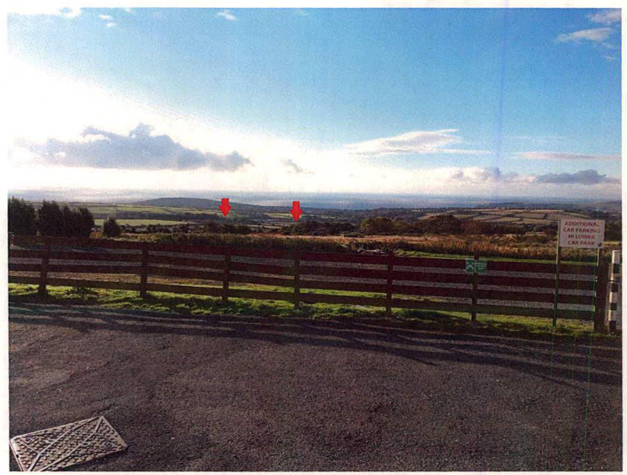
The below image was taken from the car park of the Creg Na Baa public house on 13 October 15. This image has been included because aside from Clypse Moar Road this is the only viewpoint from which one may expect members of the public to see the proposed development.
The photograph shows the southern vista from the car park, where the southern end of the Clypse reservoir is visible. The arrow to the left of the image points to the existing barn structure at Clypse Mooar Farm which is a significantly larger structure than the two proposed new dwellings. The right arrow points to the subject site.
What was obvious at the time of attempting to identify the location of these sites from the car park was the fact that they are imperceptible and thus have no visual impact from this point.
As such it can be concluded that reallocation of the residential curtilages and separation of the plots has no visual environmental impact when viewed by the public from the closest publically accessible southerly view of the site.
Due to their proximity to Clypse Moar Road the previous dwellings were visually intrusive to road users, and therefore had a high visual impact. This high visual impact would be replicated by the implementation of the extant planning permission.
The proposed dwellings will be situated 3 metres deeper into the site than the original as viewed from the road and as such they will be less visible from Clypse Moar Road than as previously approved.
There are no other publically accessible viewpoints of the site. If the question of effect on the environment considers the immediate visual impact of the proposed dwellings then the current proposal clearly results in an improvement to the visual environment than the original cottages or the approved replacements by virtue of the fact that they will be less visible.
The example that this development will set with regard to future local planning applications and decisions is an important factor for consideration.
In due course the Eastern Plan will call for more residential sites for development, and given the growth of development in this area, and its proximity to Douglas, it is expected that applications will be made for the residential use of more land in this vicinity. The development of a lower density residential scheme, set back from existing highways and that offers a genuine improvement to local amenities (the benefit of the road widening scheme) would establish a sustainable example for use as guidance for such future applications.
There are a number of recent planning approvals that establish the principals of the material amendments to the extant planning have been permitted elsewhere on the Island. These examples can be used to support the case for approval, and at the very least counter any argument that this proposed scheme creates a planning precedent.
Copyright in submitted documents remains with their authors. Request removal