Jim Davidson Project Coordinator Isle of Man Government, Highway Services Division Department of Infrastructure Ellerslie Depot Crosby Isle of Man IM4 2HA
Isle of Man Government, Highway Services Division Douglas Promenade
Functionality and Visual Appearance Audit
Contents
Section Page
1 Introduction 1
1.2 Scheme Evolution 1
1.3 Audit Methodology 2
1.4 PJA Audit Team 3
2 Functionality and Visual Appraisal Audit 4
2.1 Walking and Cycling 4
2.2 Public Transport 8
2.3 Highway Design and Car Parking 10
2.4 Materials and Street Furniture 12
3 Conclusions 14
Isle of Man Government, Highway Services Division Douglas Promenade
Functionality and Visual Appearance Audit
Appendices
Appendix A Scheme Plans 15
Douglas Promenade Isle of Man Government, Highway Services Division
Introduction
1 Introduction
1.1.1 Phil Jones Associates (PJA) in conjunction with TMS Consultancy have been instructed by the Highway Services Division of the Isle of Man Government to carry out a Stage One Quality Audit (QA) of a proposed scheme for a major remodelling of the Promenade in the town of Douglas.
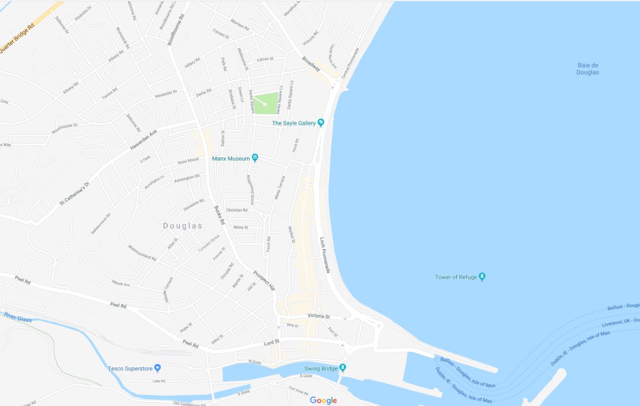
1.1.2 The scheme comprises proposals to upgrade The Promenade from its southern junction at Peveril Square, to just north of Broadway at the junction with Castle Mona Avenue.
Figure 1-1: Location and extent of the scheme
1.2 Scheme Evolution
1.2.1 A previous design scheme for Douglas Promenade was audited by PJA/TMS is May 2015. The scheme was refused planning consent, principally due to the proposed location of the Douglas horse tram on the Walkway.
1.2.2 The current scheme which is the subject of this audit represents updated designs prepared by the Highway Services Division at the Isle of Man Government, reflecting on the previous reasons for refusal and presenting an alternative design solution.
1.2.3 The revised design relocates the horse drawn tram to the northern side of Marine Gardens, on a segregated line from general traffic and pedestrians, situated between echelon parking and the existing footway.
Isle of Man Government, Highway Services Division 1 Douglas Promenade Functionality and Visual Appearance Audit
A digital location map showing the Douglas coastline, specifically highlighting the area around Loch Promenade and the Manx Museum.
1.2.4 In summary, the scheme the revised design broadly consists of:
• Removal of the existing signalised junction at Broadway and introduction of a new informal roundel junction.
• Creation of a new public space in front of the Sefton Hotel.
• Introduction of a new informal roundel junction at the junction with Church Road Marina.
• Retention of the existing twin horse tram tracks in the centre of the road from Castle Mona Avenue to Strathallan and relocation of a single horse drawn tram track on the seaward side of the highway (as opposed to walkway) towards the Sea Terminal.
• Rationalisation of the on-street parking, installing more echelon parking on the carriageway;
• Widening of some sections of footway and installation of footway build-outs at controlled and uncontrolled pedestrian crossings.
• Replacement of existing, and relocation of, pelican and puffin crossings with zebra crossings.
• Installation of higher quality paving throughout the Promenade.
1.3 Audit Methodology
1.3.1 To inform the QA three individual audits have been carried out: a Road Safety Audit and Mobility and Accessibility Audit by TMS; and the Functionality and Visual Appearance Audit by PJA. This report sets out the findings of the Functionality and Visual Appearance Audit.
1.3.2 The Functionality and Visual Appraisal audit has considered the design and operation of the public realm for various user groups, as follows:
• Pedestrians (including Public Transport Users);
• People with disabilities
• Cyclists;
• Public Transport Vehicles;
• Service Vehicles; and
• General Traffic.
1.3.3 The Audit took place on the afternoon of Thursday 16th November 2017 when the weather was fine and sunny and then continued on the morning of Friday 17th November when the weather was damp and drizzly. All three aspects of the Audit were undertaken at the same time on the 16th November with the team members in company during the site walkover. This allowed issues to be discussed from the perspective of all three aspects of the audit. Where the views of the auditors
Douglas Promenade 2 Isle of Man Government, Highway Services Division Functionality and Visual Appearance Audit
Introduction
differed, the issues were discussed, and a consensus reached on the most appropriate recommendations to make to the Highway Services Division.
1.4 PJA Audit Team
1.4.1 The PJA audit was undertaken by:
• Annabel Keegan – BA (Hons) Arch, MA Urban Design, MCIHT, Recognised UD Practitioner Associate, Phil Jones Associates
1.4.2 The findings of the audit have been reviewed by:
• Philip Jones – BSc (Hons) C Eng MICE, FICHT, FIHE (Hon) – Managing Director, Phil Jones Associates
1.4.3 Drawings provided by the Highway Services Division at the Isle of Man Government for the purpose of this audit are included in Appendix A of this report.
Isle of Man Government, Highway Services Division 3 Douglas Promenade Functionality and Visual Appearance Audit
2 Functionality and Visual Appearance Audit
2.1.1 Overall the auditors felt that the preliminary designs represent an improvement on the 2015 designs. Clear separation between the Promenade Walkway and horse drawn tram track provide a clearly defined public realm.
2.1.2 The remainder of the chapter is structured as follows:
• Section 2.1 - Walking and cycling
• Section 2.2 - Public transport
• Section 2.3 – Highway design and car parking
• Section 2.4 – Materials and street furniture
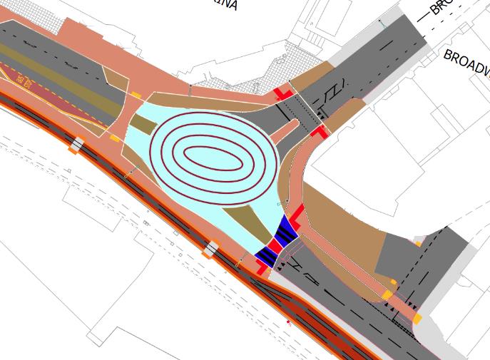
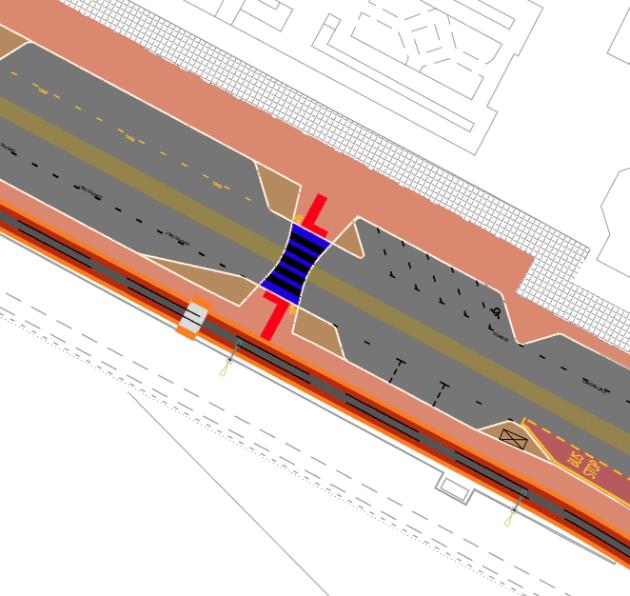
2.1 Walking and Cycling Problem A: Overall pedestrian crossing strategy rationale Location: Whole audit area
2.1.1 The preliminary design proposes the use of three different types of pedestrian crossings within the audit area, including a mixture of signalised crossings, implied zebra crossings and plain courtesy crossings.
2.1.2 It is unclear from the drawings provided what has led to the choice of crossing in different locations. For example, the proposed roundel located at the junction of Promenade and Broadway retains a signalised crossing on the northern arm with Broadway, provides an implied zebra crossing on the eastern arm and a courtesy crossing on the western arm.
2.1.3 Inconsistency in the type of crossing used may result in driver confusion and result in drivers only giving way to pedestrians at the signalised crossings and implied zebra crossings.
Douglas Promenade 4 Isle of Man Government, Highway Services Division Functionality and Visual Appearance Audit
Functionality and Visual Appearance Audit
Figure 2-1: Design: Crossing types at junction of Broadway and Promenade
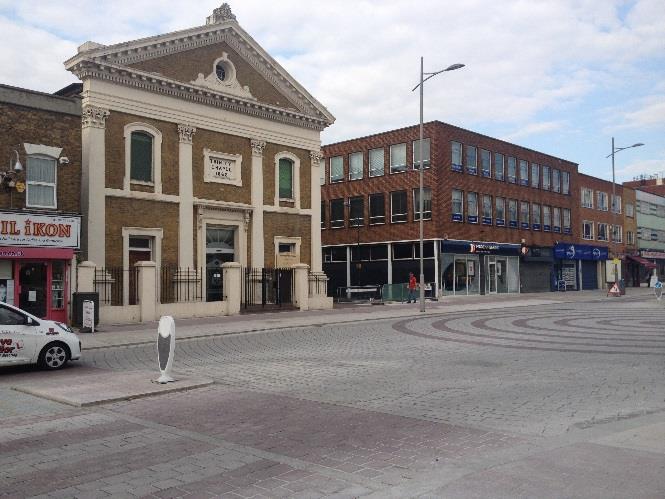
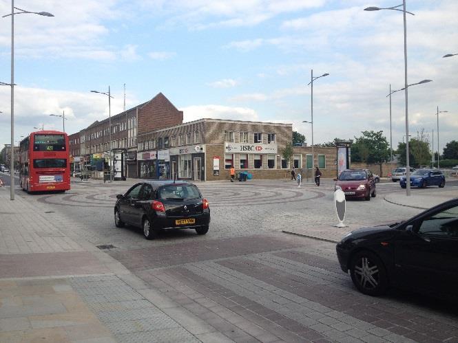
Figure 2-2: Precedent: Bexleyheath, London – uniformity in crossing type at junction of Broadway and Albion Road
Recommendation
2.1.4 It is recommended that crossing types within the scheme are rationalised to striped crossings to create uniformity on all arms. The use of a mixture of crossing types could lead to driver and pedestrian confusion and failure to give way to pedestrians.
Isle of Man Government, Highway Services Division 5 Douglas Promenade Functionality and Visual Appearance Audit
This is a color-coded site plan illustrating the proposed reconstruction of highways and footways. It details the layout of roads, pedestrian zones, and tram tracks along a promenade.A street-level photograph showing the Trinity Chapel building and a paved promenade area in Douglas, Isle of Man, featuring circular stone patterns.A street-level photograph showing a paved promenade area with a red bus, cars, and commercial buildings including an HSBC branch in the background.
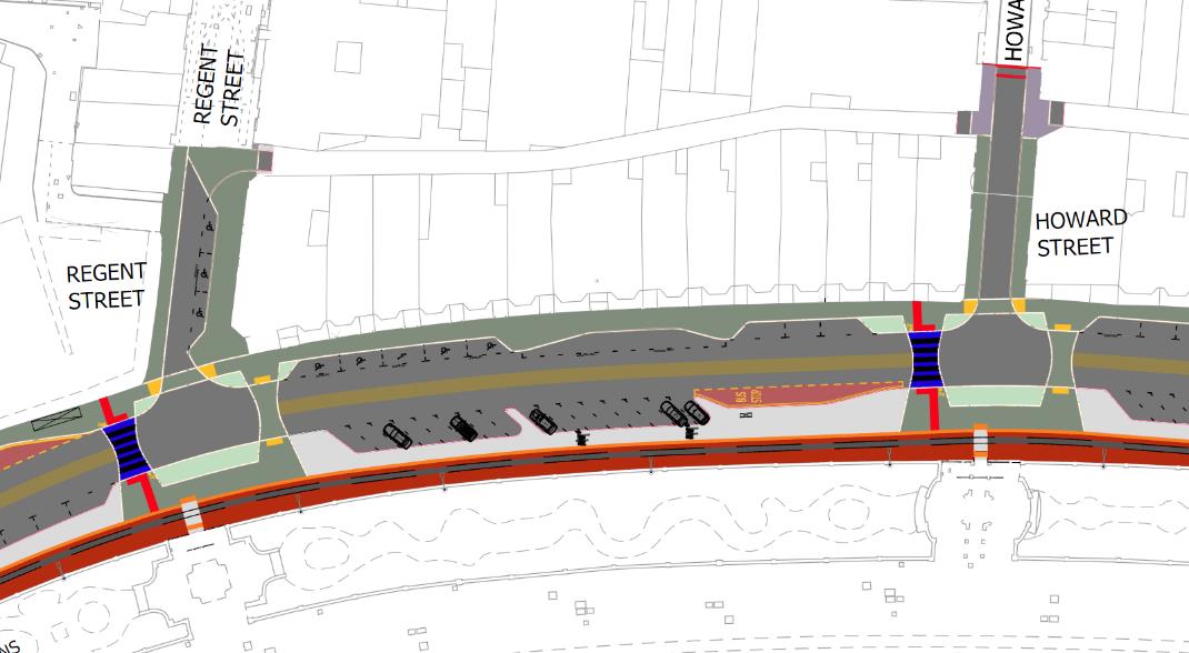
Problem B: Inconsistency in crossing type at side road junctions Location: Pedestrian crossings at side road junctions
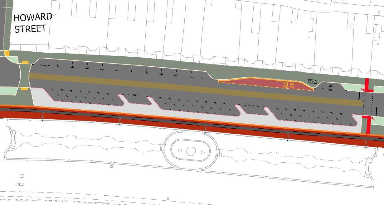
This image displays a technical site plan illustrating proposed highway and footway reconstruction along a coastal promenade. It shows the road alignment intersecting with Regent Street and Howard Street, including parking areas and tram track zones.
2.1.5 The design proposes pairs of pedestrian crossings located either side of the side road junctions with Regent Street and Howard Street. Zebra crossings are proposed on the southern side of the junction and courtesy crossings on the northern side, with pedestrian priority over the minor arm.
2.1.6 As detailed at problem A above, inconsistency in the type of crossing used at the junctions may result in driver confusion and result in drivers only giving way to pedestrians at the zebra crossing on the southern side of the junction.
Figure 2-3: Design: Pedestrian crossings at Regent Street and Howard Street
Recommendation
2.1.7 It is recommended that crossing types at these side road junctions are rationalised to create uniformity on all arms. The use of a mixture of crossing types could lead to diver confusion and failure to give way to pedestrians.
2.1.8 Figures 2-4 shows an implied zebra crossing on Arnsberg Way in Bexleyheath, London. The photograph shows the use of implied zebra crossings on both the entry and exit sides of the junction.
Douglas Promenade 6 Isle of Man Government, Highway Services Division Functionality and Visual Appearance Audit
Functionality and Visual Appearance Audit
Figure 2-4: Precedent: Bexleyheath, London – junction of Arnsberg Way
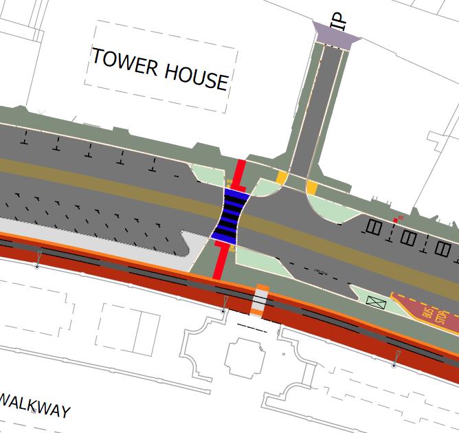
Problem C: Stagger of pedestrian crossings over the horse drawn tram track Location: Whole audit area
2.1.9 The design proposes the introduction of pedestrian crossing points at key locations along the horse drawn tram way, located to correlate with existing gaps / crossover points between the Promenade Walkway and Marine Gardens.
2.1.10 Pedestrian crossings of the tram are approximately 2.5m wide and aligned centrally with the Marine Garden crossovers. The position of these crossover points in relation to the proposed alignment of the crossings of the main Promenade carriageway results in staggers between the crossing points. The auditors felt that pedestrians crossing between Promenade Walkway and the main footway would be more likely to use the crossing if they lined up better.
Figure 2-5: Design: Staggered pedestrian crossings over horse drawn tram
Isle of Man Government, Highway Services Division 7 Douglas Promenade Functionality and Visual Appearance Audit
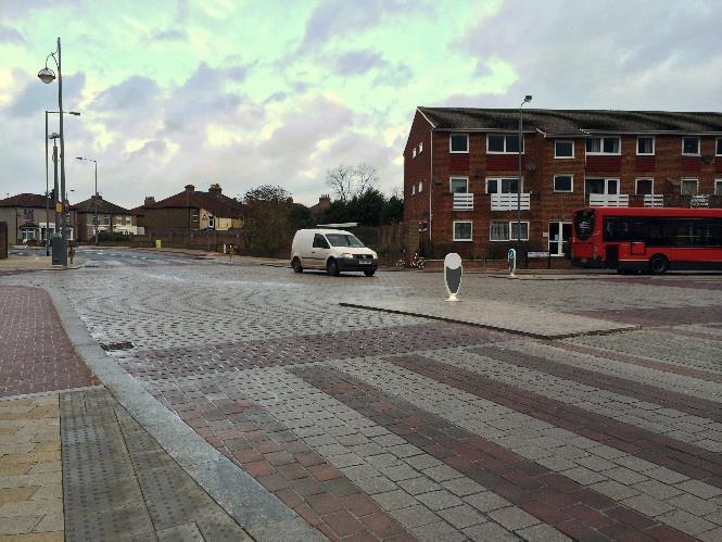
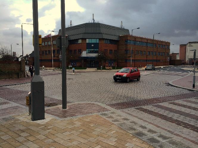
A street-level photograph showing a paved promenade area with patterned brickwork, street furniture, and nearby brick buildings, with a white van and red bus visible.A photograph showing a paved promenade area with new street furniture and a large brick leisure centre building in the background.A technical site plan illustrating highway and footway reconstruction works, showing road layouts, pedestrian zones, and building outlines like 'Tower House'.A technical site plan illustrating the proposed reconstruction of highways and footways on a coastal promenade, showing road markings, pavement areas, and tramway alignment.
Recommendation
2.1.11 Due to the location of the side roads on the northern side of the Promenade and the gaps in Marine Gardens it is not possible to align these points exactly.
2.1.12 It is therefore recommended that the controlled crossover points over the horse drawn tram track are widened to the full width of the existing gaps in Marine Gardens. This would mean that any stagger is minimised as people would feel more comfortable following their desire line as they crossed the tram track. Problem D: Cycling Provision and Facilities Location: Whole audit area
2.1.13 No details of a cycling strategy or provision for cyclists have been indicated on the drawings. Although cycling is currently allowed on the promenade between the gardens and the beach the extent to which cycle parking is to be provided for throughout the scheme is unknown. Recommendation
2.1.14 Consider carefully the cycling strategy and cycle parking provision throughout the scheme during the subsequent stages of the design.
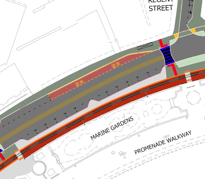
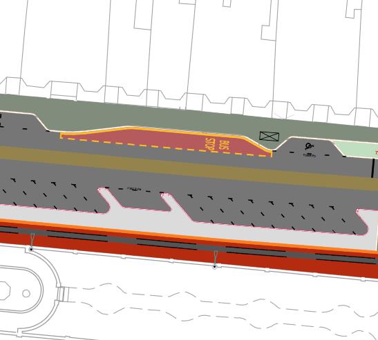
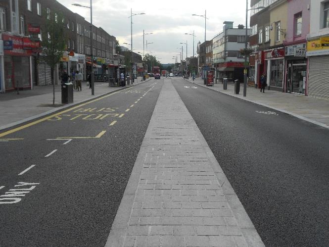
2.2 Public Transport Problem E: Use of bus lay-bys throughout the audit area Location: Whole audit area
2.2.1 The design proposes the use of off carriageway bus lay-bys along the length of Loch Promenade (continuation of the current arrangement).
2.2.2 Review of the bus routes along the promenade indicate that the services to Onchan and Laxey travel along the promenade. Services on the Onchan (red) line operate approximately every 20 minutes throughout the day, and the Laxey services (blue) operate a weekday service of two per day in the summer and 1 per day in the winter.
2.2.3 The provision of bus lay-bys also means that is some locations footway widths are narrow, when combined with the relocation of the associated bus shelter, or bus shelters situated in a sub-optimal location in relation to the bus lay-by.
Douglas Promenade 8 Isle of Man Government, Highway Services Division Functionality and Visual Appearance Audit
Functionality and Visual Appearance Audit
Figure 2-6: Design: Bus lay-by provision
2.2.4 The provision of the over-runnable central median would permit general traffic and other buses to ‘leap frog’ a stationary bus if necessary and would also have the added effect of reducing overall traffic speeds along the promenade to engender a more pedestrian friendly environment.
Figure 2-7: Precedent: Bexleyheath, London – over-runnable central median with in flow bus stops
Recommendation
2.2.5 Given the limited combined frequency of the services consideration should be given to in carriageway stopping of buses by removing the bus laybys. This would considerable space to be reallocated to pedestrians and would allow better siting of bus shelters relative to the bus stop position.
Isle of Man Government, Highway Services Division 9 Douglas Promenade Functionality and Visual Appearance Audit
The image displays a detailed engineering site plan illustrating the proposed reconstruction of a coastal promenade and highway alignment, including tramway tracks and pedestrian walkways.A technical engineering drawing showing a detailed cross-section or plan view of a coastal promenade road layout, including a bus stop zone and road surfaces.A street-level photograph showing a newly resurfaced promenade with a central paved section and asphalt roads, flanked by commercial buildings and street furniture.
2.3 Highway Design and Car Parking Problem F: Density of parking along length of audit area Location: Whole audit area
A technical site plan showing the proposed layout for highway and promenade reconstruction works, including road alignment, footways, and drainage infrastructure adjacent to Howard Street.
2.3.1 Whilst overall parking numbers appear to have reduced compared to the 2015 scheme, the overall density of parking along the scheme is still high, with some 120 car parking spaces provided along the length of the scheme, including 14 disabled spaces and 4 for electric vehicles, in addition to motorcycle parking, taxi bays, coach and bus laybys.
2.3.2 The combination of these along the length of the scheme results in the preliminary designs remaining dominated by car parking which could detract from the overall visual quality of the scheme.
Figure 2-8: Design: High density parking provision
Recommendation
2.3.3 It is recommended that an evaluation of the demand for parking along the promenade is undertaken to consider a potential reduction in overall numbers.
Douglas Promenade 10 Isle of Man Government, Highway Services Division Functionality and Visual Appearance Audit
Functionality and Visual Appearance Audit
Problem G: Potential conflict between car parking and people crossing the road as a result of central median
Location: Whole audit area
2.3.4 It is assumed that the central median is designed to be flush with the carriageway and over runnable for its length. This will help to visually narrow the narrow the carriageway and will also serve a secondary function of aiding pedestrians to informally cross the carriageway between dedicated crossing points.
Figure 2-9: Design: Central median
2.3.5 The proposed car parking makes it hard to get to / from the central median, particularly because of the use of echelon parking. Where central medians have been used effectively on other schemes within the UK, for example Bexleyheath in London, Poynton in Cheshire and Southall Broadway in London they have not been combined with on street parking to the degree proposed in Douglas. The proposed car parking makes it hard to get to / from the central median, particularly due to the use of echelon parking.
Figure 2-10: Precedent: Southall Broadway, London – central median used to assist informal pedestrian crossing movements
Isle of Man Government, Highway Services Division 11 Douglas Promenade Functionality and Visual Appearance Audit
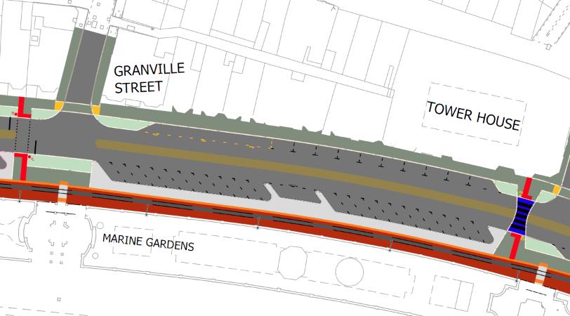
This image shows a site plan detailing proposed highway and footway reconstruction along a coastal promenade. It illustrates the new road alignment, tramway track, and associated landscaping near Granville Street and Marine Gardens.A street-level photograph showing a paved promenade or high street area with pedestrians, shops with awnings, and a visible drainage channel running along the edge.A street-level photograph showing a reconstructed promenade with new paving and road surfacing, featuring shops on the left and pedestrians on the wide footway.
Recommendation
2.3.6 It is recommended that alongside the general review of parking recommended at Problem F, that consideration is given to further breaking the long runs of continuous parking proposed, not only to provide visual relief but to also allow greater opportunity for informal pedestrian crossing to take place.
2.4 Materials and Street Furniture Problem H: Extent of material palette Location: Whole audit area
2.4.1 The 2015 audit commented that the palette of materials shown on the preliminary designs may be too wide and that this could result in a fragmented appearance which could reduce the legibility of the scheme.
2.4.2 The updated scheme proposes a similar range of materials, including a combination of tarmac, granite and block paving for footways and crossings, composite granite for striped crossings, tarmac and imprinted concrete for the carriageway and concrete for the horse drawn tramway. Recommendation
2.4.3 Consider rationalisation of the palette of materials and more consistency in their use especially where these are used to define pedestrian routes. Problem I: Street Furniture
2.4.4 No details of street furniture have been supplied at this stage of the design and cannot therefore be commented upon. Recommendation
2.4.5 Ensure that street furniture is located so as not to obstruct pedestrian movements on the footways areas. Where possible street furniture should be located on a constant alignment to minimise clutter.
Douglas Promenade 12 Isle of Man Government, Highway Services Division Functionality and Visual Appearance Audit
Functionality and Visual Appearance Audit
Problem J: Use of imprinted concrete in high trafficked areas Location: Whole audit area
2.4.6 As per our 2015 report, the Auditors are aware that in certain high trafficked areas especially where there are buses and other heavy vehicles turning, this type of surface can degrade and is difficult to repair/restore to its original condition. Recommendation
2.4.7 Consider carefully the areas where this type of surface is to be used and seek manufactures assurance that it is appropriate for the intended use.
Isle of Man Government, Highway Services Division 13 Douglas Promenade Functionality and Visual Appearance Audit
3 Conclusions
3.1.1 This report sets out the views of the independent Quality Audit team on the preliminary design proposals for the proposed Douglas Promenade.
3.1.2 The area subject to this audit comprises proposals to upgrade The Promenade from its southern junction at Peveril Square, to just north of Broadway at the junction with Castle Mona Avenue.
Douglas Promenade 14 Isle of Man Government, Highway Services Division Functionality and Visual Appearance Audit
Appendix A Scheme Plans
Isle of Man Government, Highway Services Division 15 Douglas Promenade Functionality and Visual Appearance Audit
Copyright in submitted documents remains with their authors. Request removal
Source & Provenance
Official reference
18/00003/B
Source authority
Isle of Man Government Planning & Building Control