Loading document...
March 2017
Hugh Logan Architects Bridge Court 10 Bridge Street Castletown Isle of Man IM9 1AX
PLANNING APPLICATION FOR THE DEMOLITION OF A REDUNDANT GAS STORAGE FACILITY, LEVELLING OF SITE, CONSTRUCTION OF RETAINING WALL AND USE FOR THE STORAGE OF SITE VEHICLES, CONTAINERS AND MATERIALS, BALTHANE INDUSTRIAL ESTATE, BALLASALLA, MALEW.A, MALEW
DESIGN AND PLANNING STATEMENT
1.0 Introduction 2.0 The Site and Surroundings 3.0 The Proposal 4.0 Access and Parking Provision 5.0 Drainage and Flood Risk 6.0 Environmental Protection 7.0 Planning Policy 8.0 Summary
Appendix A CTAS Site Investigation Report dated May 2015
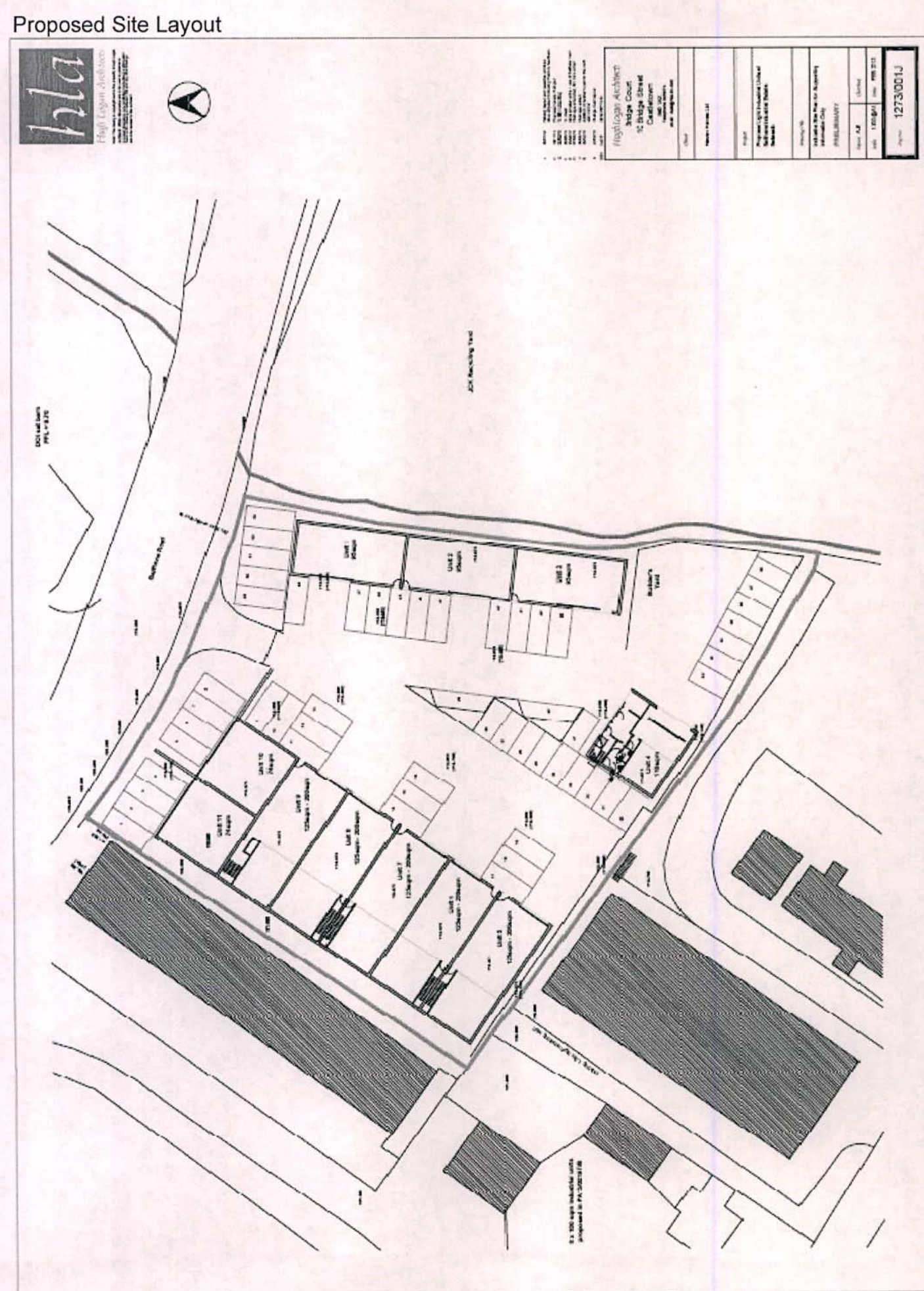
1.1 This application is for the demolition of the existing gas facilities on the site, the movement of soil from the higher part of the site to the lower part of the site and the construction of a retaining wall following excavation. 1.2 Once the levelling has taken place the applicant intends to use the site for the medium term storage of site vehicles, containers and materials.
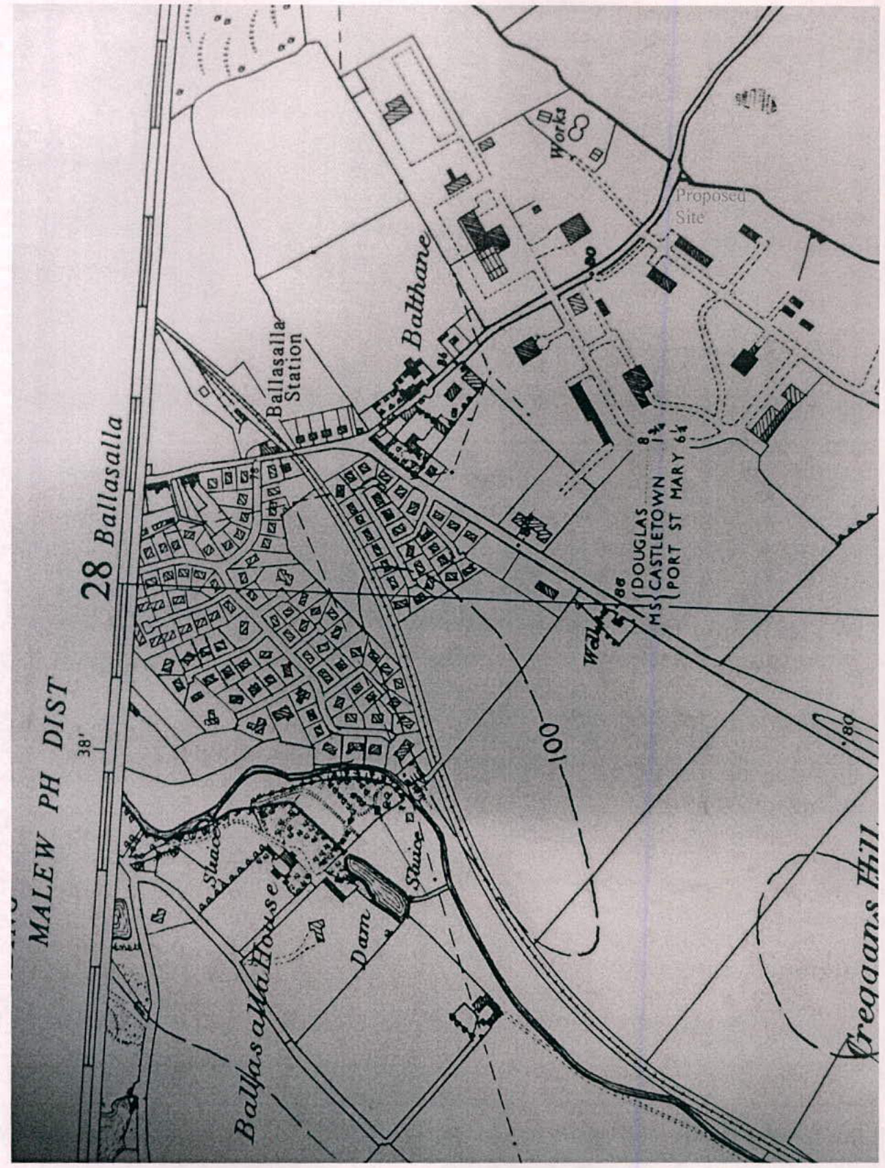
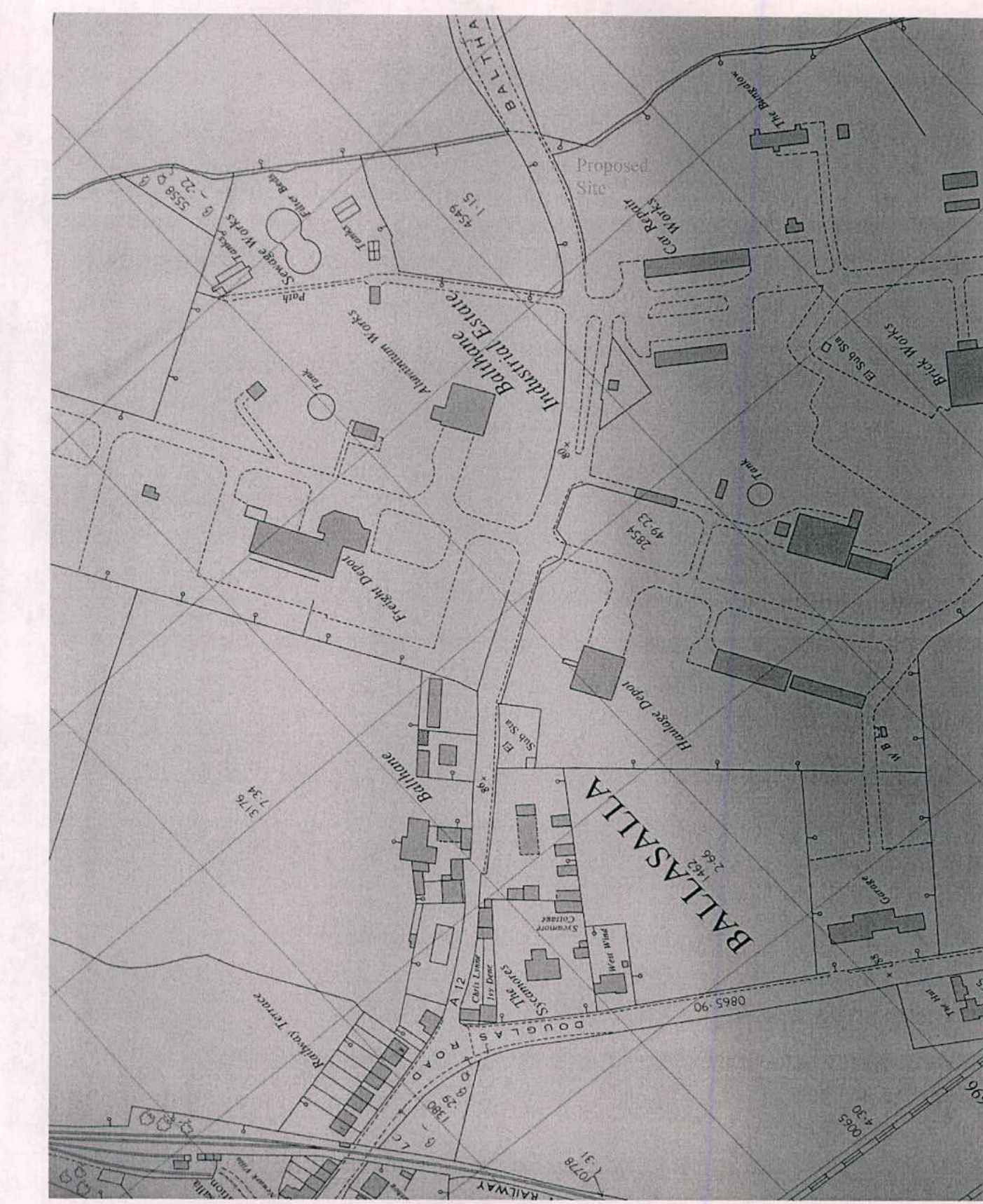
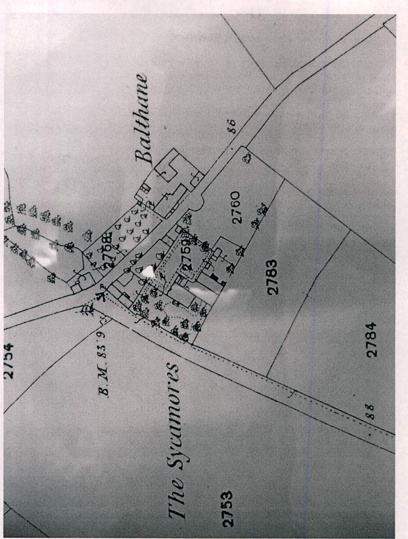
2.1 The site is a former gas storage facility in the Balthane Industrial Estate which, due to changes in the island's gas infrastructure, is no longer required. 2.2 The primary land use in the vicinity is industrial. To the south-east is the recycling facility operated by JCK Ltd. To the south-west are industrial units and the JCK yard and offices, to the north-west are existing industrial units and to the north-east is Balthane Road beyond which is the new DOI salt barn. 2.3 The total area of the proposed site is . 2.4 The site slopes upwards from the south-east to the north-west with the highest point being approximately 3 metres higher than the lowest point. 2.5 The site's south-eastern boundary is a stream called the Ronaldsburn.
3.1 The proposal is to excavate approximately 2 metres of soil from the Northwestern side of the site and relocate it to the South-eastern side of the site thereby raising the ground level by approximately 1 metre.
At the completion of the works most of the site will be level at a datum of 19.1 - 19.3 metres and little or no material will need to be removed from or imported to the site. 3.2 A retaining wall will be constructed 3 metres in front of the North-western boundary. This wall will be built in concrete and have a height of 2 metres. 3.3 Once completed the site will be covered in type 1 hardcore and used for the medium term storage of site vehicles, containers and materials when they are not required on the building sites. There will not be regular vehicle movements to and from the site and the storage of materials will not exceed 5 metres in height. 3.4 No additional security features are proposed for the site.
4.1 The site is presently accessed from Balthane Road to the northeast. This road already carries large industrial vehicles. 4.2 Access to the site will be via an existing entrance which is already capable of accommodating large vehicles. As the road becomes steeper to the north-west of the entrance any attempt to relocate the entrance would require significant additional earthworks. 4.3 The Department of Infrastructure's Highways Division raised no objection to the In Principle planning application PA16/00423/A which was approved on the 9th August 2016.
5.1 There is no hardstanding proposed as part of the scheme and there is no foul or surface water drainage required.
6.1 A Site Investigation Report (see Appendix A) was commissioned to investigate the possibility of contamination of the site. On page 5, the assessor concludes that, 'this site is not a significant contaminated area, according to the testing indicators...... and should not be classified as Contaminated Land'. 6.2 As the site is within 8 metres of a watercourse, the Ronaldsburn stream, consultation took place with the Fisheries Directorate of the Department of the Environment, Food and Agriculture at the In Principle stage. It was then confirmed that this is not a trout river and therefore this will not require restrictions on the period of construction. An 8m. Proximity Form will be submitted to the Department in conjunction with submission of this planning application.
7.1 The principal planning policy documents relating to this site are the Isle of Man Strategic Plan 2007 (the Strategic Plan) and the 2013 Area Plan of the South (the Area Plan). 7.2 The site is zoned as industrial on Map 4 of the Area Plan of the South.
8.1 The proposed uses are compatible with the land use zoning in the Area Plan. 8.2 The highways authority has raised no objection to the proposed access. 8.3 The site is not a significant contaminated area and should not be classified as Contaminated Land. 8.4 It is proposed the all excavated material will be retained within the curtilage of the site and there will be no need to dispose of soil off site.
CTAS Site Investigation Report dated May 2015
6 Bowring Road Ramsey Isle of Man IM8 2LQ Email: [email protected]
Contents: Title Page Contents ..... 2 Introduction ..... 3 General Introduction ..... 4 Factual Description ..... 5 Existing Site Plan ..... 6 Proposed Site Plan ..... 7 Logs of Trial Pit 1 ..... 8 Logs of Trail Pit 2 ..... 9 Logs of Trial Pit 3 ..... 10 Chemical Analysis sample 5483 ..... 11 Chemical Analysis sample 5482 ..... 12 Ordnance Survey Maps - 1975 ..... 13
Introduction
Name of Contract: Site Investigation, Gas Store Site, Balthane on the Isle of Man Client: Haven Homes Limited Douglas Isle of Man
Description of Site: Mainly level site with mounded earth structure around a horizontal gas storage tank Main Works Proposed and Purpose of this Report: Site investigation on ground conditions with contamination observations Scope of Investigation: Trial hole investigation with On-Site and laboratory Testing and analysis and research into previous uses and possible risks to further works
Geology and Ground Conditions: Bed rock SWIL -Skillicore Member, Packstone, siltstone and fine-grained sandstone; C21m, part of the Derbyhaven Formation (DBH), Packstone and grainstone with minor mudstone. Great Scar Limestone Group.
Overlaying soil type-glacially deposited boulder clay layered with sand and gravel Schedule of Drawings and Documents: Historic maps and proposed development
Particular Restrictions: Not applicable Particular General: Not applicable
General Introduction:
The comments given and the opinions expressed in this report are based on the soil conditions encountered, and in published research journals. There may, however, be special conditions obtaining at the site which have not been disclosed by this information and which have not been taken into account in this report.
The comments on ground-water conditions given in the records are based on observations made during the excavation of the Trial pits. It should be noted, however, that ground water levels vary due to seasonal or other effects.
The Geology of the Isle of Man - Trevor Ford, David Burnett \& David Quirk Geological Memoirs - GW Lampugh The Isle of Man Celebrating a Sense of Place: Late glacial \& Postglacial Environmental History
A New History of the Isle of Man Volume 1 and Volume 4
Solid \& Drift Geological Map—British Geological Survey Geology of the Isle of Man and its Offshore Area—British Geological Survey Isle of Man Street Guide-Ocean Publishing Google Earth Ordnance Survey Maps
Factual Description
Information obtained about this site situated on Balthane Industrial Estate, Ballasalla, Isle of Man, shows that up until the 1970's the land was used for agriculture.
A small stream runs along the east boundary of the site. In the late 1970's early 80's the fields were included in to the Industrial Estate and zoned for light industrial use. This is when the gas company obtained the land for the storage of bulk gas.
During the excavations of the trial holes insitu testing was carried out to determine the California Bearing Ratio, CBR, values at depths which should be able to support the foundations of the proposed structures.
Samples were also taken for chemical analysis to determine any possible contamination or possible sulphate attack of buried concrete. These sample results are shown on pages 11 and 12 of this report. No comments can be made by cTas about weather these results are acceptable to planning or not as the 'standard of safety factors' was withdrawn some years ago, so it is now down to the planning department of the Isle of Man as to the suitability of the site for further development.
Existing Site Plan with positions of Trial Pits {{image:122305}}
Report cTas/ 1665/15 Gas of Gas Store, Balthane
Trial Pit 1
Log not to scale
Hole remained DRY during excavation.
| Depth metres | Level Samples | Thickness metres | Description of Strata | Depth |
|---|---|---|---|---|
| Ground Level 0.65 | 0.65 | Grassed top soil, loamy Sand with a little coarse to fine angular gravel Made Ground | 0.65 | |
| 0.70 | 0.05 | Loose brown medium - fine Sand | 0.70 | |
| 1.70 | 1.00 | Dense dark brown loamy coarse - fine angular Gravel with some cobbles Made Ground | 1.70 | |
| 1.80 | Large boulder or bedrock | 1.80 | ||
| End of Hole |
| Depth metres | Level Samples | Thickness metres | Description of Strata | Depth Metres |
|---|---|---|---|---|
| GL 0.50 | 0.500 | Grassed top soil, loamy Sand with a little coarse to fine angular gravel Made Ground | 0.50 | |
| 0.80 | CBR 7% | 0.600 | Firm brown/gray fine sandy Silt with coarse to fine angular to sub-rounded gravel | 1.10 |
| 1.10 | ||||
| 2.30 | 1.400 | Soft gray fine sandy Silt with a little coarse to fine rounded to sub-rounded gravel With soft gray Clay lenses 20 to 50mm thick Becomes Damp at 2.30 m | 2.50 | |
| 2.50 | ||||
| End of hole |
Hole remained DRY during excavation.
Water level observations while hole left open
Trial Pit 3
Log not to scale
Hole remained DRY during excavation
Page 8 of 15
| Depth metres | Level Samples | Thickness metres | Description of Strata | Depth metres |
|---|---|---|---|---|
| GL | Loose medium to coarse rounded to sub-rounded gravels over lying Firm brown clayey Sand and Gravel with a trace of cobbles Made Ground | |||
| 0.55 | D5482 | |||
| 0.90 | D5483 CBR 10% | 2.100 | ||
| 2.10 | D5484 | 2.10 | ||
| End of hole Large boulder or Bed rock (Red Sandstone) |
NB: All results none accredited, done on a water extract 1:10 ratio
| pH | 7.33 | @25°C | |
| Conductivity | 58.8 | @25°C | |
| Dissolved oxygen | O | 8.09 | Mg/l |
| Oxygen saturation | O | 95 | % |
| Chemical oxygen demand | O | 13 | Mg/l |
| Alkalinity | HCO3 | 12.8 | Mg/l |
| Hardness | CaCO3 | 17.4 | Mg/l |
| Sodium | Na | 4.57 | Mg/l |
| Potassium | K | < 0.50 | Mg/l |
| Magnesium | Mg | 0.66 | Mg/l |
| Calcium | Ca | 5.87 | Mg/l |
| Ammonium | NH4 | 0.025 | Mg/l |
| Chloride | Cl | 2.94 | Mg/l |
| Nitrite | NO2 | < 0.05 | Mg/l |
| Nitrate | NO3 | 7.76 | Mg/l |
| Phosphate | PO4 | < 0.07 | Mg/l |
| Sulphate | SO4 | 5.16 | Mg/l |
| Lead | Pb | < 5 | μg/l |
| Copper | Cu | < 20 | μg/l |
| Zinc | Zn | 53.5 | μg/l |
| Iron | Fe | < 20 | μg/l |
| Manganese | Mn | < 5 | μg/l |
| Cadmium | Cd | < 0.5 | μg/l |
| Chronium | Cr | < 5 | μg/l |
| Nickel | Ni | < 5 | μg/l |
NB: All results none accredited, done on a water extract 1:10 ratio
| pH | 7.84 | @25°C | |
| Conductivity | 99.5 | @25°C | |
| Dissolved oxygen | O | 7.81 | Mg/l |
| Oxygen saturation | O | 91 | % |
| Chemical oxygen demand | O | 28 | Mg/l |
| Alkalinity | HCO3 | 27.1 | Mg/l |
| Hardness | CaCO3 | 34.6 | Mg/l |
| Sodium | Na | 9.95 | Mg/l |
| Potassium | K | 1.43 | Mg/l |
| Magnesium | Mg | 1.59 | Mg/l |
| Calcium | Ca | 11.2 | Mg/l |
| Ammonium | NH4 | 0.102 | Mg/l |
| Chloride | Cl | 3.49 | Mg/l |
| Nitrite | NO2 | 0.12 | Mg/l |
| Nitrate | NO3 | 7.12 | Mg/l |
| Phosphate | PO4 | 0.19 | Mg/l |
| Sulphate | SO4 | 9.35 | Mg/l |
| Lead | Pb | < 5 | μg/l |
| Copper | Cu | < 20 | μg/l |
| Zinc | Zn | 70.2 | μg/l |
| Iron | Fe | 124 | μg/l |
| Manganese | Mn | 8.3 | μg/l |
| Cadmium | Cd | < 0.5 | μg/l |
| Chronium | Cr | < 5 | μg/l |
| Nickel | Ni | 5.3 | μg/l |
Date of map: 1975 Scale 1:10560
Date of Map 1968 Scale 1:2500
Date of map 1868/9 Scale 1:2500
Copyright in submitted documents remains with their authors. Request removal