Planning Statement For The Creation Of Seating And Landscaped Area, Viewing Deck And Bat Boxes, Point Of Ayre Bird Reserve, Point Of Ayre
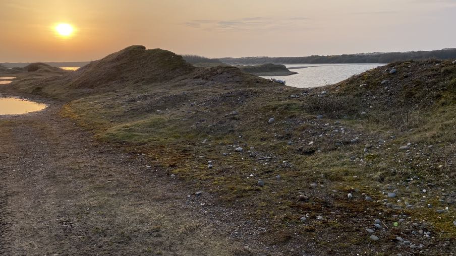
This photograph depicts a landscape view of a former quarry site featuring earth mounds, gravel paths, and small pools of water near a larger body of water. The scene captures the rugged terrain and natural surroundings at sunset, illustrating the area proposed for landscaping.
1.0 THE SITE
1.1 The site is part of an area of a former sand and gravel quarry at the Point of Ayre, approximately 500m to the south west of the lighthouse. The overall site amounts to approximately 40ha (98 acres) and comprises former quarry workings which have naturalised and now include a large lake with uneven ground, some having naturally revegetated and with a path network running around the water body.
1.2 There are no buildings currently on the site other than a container which received planning approval under 21/01208/B until 13.10.2026. The most up to date aerial photograph shows a shed on the site however, this has since been demolished. Permission has recently been granted for the erection of a bird hide and re-profiling works (22/00377/ B).
1.3 Access is available for motor vehicles from the public highway via a rough, wide lane which is owned by others, and which stops at a secured gate. No public access is currently available and the site is privately owned and managed as a bird sanctuary as an Area of Special Protection (ASP) for birds where special protection applies and access is restricted under the ASP Order and is subject to permission from the landowner. Bird Sanctuaries were designated under the Wild Birds Protection Act 1932. All wild birds in these areas are protected under their Orders and this includes protection from wilful disturbance of the nest or eggs. This reinforces the provisions of the Wildlife Act 1990 where:
All wild birds, their nests and eggs are protected by the Isle of Man Wildlife Act 1990. It is an offence, with certain exceptions, to:
1. intentionally or recklessly kill, injure or take any wild bird;
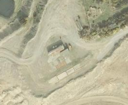
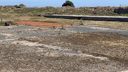
Aerial view of a former quarry site showing a small building, access tracks, and surrounding vegetation.A photograph showing a rough, undeveloped site with concrete slabs and a reddish rectangular area, likely a former quarry works area, with a grassy bank in the background.
2. intentionally or recklessly take, damage or destroy the nest of any wild bird while it is in use or being built;
3. intentionally or recklessly take or destroy the egg of any wild bird;
4. have in one’s possession or control any wild bird (dead or alive), part of a wild bird or egg or a wild bird which has been taken in contravention of the Act;
5. intentionally or recklessly disturb any wild bird listed on Schedule 1 while it is nest building or is in, on or near a nest with eggs or young; or disturb the dependent young of such a bird. A penalty of up to £5,000 for Schedule 1 species, or £2,500 for all other species can be imposed per offence.
1.4 A public footpath (17) runs to the southern edge of the site from Cranstal to the Ayres.
1.5 The short term objective for the site is for its reclamation for nature conservation purposes through a series of small scale work with a longer term aim of creating a much larger wildlife reserve on the former quarried areas and with public access where education and engagement can be provided without adversely affecting the wildlife that the sanctuary aims to protect and promote. Work has been ongoing on the site, repairing habitat, installing features which will support the species which do and could live, nest and/or breed within the site. The site supports myriad species of bird and other wildlife and is a unique habitat with significant potential for further enhancement for biodiversity.
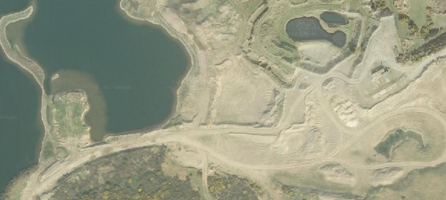
An aerial satellite view of a former quarry site adjacent to a large body of water, showing disturbed earth, access tracks, and small ponds.
1.6 The undertaking of work within the site is seasonally sensitive as the site is used and occupied by a significant range of birds and avoiding intrusive work within the breeding and nesting seasons is imperative.
1.7 The current proposal is moving the development of the reserve forward by improving the visual appearance at the entrance area and providing areas for seating.
2.0 THE DEVELOPMENT
2.1 Proposed is a series of works largely at the entrance to the reserve to provide a more attractive area and opportunities for seating. Currently access to the site is on the basis of invited and accompanied visitors to learn about the biodiversity of the area and for study thereof. It is proposed to broaden this to the general public, starting with two or three days a week with staff and volunteers being on site initially. Longer term, once the applicant understand how the site is being used, it is hoped that the opening hours will be extended. All of the measures proposed and to be introduced are to minimise the impact of wildlife on this increased human presence.
2.2 Also proposed is the installation of two poles which will support bat boxes. The reserve is a good feeding areas for bats with most of the Isle of Man’s resident species having been recorded here although there are not many natural bat roosts so the bat boxes, which are being proposed in conjunction with the Manx Bat Group, will be a valuable addition.
2.3 The works involve the re-profiling of an area close to the site entrance to provide new mounds arranged around a central area with a path maintained around the works to provide access to the remainder of the site. The ground will be mounded as shown in the section drawings and benches provided within the central area which will feature a small stone cairn. New planting will be introduced largely from seeds or transplants from within the site with opportunities for art work around the outer paths.
2.3 The poles supporting the bat boxes will be telegraph poles up to 4m in height with the bat box secured to the top. The location for these is shown on the location plan 01.
3.0 Planning Policy
3.1 The site is designated on the Isle of Man Planning Scheme (Development Plan) Order 1982 as within an area of an area of High Landscape or Coastal Value and Scenic Significance, within a nature conservation zone, nature reserves and sits of ecological importance for conservation and with a small, oval shaped area identified as an area for surface mineral working (gravel).
3.2 The Cabinet Office is currently preparing an Area Plan for the North where there has been a submission for the land immediately to the south to be designated for mineral extraction (which is shown on the draft Proposals Map) with a 100m buffer zone at its boundaries. The new Area Plan includes references to environmental enhancement, referring to the Strategic Plan where it states:
“Opportunities for environmental enhancement, such as tree planting, the removal of eyesores and the management of habitats will need to be identified in Area Plans with the full involvement and support of local communities”. Such opportunities may include former mining areas which have been or are in the process of being reclaimed. Appropriate reclamation should protect or enhance features of industrial or archaeological significance.”
3.3 The document also states: “3. All statutory and important non-statutory designations in the North and West will be recorded on the Environmental, Community and Infrastructure Constraints Maps.” The site itself is not designated for development on the overall Proposals Map and is highlighted as an Area of Special Protection within a wider area of ecological importance. Part of the site including the proposed bat box locations but excluding the area for the visitor facilities, falls within the area to be safeguarded for the protection of minerals.
3.4 There are no Registered Trees or Buildings on the site although the Point of Ayre lighthouses and foghorn are protected (RBs 147, 298 and 297) and it is not within any Conservation Area. Small patches of ground within the site are identified as being at risk of surface water flooding on the national flood risk maps.
3.5 The Landscape Character Assessment was published by Department of Environment, Food and Agriculture in and designates the application site and surrounding area to the
north, west and east as Smooth Coastal Strip - G2 The Ayres and where the following advice is provided in the draft PPS The Role of Landscape Character in Development:
"Type G: Smooth Costal [sic] Strip The overall strategy for the protection and enhancement of the Smooth Coastal Strip Landscape Character Type is to conserve and enhance: the simple and uncluttered inter-tidal landscape; the strong sense of remoteness and tranquillity; the expansive seascape views dominated by extensive beaches and wide, open skies; and the diverse patchwork of highly sensitive coastal habitats.
Key landscape planning considerations in relation to the protection and enhancement of this Landscape Character Type are as follows:-
(a) Generally, housing and business development would be out of place within the predominantly visually open and uncluttered landscape of the Smooth Coastal Strip;
(b) Where built development is permitted, it should be small-scale, and buildings should avoid particularly exposed or visually prominent locations that would intrude into expansive views towards the sea, and should reflect local building materials and styles;
(c) Care should be taken to minimise urban influences within the undeveloped landscape;
(d) Sensitive design of coastal defences should be encouraged, such as to minimise adverse effects on the natural profile of the landscape;
(e) Where tourist and recreational development is required, it should be sensitively designed to respect local building materials and styles, and particular care should be taken to avoid development or infrastructure that would exert a strong urban influence over the surrounding landscape;
(f) Tall telecommunications development would be out of place within this predominantly open and highly visually sensitive landscape;
(g) The boundaries of sand and gravel extraction sites should include appropriate native structure planting to enhance the transition to the wider landscape; restoration schemes should be so designed as to strengthen the character of the Smooth Coastal Strip.”
3.6 As the site is not designated for a particular purpose on the development plan, there is a presumption against development here as set out in General Policy 3 and where Environment Policies 1 and 2 protect the countryside and the landscape quality as the most important considerations.
3.7 General Policy 3 sets out exceptions to this general presumption including “(h)buildings or works required for interpretation of the countryside, its wildlife or heritage”.
3.8 Ecology is protected in Environment Policy 4 including species of international, national or local importance, designated National Nature Reserves, Areas of Special Protection and Bird Sanctuaries. More specifically, watercourses and wetlands and their associated ecology are protected in Environment Policy 7 which also requires applications which could cause demonstrable harm to a watercourse, wetland, pond or dub to demonstrate how this will not happen including phasing and details of the works involved.
3.9 There is encouragement for environmental enhancement:
Environment Policy 27: The Department will seek to enhance the natural environment, including sites contaminated by former mine workings, along with other Government Departments, local communities, the private sector and all appropriate agencies in order to ensure the appropriate reclamation, water management, planting of appropriate tree species, the management of special habitats including aquatic habitats and the removal of eyesores.
4.0 Planning History
4.1 The site has been the subject of three recent applications which were all approved: 21/00929/B application proposed the creation of three ponds, the repair of a gravel bund and creation of two gravel islands within the site all related to the ecological enhancement of the site. The land round about has been the subject of years of proposals for mineral extraction and waste disposal, some of which involve restoration of these sites postcompletion, for nature conservation with a longer term objective of public access and facilities for visitors to understand and observe the wildlife whose habitats are being protected and enhanced.
4.2 21/01208/B proposed the siting of a container for storage on the site.
4.3 22/00377/B proposed the re-profiling of the land around the lake and the installation of a bird hide.
4.4 All of these applications were permitted.
5.0 Assessment
5.1 The proposal involves development which will enhance the appearance of the site by the introduction of new planting, the formation of areas for seating and the enhancement of the ecological value of the site by the introduction of bat roosting and hibernation opportunities.
5.2 There is an ultimate objective of having public access to the site and facilities for the appreciation and interpretation of the wildlife that is being protected and enhanced, although much of that will be facilitated by future development proposals which have yet to be submitted. The works proposed here are a first step to provided facilities for visitors. There is no intention short or long term for this to become an open recreation facility and the focus is and will remain the protection and enhancement of the biodiversity of this very special area and those who will visit will be those wishing to learn and/or appreciate the natural wildlife that occupies the site. working on the creation of a nature reserve. Whilst the applicant is working towards the facilitation of visitor access, this remains a wild area with the prime focus on the wildlife. Therefore, as is common practice, there are no immediate plans for providing toilets. A nearby example would be Close Sartfield. If in the future the applicant is able to increase the visitor facilities by way of a visitor centre etc, then at that point toilet facilities would be considered to be provided.
5.3 There is a significant area between the public highway and the site entrance which is used by those visiting the site and which can accommodate a significant amount of vehicles.
5.4 The development, like its predecessors, is considered to satisfy General Policy 3h of the Strategic Plan and protecting the countryside in accordance with Environment Policies 1 and 2 as well as continuing to enhance the previously damaged environment, in accordance with Environment Policy 27.
Sarah Corlett 30.08.23
Copyright in submitted documents remains with their authors. Request removal
Source & Provenance
Official reference
23/01038/B
Source authority
Isle of Man Government Planning & Building Control